UPSC Exam > UPSC Notes > Current Affairs & Hindu Analysis: Daily, Weekly & Monthly > Geography: October 2022 Current Affairs
Geography: October 2022 Current Affairs | Current Affairs & Hindu Analysis: Daily, Weekly & Monthly - UPSC PDF Download
| Table of contents |

|
| Global Status of Multi-Hazard Early Warning Systems: Target G |

|
| Cyclone Sitrang |

|
| Mediterranean Sea |

|
| Strait of Malacca |

|
| Red Sea |

|
| Kuril Islands |

|
Global Status of Multi-Hazard Early Warning Systems: Target G
Why in News?
- Recently, the United Nations Office for Disaster Risk Reduction (UNDRR) and the World Meteorological Organization (WMO) released a report titled Global Status of Multi-Hazard Early Warning Systems - Target G, which warns that half of the countries globally are not protected by Multi-Hazard Early Warning Systems (MHEWS).
- The report has been released to mark the International Day for Disaster Risk Reduction (13th October).
- The analysis was made with data from the targets outlined in The Sendai Framework (2015-2030). The framework is a global blueprint for disaster risk reduction and prevention.
- Of the seven targets in the framework, Target G aims to “substantially increase the availability of and access to multi-hazard early warning systems and disaster risk information and assessments to the people by 2030.
What is International Day for Disaster Risk Reduction?
- The International Day for Disaster Risk Reduction was started in 1989, after a call by the United Nations General Assembly for a day to promote a global culture of risk-awareness and disaster reduction.
- In 2015 at the Third UN World Conference on Disaster Risk Reduction in Sendai, Japan, the international community was reminded that disasters hit hardest at the local level with the potential to cause loss of life and great social and economic upheaval.
What are the Early Warning Systems?
- Early warning systems are a proven means to reduce harm to people and damage to assets ahead of impending hazards, including storms, tsunamis, droughts, and heatwaves, to name a few.
- Multi-hazard early warning systems address several hazards that may occur alone, simultaneously, or cascadingly.
- Many systems only cover one type of hazard - like floods or cyclones.
What are the Findings?
- Failure at Investment:
- The world is failing to invest in protecting the lives and livelihoods of those on the front line.
- Those who have done the least to cause the climate crisis are paying the highest price.
- LDCs (Least developed countries), SIDS (Small Island Developing States), and countries in Africa, require the most investment to increase early warning coverage and adequately protect themselves against disasters.
- Pakistan is dealing with its worst recorded climate disaster, with nearly 1,700 lives lost. Despite this carnage, the death toll would have been much higher if not for early warning systems.
- Significant Gaps:
- Only half of the countries globally have MHEWS.
- The Number of recorded disasters has increased five-fold, driven in part by human-induced climate change and more extreme weather. This trend is expected to continue.
- Less than half of the Least Developed Countries and only one-third of Small Island Developing States have a multi-hazard early warning system.
- Humanity is in the Danger Zone:
- As ever-rising greenhouse gas emissions are supercharging extreme weather events across the planet, climate disasters are hurting countries and economies like never before.
- Increasing calamities are costing lives and hundreds of billions of dollars in loss and damage.
- Three times more people are displaced by climate disasters than war and half of humanity is already in the danger zone.
What are the Recommendations?
- Called on all countries to invest in early warning systems.
- As climate change causes more frequent, extreme, and unpredictable weather events, investment in early warning systems that target multiple hazards is more urgent than ever.
- This is because of the need to warn not only against the initial impact of disasters, but also second and third-order effects. Examples include soil liquefaction following an earthquake or a landslide, and disease outbreaks following heavy rainfall.
What are India's Efforts in Managing Disaster?
- Establishment of National Disaster Reaction Force (NDRF):
- India has increasingly mitigated and responded to all types of disasters, including with the establishment of its National Disaster Reaction Force (NDRF), the world’s largest rapid reaction force dedicated to disaster response.
- India’s Role as a Foreign Disaster Relief:
- India’s foreign humanitarian assistance has increasingly included its military assets, primarily deploying naval ships or aircraft to deliver relief.
- In line with its diplomatic policy of “Neighbourhood First,” many of the recipient countries have been in the region of South and Southeast Asia.
- Contribution to Regional Disaster Preparedness:
- Within the context of the Bay of Bengal Initiative for Multi-Sectoral Technical and Economic Cooperation (BIMSTEC), India has hosted DM Exercises that allow NDRF to demonstrate for counterparts from partner states the techniques developed to respond to various disasters.
- Other NDRF and Indian Armed Forces exercises have brought India’s first responders into contact with those from states in the South Asian Association for Regional Cooperation (SAARC) and the Shanghai Cooperation Organisation (SCO).
- Managing Climate Change related Disaster:
- India has adopted the Sendai Framework for Disaster Risk Reduction, the Sustainable Development Goals (2015-2030), and the Paris Agreement on Climate Change, all of which make clear the connections among DRR, Climate Change Adaptation (CCA), and sustainable development.
Cyclone Sitrang
In News
- Recently, Cyclone Sitrang made landfall in southern Bangladesh taking the death toll to 35 and millions other remained without power in the country.
- It is the first tropical cyclone of the post-monsoon season of 2022. It also helped Delhi record its cleanest post-Diwali air since 2015.
About Cyclone Sitrang
- The name Sitrang has been given by Thailand.
- The last October cyclone in the Bay of Bengal was Titli in 2018.
- It developed in the Bay of Bengal before turning north toward Bangladesh’s vast coast. The maximum wind speed was 88 kmh.
- A red alert indicating heavy to very heavy and extremely heavy rainfall under the influence of cyclone was issued for Assam, Meghalaya, Mizoram, and Tripura.
- The IMD is one of the world’s six RMSCs mandated to provide cyclone advisories and alerts to 13 member countries Bangladesh, India, Iran, Maldives, Myanmar, Oman, Pakistan, Qatar, Saudi Arabia, Sri Lanka, Thailand, United Arab Emirates and Yemen.
- Affected regions:
- Andaman and Nicobar Islands, Odisha, West Bengal and Bangladesh, particularly the coastal districts.
Why storms in October?
- The months of October-November and May-June see storms of severe intensity develop in the North Indian Ocean comprising the Bay of Bengal and the Arabian Sea.
- In the past 131 years, October saw 61 storms develop in the Bay of Bengal.
- The east coast, notably Odisha, has faced many of its severest storms in October, including the Super Cyclone of 1999.
- After the withdrawal of the Southwest monsoon, there is a rise in ocean heating, this leads to rise in sea surface temperature over the Bay of Bengal.
- The atmospheric moisture availability over the ocean region, too, is higher.
- So, when remnant systems from the South China Sea reach the Bay of Bengal, they get conducive conditions, aiding the formation and intensification of cyclones in October.
- In some years, ocean-atmospheric factors hinder this phenomenon.
- In 2020, weak La Nina conditions along the equatorial Pacific Ocean prevented a cyclonic formation near India’s coasts.
Cyclones in the Arabian Sea
- In comparison with the Bay of Bengal, only 32 storms have developed in the Arabian Sea in October since 1891.
- Climatologically too, the IMD states that of the five storms formed in the North Indian Ocean in a calendar year, four are in the Bay of Bengal and one in Arabian Sea.
What is a Cyclone?
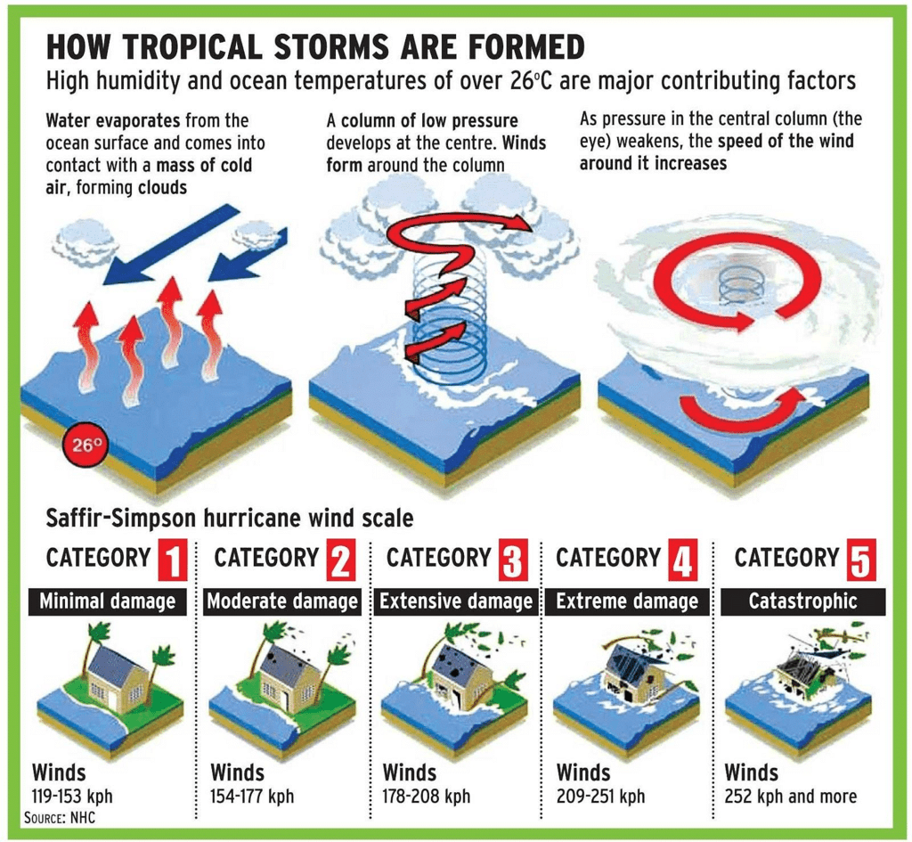
- A cyclone is any low-pressure area with winds spiralling inwards and is caused by atmospheric disturbances around a low-pressure area distinguished by swift and often destructive air circulation.
- The air circulates inward in an anticlockwise direction in the Northern hemisphere and clockwise in the Southern hemisphere.
- The amount of pressure drop in the center and the rate at which it increases outwards gives the intensity of the cyclones and the strength of winds.
- Eye: The centre of a cyclone is a calm area. It is called the eye of the storm. The diameter of the eye varies from 10 to 30 km. It is a region free of clouds and has light winds.
- High-speed winds: Around this calm and clear eye, there is a cloud region of about 150 km in size. In this region there are high-speed winds (150–250 km/h) and thick clouds with heavy rain. Away from this region the wind speed gradually decreases.
- A large cyclone is a violently rotating mass of air in the atmosphere, 10 to 15 km high.
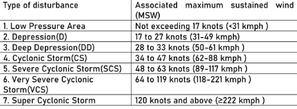
- The criteria followed by the India Meteorological Department (IMD) to classify the low pressure systems in the Bay of Bengal and in the Arabian Sea as adopted by the World Meteorological Organisation (W.M.O.) are given in the following Table:
Types of Cyclones
- Tropical Cyclone: Cyclones that develop in the regions between the Tropics of Capricorn and Cancer are called tropical cyclones. Tropical cyclones are large-scale weather systems developing over tropical or subtropical waters, where they get organised into surface wind circulation.
- Extra tropical Cyclone (also called Temperate Cyclone): They occur in temperate zones and high latitude regions. In contrast with tropical cyclones, extratropical cyclones produce rapid changes in temperature and dew point along broad lines, called weather fronts, about the center of the cyclone.
Formation of Cyclones
- Before cloud formation, water takes up heat from the atmosphere to change into vapour. When water vapour changes back to liquid form as raindrops, this heat is released to the atmosphere.
- The heat released to the atmosphere warms the air around. The air tends to rise and causes a drop in pressure. More air rushes to the centre of the storm. This cycle is repeated.
- The chain of events ends with the formation of a very low-pressure system with very high-speed winds revolving around it. It is this weather condition that is called a cyclone.
Conditions favouring the formation and intensification of tropical cyclone storms
- Sea surface with a temperature higher than 27° C,
- Coriolis force,
- Small differences in the vertical wind speed,
- Weak- low-pressure area.
To Read more about cyclones: Click here
Mediterranean Sea
 Key Points
- Physical Geography:
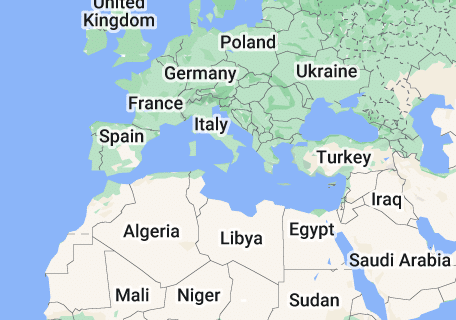
- A sea of the Atlantic Ocean, lies between the continents of Eurasia and Africa enclosed almost completely by land.
- Bordering Countries (21 countries): Albania, Algeria, Bosnia and Herzegovina, Croatia, Cyprus, Egypt, France, Greece, Israel, Italy, Lebanon, Libya, Malta, Monaco, Montenegro, Morocco, Slovenia, Spain, Syria, Tunisia, and Turkey.
- To the west it is connected to the Atlantic Ocean through the Strait of Gibraltar, to the east with the Black Sea through the Dardanelles Straits, and to the south with the Red Sea through Suez Canal.
- Nile river (Africa) drains into the Mediterranean Sea.
- Recent Related Events:
- Western Disturbances
- Bomb Cyclone
- Maiden Navy Exercise: India-Algeria
- Grand Ethiopian Renaissance Dam’s (GERD) on Nile
To know more about mediterrenean sea, Click here
Strait of Malacca
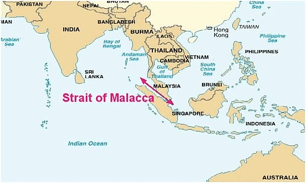
- Straits of Malacca is a narrow stretch of water, 580 mi (930 km) in length, between the Malay Peninsula (Peninsular Malaysia) and the Indonesian island of Sumatra.
- As the main shipping channel between the Indian Ocean and the Pacific Ocean, it is one of the most important shipping lanes in the world.
- It is named after the Malacca Sultanate that ruled over the archipelago between 1400 and 1511, the center of administration of which was located in the modern-day state of Malacca, Malaysia.
- From an economic and strategic perspective, the Strait of Malacca is one of the most important shipping lanes in the world.
To read more information on straits, Click here
Red Sea
- Location
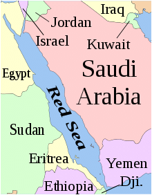
- The Red Sea is a seawater inlet of the Indian Ocean, lying between Africa and Asia.
- Borders
- Its connection to the ocean is in the south, through the Bab el Mandeb strait and the Gulf of Aden. To its north lie the Sinai Peninsula, the Gulf of Aqaba, and the Gulf of Suez (leading to the Suez Canal).
- The sea separates the coasts of Egypt, Sudan, and Eritrea to the west from those of Saudi Arabia and Yemen to the east.
- Biodiversity
- The Red Sea also has extensive shallow shelves, noted for their marine life and corals.
- Topography
- The Red Sea was formed by the Arabian Peninsula being split from the Horn of Africa by movement of the Red Sea Rift.
- The Red Sea is one of the saltiest bodies of water in the world, owing to high evaporation and low precipitation; no significant rivers or streams drain into the sea.
- Trade
- The Red Sea is part of the sea roads between Europe, the Persian Gulf and East Asia, and as such has heavy shipping traffic.
To read more information on Seas, Click here
Kuril Islands
Key Points
- Physical Geography:
- Kuril Islands are stretched from the Japanese island of Hokkaido to the southern tip of Russia's Kamchatka Peninsula separating Okhotsk Sea from the North Pacific ocean.
- It consists of 56 islands and minor rocks. The chain is part of the belt of geologic instability circling the Pacific (Ring of Fire) and contains at least 100 volcanoes, of which 35 are still active, and many hot springs.
- Earthquakes and tidal waves are common phenomena over these islands.
- Russia-Japan Dispute:
- The Kuril Islands dispute between Japan and Russia is over the sovereignty of South Kuril Islands.
- The South Kuril Islands comprise Etorofu island, Kunashiri island, Shikotan island and the Habomai island.
- These islands are claimed by Japan but occupied by Russia as the successor state of the Soviet Union.
- Japan calls the Islands as Northern Territories and Russia as the South Kuril.
The document Geography: October 2022 Current Affairs | Current Affairs & Hindu Analysis: Daily, Weekly & Monthly - UPSC is a part of the UPSC Course Current Affairs & Hindu Analysis: Daily, Weekly & Monthly.
All you need of UPSC at this link: UPSC
|
38 videos|5293 docs|1118 tests
|
FAQs on Geography: October 2022 Current Affairs - Current Affairs & Hindu Analysis: Daily, Weekly & Monthly - UPSC
| 1. What is the significance of Multi-Hazard Early Warning Systems? |  |
Ans. Multi-Hazard Early Warning Systems play a crucial role in minimizing the impact of natural disasters by providing timely and accurate information to communities at risk. These systems help in mitigating the loss of lives, protecting infrastructure, and enabling communities to take appropriate actions in response to various hazards.
| 2. What is the current global status of Multi-Hazard Early Warning Systems? |  |
Ans. The global status of Multi-Hazard Early Warning Systems varies across different regions. While some countries have well-established and robust systems in place, others still face challenges in terms of infrastructure, resources, and coordination. The Global Status Report on Multi-Hazard Early Warning Systems provides comprehensive information on the current status and progress made by countries in implementing these systems.
| 3. How does Cyclone Sitrang impact the Mediterranean Sea region? |  |
Ans. Cyclone Sitrang does not directly impact the Mediterranean Sea region as it primarily affects the Indian Ocean and the Bay of Bengal. However, cyclones in the Indian Ocean can indirectly influence weather patterns in neighboring regions, including the Mediterranean Sea, through their impact on global atmospheric circulation.
| 4. Why is the Strait of Malacca prone to hazards? |  |
Ans. The Strait of Malacca is prone to hazards due to its geographical location and heavy maritime traffic. Being one of the busiest shipping lanes in the world, the strait is vulnerable to accidents, oil spills, and maritime collisions. Additionally, the region is also susceptible to natural hazards such as tropical cyclones and tsunamis.
| 5. How does the Red Sea region benefit from Multi-Hazard Early Warning Systems? |  |
Ans. Multi-Hazard Early Warning Systems provide valuable information and alerts to the Red Sea region, helping communities and authorities prepare for and respond to various hazards. This includes early warnings for tropical cyclones, extreme weather events, marine hazards, and other threats that can impact the coastal areas and maritime activities in the Red Sea.
Related Searches

