Transport in India - 1 | Famous Books for UPSC Exam (Summary & Tests) PDF Download

Introduction
Transportation and communication play crucial roles in fostering the expansion and prosperity of trade and commerce. They facilitate the movement of goods, commodities, and ideas across different regions, contributing to economic development. Whether it's trade within a small village or on an international scale, a robust economy relies on efficient transportation and communication networks. Effective communication is essential for ensuring the smooth operation of transportation systems, and conversely, efficient transportation is a prerequisite for effective communication. Migration between areas is enabled by transportation, leading to the growth of industries and trade. In essence, the synergy between transportation and communication is vital for the interconnected and dynamic development of commerce and economic activities.
Means of transport

- Land: Road, Railways
- Water
- Air
Land Transportation
- Historical Transportation in India:
- Since ancient times, India has relied on trails and unmetalled highways for movement.
- Evolution with Economic and Technical Progress:
- With economic and technical advancements, the construction of metalled roads and railroads became prominent.
- These developments aimed to efficiently transport large volumes of goods and people across different locations.
- Recent Advancements in Inland Transportation:
- Pipelines, ropeways, and cableways represent the latest innovations in inland transportation.
- Pipelines, specifically, are used to convey various liquids, including mineral oil, water, sludge, and sewerage.
- Modes of Freight Transportation:
- The major modes of freight transportation include railways, ocean vessels, barges, boats, motor vehicles, and pipelines.
- These diverse modes are integral in conveying goods efficiently across different terrains and environments.
Road Transport in India
- Extensive Road Network in India:
- India possesses one of the world's second-largest road networks, boasting a total length of over 56 lakh kilometers.
- Post-Independence Road Development:
- Following independence, a comprehensive twenty-year road plan was implemented in 1961 to enhance the overall road infrastructure in India.
- Urban Concentration of Roads:
- Despite developmental efforts, roads in India continue to be concentrated in and around metropolitan areas.
- Rural and remote locations experience comparatively lower connectivity through road networks.
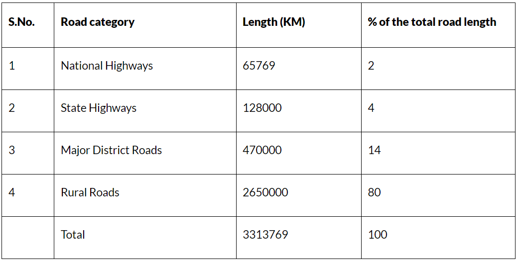
- Categorization of Roads:
- Roads in India are categorized into National Highways (NH), State Highways (SH), Major District Roads (MD), and Rural Roads (RR) for construction and maintenance purposes.
- This classification helps streamline the planning and development of roads based on their significance and regional connectivity.
Indian Road Network
National Highways (NH)
- National Highways (NH) as Principal Roadways:
- National Highways in India serve as the principal roadways constructed and maintained by the Central Government.
- Objectives of National Highways:
- These highways are designed for inter-state transportation, facilitating the movement of defense personnel and equipment in strategic locations.
- Connectivity of National Highways:
- National Highways play a crucial role in connecting various key locations, including state capitals, large cities, vital ports, and railway connections.
- Establishment of NHAI in 1995:
- In 1995, the National Highways Authority of India (NHAI) was established as a self-governing organization under the Ministry of Surface Transportation.
- NHAI Responsibilities:
- NHAI is responsible for the creation, maintenance, and operation of National Highways in India.
- It is the governing body dedicated to improving the standards of highways designated as National Highways.
- Golden Quadrilateral Project:
- The Golden Quadrilateral project is a significant initiative under NHAI, involving the construction of a 5,846-kilometre-long 4/6-lane, high-density traffic corridor.
- This corridor connects India's four major metropolises: Delhi, Mumbai, Chennai, and Kolkata.
Golden Quadrilateral
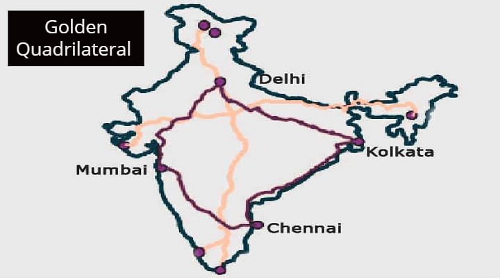
- Golden Quadrilateral (GQ) - Phase I:
- Phase I of the Golden Quadrilateral (GQ) aimed at connecting the four major cities of Delhi, Mumbai, Chennai, and Kolkata.
- The total length of this ambitious project is 5,846 km (3,633 mi).
- Funding Sources:
- The project received substantial funding from the government, primarily through special petroleum product tax revenues and government borrowing.
- Completion Announcement:
- In January 2012, India officially announced the completion of the four-lane Golden Quadrilateral highway network, marking a significant milestone in the country's infrastructure development.
North-South and East-West corridors
- Phase II: North-South and East-West Corridors:
- The second phase involved the development of the North-South and East-West corridors, comprising national highways connecting the four extreme points of the country.
- Corridor Length:
- The North-South and East-West Corridor (NS-EW) covered a substantial length of 7,300 km (4,500 mi).
- Geographical Coverage:
- The corridors connected Srinagar in the north to Kanyakumari in the south, including a spur from Salem to Kanyakumari (via Coimbatore and Kochi), and extended from Silchar in the east to Porbandar in the west.
- Project Status:
- As of April 2012, approximately 84.26% of the project had been completed, and ongoing work accounted for 15.7% of the project.
- Port Connectivity and Additional Projects:
- The project also encompassed port connectivity and other initiatives, spanning a distance of 1,157 km (719 mi).
- Overall Progress:
- The North-South and East-West Corridor project represented a comprehensive effort to enhance connectivity across the nation, contributing to the economic and infrastructural development of India.
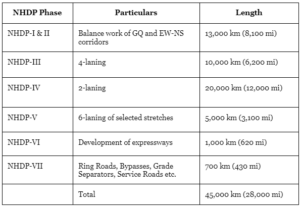
National Highways Development Project
Important National Highways are:
- NH 1: New Delhi – Ambala – Jalandhar – Amritsar.
- NH 2: Delhi – Mathura – Agara – Kanpur – Allahabad – Varanasi – Kolkata.
- NH 3: Agra – Gwalior – Nasik – Mumbai
- NH 4: Thane and Chennai via Pune and Belgaun.
- NH 5: Kolkata – Chennai
- NH 6: Kolkata – Dhule
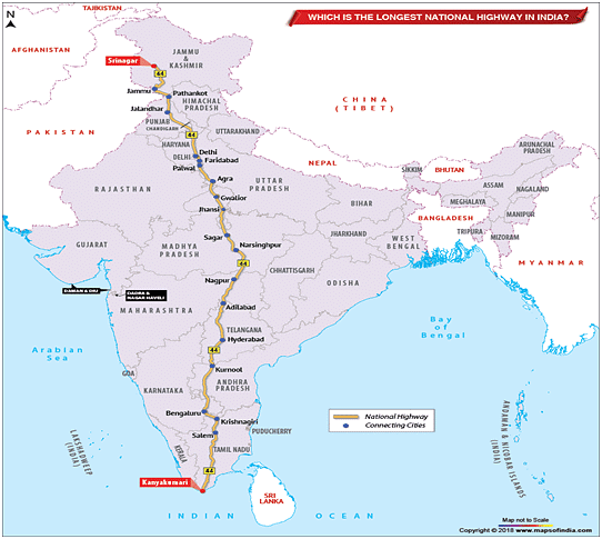
- NH 7: Varanasi – Kanyakumari
- NH 8: Delhi – Mumbai (via Jaipur, Baroda and Ahmedabad)
- NH 9: Mumbai – Vijaywada
- NH 10: Delhi – Fazilka
- NH 11: Agra – Bikaner
- NH 12: Jabalpur – Jaipur
- NH 24: Delhi – Lucknow
- NH 27: Allahabad – Varanasi
- NH 28: Barauni – Lucknow
- NH 29: Gorakhpur – Varanasi
- NH 56: Lucknow – Varanasi
- NH – 7 is the longest highway of India.
State Highways (SH)
State governments are responsible for the creation and maintenance of State Highways (SH). These highways serve to connect state capitals, district headquarters, and other major cities within a particular state.
- Integration with National Highway System:
- State Highways are interconnected with the National Highway System, ensuring a seamless network that spans both national and state levels.
- Contribution to Total Road Length:
- State Highways contribute to approximately 4% of the total road length in the country.
- While they constitute a smaller portion, their significance lies in facilitating intra-state transportation and regional connectivity.
Road density
- Definition of Road Density:
- Road density is defined as the ratio of the length of a country's total road network to its land area.
- The road network encompasses all types of roads, including motorways, highways, main or national roads, secondary or regional roads, and other urban and rural roads.
- Non-Uniform Distribution in India:
- The distribution of roads in India is not uniform, varying across regions and states.
- Regional Variances:
- Road density ranges from a mere 10.48 km in Jammu and Kashmir to a substantial 387.24 km in Kerala.
- The national average for road density in India is 75.42 km.
- Low Density in Specific Regions:
- Road density is notably low in specific regions, including the Himalayan region, Northeast region, and Rajasthan.
- These variations highlight the diverse topography and geographical challenges influencing road development in different parts of the country.
Railways in India
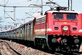
- Indian Railway System Overview:
- The Indian railway system is the largest in Asia and the fourth largest globally.
- It stands as the biggest departmental public undertaking in the country.
- Historical Milestones:
- The inaugural train journey in India took place between Bombay and Thane, covering a distance of 34 km, on April 16, 1853.
- The Indian Railways celebrated its 150th anniversary on April 16, 2003.
- Electric Train Introduction:
- The first electric train in India, named 'Deccan Queen,' commenced operations in 1929 between Bombay and Poona.
- Significant Statistics:
- Indian Railways boasts the second largest electrified system globally, following Russia.
- The Shatabadi Express holds the title of the fastest train in India, with a maximum speed of 140 km/hr.
- The total route covered by the railway system is approximately 63,000 km, with 7,100 railway stations.
- Longest Platform and Train Route:
- The longest railway platform in India is at Kharagpur (West Bengal).
- The longest train route is covered by the 'Himsagar Express' from Jammu Tavi to Kanyakumari, spanning 3,726 km through ten states.
- Metro Rail Introduction:
- The first Metro Rail was introduced in Kolkata (West Bengal) on October 24, 1984, connecting Dumdum and Belgachhia stations.
- Railway Gauges:
- Indian Railways operate on three different gauges: Broad Gauge (1.67 m), Metre Gauge (1.00 m), and Narrow Gauge (0.762 or 0.610 m).
- Broad gauge constitutes nearly 74% of the total route, followed by metre gauge at 21%, and the remaining by narrow gauge.
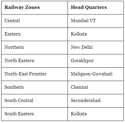
- Railway Zones:
- Northern Railway (NR) is the largest railway zone, covering a length of 10,995 km.
- North – East Frontier (NEF) is the smallest railway zone, with a route length of 3,860 km.
- Konkan Railways Project:
- The Konkan Railways India project aims to shorten the distance between Maharashtra, Goa, and Karnataka, spanning a total route length of 786 km from Roha (Maharashtra) to Mangalore (Karnataka).
Railway Manufacturing Units
- Chittaranjan Locomotive Works : Located in Chittaranjan (W.B) and manufactures electric engines.
- Diesel Locomotive Works : Located in Varanasi (U.P) and manufactures diesel engines.
- Integral Coach Factory in India : Located in Perambur (TN) and manufactures rail coaches.
- Wheel and Axle Plant : Located at Yalahanka (Bangalore, Karnataka) and manufactures wheels and axles.
- Diesel Component Works : Located at Patiala (Punjab) and manufactures components of diesel engines.
- Rail Coach Factory in India : Located at Kapurthala (Punjab) and manufactures rail coaches.
Major District Roads (MD)
- District Roads Overview:
- District Roads serve as crucial connecting links between District Headquarters and other important nodes within the district.
- Strategic Importance:
- These roads play a pivotal role in facilitating transportation and connectivity within districts, ensuring efficient travel between key locations.
- Contribution to Total Road Length:
- District Roads account for approximately 14% of the total road length in the country.
- Despite constituting a smaller percentage, their significance lies in their strategic role at the district level, supporting local mobility and accessibility.
Rural Roads (RR)
- Importance of Rural Roads:
- Rural roads are essential for connecting and ensuring accessibility to rural communities.
- Significant Contribution to Total Road Length:
- Rural roads make up a substantial portion, contributing to approximately 80% of India's total road length.
- Density Variation Across Regions:
- The density of rural roads exhibits variation across regions, influenced by the terrain's characteristics.
- Different geographical features impact the distribution and development of rural roads in various parts of the country.
Border Roads
- Establishment of the Border Road Organisation (BRO):
- The Border Road Organisation (BRO) was established in May 1960 with a dual objective: advancing economic growth and enhancing defense preparedness.
- Focus on Northern and North-Eastern Borders:
- The primary goal of the BRO is to ensure the quick and coordinated upgrading of critically important roads along the northern and north-eastern borders of the country.
- Diverse Construction Capabilities:
- The BRO is recognized as a world-class diversified construction firm with expertise in various areas.
- Apart from road construction and maintenance in strategically significant locations, the BRO is actively involved in snow clearance in high-altitude areas.
- Role in International Highways:
- International highways developed by the BRO serve as effective links, aiming to promote harmonious relationships with neighboring countries.
- These efforts contribute not only to national defense but also to fostering positive connections and cooperation at the international level.
|
1179 videos|2219 docs|849 tests
|
FAQs on Transport in India - 1 - Famous Books for UPSC Exam (Summary & Tests)
| 1. What is the importance of road transport in India? |  |
| 2. What is the Indian Road Network like? | |
| 3. What are National Highways (NH)? | |
| 4. Can you explain the Golden Quadrilateral project? | |
| 5. What are the North-South and East-West corridors? | |


Semester Notes
,Previous Year Questions with Solutions
,video lectures
,Objective type Questions
,Viva Questions
,Sample Paper
,Free
,study material
,Transport in India - 1 | Famous Books for UPSC Exam (Summary & Tests)
,Summary
,Transport in India - 1 | Famous Books for UPSC Exam (Summary & Tests)
,mock tests for examination
,ppt
,MCQs
,Exam
,past year papers
,Important questions
,practice quizzes
,Transport in India - 1 | Famous Books for UPSC Exam (Summary & Tests)
,Extra Questions
,shortcuts and tricks
,


Transport in India - 1 Free PDF Download
Importance of Transport in India - 1
Transport in India - 1 Notes
Transport in India - 1 UPSC Questions
Study Transport in India - 1 on the App
|
© EduRev
|
Education Revolution
|


|


