UPSC Mains Answer PYQ 2023: Geology Paper 1 (Section- A) | Geology Optional for UPSC PDF Download
Note :These sample answers provide a brief overview of the topic. You may add or reduce information as you see fit, depending on your understanding.
Section - A
Q1: Answer the following questions in about 150 words each: (10x5=50)
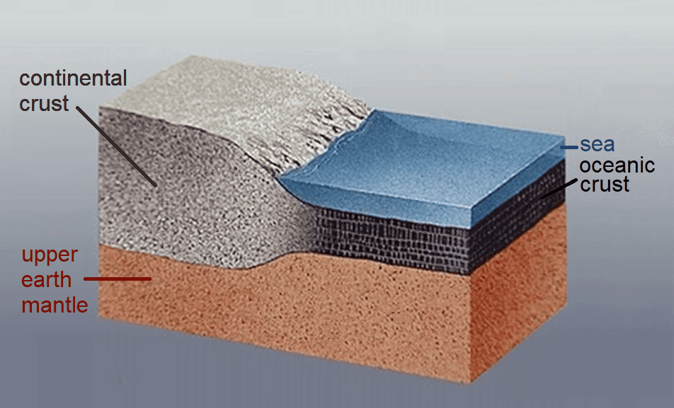
(a) Describe the tectonic features and evolution of the ‘continental crust’. (10 Marks)
Ans:
Introduction:
The continental crust is the outermost layer of the Earth's lithosphere and is primarily composed of granitic rocks. It forms the continents and is distinct from the oceanic crust, which is denser and predominantly composed of basaltic rocks. The evolution of continental crust is a complex process influenced by various geological forces.
Tectonic Features:
Shield Areas: These are ancient, stable regions of the continental crust characterized by low relief and extensive, often exposed, Precambrian rocks. Examples include the Canadian Shield and the Baltic Shield.
Platform Areas: These are relatively stable regions of the continental crust, often covered with a veneer of younger sedimentary rocks. They form the interior of continents and are tectonically less active compared to their margins.
Continental Margins: These are the boundaries between the continental crust and the oceanic crust. They can be passive or active. Passive margins are characterized by a lack of tectonic activity, while active margins are associated with tectonic plate boundaries and may experience earthquakes, volcanic activity, and mountain-building.

Evolution:
Accretion: The initial stages of continental crust formation involve the accretion of smaller landmasses and volcanic islands through processes like subduction and island arc formation.
Granite-Greenstone Belt Formation: Around 3 billion years ago, continental crust began to form through processes like partial melting and differentiation of basaltic magmas, leading to the formation of granite-greenstone belts.
Craton Stabilization: Over time, some portions of the continental crust stabilized and became the cores of continents, known as cratons. These cratons are characterized by ancient rocks and are often found in the interiors of continents.
Conclusion:
The evolution of continental crust is a dynamic process that spans billions of years. It involves a complex interplay of geological processes such as accretion, magmatism, metamorphism, and erosion. Understanding the tectonic features and evolution of continental crust provides valuable insights into the Earth's geological history.
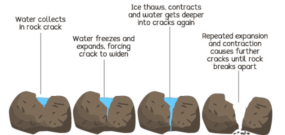
(b) Describe the physical and chemical weathering processes. (10 Marks)
Ans:
Introduction:
Weathering is the process by which rocks and minerals break down at or near the Earth's surface. It is a crucial step in the formation of soils and sedimentary rocks.
Physical Weathering:
Frost Wedging: Water enters cracks in rocks, freezes, and expands, causing the cracks to widen.
Exfoliation: Outer layers of rocks peel away due to pressure release, often in response to erosion or tectonic forces.
Abrasion: Rocks are physically worn down by the action of wind, water, or ice carrying particles.

Chemical Weathering:
Hydration: Minerals absorb water molecules, leading to expansion and weakening of the rock structure.
Oxidation: Minerals react with oxygen, causing changes in color and structure (e.g., rusting of iron-bearing minerals).
Carbonation: Carbon dioxide dissolves in water, forming carbonic acid that reacts with minerals like limestone, leading to their dissolution.

Conclusion:
Physical and chemical weathering are complementary processes that work together to break down rocks. The type and rate of weathering depend on factors such as climate, rock type, and mineral composition. These processes play a fundamental role in shaping landscapes and influencing the formation of sedimentary deposits.
(c) Describe the Spatial and Spectral resolution of a remote sensor with examples. (10 Marks)
Ans:
Introduction:
Remote sensing involves the collection of information about an object or area without physical contact. Resolution in remote sensing refers to the level of detail and clarity in the data collected.
Spatial Resolution:
- Spatial resolution refers to the size of the smallest discernible feature in an image. It is determined by the sensor's ground sample distance (GSD).
- Example: A satellite with a GSD of 1 meter can distinguish objects that are at least 1 meter apart on the Earth's surface.
Spectral Resolution:
- Spectral resolution refers to the ability of a sensor to capture specific wavelengths or bands of electromagnetic radiation.
- Example: Multispectral sensors capture data in several distinct bands (e.g., red, green, blue, infrared), while hyperspectral sensors capture a much larger number of narrow, contiguous bands.
Conclusion:
Spatial and spectral resolutions are crucial considerations in choosing remote sensing data for specific applications. Higher spatial resolution provides finer detail, while higher spectral resolution enables the discrimination of different surface materials and conditions.
(d) Briefly describe the Cataclasite and Pseudotachylite rocks. (10 Marks)
Ans:
Introduction:
Cataclasite and pseudotachylite are two types of rocks formed as a result of intense geological processes.
Cataclasite:
- Cataclasite is a type of breccia formed by the grinding and fracturing of rocks along fault zones.
- It is characterized by angular clasts in a finer-grained matrix, often formed by the mechanical breakdown of rocks during fault movement.
Pseudotachylite:
- Pseudotachylite is a type of rock that forms from the rapid solidification of molten material generated during seismic events.
- It is typically fine-grained and glassy in texture, resembling volcanic glass.
Conclusion:
Both cataclasite and pseudotachylite provide valuable insights into the geological processes associated with faulting and seismic activity. They serve as indicators of intense tectonic forces and can help reconstruct past seismic events.
(e) Discuss the differences between Symmetrical and Asymmetrical folds with the help of neat diagrams. (10 Marks)
Ans:
Introduction:
Folding is a common geological process where rocks deform due to compressional forces. Symmetrical and asymmetrical folds refer to the shape and orientation of the folded layers.
Symmetrical Folds:
- Symmetrical folds have limbs that are mirror images of each other with respect to the axial plane.
- They form under balanced compressional forces and are often found in more uniform, ductile rock layers.
Asymmetrical Folds:
- Asymmetrical folds have limbs that are not mirror images of each other.
- They form under unequal compressional forces, resulting in one limb being steeper than the other. This is common in rocks with varying resistance to deformation.

Conclusion:
Understanding the differences between symmetrical and asymmetrical folds provides insights into the geological history and tectonic forces that have shaped rock formations. These structures are key indicators of the complex processes that shape the Earth's crust.
Q2:
(a) Describe the types of radiometric dating techniques used to establish the age of the Earth. (20 Marks)
Ans:
Introduction:
Radiometric dating is a method used to determine the age of rocks and minerals by measuring the ratio of certain radioactive isotopes to their decay products. It provides crucial insights into the Earth's geological history.
Types of Radiometric Dating Techniques:
1. Uranium-Lead Dating:
- Principle: Uranium-238 (U-238) decays to lead-206 (Pb-206) with a known half-life.
- Example: Zircon crystals are commonly used for U-Pb dating, providing ages for some of the oldest rocks on Earth.
2. Potassium-Argon Dating:
- Principle: Potassium-40 (K-40) decays to argon-40 (Ar-40) with a known half-life.
- Example: This method is used for dating volcanic rocks, as potassium is abundant in them.
3. Carbon-14 Dating:
- Principle: Carbon-14 (C-14) is produced in the atmosphere and taken up by living organisms. It decays after death.
- Example: It is used to date organic materials up to around 50,000 years old.
4. Rubidium-Strontium Dating:
- Principle: Rubidium-87 (Rb-87) decays to strontium-87 (Sr-87) with a known half-life.
- Example: It is used for dating older rocks and minerals, particularly those with high rubidium content.
5. Luminescence Dating:
- Principle: This method measures the amount of trapped electrons in minerals, which accumulate over time due to exposure to natural radiation.
- Example: Quartz and feldspar grains in sediment are commonly used for luminescence dating.
Conclusion:
Radiometric dating techniques provide a powerful tool for establishing the ages of rocks and minerals, allowing geologists to reconstruct the Earth's history over millions to billions of years.
(b) Discuss the different types of interaction of electromagnetic radiation with the atmosphere of the earth and its impact on remote sensing images. (15 Marks)
Ans:
Introduction:
Electromagnetic radiation interacts with the Earth's atmosphere in various ways, affecting the quality of remote sensing images.
Types of Interaction:
1. Absorption:
- Certain wavelengths of radiation are absorbed by atmospheric gases. For example, water vapor, carbon dioxide, and ozone absorb specific bands of infrared radiation.
2. Scattering:
- Rayleigh Scattering: Occurs when shorter wavelengths (blue and violet) are scattered more than longer wavelengths (red and yellow). This is why the sky appears blue.
- Mie Scattering: Occurs when particles in the atmosphere (e.g., dust, water droplets) scatter all wavelengths equally. This can lead to haziness or reduced image clarity.
3. Reflection and Transmission:
- Some radiation is reflected back to space, while some penetrates the atmosphere and reaches the Earth's surface. This interaction affects the quality and accuracy of remote sensing data.
4. Emission:
- The atmosphere emits its own radiation, particularly in the thermal infrared range. This can interfere with the detection of features on the Earth's surface.
Impact on Remote Sensing:
- Atmospheric interference can reduce the accuracy of measurements and limit the effectiveness of certain sensors, especially in the thermal infrared region.
- Correction algorithms are applied to remote sensing data to mitigate the effects of atmospheric interference.
Conclusion:
Understanding the interactions of electromagnetic radiation with the atmosphere is crucial for accurate remote sensing applications. It allows scientists to correct for atmospheric effects and obtain reliable information about the Earth's surface.
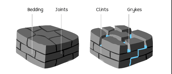
(c) What are joints ? Describe the Geometric and Genetic classification of joints with neat diagrams. (15 Marks)
Ans:
Introduction:
Joints are fractures in rocks along which there has been no significant movement parallel to the fracture surface. They play a significant role in the formation of landscapes and influence groundwater flow.
Geometric Classification:
1. Basic Types:
- Tensional Joints: Formed due to stretching forces. They are typically vertical or sub-vertical.
- Shear Joints: Formed due to horizontal shearing forces. They are often characterized by oblique orientations.
2. Arrangement:
- Columnar Joints: Formed in regular, often hexagonal patterns in igneous rocks as they cool and contract.
- Sheet Joints: Develop in response to unloading and exfoliation, resulting in parallel fractures.
Genetic Classification:
- Primary Joints: Formed during the cooling and solidification of molten rock. Example: Columnar joints in basalt.
- Secondary Joints: Formed after the rock has already been deposited, often due to tectonic forces or other geological processes. Example: Tensional joints in sedimentary rocks.
Conclusion:
Joints are crucial features in geology, influencing the behavior of rocks and groundwater. Understanding their geometric and genetic classifications aids in geological interpretation and resource exploration.
Q3:
(a) Elucidate the types of glacier and illustrate the erosional and depositional features produced by the valley-glaciers. (20 Marks)
Ans:
Introduction:
Glaciers are large, slow-moving masses of ice that play a significant role in shaping the Earth's landscape. They form in regions where snow accumulation exceeds melting and sublimation.
Types of Glacier:
Mountain Glaciers: Located in mountain ranges, these glaciers occupy valleys and are influenced by local topography.
Continental Glaciers (Ice Sheets): Cover large land areas and are found in polar regions. They are much larger and thicker than mountain glaciers.
Erosional Features:
Cirques: Bowl-shaped depressions at the head of a glacier where it originates.
Aretes and Horns: Aretes are sharp, narrow ridges between adjacent glacial valleys. Horns are pyramidal peaks formed by the erosion of cirques.
U-shaped Valleys: Characteristic of glacial erosion, they have steep, straight sides and a flat bottom.
Depositional Features:
1. Moraines:
- Accumulations of unconsolidated glacial debris (rock, sediment) carried and deposited by the glacier.
- Example: Terminal moraines mark the farthest extent of a glacier's advance.
2. Erratics:
- Large, isolated boulders transported and deposited by a glacier, often composed of rock types different from the local bedrock.
3. Drumlins:
- Elongated, streamlined hills of glacial till, formed by the deposition of material beneath a moving glacier.
Conclusion:
Valley glaciers and ice sheets have distinct erosional and depositional features that provide valuable information about their past behavior and the geology of the regions they have affected.
(b) Discuss the origin, composition and classification of meteorites. (15 Marks)
Ans:
Introduction:
Meteorites are remnants of extraterrestrial material that survive their passage through the Earth's atmosphere and land on the surface.
Origin:
1. Asteroidal Origin:
- Most meteorites originate from asteroids in the asteroid belt between Mars and Jupiter.
- They are fragments from collisions or disruptions of parent bodies.
2. Cometary Origin:
- Some meteorites, called carbonaceous chondrites, are believed to have originated from comets.
Composition:
1. Stony Meteorites (Chondrites):
- Composed mostly of silicate minerals with small amounts of metallic nickel-iron.
- They contain chondrules, which are small, spherical inclusions.
2. Stony-Iron Meteorites:
- Composed of roughly equal amounts of silicate material and nickel-iron alloy.
3. Iron Meteorites:
- Composed mostly of nickel-iron alloy.
Classification:
1. Chondrites:
- Most common type, containing chondrules.
- Subtypes include ordinary chondrites, carbonaceous chondrites, and enstatite chondrites.
2. Achondrites:
- Lacking chondrules, believed to have undergone partial melting.
- Subtypes include basaltic and non-basaltic achondrites.
3. Iron and Stony-Iron Meteorites:
- Classified based on the proportion of metal and silicate material.
Conclusion:
Meteorites provide crucial insights into the early solar system and the processes that shaped it. Their composition and classification help scientists understand the diversity of materials that formed planets and asteroids.
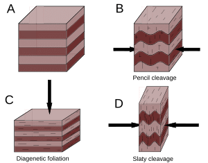
(c) What is a rock cleavage ? Describe the different types of rock cleavages with the help of neat diagrams. (15 Marks)
Ans:
Introduction:
Rock cleavage refers to the tendency of rocks to break along specific planes of weakness, often parallel to bedding or foliation.
Types of Rock Cleavage:

1. Slaty Cleavage:
- Characteristics: Very fine-grained, smooth surfaces, easily split into thin sheets.
- Example: Shale and slate exhibit slaty cleavage.
2. Schistosity:
- Characteristics: Coarser-grained than slaty cleavage, often wavy or curving surfaces.
- Example: Schist is a metamorphic rock with a prominent schistosity.
3. Gneissic Banding:
- Characteristics: Alternating layers or bands of light and dark minerals, often with a high degree of metamorphic alteration.
- Example: Gneiss is characterized by gneissic banding.
Diagrams: (Insert neat diagrams of slaty cleavage, schistosity, and gneissic banding)
Conclusion:
Rock cleavage is a significant structural feature that influences the behavior of rocks in response to stress. Understanding the types of cleavage aids in geological interpretation and engineering applications.
Q4:
(a) What is a Shear Zone ? Describe the different Shear Sense indicators. (20 Marks)
Ans:
Introduction:
A shear zone is a geological structure where rocks have experienced significant horizontal displacement due to shearing forces. They play a crucial role in the Earth's crustal deformation.
Shear Sense Indicators:
1. Crenulation Cleavage:
- Description: Small-scale, closely spaced folds and cleavages developed within a larger shear zone.
- Indicator of Shear Direction: The orientation of crenulations indicates the direction of shear.
2. S-C Structures (Shear Banding):
- Description: Layers of rock exhibiting a sigmoidal shape, indicating the direction of shear.
- Indicator of Shear Direction: The asymmetrical "S" shape points in the direction of shear.
3. Mineral Lineations:
- Description: Preferred orientation of elongated minerals, such as micas or feldspar, within the shear zone.
- Indicator of Shear Direction: The alignment of mineral grains reflects the direction of shear.
4. Flanking Lineations:
- Description: Linear features on the flanks of a fold or shear zone, indicating the direction of shear.
- Indicator of Shear Direction: The orientation of flanking lineations indicates the direction of shear.
5. Pressure Shadows:
- Description: Areas where hard or resistant minerals surround softer minerals, indicating the direction of shear.
- Indicator of Shear Direction: The asymmetrical shape of pressure shadows shows the direction of shear.
Conclusion:
Shear zones and their associated indicators provide valuable information about the tectonic history and deformational processes in a region. Understanding shear sense indicators helps geologists interpret the geological history of an area.
(b) Enumerate the Shepard’s classification of coast’s and briefly describe the marine cycle of erosion along. (15 Marks)
Ans:
Introduction:
Shepard's classification categorizes coastlines based on their geological and morphological features. The marine cycle of erosion describes the stages of coastal development.
Shepard’s Classification of Coasts:
1. Primary Coasts:
- Description: Coasts formed by non-marine processes such as volcanic activity or faulting.
- Example: Coastlines along divergent plate boundaries.
2. Secondary Coasts:
- Description: Coasts influenced by marine processes and landform modification.
- Example: Coastlines shaped by wave action and sediment deposition.
3. Tertiary Coasts:
- Description: Coasts undergoing further modification, often due to uplift or subsidence.
- Example: Coastlines experiencing tectonic movements and sea-level changes.
Marine Cycle of Erosion:
1. Wave-Cut Platform (Sub-Aerial Phase):
- Description: Flat, rocky surface formed by wave erosion at the high tide line.
- Example: The Jurassic Coast in England.
2. Cliff and Wave-Cut Notch (Sub-Aerial Phase):
- Description: Notch carved by wave action at the base of a cliff.
- Example: The White Cliffs of Dover.
3. Cave and Arch (Sub-Aerial Phase):
- Description: Cave formed by wave action, which may lead to the formation of an arch.
- Example: Durdle Door in England.
4. Stack and Stump (Sub-Aerial Phase):
- Description: Stack is a remnant of an eroded arch, while a stump is a small remaining section of a stack.
- Example: Old Harry Rocks in England.
Conclusion:
Shepard's classification provides a framework for understanding the diverse features and processes that shape coastlines. The marine cycle of erosion highlights the dynamic nature of coastal evolution.
(c) Describe the different types of volcanoes based on mode of the eruption and its associated products. Add a note on positive and negative relief features associated with volcanoes. (15 Marks)
Ans:
Introduction:
Volcanoes are geological features formed by the eruption of molten rock, ash, and gases from the Earth's interior.
Types of Volcanoes:
1. Shield Volcanoes:
- Description: Broad, gently sloping volcanoes formed by the accumulation of low-viscosity basaltic lava flows.
- Example: Mauna Loa in Hawaii.
2. Stratovolcanoes (Composite Volcanoes):
- Description: Steep-sided, symmetrical volcanoes composed of alternating layers of lava and pyroclastic deposits.
- Example: Mount St. Helens in the United States.
3. Cinder Cone Volcanoes:
- Description: Steep-sided, small volcanoes formed from pyroclastic fragments ejected during explosive eruptions.
- Example: Sunset Crater in Arizona, USA.
4. Calderas:
- Description: Large, circular depressions formed by the collapse of a volcano after a major eruption.
- Example: Yellowstone Caldera in Wyoming, USA.
Associated Products:
Lava Flows: Streams of molten rock that travel down the sides of a volcano.
Pyroclastic Deposits: Accumulations of ash, tephra, and other volcanic fragments ejected during eruptions.
Relief Features:
1. Positive Relief Features:
- Volcanic Domes: Steep-sided mounds formed from the slow extrusion of highly viscous lava.
- Lava Plateaus: Large, flat areas covered by extensive lava flows.
2. Negative Relief Features:
- Craters: Circular depressions at the summit of a volcano, often associated with active vents.
- Calderas: Large collapse features formed after a major eruption.
Conclusion:
Understanding the different types of volcanoes and their associated products provides insights into the geological processes occurring beneath the Earth's surface. Relief features associated with volcanoes offer valuable information about their formation and history.
|
64 videos|135 docs
|
FAQs on UPSC Mains Answer PYQ 2023: Geology Paper 1 (Section- A) - Geology Optional for UPSC
| 1. What are the main topics covered in the UPSC Geology Paper 1 exam? |  |
| 2. How can I effectively prepare for the UPSC Geology Paper 1 exam? |  |
| 3. What is the syllabus for the UPSC Geology Paper 1 exam? |  |
| 4. Are there any recommended books for the UPSC Geology Paper 1 exam preparation? |  |
| 5. What is the exam pattern for UPSC Geology Paper 1? |  |


