Geography: November 2023 Current Affairs | General Test Preparation for CUET UG - CUET Commerce PDF Download
Global Energy Monitor’s Global Coal Plant Tracker
Context
In its latest quarterly update, the Global Energy Monitor (GEM), a non-profit organization that compiles information on coal projects globally, has presented key findings on the current status of coal power projects around the world through its Global Coal Plant Tracker.
What are the Key Findings of the GEM Report?
- Global Coal Construction Trends:
- China leads the way in new coal plant construction, accounting for over 95% of the capacity initiated in 2023, underscoring its dominance in the sector.
- The global landscape shows a consecutive two-year decline in the establishment of new coal power capacity, signaling a widespread shift away from coal in various regions.
- Contemplated Coal Capacity:
- Across 32 countries, there are deliberations on 110 GW of coal power capacity, indicating a substantial number of coal projects are still in the consideration phase.
- India, Bangladesh, and Indonesia take the lead, constituting 83% of the proposed coal capacity outside of China.
- Project Status Trends:
- In the first nine months of 2023, 18.3 GW of coal capacity transitioned from proposed to either shelved or canceled status across multiple countries.
- Despite these setbacks, new proposals totaling 15.3 GW emerged in India, Indonesia, Kazakhstan, and Mongolia.
- As of July 2023, India, Indonesia, Bangladesh, and Vietnam collectively represent 84% of the 67 GW of coal power capacity under construction outside China.
- Indian Perspective:
- India aims to significantly boost coal-fired power plant capacity by 2032, targeting 80 GW compared to the previously outlined 27 GW in the National Electricity Plan 2022-32 (NEP).
- Certain states in India have witnessed progress in coal plant projects, with granted permits and reported advancements in Chhattisgarh, Gujarat, Jharkhand, Madhya Pradesh, Odisha, and Uttar Pradesh.
- Recommendations:
- In the face of global initiatives to address climate change, the report underscores the urgent necessity to halt the construction of new unabated coal power plants to effectively curb global warming.
What is Coal?
Overview
- Fossil fuel found in sedimentary rocks, commonly referred to as 'Black Gold.'
- Conventional energy source widely used for domestic heating, industrial applications (iron, steel, steam engines), and electricity generation (thermal power).
- Global Production:
- Major coal producers globally include China, US, Australia, Indonesia, and India.
Distribution in India
- Gondwana Coal Fields (250 million years old):
- Represents 98% of India's coal reserves and 99% of production.
- Located in Damodar, Mahanadi, Godavari, and Narmada valleys.
- Constitutes metallurgical-grade and high-quality coal.
- Tertiary Coal Fields (15 – 60 million years old):
- Low carbon content with high moisture and sulfur.
- Found in Assam, Meghalaya, Nagaland, Arunachal Pradesh, Jammu and Kashmir, Darjeeling foothills, Rajasthan, Uttar Pradesh, and Kerala.
- Classification:
- Anthracite (80 - 95% carbon content): Limited quantity in Jammu and Kashmir.
- Bituminous (60 - 80% carbon content): Found in Jharkhand, West Bengal, Odisha, Chhattisgarh, and Madhya Pradesh.
- Lignite (40 - 55% carbon content): High moisture; found in Rajasthan, Lakhimpur (Assam), and Tamil Nadu.
- Peat (less than 40% carbon content): Early stage of transformation from organic matter to coal.
Survival of Rainforests Around 50 Million Years Ago
Context
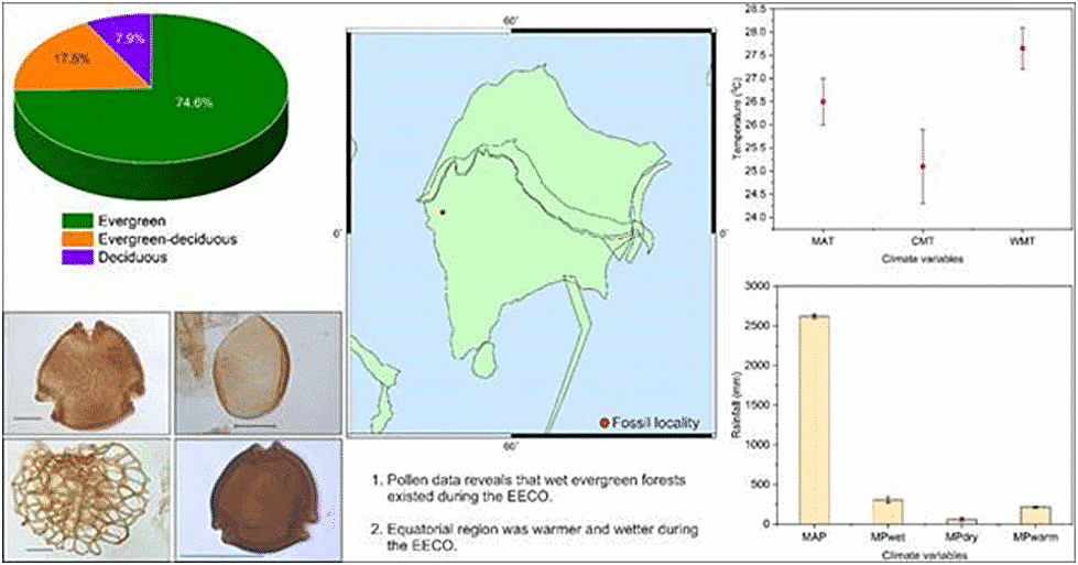
High rainfall helped the survival of equatorial rainforests at a time when Earth was globally warm and atmospheric carbon dioxide concentration was a whopping more than 1000 ppmv, around 50 million years ago.
Background
- The existing palaeo-climate data of mid- and high latitudes suggest large fluctuations in rainfall at around 50 million years ago.
- However, the quantification of terrestrial palaeoclimate data from the equatorial region was never attempted.
- Scientists are trying to explore the palaeoclimate data to probe the mysteries of survival under adverse conditions.
Paleoclimatic restructured simulations
- Paleoclimatology:
- The examination of Earth's climate history.
- Scientific Contribution - Birbal Sahni Institute of Palaeosciences (BSIP):
- Scientists at BSIP, a Department of Science and Technology autonomous institute, have quantified the equatorial climate from approximately 50 million years ago.
- Data Utilization:
- Utilizing plant proxies, the research aids in comprehending Earth's past climate and its connection to current and future conditions.
- Effects of High Rainfall:
- Estimated impact: High rainfall around 50 million years ago likely enhanced plant water use efficiency, providing resilience in coping with elevated carbon dioxide concentration and extreme warmth.
- Historical Global Climate:
- Previously acknowledged: Earth was approximately 13°C warmer than present, with carbon dioxide concentration exceeding 1000 ppmv during that period.
- Impact on Forests:
- Hydrological cycle changes adversely affected mid- and high-latitude forests, while equatorial forests demonstrated remarkable survival under extreme conditions.
Significance of study
- Low latitude regions forest study: The study has also helped focusing on developing a calibration file from the low-latitude regions which will be useful in the quantification of seasonal deep-time terrestrial climate.
- Blimatic and biotic changes: Tracing the mystery of the survival of the rainforests – the biodiversity hotspots of the world is the Key to understanding climatic and biotic changes occurring at present and in the future.
Analysis of Research
Geological Time Scale:
- Phanerozoic Eon – 543 mya - present
- Cenezoic Era – 65.5 mya - Present
- Paleogene Period - 5 mya – 23.0 mya
- Eocene Epoch – 55 mya – 34 mya - Early Eocene (56 million to 47.8 million years ago)
Forest presence:
- Equatorial Forest: Due to high rainfall 50 mya, resulted in presence of around 75% of such forests.
- Evergreen-Deciduous Forest: The Evergreen-deciduous forest presence is around 17.5% over the globe.
- Deciduous Forest: The deciduous forest comprises of 7.9% which majorly lies in the transition of lower to mid-latitude regions of the Earth.
Presence of India:
- India during this period was present near equator and was under the influence of equatorial type of climate.
Flood in Somalia
Context
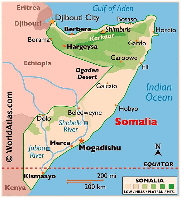
Severe flooding in Somalia, triggered by heavy seasonal downpours exacerbated by El Niño and the Indian Ocean Dipole, has been labelled a once-in-a-century event by the United Nations.
The heavy seasonal rainfall has been worsened due to the combined impact of two climate phenomenons, El Niño and the Indian Ocean Dipole (IOD), as per the UN Office for the Coordination of Humanitarian Affairs (UNOCHA).
- El Niños and a positive IOD are associated with above-normal rains and flooding in East Africa.
About Somalia
It is a country in the Horn of Africa. The country is bordered by Ethiopia to the west, Djibouti to the northwest, the Gulf of Aden to the north, the Indian Ocean to the east, and Kenya to the southwest. Somalia has the longest coastline on Africa’s mainland.
Countries called the Horn of Africa: SEED
- S- Somalia
- E- Ethiopia
- E- Eritrea
- D- Djibouti
Mount Etna
Why in News?
Mount Etna, Europe’s most active volcano and one of the largest in the world, has been erupting frequently since February 2023, sending plumes of ash and fountains of lava into the sky.
What are the Key Facts About Mount Etna?
- Mount Etna is a stratovolcano, which means it is composed of layers of lava, ash, and rocks that have accumulated over thousands of years of eruptions.
- It is located on the east coast of Sicily, an island in the Mediterranean Sea that belongs to Italy.
- It stands about 3,300 metres above sea level and covers an area of about 1,200 square kilometres.
- Mount Etna has four summit craters and hundreds of lateral vents that can produce different types of eruptions, such as explosive, effusive, or mixed.
- Mount Etna has been erupting almost continuously since 1500 BC, making it one of the most active volcanoes in the world.
Thousands of Earthquakes Rock Iceland
Context
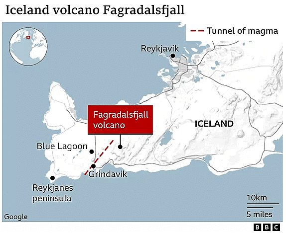
Iceland has declared a state of emergency following a series of 800 earthquakes that struck the southwestern Reykjanes peninsula in less than 14 hours.
- Approximately 1,400 earthquakes were detected in a day, and the peninsula has experienced over 24,000 seismic events since late October. The strongest of these earthquakes, with a magnitude of 5.2, occurred approximately 40 km from Reykjavík, Iceland's capital.
What is Happening in Iceland?
- About Iceland:
- Iceland is located on the Mid-Atlantic Ridge, technically the longest mountain range in the world, but on the floor of the Atlantic Ocean. The ridge separates the Eurasian and North American tectonic plates — making it a hotbed of seismic activity.
- The Mid-Atlantic Ridge is a divergent or constructive plate boundary where tectonic plates move away from each other, leading to the creation of new oceanic crust
- This geological setting makes the region prone to frequent earthquakes, with an annual average of approximately 26,000, as reported by Perlan, a natural history museum based in Reykjavik.
- While most of these tremors go unnoticed, the occurrence of earthquake swarms, characterized by numerous small earthquakes without a discernible mainshock, raises concerns about the possibility of an impending volcanic eruption.
- These earthquake swarms indicate heightened tectonic stress in specific areas.
- Notable Icelandic Volcanoes:
- Iceland boasts a total of 33 active volcanoes.
- Eyjafjallajökull, one of Iceland's most famous volcanoes, erupted in 2010, causing a widespread ash cloud.
- Other notable volcanoes include Hekla, Grímsvötn, Hóluhraun, and Litli-Hrútur, part of the Fagradalsfjall system.
How are Earthquake Swarms a Sign of Volcanic Activity?
- Magma Formation and Movement:
- Intense heat beneath the Earth's surface melts rocks, giving rise to magma, a flowing substance lighter than solid rock.
- The buoyancy of magma propels it upwards, with most of it being confined to magma chambers deep underground.
- Volcanic Eruptions:
- While the majority of magma cools and solidifies over time, a fraction erupts through vents and fissures on the Earth's surface.
- These eruptions are the visible outcomes of the geological processes occurring beneath the surface.
- Earthquake Swarms as Indicators:
- The movement of magma near the Earth's surface exerts force on surrounding rock layers.
- This force often leads to the occurrence of earthquake swarms, clusters of seismic activity in a particular region.
- Proximity to Eruption:
- Magma movement underground doesn't always culminate in a volcanic eruption.
- The closer magma gets to the Earth's surface, the higher the likelihood of an eruption, accompanied by more frequent and symptomatic earthquake swarms.
Rainfall Deficiency in Southern Peninsular India
Context
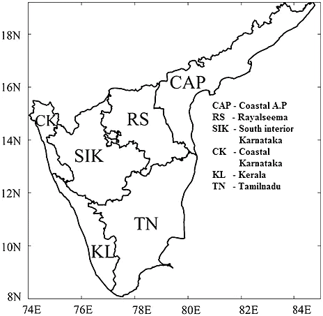
The India Meteorological Department (IMD) recent analysis regarding the rainfall patterns in Southern peninsular India, spanning 123 years of records, exposed that the region encountered its sixth driest October in its meteorological history.
What are the Major Factors Influencing Rainfall Deficiency in Southern Peninsular India?
- About:
- The Southern Peninsular region encompassing Kerala, Mahe, South Interior Karnataka, Tamil Nadu, Karaikal, Puducherry, coastal Andhra Pradesh, Yanam and Rayalaseema received only 74.9mm of rain in October, which was over 60% below normal.
- Factors Influencing Rainfall Deficiency:
- Confluence of Northeast Monsoon and Cyclone Hamoon: The commencement of the northeast monsoon coincided with the genesis of Cyclone Hamoon, causing a diversion of moisture away from southern peninsular India.
- This altered wind flow patterns and weakened the onset of the northeast monsoon.
- El Nino and Indian Ocean Dipole (IOD): 2023 is an El Nino year combined with a positive phase of the Indian Ocean Dipole (IOD).
- In such conditions, there is less rainfall over northern Tamil Nadu and adjoining areas.
- Whereas, the southernmost areas of Tamil Nadu and Kerala receive good rainfall in October.
Subansiri Lower Hydroelectric Project
Context
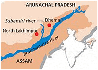
The Subansiri Lower Hydroelectric Project, India’s largest hydel project under construction, faced a setback when a landslide blocked the only functional diversion tunnel and stopped the flow of water downstream of the dam into the Subansiri River, a major tributary of the Brahmaputra.
- This resulted in the river bed drying up and endangering aquatic life. The incident also raised questions about the safety and viability of the project, which has faced multiple delays and opposition since its inception in 2005.
What is the Subansiri Lower Hydroelectric Project?
- Subansiri Lower Hydroelectric Project Overview:
- A run-of-river initiative aiming to produce 2,000 MW of power by tapping into the Subansiri River, situated on the Arunachal Pradesh-Assam border.
- Run-of-River Dam Definition:
- Involves a dam design where downstream water flow matches upstream flow, emphasizing continuous river flow.
- Executing Agency:
- The National Hydroelectric Power Corporation (NHPC) is responsible for implementing the project.
- Project Components:
- Features a 116-meter-high concrete gravity dam, a 34.5-km reservoir, five diversion tunnels, eight spillways, and a powerhouse with eight 250-MW units.
- Gravity Dam Definition:
- Constructed using concrete, it relies on its weight to withstand horizontal water pressure, holding back water effectively.
- Power Generation Estimate:
- Anticipated annual power generation of approximately 7,500 million units during a 90% dependable year.
- Additional Benefits:
- Expected to offer flood moderation, irrigation, and drinking water advantages to downstream regions.
- Construction History:
- NHPC Limited initiated construction in January 2005, facing interruptions from December 2011 to October 2019 due to local protests. Resumed on October 15, 2019, following National Green Tribunal clearance.
|
164 videos|798 docs|1153 tests
|
FAQs on Geography: November 2023 Current Affairs - General Test Preparation for CUET UG - CUET Commerce
| 1. What is the Global Coal Plant Tracker? |  |
| 2. How did rainforests survive around 50 million years ago? |  |
| 3. What caused the flood in Somalia? |  |
| 4. What is Mount Etna? |  |
| 5. Why does Iceland experience thousands of earthquakes? |  |


