Short & Long Question Answers: Locating Places on the Earth

Short Question Answers
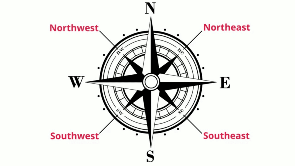
Q1: What are cardinal and intermediate directions?
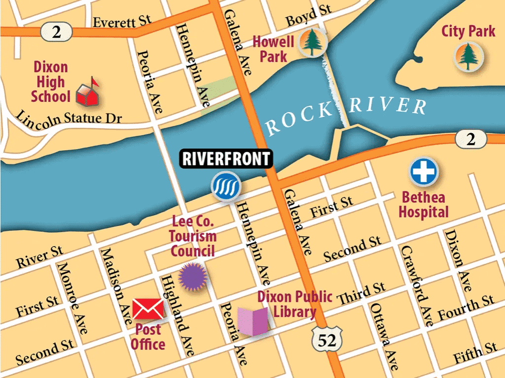
Ans: Cardinal directions are the four main directions on a map: north, east, south, and west. They are shown by arrows, with north usually at the top, as in the small city map .
Intermediate directions are in-between points: northeast (NE), southeast (SE), southwest (SW), and northwest (NW). These help us locate places more precisely.
For example, if the museum is southeast of the bank, it's between south and east from that point. Cardinal and intermediate directions guide us when navigating maps, ensuring we know which way to go based on the "N" arrow pointing north.
 Cardinal and Intermediate Directions
Q2: What is the difference between a map and a globe?
Ans: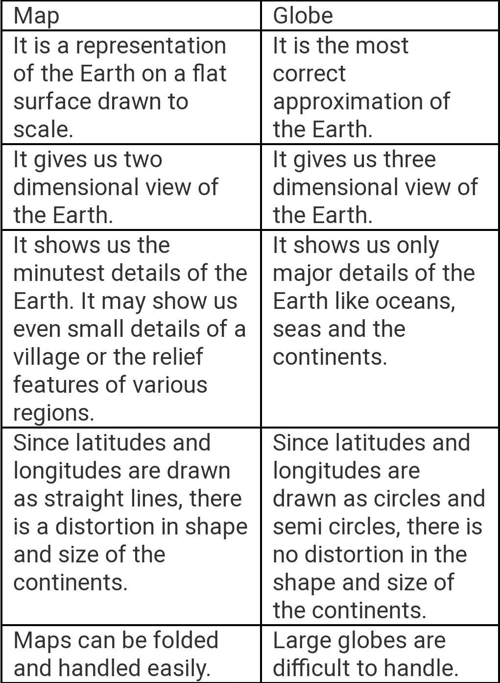
Q3: What are parallels of latitude?
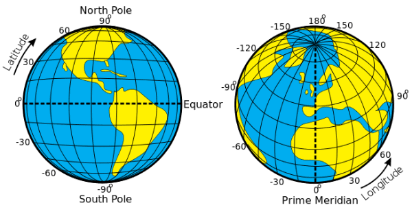
Ans: Parallels of latitude are imaginary lines running east to west around the Earth, parallel to the Equator. The Equator is at 0° latitude, while the North and South Poles are at 90°N and 90°S. These lines measure distance from the Equator in degrees. The Equator is the largest circle, and parallels get smaller toward the poles. Latitude affects climate-hot near the Equator, temperate farther away, and cold near the poles. On a globe, these lines help locate places north or south of the Equator accurately.
Q4: What are meridians of longitude?
Ans: Meridians of longitude are imaginary half-circles running from the North Pole to the South Pole. They measure distance east or west from the Prime Meridian (0° longitude) up to 180°. For example, Delhi is at 77°E, and New York is at 74°W. Unlike parallels, all meridians are the same length. They help locate places and determine local time, since the Earth spins 15° per hour. The Prime Meridian, passing through Greenwich, is the starting point for measuring longitude globally.
Q5: How do latitude and longitude help locate places?
Ans: Latitude and longitude together form a grid of coordinates to pinpoint any place on Earth.
- Latitude measures distance north or south of the Equator (0° to 90°N or S), while longitude measures east or west of the Prime Meridian (0° to 180°E or W).
- For example, Delhi is at 29°N and 77°E, as noted in the text. On a globe, these lines intersect, creating a unique spot for every location. This system, like a chessboard's coordinates, ensures precise navigation and mapping worldwide.
Q6: What is the Prime Meridian and why is it important?
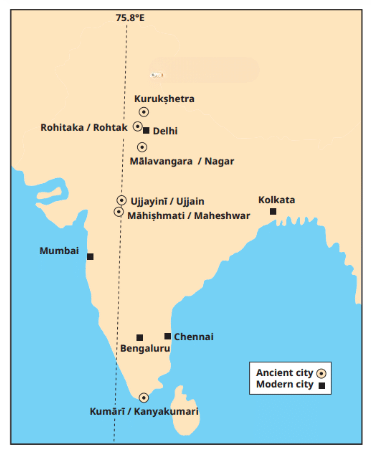
Ans: The Prime Meridian is the 0° longitude line, passing through Greenwich, England, set as the global standard in 1884. It divides the Earth into Eastern and Western Hemispheres. It's important because it's the reference point for measuring longitude and time worldwide. For example, Delhi at 77°E is east of it, and New York at 74°W is west. Time zones are based on it-15° east adds an hour to Greenwich Mean Time (GMT). It helps standardize location and time globally, unlike India's ancient Ujjayini meridian.
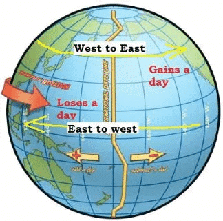
Q7: What is the International Date Line?
Ans: The International Date Line is an imaginary line at about 180° longitude, opposite the Prime Meridian. Crossing it changes the date: eastward subtracts a day (Monday to Sunday), westward adds a day (Sunday to Monday). It's not perfectly straight, bending to avoid splitting countries into two days. It works with time zones, where +12 and -12 hours meet. This line ensures the world's dates align as the Earth spins, making global travel and communication smoother.
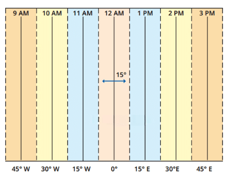
Q8: What are time zones and why do they exist?
Ans: Time zones are regions where the same standard time is used, based on meridians 15° apart (1 hour). The Earth spins 360° in 24 hours, so 15° equals 1 hour from GMT.
- They exist because local time varies with longitude, making it impractical for countries to use many local times. Time zone lines bend around borders for convenience.
- Large countries like Russia (11 zones) need multiple zones, while India uses one (IST). Time zones keep time consistent within regions.
Q9: Why does India have one standard time?
Ans: India uses one standard time, Indian Standard Time (IST), 5.5 hours ahead of GMT, despite stretching from 68°E to 97°E (29° longitude). This is because having multiple local times would be confusing in daily life, like travel or communication. Unlike larger countries like Russia with 11 time zones, India's size allows one time zone. The standard meridian is chosen centrally, and IST unifies the country. This ensures everyone follows the same clock, despite local time differences, like between Porbandar and Tinsukia.
Q10: What was the Ujjayini meridian in ancient India?
Ans: The Ujjayini meridian, or madhya rekha, was ancient India's prime meridian, passing through Ujjain, a key astronomy center 1,500 years ago . Used before the Greenwich Meridian, it was a reference for longitude in Indian astronomical texts, as noted by Varahamihira. Cities like Thanjavur were linked to it, though exact measurements were less precise due to limited timekeeping. It shows India's early understanding of coordinates, later replaced by the global standard at Greenwich in 1884, highlighting its historical role in mapping.
Long Question Answers
Q1: Explain how maps help us understand and navigate the Earth, including their components.
Ans: A map is a flat representation of an area, like a city or the Earth, viewed from above.
- Purpose: Maps help us find places and navigate, e.g., locating the bank from the railway station or the market, making them practical tools.
- Component 1: Distance (Scale): Scale shrinks real distances onto paper, e.g., 1 cm = 500 m or 2.5 cm = 500 km letting us calculate real distances.
- Component 2: Direction: Cardinal directions (north, east, south, west) and intermediate ones (NE, SE) are shown by arrows, with "N" at the top, guiding navigation.
- Component 3: Symbols: Symbols like lines for roads or shapes for temples represent features, saving space and making maps clear, standardized by the Survey of India.
- Types of Maps: Physical maps show natural features (mountains), political maps show boundaries (India's states), and thematic maps focus on specific info, enhancing understanding.
- Navigation Example: Using the small city map, you can plan a route from the station to the museum, using scale for distance, arrows for direction, and symbols for landmarks.
- Broader Use: Maps represent large areas like India, helping us study geography and locate places with precision, unlike a globe, which is less portable.
Q2: Describe the system of coordinates (latitude and longitude) and how it locates places on Earth.
Ans: Coordinates Defined: Latitude and longitude are a grid system to locate any place on Earth, like a chessboard's a-h and 1-8 labels.
- Latitude: Lines run east-west, parallel to the Equator (0°), up to 90°N (North Pole) and 90°S (South Pole), measuring north-south distance.
- Longitude: Half-circles run north-south from pole to pole, starting at the Prime Meridian (0°) to 180°E or W, measuring east-west distance.
- How They Work Together: They intersect to form a unique spot, e.g., Delhi at 29°N, 77°E, pinpointing exact locations on a globe or map.
- Latitude's Role: Affects climate-hot at 0°, temperate at mid-latitudes, cold near poles, helping us understand a place's environment.
- Longitude's Role: Determines local time, with 15° equaling 1 hour from GMT, linking position to time zones.
- Example: Mumbai's approximate coordinates (from an atlas) could be found, showing how this system applies practically.
- Historical Context: India's Ujjayini meridian was an early version, proving the concept's ancient roots before Greenwich standardization.
Q3: Discuss the relationship between longitude and time, including time zones and the International Date Line.
Ans: Earth's Rotation: The Earth spins 360° in 24 hours, so 15° of longitude equals 1 hour, as it rotates west to east.
- Longitude and Local Time: From the Prime Meridian (0°), time increases eastward (e.g., 15°E = +1 hour) and decreases westward (15°W = -1 hour).
- Time Zones: These are 15°-wide zones with a standard time, e.g., IST at +5.5 hours from GMT, simplifying time across countries.
- Variations: Lines bend around borders, and large countries like Russia have multiple zones (11), unlike India's single IST.
- International Date Line: At ~180°, it adjusts dates-crossing east subtracts a day, west adds one, avoiding day splits in countries .
- Example: If it's noon at Greenwich, it's 5:30 pm IST (77°E), showing longitude's time impact.
- Practical Case: Porbandar and Tinsukia's local time differs by ~2 hours (30°), but IST unifies them, highlighting local vs. standard time.
Q4: Compare local time and standard time, using examples .
Ans: Local Time Defined: Time based on a place's longitude, changing 1 hour per 15°, e.g., Porbandar (west) vs. Tinsukia (east) differ by ~2 hours.
- Standard Time Defined: A uniform time for a region, like IST (+5.5 hours from GMT), used across India despite longitude spans (68°E-97°E).
- Difference: Local time varies continuously with longitude; standard time is fixed for convenience, ignoring small variations.
- Example 1: In Porbandar, the sun sets later than in Tinsukia due to a 30° gap, but both use IST, so clocks match despite daylight differences.
- Example 2: At 12 pm GMT, local time at 15°E is 1 pm, but a country's standard time might align differently based on its chosen meridian.
- Purpose: Standard time avoids confusion in large areas, unlike local time, which reflects true solar position.
- Advantage: IST simplifies life in India; without it, every town would have a different clock, disrupting schedules.
- Conclusion: Local time is geographically accurate, but standard time prioritizes unity and ease, balancing science and practicality.
FAQs on Short & Long Question Answers: Locating Places on the Earth
| 1. What are the different ways to locate places on Earth using latitude and longitude? |  |
| 2. How do I find the difference between the equator and the Prime Meridian for my Social Studies exam? | |
| 3. What's the actual difference between heat zones and climate zones when locating places on Earth? | |
| 4. Why do we need to understand global positioning and coordinate systems for Class 6 Social Studies? | |
| 5. How can I memorise all the parallels and meridians for my CBSE exams easily? | |


