
Best Study Material for Class 6 Exam
Class 6 Exam > Class 6 Notes > Sample Papers For Class 6 > Class 6 Social Science : Sample Paper Solutions - 3
Class 6 Social Science : Sample Paper Solutions - 3 | Sample Papers For Class 6 PDF Download
Time: 2½ hrs
Total Marks: 80
General Instructions:
- The question paper consists of 34 questions and is divided into four sections: A, B, C, and D.
- All questions are compulsory.
- Section A comprises question numbers 1 to 15. These are multiple-choice questions carrying one mark each. You are to select one most appropriate response out of the four provided options.
- Section B comprises question numbers 16 to 22. These are short-answer questions carrying two marks each.
- Section C comprises question numbers 23 to 31. These are short-answer questions carrying four marks each.
- Section D comprises question numbers 32 to 34. These are short-answer questions carrying five marks each.
SECTION A
Q1: Which statement about the Ujjayini meridian is incorrect? (1 Mark)
a) It served as a reference for ancient Indian astronomical calculations
b) It passed through Ujjain, a key center for astronomy
c) It was internationally adopted in 1884, replacing Greenwich
d) It was called the "madhya rekha" or "middle line"
Ans: c
The Ujjayini meridian was an ancient Indian reference through Ujjain, not adopted globally in 1884—that was Greenwich, making c false.
Q2: What is a common feature of festivals like Makara Sankrānti, celebrated across India under different names? (1 Mark)
a) They mark the end of the monsoon season
b) They are linked to the harvest season
c) They celebrate military victories
d) They occur only in northern India
Ans: b
Makara Sankrānti and similar festivals (e.g., Pongal) mark the harvest around January, not monsoons, victories, or just the north.
Q3: What is the primary purpose of urban local bodies? (1 Mark)
a) To provide national security
b) To decentralize governance in urban areas
c) To enforce religious practices
d) To centralize economic power
Ans: b
Urban local bodies devolve power to city residents for local management, not security, religion, or centralization.
Q4: Why are some mountains still growing in height today? (1 Mark)
a) Erosion keeps reshaping their peaks upward
b) Snow accumulation adds to their elevation
c) Upliftment processes continue to push them higher
d) Volcanic activity deposits new layers on them
Ans: c
Tectonic uplift (e.g., Himalayas) raises mountains, countering erosion, unlike snow or volcanic buildup alone.
Q5: Which crop did the Harappans grow first in Eurasia? (1 Mark)
a) Wheat
b) Rice
c) Cotton
d) Barley
Ans: c
Harappans pioneered cotton cultivation in Eurasia, weaving it for trade, predating widespread rice or others.
Q6: What does the concept "separation of powers" ensure in a democracy?(1 Mark)
a) That all powers are held by the judiciary
b) That no branch of government has excessive power
c) That the legislature can make decisions alone
d) That the executive branch controls the judiciary
Ans: b
Separation balances legislature, executive, and judiciary, preventing any single branch’s dominance.
Q7: Which hemisphere contains a greater proportion of water compared to land? (1 Mark)
a) Northern Hemisphere, due to its larger oceans
b) Southern Hemisphere, as it has more ocean coverage
c) Both hemispheres have equal water and land distribution
d) Northern Hemisphere, because of its larger continents
Ans: b
The Southern Hemisphere has more ocean (e.g., Southern Ocean) than land, unlike the land-heavy North.
Q8: Why is there no "year zero" in the Gregorian calendar, and how does this affect calculating time between BCE and CE dates? (1 Mark)
a) It simplifies counting centuries; subtract 1 when adding BCE and CE years
b) It aligns with lunar cycles; add 1 to all calculations
c) It marks a leap year; no adjustment is needed
d) It reflects ancient traditions; multiply years by 2
Ans: a
The Gregorian skips from 1 BCE to 1 CE; adding BCE and CE years (e.g., 2 BCE to 2 CE = 3 years) requires subtracting 1.
Q9: What defines a joint family?
a) Parents and children living alone
b) Grandparents living with their children’s families
c) A single adult living with children
d) Unrelated individuals sharing a house
Ans: b
A joint family spans generations (e.g., grandparents, parents, kids) under one roof, unlike nuclear or unrelated setups.
Q10: Which concept from the Upaniṣhads connects the individual self to the universal divine essence, suggesting everything is interdependent?
a) Ahimsa
b) Ātman
c) Anekāntavāda
d) Aparigraha
Ans: b
Ātman (self) links to brahman (universal essence) in the Upaniṣhads, showing interdependence, unlike Jain-specific terms.
Q11: How can the number of continents vary between four and seven? (1 Mark)
a) Some continents are too small to count consistently
b) North and South America, and Europe and Asia, can be combined or separated based on perspective
c) Islands are sometimes included as continents
d) Oceans occasionally submerge parts of continents
Ans: b
Combining Americas or Eurasia reduces the count (e.g., 4); separating them gives 7, based on cultural/geographic views.
Q12: What role does the Gram Sabha play in the Panchayati Raj system?
a) It handles foreign policies
b) It is a gathering where villagers discuss and make decisions
c) It only supports financial decisions
d) It is a ceremonial body without real power
Ans: b
The Gram Sabha, comprising all village adults, debates and decides local issues, not just finances or foreign matters.
Q13: Why are non-economic activities considered valuable?
a) They generate large profits
b) They contribute to personal and community well-being
c) They require less time and effort
d) They are mandated by law
Ans: b
Non-economic acts (e.g., volunteering) enhance well-being and community, not profit or legal mandates.
Q14: Which traditional Indian garment exemplifies both a shared cultural practice and a range of regional styles and materials?
a) Dhoti
b) Sari
c) Kurta
d) Sherwani
Ans: b
The sari’s universal form varies by region (e.g., Banarasi silk), showing unity in diversity, unlike other garments.
Q15: What mechanism allows citizens in urban areas to participate in governance?
a) Mandatory military service
b) Compulsory voting
c) Committees and public meetings
d) State-level elections only
Ans: c
Ward committees and meetings enable urban citizens to engage directly in local governance, beyond voting or state elections.
SECTION B
Q16: How do families share work? (2 Marks)
Ans: Families share work by dividing tasks based on roles—parents earn money, kids study or help with chores, and elders cook or guide with wisdom. For example, a mother might cook while a grandfather tells stories to teach values. This teamwork keeps the family running smoothly. It’s a way everyone contributes to daily life, making sure all needs are met.
Q17: What is the Equator’s role on Earth? (2 Marks)
Ans: The Equator is the 0° latitude line splitting Earth into Northern and Southern Hemispheres, balancing day and night throughout the year. It marks the start of tropical zones, like India’s hot south, where seasons stay warm. Sailors long ago used it to find their way across oceans. It’s key to understanding Earth’s climate and navigation patterns.
Q18: What was unique about Harappan streets? (2 Marks)
Ans: Harappan streets were straight and crossed at right angles, forming a neat grid unlike the winding paths of other old towns. This careful planning, seen in cities like Mohenjo-Daro, made moving around easier. It showed their advanced design skills, setting them apart 4,500 years ago. Such order helped with trade and city life.
Q19: Why are deserts dry despite rivers nearby? (2 Marks)
Ans: Deserts stay dry because they get very little rain, even if rivers like the Indus flow nearby, as winds blow moisture away fast. The Thar Desert in India, for example, remains arid despite the river’s presence. High heat evaporates water quickly too. This dryness shapes how people live there, relying on wells or camels.
Q20: Why are Jataka Tales important? (2 Marks)
Ans: Jataka Tales are important because they share Buddhist stories about kindness and wisdom from Buddha’s past lives, told in a simple, fun way. For instance, a tale of a generous deer teaches helping others. They spread moral values across India and beyond. These stories connect people to ancient lessons still useful today.
Q21: How does the Bay of Bengal affect India? (2 Marks)
Ans: The Bay of Bengal brings monsoon rains to eastern India, watering crops like rice in states like Odisha, but it also causes floods that can ruin homes. It’s a trade route too, linking ports like Kolkata to other countries. Its warm waters shape India’s wet climate. This mix of help and harm affects millions yearly.
Q22: Why is it 5:30 pm in India when it is 12 pm or noon. in London? (2 Marks)
Ans: It is 5.30 pm in India when it is 12 pm or noon in London because:
London is located at 0° longitude, (the Prime meridian).
In India 82%°E longitude is standard meridian and time on this meridian is standard time in India (1ST).
Time in India is ahead of London. Time difference is 4 minutes for every 1° of longitude towards east.
Hence in India – 82 ½° ÷ 4 minutes
= 330 minutes
i.e. 330 ÷ 60 = 5 hours 30 minutes.
SECTION C
Q23:
(i) What is the Rigveda about?
(ii) How does it shape rituals? (4 Marks)
Ans:
(i) The Rigveda, the oldest Veda, is a collection of over 1,000 hymns written in Sanskrit over 3,000 years ago, praising gods like Agni (fire) and Indra (rain). It’s one of India’s earliest sacred texts, memorized by priests long before writing.
(ii) It shapes rituals by providing chants and rules for fire sacrifices, like the homa, still performed in weddings and prayers today. These hymns guide how people worship, linking them to nature and gods. For example, a bridegroom might recite its verses for blessings. This keeps ancient traditions alive in modern India, showing the Rigveda’s lasting role in culture.
Q24:
(i) What is a meridian?
(ii) How is it different from a parallel? (4 Marks)
Ans:
(i) A meridian is a vertical line of longitude stretching from the North Pole to the South Pole, used to measure how far east or west a place is from the Prime Meridian at 0°. It helps locate spots like Delhi at 77°E.
(ii) It differs from a parallel, which is a horizontal line of latitude, like the Equator at 0°, measuring north-south distance. Meridians curve and meet at the poles, while parallels stay apart and never touch. For instance, meridians narrow at the top, but parallels keep the same width, making them unique tools for mapping Earth.
Q25:
(i) How are plains formed by rivers?
(ii) Name one such plain in India. (4 Marks)
Ans:
(i) Plains are formed when rivers carry sediment like sand, silt, and mud, depositing it over thousands of years as they flow and flood. This flattens the land, creating wide, fertile areas perfect for farming and living. The process is slow but steady, shaping Earth’s surface.
(ii) The Ganga Plain in India is a major example, stretching across states like Uttar Pradesh and Bihar. It’s fed by the Ganga River’s deposits, growing crops like wheat and rice for millions. This plain’s richness supports huge populations and cities, making it a vital part of India’s geography.
Q26:
(i) What were Harappan docks?
(ii) Why were they built? (4 Marks)
Ans:
(i) Harappan docks were large, brick-lined water basins found at Lothal, likely used as ports where ships could load and unload goods. They were built about 4,500 years ago near the Sabarmati River’s mouth.
(ii) They were built to support trade with far-off lands like Mesopotamia, where Harappans sent cotton and beads. These docks show they were skilled sailors and traders, managing boats in a planned way. Their size suggests big ships docked there, proving the Harappans’ advanced economy and sea connections, linking India to the ancient world.
Q27:
(i) What is Asia’s largest desert?
(ii) How does it affect the continent? (4 Marks)
Ans:
(i) Asia’s largest desert is the Gobi, spanning Mongolia and northern China, a cold, rocky expanse unlike hot, sandy deserts like the Thar. It covers over a million square kilometers, harsh and vast.
(ii) It affects Asia by blocking rain, leaving nearby areas dry as winds can’t carry moisture past it, and its cold winds chill northern China’s winters. This limits farming, forcing people to herd animals instead. The Gobi’s size and climate shape how life survives in that part of the continent, making it a tough but unique region.
Q28:
(i) How do dances show India’s diversity?
(ii) Name one dance from the northeast. (4 Marks)
Ans:
(i) Dances show India’s diversity through unique styles reflecting local tales and traditions, like Bharatanatyam’s graceful moves in the south or Kathak’s fast spins in the north. Each region adds its own music and costumes, celebrating its culture.
(ii) Bihu from Assam in the northeast is a lively dance tied to the harvest, with fast steps and bright clothes showing joy and community spirit. It’s different from southern or western dances, proving India’s rich mix. These dances unite people by sharing their differences in festivals and gatherings.
Q29:
(i) What is the Western Ghats’ role?
(ii) How does it influence rain? (4 Marks)
Ans:
(i) The Western Ghats are a tall mountain range along India’s west coast, from Gujarat to Kerala, blocking winds and hosting thick forests full of wildlife like tigers. They’re a key natural feature shaping the south.
(ii) They influence rain by trapping monsoon clouds from the Arabian Sea, dumping heavy rain on the western side, like in Kerala, while leaving the eastern side, like Tamil Nadu, drier. This creates wet forests in the west and dry plains in the east. Farmers depend on this rain pattern for crops like tea, showing how the Ghats control weather and life.
Q30:
(i) What are monuments as sources?
(ii) Give an example from India. (4 Marks)
Ans:
(i) Monuments are structures like tombs, temples, or towers built long ago, showing how people lived, worshipped, or ruled. They’re physical clues to history, made of stone or brick, lasting centuries.
(ii) The Sanchi Stupa in India, built by Emperor Ashoka, is an example, with its dome and carvings telling Buddhist stories. It stands in Madhya Pradesh, showing ancient art and faith. Historians study it to learn about Ashoka’s time, making it a window to India’s past still visible today.
Q31:
(i) What does the Municipal Corporation do?
(ii) Give one example of its work. (4 Marks)
Ans:
(i) The Municipal Corporation manages an entire city, handling big tasks like providing water supply, repairing roads, and collecting garbage to keep urban life smooth and healthy. It’s led by a mayor and elected councillors working for all residents.
(ii) One example is garbage collection, where workers pick up trash from streets and homes daily, like in Mumbai, to stop diseases and keep the city clean. This service helps millions live better, showing how the Corporation tackles city-wide needs with organized effort.
 |
Download the notes
Class 6 Social Science : Sample Paper Solutions - 3
|
Download as PDF |
Download as PDF
SECTION D
Q32: Match the Following (5 Marks)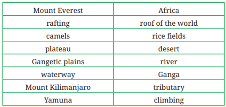
Ans: 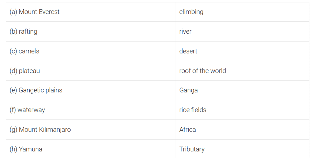
Q33: What is grassroots democracy? How does it empower people? (5 Marks)
Ans:
- Grassroots democracy is when people at the local level, like villages or towns, run their own government through bodies like Panchayats or ward committees.
- It lets them elect leaders, set rules, and solve problems like fixing wells or parks without waiting for far-off officials.
- For example, a Gram Sabha meeting lets villagers discuss a new school.
- It’s built from the ground up, starting with ordinary people’s voices.
- It empowers people by giving them power to shape their future—choosing a Sarpanch or a road to build—and teaches them to work together as a team.
- In a village, voting for a leader makes everyone feel they control their lives, not just big city rulers.
- This closeness makes democracy real, not distant, building confidence and responsibility in communities across India.
Q34: P and Q are urban bodies. P covers a whole city, Q is a smaller city unit.
(i) Name P.
(ii) What does P do?
(iii) Name Q.
(iv) Give one task of Q.
(v) How do P and Q make cities better? (5 Marks)
Ans:
(i) P is the Municipal Corporation, the body managing an entire city like Delhi or Chennai with elected leaders.
(ii) P handles big jobs like ensuring water supply, fixing roads, and removing garbage, keeping the city running smoothly for all its people every day.
(iii) Q is a Ward Committee, a smaller unit within the city led by a councillor, focusing on local areas.
(iv) One task of Q is fixing streetlights, ensuring safe, lit nights in its ward, like in a busy Kolkata neighborhood.
(v) P and Q make cities better by organizing wide services like clean water through P, and tackling small issues like park upkeep through Q. Together, they ensure no corner is ignored—P plans for the whole city, while Q zooms into streets and homes. For example, P might build a water tank, and Q repairs a drain nearby, improving life step by step for everyone.
The document Class 6 Social Science : Sample Paper Solutions - 3 | Sample Papers For Class 6 is a part of the Class 6 Course Sample Papers For Class 6.
All you need of Class 6 at this link: Class 6


FAQs on Class 6 Social Science : Sample Paper Solutions - 3 - Sample Papers For Class 6
| 1. What topics are typically covered in Class 6 Social Science? |  |
| 2. How can I prepare effectively for the Class 6 Social Science exam? | |
Ans. To prepare effectively, students should review their textbook chapters, make notes of key points, and practice past exam papers. Group study can also be beneficial, as discussing concepts with peers helps reinforce learning. Additionally, understanding maps and timelines is crucial for geography and history sections.
| 3. What type of questions can I expect in the Class 6 Social Science exam? | |
Ans. The exam may include multiple-choice questions, short answer questions, and long answer questions. Students can expect questions that require them to explain concepts, provide definitions, and compare different historical events or geographical features.
| 4. Are there any specific study materials recommended for Class 6 Social Science? | |
Ans. Recommended study materials include the prescribed textbook, supplementary reference books, and online resources such as educational videos and quizzes. Students should also utilize maps and atlases for geography topics to enhance their understanding.
| 5. How important is map work in the Class 6 Social Science curriculum? | |
Ans. Map work is very important in the Class 6 Social Science curriculum as it helps students understand geographical concepts and the location of historical events. It develops spatial thinking and the ability to interpret information presented visually, which is essential for both exams and real-world applications.
Related Exams
About this Document

Mar 26, 2025
Last updated
Document Description: Class 6 Social Science : Sample Paper Solutions - 3 for Class 6 2025 is part of Sample Papers For Class 6 preparation.
The notes and questions for Class 6 Social Science : Sample Paper Solutions - 3 have been prepared according to the Class 6 exam syllabus. Information about Class 6 Social Science : Sample Paper Solutions - 3 covers topics
like and Class 6 Social Science : Sample Paper Solutions - 3 Example, for Class 6 2025 Exam. Find important definitions, questions, notes, meanings, examples, exercises and tests below for Class 6 Social Science : Sample Paper Solutions - 3.
Introduction of Class 6 Social Science : Sample Paper Solutions - 3 in English is available as part of our Sample Papers For Class 6
for Class 6 & Class 6 Social Science : Sample Paper Solutions - 3 in Hindi for Sample Papers For Class 6 course.
Download more important topics related with notes, lectures and mock test series for Class 6
Exam by signing up for free. Class 6: Class 6 Social Science : Sample Paper Solutions - 3 | Sample Papers For Class 6
Description
Full syllabus notes, lecture & questions for Class 6 Social Science : Sample Paper Solutions - 3 | Sample Papers For Class 6 - Class 6 | Plus excerises question with solution to help you revise complete syllabus for Sample Papers For Class 6 | Best notes, free PDF download
Information about Class 6 Social Science : Sample Paper Solutions - 3
In this doc you can find the meaning of Class 6 Social Science : Sample Paper Solutions - 3 defined & explained in the simplest way possible. Besides explaining types of
Class 6 Social Science : Sample Paper Solutions - 3 theory, EduRev gives you an ample number of questions to practice Class 6 Social Science : Sample Paper Solutions - 3 tests, examples and also practice Class 6
tests

Related Searches
Sample Paper
,Class 6 Social Science : Sample Paper Solutions - 3 | Sample Papers For Class 6
,practice quizzes
,Class 6 Social Science : Sample Paper Solutions - 3 | Sample Papers For Class 6
,Summary
,Semester Notes
,Exam
,mock tests for examination
,Objective type Questions
,MCQs
,shortcuts and tricks
,video lectures
,Free
,Extra Questions
,ppt
,past year papers
,study material
,Viva Questions
,Class 6 Social Science : Sample Paper Solutions - 3 | Sample Papers For Class 6
,Important questions
,Previous Year Questions with Solutions
;


Additional Information about Class 6 Social Science : Sample Paper Solutions - 3 for Class 6 Preparation
Class 6 Social Science : Sample Paper Solutions - 3 Free PDF Download
The Class 6 Social Science : Sample Paper Solutions - 3 is an invaluable resource that delves deep into the core of the Class 6 exam.
These study notes are curated by experts and cover all the essential topics and concepts, making your preparation more efficient and effective.
With the help of these notes, you can grasp complex subjects quickly, revise important points easily,
and reinforce your understanding of key concepts. The study notes are presented in a concise and easy-to-understand manner,
allowing you to optimize your learning process. Whether you're looking for best-recommended books, sample papers, study material,
or toppers' notes, this PDF has got you covered. Download the Class 6 Social Science : Sample Paper Solutions - 3 now and kickstart your journey towards success in the Class 6 exam.
Importance of Class 6 Social Science : Sample Paper Solutions - 3
The importance of Class 6 Social Science : Sample Paper Solutions - 3 cannot be overstated, especially for Class 6 aspirants.
This document holds the key to success in the Class 6 exam.
It offers a detailed understanding of the concept, providing invaluable insights into the topic.
By knowing the concepts well in advance, students can plan their preparation effectively.
Utilize this indispensable guide for a well-rounded preparation and achieve your desired results.
Class 6 Social Science : Sample Paper Solutions - 3 Notes
Class 6 Social Science : Sample Paper Solutions - 3 Notes offer in-depth insights into the specific topic to help you master it with ease.
This comprehensive document covers all aspects related to Class 6 Social Science : Sample Paper Solutions - 3.
It includes detailed information about the exam syllabus, recommended books, and study materials for a well-rounded preparation.
Practice papers and question papers enable you to assess your progress effectively.
Additionally, the paper analysis provides valuable tips for tackling the exam strategically.
Access to Toppers' notes gives you an edge in understanding complex concepts.
Whether you're a beginner or aiming for advanced proficiency, Class 6 Social Science : Sample Paper Solutions - 3 Notes on EduRev are your ultimate resource for success.
Class 6 Social Science : Sample Paper Solutions - 3 Class 6 Questions
The "Class 6 Social Science : Sample Paper Solutions - 3 Class 6 Questions" guide is a valuable resource for all aspiring students preparing for the
Class 6 exam. It focuses on providing a wide range of practice questions to help students gauge
their understanding of the exam topics. These questions cover the entire syllabus, ensuring comprehensive preparation.
The guide includes previous years' question papers for students to familiarize themselves with the exam's format and difficulty level.
Additionally, it offers subject-specific question banks, allowing students to focus on weak areas and improve their performance.
Study Class 6 Social Science : Sample Paper Solutions - 3 on the App
Students of Class 6 can study Class 6 Social Science : Sample Paper Solutions - 3 alongwith tests & analysis from the EduRev app,
which will help them while preparing for their exam. Apart from the Class 6 Social Science : Sample Paper Solutions - 3,
students can also utilize the EduRev App for other study materials such as previous year question papers, syllabus, important questions, etc.
The EduRev App will make your learning easier as you can access it from anywhere you want.
The content of Class 6 Social Science : Sample Paper Solutions - 3 is prepared as per the latest Class 6 syllabus.
|
© EduRev
|
Education Revolution
|


|


Signup on EduRev and stay on top of your study goals
10M+ students crushing their study goals daily