UPSC Mains Answer PYQ 2024: Geology Paper 1 (Section- A) | Geology Optional for UPSC PDF Download

SECTION A
Q1: Answer the following questions in about 150 words each: (10 × 5 = 50 Marks)
(a) Discuss two widely accepted theories of origin of the earth. Elucidate the position of all planets within the solar system and write the important facts of the earth.
Ans: The origin of the Earth is a complex and fascinating subject, with numerous theories proposed by geologists and astronomers over the years. Among the various hypotheses, two of the most widely accepted ones are the Nebular Hypothesis and the Collision Theory. These theories aim to explain how the Earth, as well as the entire solar system, came into existence.
Theories of Origin of the Earth
Nebular Hypothesis (Kant-Laplace Hypothesis):
Proposed by Immanuel Kant and Pierre-Simon Laplace in the 18th century.
This theory suggests that the solar system, including Earth, formed from a giant rotating cloud of gas and dust called a nebula.
As the nebula cooled, it contracted under gravity, and the central mass formed the Sun while the surrounding material clumped together to form the planets.
This theory explains the alignment of planets in the same plane and their near-circular orbits.
Collision Theory (Catastrophic Hypothesis):
Proposed by George Darwin and others in the 19th century.
This theory suggests that the Earth was formed through the collision of two planetary bodies, one of which was Earth and the other a Mars-sized body.
The collision caused debris to form a ring around Earth, which eventually coalesced into the Moon.
This theory explains the Moon's composition and its relatively small size compared to Earth.
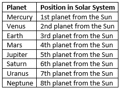
Position of Planets in the Solar System
The solar system consists of the Sun and eight planets that orbit it in elliptical orbits. The planets, listed in order of their distance from the Sun, are as follows:
Important Facts about Earth
- Age: The Earth is approximately 4.54 billion years old.
- Size: Earth has a diameter of about 12,742 kilometers.
- Atmosphere: The Earth's atmosphere is composed of 78% nitrogen, 21% oxygen, and trace amounts of other gases.
- Surface: Earth has a surface covered by 71% water and 29% land.
- Life: Earth is the only known planet to support life due to its suitable conditions, including a breathable atmosphere and liquid water.
The theories of the origin of Earth, whether through gradual processes as described by the Nebular Hypothesis or through a catastrophic event as in the Collision Theory, provide a framework for understanding the formation of the planet. The Earth's unique position in the solar system, with its conducive environment for life, further highlights its significance.
(b) What are the planar and linear structures of a rock? Discuss the genesis of boudins.
Ans: In geology, rocks exhibit a variety of structures that form due to the forces acting upon them. Among these, planar and linear structures are significant in understanding the geological history and deformation processes. Boudins, another important feature, arise from the deformation of rocks under certain conditions.
Planar and Linear Structures of a Rock
Planar Structures:
Planar structures are flat surfaces or layers that develop in rocks due to tectonic forces or sedimentary processes.
Examples of planar structures include:
Bedding Planes: Horizontal layers of sedimentary rock formed due to the deposition of materials over time.
Foliation: The parallel alignment of minerals in metamorphic rocks caused by directional pressure.
Joints: Fractures in rocks that occur without displacement, forming flat surfaces.
Linear Structures:
Linear structures are features that extend along a line, often formed by the movement of rocks or the alignment of minerals under stress.
Examples of linear structures include:
Folds: Curved layers of rock formed due to compressive forces, such as anticlines (upward folds) and synclines (downward folds).
Faults: Fractures in the Earth's crust where displacement has occurred along a linear axis.
Linear Features in Metamorphic Rocks: Alignment of minerals like mica or amphibole.
Genesis of Boudins
Definition: Boudins are elongated, lens-shaped fragments of rock that are separated by faults or fractures in ductile rocks during deformation.
Formation Process:
Boudins form in layers of rock subjected to intense compressive forces, which cause the rock to stretch and break.
The rock experiences differential stress, leading to the stretching of weaker layers and the formation of narrow necks between more resistant rock.
These necks break, and the fragments that remain are boudins, often surrounded by a matrix of other rock.
Example: In the Swiss Alps, boudins have been observed in metamorphic rocks like schists, where the deformation is caused by tectonic compression.
Both planar and linear structures reveal much about the stresses and processes that have shaped the Earth's crust. Boudins, in particular, provide a clear example of how rocks deform under strain, offering valuable insight into the Earth's geological history.
(c) Discuss the applications of remote sensing in Geology.
Ans: Remote sensing refers to the collection of information about the Earth's surface without direct contact, usually through satellites or aerial sensors. In geology, remote sensing provides a powerful tool for mapping, analyzing, and monitoring geological features, offering insights into areas that may be inaccessible or too dangerous for direct observation.
Applications of Remote Sensing in Geology
Mapping Geological Features:
Remote sensing allows for the creation of detailed maps of geological features, such as rock formations, fault lines, and mineral deposits.
Satellite imagery and aerial photography help geologists identify and map large-scale features such as mountains, rivers, and volcanic areas.
Mineral Exploration:
Remote sensing is widely used in mineral exploration by detecting surface anomalies that may indicate the presence of valuable minerals.
Spectral analysis, particularly through hyperspectral remote sensing, helps identify specific minerals based on their spectral signatures.
Monitoring of Geological Hazards:
Remote sensing plays a crucial role in monitoring natural hazards like landslides, earthquakes, and volcanic eruptions.
Satellite-based radar interferometry (InSAR) can detect ground movements associated with seismic activity, providing early warnings for potential earthquakes or landslides.
Land Use and Environmental Studies:
Remote sensing allows for the monitoring of changes in land use and environmental conditions, such as deforestation, urbanization, and coastal erosion.
This information is vital for managing natural resources and mitigating environmental disasters.
Climate Change Research:
Remote sensing is used to study changes in glaciers, sea levels, and other geological indicators of climate change.
Satellite data helps track the shrinking of ice sheets or shifts in ocean currents, providing valuable data for climate models.
The applications of remote sensing in geology are vast and varied, enabling geologists to explore and monitor the Earth's surface in ways that were previously impossible. By using remote sensing technologies, we can gain valuable insights into the Earth's dynamic processes, providing essential data for scientific research, natural resource management, and disaster preparedness.
(d) Discuss the process of soil formation.
Ans: Soil is a vital component of the Earth's surface, formed through complex physical, chemical, and biological processes. It serves as the foundation for agriculture, plant growth, and various geological and ecological functions. The formation of soil is a continuous and dynamic process that results from the weathering of rocks and the decomposition of organic matter over time. This process is called pedogenesis.
Process of Soil Formation (Pedogenesis)
The formation of soil involves the transformation of parent rock material into a fertile medium. It includes the following stages:
Weathering of Parent Rock (Regolith Formation):
Weathering is the breakdown of rocks into smaller particles through mechanical, chemical, and biological processes.
Mechanical weathering: Caused by temperature changes, frost action, and physical abrasion.
Chemical weathering: Involves reactions like hydrolysis, oxidation, carbonation, and hydration (e.g., feldspar converting to clay).
Biological weathering: Carried out by plant roots, lichens, and microorganisms that secrete acids.
Addition of Organic Material:
Plants and animals contribute organic matter through decayed leaves, dead organisms, and waste.
Decomposition by microbes forms humus, a rich organic component essential for soil fertility.
Leaching and Illuviation:
Leaching: The process by which water percolates through the soil, dissolving minerals and carrying them downward.
Illuviation: The deposition of these dissolved substances in lower soil horizons, forming distinct layers (e.g., iron and clay accumulation in B horizon).
Soil Horizon Development:
Over time, distinct layers or horizons form:
O Horizon: Organic matter
A Horizon: Topsoil rich in humus
B Horizon: Subsoil with leached materials
C Horizon: Weathered parent rock
R Horizon: Unweathered bedrock
Influencing Factors (Jenny’s Equation):
Soil formation is influenced by several factors, formulated by Hans Jenny (1941):
S = f(cl, o, r, p, t)
Where:
- S = Soil
- cl = Climate
- o = Organisms
- r = Relief (topography)
- p = Parent material
- t = Time
Examples
- In tropical climates, intense rainfall accelerates chemical weathering and leaching, forming lateritic soils.
- In arid regions, limited rainfall leads to calcareous soils due to salt accumulation.
- Volcanic ash in regions like Java or Hawaii leads to fertile andisols.
Soil formation is a continuous process driven by a combination of geological, climatic, biological, and temporal factors. Understanding this process is crucial for land use planning, agriculture, and environmental conservation. The theory by Hans Jenny provides a scientific basis for understanding the variables that control soil development across different regions.
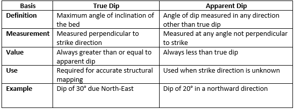
(e) Define dip of a rock bed. What is true dip and apparent dip? Find the strike direction of a bed which dips 30° towards North 30° East.
Ans: In structural geology, understanding the orientation of rock layers is essential. Two primary measurements used are dip and strike. These help geologists determine the inclination and direction of rock beds, faults, or other planar geological features.
Dip of a Rock Bed
Dip is the angle at which a rock bed or planar surface inclines relative to the horizontal plane.
It has two components:
- Angle of dip: The magnitude of inclination (in degrees).
- Direction of dip: The compass direction in which the bed is inclined downward.
Types of Dip
Geological Theory Reference
The concept of dip and strike was formalized by early structural geologists such as James Hutton, the father of modern geology, who emphasized understanding rock orientations to decipher Earth's geological history.
Finding Strike Direction
Given: Dip is 30° towards N30°E
Strike is always perpendicular to dip direction.
- Dip Direction: N30°E
- Strike Direction: Add or subtract 90° to dip direction.
Strike = N30° E ± 90°
Thus, the strike directions are:
- N60°W – S60°E
This means the horizontal line on the bedding plane runs NW to SE, perpendicular to the dipping direction.
Understanding the dip and strike of a rock bed is fundamental for geological mapping, mining, and civil engineering. The distinction between true and apparent dip is crucial for accurate interpretation of subsurface structures. By using simple trigonometric principles and compass directions, geologists can determine the orientation of rock strata with precision.
Q2:
(a) Discuss the intensity and magnitude scale commonly used to assess seismic damage. Write a note on the global distribution pattern of earthquake. Mark the different seismic zones of India on the given map and discuss about them. (20 Marks)
Ans: Earthquakes are sudden ground movements caused by the release of energy stored in rocks due to tectonic stresses. To understand and compare the severity of earthquakes, scientists use two main types of scales: magnitude and intensity. These scales, along with the study of seismic zones and global distribution patterns, help in hazard assessment and mitigation.
1. Magnitude and Intensity Scales

- Richter Scale (1935): Developed by Charles Richter, it is effective for measuring small to moderate earthquakes.
- Moment Magnitude Scale (Mw): More accurate for large events and currently preferred.
2. Global Distribution Pattern of Earthquakes:
Earthquakes mainly occur along plate boundaries:
- Circum-Pacific Belt (Ring of Fire) – Most seismically active (Japan, Chile).
- Mid-Atlantic Ridge – Spreading zones (Iceland).
- Himalayan Belt – Continental collision zone (India, Nepal).
- East African Rift – Intraplate activity.
Example: 2011 Japan Earthquake (Mw 9.0) – Pacific Plate subduction.
3. Seismic Zones of India:
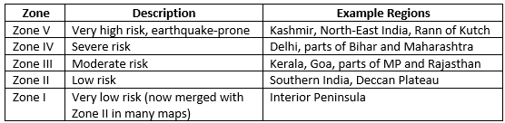
Seismic Zonation Map of India (BIS Code IS: 1893) classifies the country into zones based on historical data and plate tectonics.
Understanding the scales of earthquake measurement and the seismic zones is vital for earthquake-resistant construction, disaster preparedness, and land use planning. With India’s location at the convergent boundary of the Indian and Eurasian plates, continuous monitoring and updated zonation are crucial.
(b) Discuss in detail the ideas of geomorphic cycle proposed by Davis and Penck. (15 Marks)
Ans: The concept of the geomorphic cycle attempts to explain the evolution of landforms over time due to erosion and other geomorphic processes. Two key contributors to this field are William Morris Davis and Walther Penck, whose theories laid foundational ideas in geomorphology. While Davis proposed a sequential model, Penck emphasized the influence of uplift and erosion acting simultaneously.
1. Davis’s Geomorphic Cycle (Cycle of Erosion):
Proposed by William Morris Davis in the late 19th century, the Cycle of Erosion explains landscape development in three stages under humid climatic conditions.
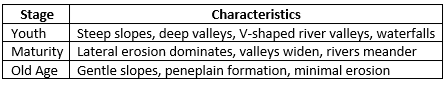
- Theory Basis: Landscape evolves under initial uplift, followed by erosion over time.
- Diagram: Sequence from uplift to peneplain.
- Criticism: Oversimplified; assumes uniform climate and ignores tectonic interruptions.
Example: Appalachian Mountains show stages of maturity and old age.
2. Penck’s Model of Landscape Evolution:
German geomorphologist Walther Penck presented an alternative view in the early 20th century, emphasizing the rate of uplift relative to erosion.
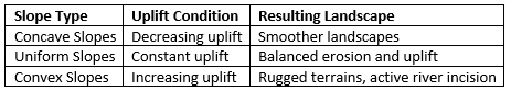
- Theory Basis: Erosion and uplift occur simultaneously, not sequentially.
- Backwearing and Downwearing: Hillslopes recede backward (backwearing) while elevation decreases (downwearing).
- Diagram: Slopes shaped under different uplift conditions.
Example: The Black Forest region in Germany reflects Penck’s ideas of uniform slope retreat.
3. Comparison: Davis vs. Penck
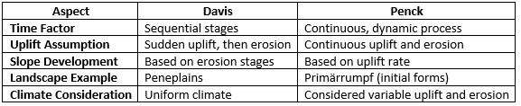
Both Davis and Penck contributed significantly to the understanding of landscape evolution. Davis’s model is more descriptive and easier to visualize, whereas Penck’s theory integrates tectonic dynamics, making it more applicable in active regions. Today, geomorphologists often take a hybrid approach, combining both perspectives depending on regional geology and tectonic activity.
(c) What do contours represent in a toposheet? How do the contour lines help to identify the different geomorphic features of an area? Explain with neat diagrams. (15 Marks)
Ans: Contours in a topographic map represent lines connecting points of equal elevation. These lines help to visualize the shape and elevation of the land surface.
What do contours represent in a toposheet?
Contours are fundamental elements of a toposheet, representing the three-dimensional landscape in two dimensions through lines that indicate elevation.
- Definition of Contours:
- Contour lines are imaginary lines on a map that join points of the same elevation above a reference point, usually sea level.
- Purpose:
- They depict the topography of an area, including elevation, slope, and relief.
- Serve as a guide to understanding the terrain's shape and features.
- Rules of Contour Representation:
- Contour lines never cross, as a point cannot have two different elevations.
- Closely spaced contours indicate steep slopes, while widely spaced ones indicate gentle slopes.
- Closed contours often represent hills (elevation increasing inward) or depressions (elevation decreasing inward).
How do contour lines help identify different geomorphic features?
Contour lines are essential for interpreting the shape and nature of landforms. By analyzing the patterns and spacing of contours, various geomorphic features can be identified:
a. Hills and Mountains
- Closed, circular, or oval contour lines with increasing elevation toward the center.
- Tightly packed contours indicate steep slopes of a mountain.
b. Valleys and Rivers
- V-shaped contours pointing uphill indicate valleys.
- The sharp end of the "V" usually points toward higher elevation, showing the flow direction of water.
c. Ridges
- U-shaped contours pointing downhill represent ridges.
- These typically indicate areas of higher ground extending laterally.
d. Plateaus
- Contours that form a closed loop with a significant flat area within indicate a plateau.
- The elevation remains relatively consistent across the central region.
e. Depressions or Basins
- Closed contour lines with decreasing elevation toward the center.
- Hachure marks inside the contour indicate a depression.
f. Cliffs
- Very tightly spaced or overlapping contours suggest vertical or near-vertical terrain.
g. Saddle
- Low points between two higher elevation areas, shown by two opposing "U" or "V" shapes.
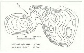
Contour lines in a topographic map are essential for understanding the elevation and geomorphology of an area. By interpreting these lines, one can identify various landforms and navigate through the terrain effectively.
Q3:
(a) Discuss in detail, with diagrams, the landforms and features resulting from deposition by rivers. (20 Marks)
Ans: Deposition is the process by which sediment carried by a river is dropped or deposited on the riverbed or its banks. This process leads to the formation of various landforms and features along the course of the river.
Landforms Resulting from Deposition by Rivers:
1. Floodplains
- Flat areas adjacent to a river, formed by the deposition of sediments during flooding.
- Formation Process:
- During floods, rivers overflow their banks and deposit fine sediments like silt and clay.
- Repeated flooding creates a fertile layer of alluvium.
- Features: Fertile soils suitable for agriculture.
2. Levees
- Raised embankments formed along riverbanks.
- Formation Process:
- Coarser sediments are deposited close to the river channel during flooding, creating natural barriers.
- Features: Protect adjacent lands from minor flooding.
3. Deltas
- Triangular landforms where rivers meet a larger water body like an ocean or a lake.
- Formation Process:
- Rivers lose energy upon entering a larger body, causing sediment deposition.
- Divided into arcuate (fan-shaped), bird-foot, and cuspate deltas depending on sediment type and wave activity.
- Examples: Nile Delta, Ganges-Brahmaputra Delta.
4. Alluvial Fans
- Fan-shaped deposits at the base of a mountain where a river exits a steep valley.
- Formation Process:
- Sediment spreads out as the river slows down and loses energy on flatter terrain.
- Features: Coarser material is deposited closer to the mountain, with finer sediments spread further away.
5. Meanders and Oxbow Lakes
- Sinuous bends in a river, with oxbow lakes formed from abandoned meanders.
- Formation Process:
- Deposition occurs on the inside of a meander bend where the river flow is slower.
- Over time, meanders become more pronounced and may get cut off to form oxbow lakes.
- Examples: Found in lowland rivers like the Mississippi.
6. Point Bars
- Crescent-shaped deposits on the inner side of meanders.
- Formation Process:
- Slower water flow on the inner side leads to deposition of sand and gravel.
- Features: Vegetation may stabilize the deposits.
7. Natural Polders
- Enclosed floodplains formed between river levees and the surrounding areas.
- Formation Process:
- Fine silt and clay are deposited in these low-lying areas during floods.
- Features: Often waterlogged or reclaimed for agriculture.
Diagrammatic Representation:
 Deposition by rivers leads to the formation of a variety of landforms and features that play a crucial role in shaping the landscape and supporting ecosystems. Understanding these landforms is essential for managing river systems and protecting the environment.
(b) Describe the characteristics of Indian remote sensing satellites. (15 Marks)
Ans: Indian remote sensing satellites are known for their advanced technology and capabilities.
Characteristics of Indian Remote Sensing Satellites (IRS)
1. Evolution and Development
- Initiation: The IRS program began in the 1980s to support India's developmental goals.
- First Satellite: IRS-1A, launched in 1988, marked the beginning of India's operational remote sensing program.
- Continuous Advancement: From early satellites like IRS-1A to advanced satellites like CartoSat and ResourceSat, the IRS series has grown in capability.
2. Types of Satellites
- ResourceSat Series: Focuses on natural resource management, with applications in agriculture, forestry, and land-use mapping.
- CartoSat Series: Provides high-resolution imagery for cartography and urban and rural planning.
- OceanSat Series: Supports oceanographic studies such as monitoring ocean color and wind speed.
- RISAT Series: Uses synthetic aperture radar for all-weather surveillance, aiding agriculture and disaster management.
- HySIS: Focuses on hyperspectral imaging for detailed analysis of Earth's surface.
3. Orbit and Coverage
- Sun-Synchronous Orbits: Ensures consistent lighting conditions, crucial for capturing accurate and repeatable images.
- Global Reach: The satellites cover all regions, enabling comprehensive mapping and monitoring.
4. Sensor Capabilities
- Multispectral and Hyperspectral Sensors: Capture data across various wavelengths for detailed analysis.
- High Spatial Resolution: Enables detailed mapping and identification of small features.
- Temporal Resolution: Provides frequent revisits for monitoring dynamic changes.
5. Payload and Technology
- Advanced Imaging Systems: Includes panchromatic cameras, multispectral sensors, and synthetic aperture radar (SAR).
- Multiple Spectral Bands: Supports applications ranging from agriculture to mineral exploration.
- Data Transmission: Uses advanced communication systems for rapid data transfer to ground stations.
6. Applications
- Geology: Mineral exploration, mapping geological structures, and monitoring geological hazards.
- Agriculture: Crop health assessment, soil moisture analysis, and precision farming.
- Forestry: Monitoring deforestation, biodiversity assessment, and forest health evaluation.
- Disaster Management: Early warning and impact assessment for floods, earthquakes, and cyclones.
7. Contribution to National Development
- Support for Governance: Aids in policy-making through accurate land-use and resource data.
- Economic Benefits: Enhances agricultural productivity, mineral exploration, and infrastructure development.
- Environmental Conservation: Assists in monitoring and managing natural resources sustainably.
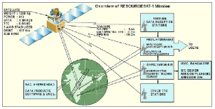
Indian remote sensing satellites are known for their advanced technology, imaging capabilities, and wide range of applications. They play a crucial role in monitoring and managing various aspects of the Earth's surface, making them an important tool for scientific research and decision-making.
(c) Diagrammatically explain the formation of normal fault, strike-slip fault and thrust fault with the help of stress ellipsoid. (15 Marks)
Ans: Faults are fractures in the Earth's crust where movement has occurred. There are three main types of faults: normal faults, strike-slip faults, and thrust faults. These faults are formed due to different types of stress acting on the rocks in the Earth's crust.
Formation of Faults: Normal Fault, Strike-Slip Fault, and Thrust Fault with Stress Ellipsoid
The formation of different types of faults can be explained using stress ellipsoids. These diagrams represent the principal stresses (σ1, σ2, σ3) acting on a rock body, where:
- σ1: Maximum principal stress.
- σ2: Intermediate principal stress.
- σ3: Minimum principal stress.
1. Normal Fault
- Formation: Occurs under tensional stress where rocks are pulled apart.
- Stress Ellipsoid:
- σ1 is vertical, causing the crust to stretch.
- σ3 (minimum stress) acts horizontally, perpendicular to the fault plane.
- Diagram Explanation:
- Hanging wall moves downward relative to the footwall.
- Fault plane dips steeply, typically between 50° and 70°.
2. Strike-Slip Fault
- Formation: Results from horizontal shear stress where two blocks move laterally past each other.
- Stress Ellipsoid:
- σ1 and σ3 are horizontal.
- σ2 is vertical, allowing for lateral movement.
- Diagram Explanation:
- No vertical displacement, movement is horizontal.
- Commonly categorized as:
- Right-lateral (dextral): Block on the opposite side moves to the right.
- Left-lateral (sinistral): Block on the opposite side moves to the left.
3. Thrust Fault
- Formation: Forms under compressional stress when the crust is pushed together.
- Stress Ellipsoid:
- σ1 is horizontal, indicating strong compressive forces.
- σ3 is vertical, leading to shortening and thickening of the crust.
- Diagram Explanation:
- Hanging wall moves upward relative to the footwall.
- Fault plane dips shallowly, typically less than 30°.
General Characteristics:
- Stress Orientation:
- Normal fault: Tension dominates; σ3 horizontal.
- Strike-slip fault: Shear dominates; σ2 vertical.
- Thrust fault: Compression dominates; σ3 vertical.
- Geological Context:
- Normal faults: Extensional regimes like rift zones.
- Strike-slip faults: Transform plate boundaries (e.g., San Andreas Fault).
- Thrust faults: Convergent boundaries and orogenic belts.
Diagrams

Normal faults are formed by tensional stress, strike-slip faults are formed by shear stress, and thrust faults are formed by compressional stress. The stress ellipsoid can help us understand how these different types of faults are formed and how the rocks move along the fault planes.
Q4:
(a) Describe fold geometry. Illustrate various types of folds on the basis of their symmetry, orientation of axial plane and the trend of the fold axis. (20 Marks)
Ans: Folding is a structural deformation of rocks that occurs due to compressive forces, especially in sedimentary strata. Understanding fold geometry helps in geological mapping, mineral exploration, and interpreting tectonic processes.
1. Fold Geometry: Key Terms
- Fold Axis: The line that runs along the crest or trough of the fold.
- Axial Plane: An imaginary surface that divides the fold symmetrically.
- Limbs: The sides of a fold.
- Hinge: The point of maximum curvature.
- Plunge: Angle the fold axis makes with the horizontal.
2. Classification of Folds
A. Based on Symmetry (Axial Plane Geometry)

B. Based on Fold Axis Orientation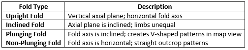
3. Examples in Nature:
- Zagros Mountains (Iran) – Broad symmetrical folds.
- Himalayas – Recumbent and overturned folds due to intense compressive forces.
- Appalachians (USA) – Plunging folds visible in valley-ridge topography.
4. Geologist Theory:
John Ramsay: In structural geology, Ramsay’s work on fold mechanics and strain analysis laid the foundation for understanding fold geometry in deformed terrains.
Fold geometry offers critical insights into the tectonic history and stress regimes that shaped a region. From symmetrical to plunging, folds are classified based on observable geometry, enabling geologists to decode deformation patterns, mineral traps, and subsurface structures efficiently.
(b) Describe and illustrate different types of plate boundaries, and explain the mechanism of plate motion. (15 Marks)
Ans: The theory of Plate Tectonics explains the movement of lithospheric plates over the asthenosphere. The boundaries where plates interact are zones of major geological activity such as earthquakes, volcanism, and mountain building.
1. Types of Plate Boundaries
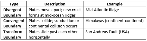
Diagram Description:
- Divergent: Arrows pointing away, ridge in the center.
- Convergent: Arrows colliding, with one plate subducting.
- Transform: Arrows sliding laterally past each other.
2. Mechanisms of Plate Motion
A. Mantle Convection:
- Heat from Earth’s core causes convection currents in the mantle.
- These currents drag plates along the surface.
B. Ridge Push: Elevated mid-ocean ridges push plates apart due to gravitational force.
C. Slab Pull: Cold, dense subducting plates pull the trailing plate downward.
3. Geologist Perspective:
- Dan McKenzie and Jason Morgan (1960s): Proposed plate tectonics based on mantle convection and lithospheric motion.
- Tuzo Wilson: Introduced the idea of transform faults and Wilson Cycle of plate evolution.
Plate boundaries are zones of immense geological activity, shaping Earth’s surface through interactions like subduction and rifting. The dynamic movement of plates, driven by mantle forces, continues to reshape continents, oceans, and mountain belts.
(c) "At depth of compensation, the pressure generated by all overlying landmass substances on the earth is everywhere equal." Describe the hypotheses which support this statement. (15 Marks)
Ans: The Depth of Compensation refers to a theoretical level within the Earth’s crust where the pressure exerted by overlying materials is equalized everywhere. This concept is central to isostasy, explaining how Earth's crust maintains gravitational balance.
1. The Statement Explained:
- At the depth of compensation, any variation in surface elevation (like mountains or ocean basins) is balanced by subsurface density adjustments.
- It's the point where the weight of overlying rock columns is uniform across the globe, regardless of topography.
2. Hypotheses Supporting the Statement:
A. Airy's Hypothesis (1855) – Proposed by George Biddell Airy
- Crust has variable thickness.
- Mountains have thicker roots of lighter crustal material to balance the weight.
- Like icebergs floating on water.
Example: The Himalayas have deep crustal roots.
Diagram Description: Cross-section showing tall mountains with deeper roots.
B. Pratt’s Hypothesis (1855) – By John Henry Pratt
- Crust has uniform thickness, but density varies.
- Higher areas are made of less dense material, lower regions are denser.
Example: Explains ocean basins and plateaus.
Diagram Description: Columns of equal thickness but varying density.
C. Heiskanen’s Hypothesis (1931):
- Combines both density variation and crustal thickness.
- Used for regional isostatic compensation (e.g., Greenland).
D. Vening Meinesz Flexural Isostasy (1931):
- Crust behaves like an elastic plate that bends under load.
- Explains compensation in long mountain belts and ocean trenches.
Example: Andes mountain loading over the lithosphere.
3. Modern Isostatic Concepts:
- Supported by seismic studies and gravity anomalies.
- Widely used in crustal thickness mapping, tectonic studies, and glacier rebound analysis.
The concept of the depth of compensation is fundamental in understanding crustal equilibrium. Various hypotheses like those of Airy, Pratt, and Meinesz offer different yet complementary perspectives. These models remain crucial in geophysical and tectonic interpretations today.
|
64 videos|135 docs
|
FAQs on UPSC Mains Answer PYQ 2024: Geology Paper 1 (Section- A) - Geology Optional for UPSC
| 1. What are the key topics covered in the Geology Paper 1 of the UPSC Mains exam? |  |
| 2. How can candidates effectively prepare for the Geology Paper 1 in the UPSC Mains exam? | |
| 3. What is the significance of understanding mineralogy for the UPSC Geology Paper 1? | |
| 4. Are there any specific reference books recommended for studying Geology for the UPSC Mains? | |
| 5. What types of questions can candidates expect in the Geology Paper 1 exam? | |


Free
,past year papers
,Summary
,mock tests for examination
,Exam
,Semester Notes
,UPSC Mains Answer PYQ 2024: Geology Paper 1 (Section- A) | Geology Optional for UPSC
,Objective type Questions
,UPSC Mains Answer PYQ 2024: Geology Paper 1 (Section- A) | Geology Optional for UPSC
,study material
,Previous Year Questions with Solutions
,practice quizzes
,MCQs
,UPSC Mains Answer PYQ 2024: Geology Paper 1 (Section- A) | Geology Optional for UPSC
,Viva Questions
,Important questions
,Sample Paper
,ppt
,shortcuts and tricks
,Extra Questions
,video lectures
;


UPSC Mains Answer PYQ 2024: Geology Paper 1 (Section- A) Free PDF Download
Importance of UPSC Mains Answer PYQ 2024: Geology Paper 1 (Section- A)
UPSC Mains Answer PYQ 2024: Geology Paper 1 (Section- A) Notes
UPSC Mains Answer PYQ 2024: Geology Paper 1 (Section- A) UPSC Questions
Study UPSC Mains Answer PYQ 2024: Geology Paper 1 (Section- A) on the App
|
© EduRev
|
Education Revolution
|


|


within 7 days!