UPSC Mains Answer PYQ 2024: Geology Paper 1 (Section- B) | Geology Optional for UPSC PDF Download

SECTION B
Q5: Answer the following questions in about 150 words each: (10 × 5 = 50 Marks)
(a) Define species and explain how paleontological species are different from biological species.
Ans: Species are fundamental units of biological classification and biodiversity. Their concept helps in understanding evolution, ecology, and paleontology. However, definitions vary based on context—especially when dealing with fossils versus living organisms.
Definition of Species
- Biological Species (Mayr’s Concept): Ernst Mayr (1942) defined a species as "groups of actually or potentially interbreeding natural populations that are reproductively isolated from other such groups."
Paleontological Species: Species identified based on morphological differences in fossil records, where reproductive behavior cannot be studied.
Differences Between Paleontological and Biological Species
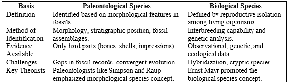
Thus, while biological species are defined based on reproductive isolation, paleontological species rely on observable morphology in fossils. Both concepts are essential, but they serve different scientific needs depending on the available evidence.
(b) Discuss the geological parameters used to subdivide the Dharwar Craton into two subcratons.
Ans: The Dharwar Craton, located in southern India, represents one of the oldest and most stable parts of the Indian Shield. Geologists have subdivided it into two distinct subcratons based on geological, structural, and geochronological differences.
Geological Parameters for Subdivision
Age and Crustal Evolution
Western Dharwar Craton (WDC): Older (3.3–3.0 Ga), composed of tonalite-trondhjemite-granodiorite (TTG) suites and greenstone belts.
Eastern Dharwar Craton (EDC): Slightly younger (3.0–2.5 Ga), characterized by extensive younger granitic intrusions.
Lithology
WDC: Dominated by volcanic greenstone belts (e.g., Sargur Group) and TTG gneisses.
EDC: Dominated by younger granitic rocks with minor greenstone belts (e.g., Kolar Schist Belt).
Structural Framework
WDC: Shows dome-and-basin structures typical of older terrains.
EDC: Features linear schist belts and extensive granitic plutons.
Tectonic History
WDC: Witnessed limited post-Archean tectonism.
EDC: Underwent significant reworking during the Neoarchean (2.7–2.5 Ga).
Isotopic Studies
Differences in Sm-Nd and Pb-Pb isotope data support the distinction.
Example: Kolar Gold Fields in EDC show younger, mineral-rich rocks compared to Dharwar greenstones in WDC.
Subdividing the Dharwar Craton helps geologists understand the evolution of continental crust in the Archean era. Distinct lithological, structural, and geochronological characteristics demarcate the Western and Eastern Dharwar Cratons.
(c) Describe the Cretaceous volcanic province in India.
Ans: The Cretaceous period (~145 to 66 million years ago) witnessed significant volcanic activity in India, resulting in large igneous provinces. These events have geological, ecological, and evolutionary significance.
Cretaceous Volcanic Provinces in India
Deccan Traps
Largest Cretaceous volcanic province in India, located mainly in Maharashtra, Madhya Pradesh, and Gujarat.
Consists of layered basaltic lava flows covering ~500,000 sq km.
Formed around 66 million years ago, coinciding with the Cretaceous-Paleogene (K-Pg) extinction.
Rajmahal Traps
Located in eastern India (Jharkhand and West Bengal).
Composed of basaltic flows and associated volcaniclastics.
Formed ~117 million years ago during the early Cretaceous.
Lameta Beds
Sedimentary intertrappean deposits lying between Deccan lava flows.
Important for dinosaur fossils (e.g., Rajasaurus, Titanosaurs).
Associated Geological Events
Tectonic rifting associated with the breakup of Gondwana.
Uplift and formation of Western Ghats.
Theories by Geologists
Courtillot and Renne (2003) proposed that Deccan volcanism significantly contributed to the mass extinction at the end of the Cretaceous.
Example: Lonar Crater: Though a meteorite impact site, the crater lies within Deccan basalts, providing insights into volcanic rock behavior.
The Cretaceous volcanic provinces of India, particularly the Deccan Traps, are crucial in understanding global geological events, mass extinctions, and the tectonic history of the Indian subcontinent.
(d) Describe how Darcy's law and Reynolds' number are related to the types of fluid flow in aquifers.
Ans: Understanding groundwater movement is essential for hydrogeology. Darcy’s Law and Reynolds’ Number are two key concepts that describe how fluids flow through porous media like aquifers, helping to distinguish between laminar and turbulent flows.
Darcy’s Law
- Proposed by: Henry Darcy (1856) through his experiments on water filtration through sand.
- Statement: The flow rate of water through a porous medium is proportional to the hydraulic gradient and the permeability of the medium.
- Mathematical Expression:
Q = -KA (dh/dl)
Where:
Q = Discharge (volume/time)
K = Hydraulic conductivity
A = Cross-sectional area
dh/dl = Hydraulic gradient (change in head per unit length)
Key Aspect: Assumes laminar flow — smooth, orderly movement of water.
Reynolds’ Number in Groundwater Flow
- Proposed by: Osborne Reynolds (1883) to distinguish flow types.
- Reynolds’ Number (Re):
Re = (ρvd)/μ
Where:
ρ = fluid density
v = velocity
d = characteristic length (pore diameter)
μ = dynamic viscosity
- Flow Type:
Laminar Flow: Re < 10 (in porous media like aquifers)
Turbulent Flow: Re > 10 (rare in groundwater unless in fractures/cavities)
Relation between Darcy’s Law and Reynolds’ Number
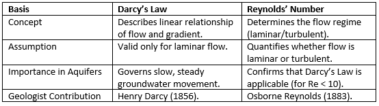 Example: In fine-grained sand aquifers, flow remains laminar (low Re), validating Darcy’s Law; however, in coarse gravel or fractured rock, flow can become turbulent.
Thus, Darcy’s Law and Reynolds’ Number together help determine how groundwater behaves in aquifers. Darcy’s Law applies when Reynolds’ Number indicates laminar flow. Understanding both concepts is critical for groundwater modeling and aquifer management.
(e) Describe the rehabilitation measures required in landslide-affected area to restore the community and the ecology of the area affected.
Ans: Landslides cause severe damage to lives, property, and ecosystems. Rehabilitation in landslide-affected areas requires a comprehensive approach that combines engineering, ecological restoration, and community support.
Rehabilitation Measures
Stabilization of Slopes
Construction of retaining walls, gabion structures, and rock bolts.
Re-grading steep slopes to reduce angles of repose.
Drainage Control
Installation of surface and subsurface drainage systems.
Diverting water away from vulnerable slopes to prevent saturation and further movement.
Reforestation and Bio-engineering
Planting deep-rooted vegetation like vetiver grass, bamboo, and pine to bind the soil.
Use of geotextiles and vegetated crib walls for eco-stabilization.
Theory: Schuster and Krizek (1978) emphasized bio-engineering techniques for slope stabilization.
Relocation and Housing
Shifting affected communities to safer areas.
Construction of landslide-resistant housing structures.
Early Warning Systems and Monitoring
Installation of inclinometers, piezometers, and GPS monitoring stations.
Community-based landslide early warning systems (CBLEWS).
Community Rehabilitation
Livelihood restoration programs (skill training, employment).
Psychological counseling for trauma-affected individuals.
Ecological Restoration
Restoration of native flora and fauna.
Reconstruction of natural drainage paths to prevent future instability.
Public Awareness and Training
Educating locals on landslide risks, evacuation protocols, and mitigation practices.
Examples
- Malin Landslide (Maharashtra, 2014): Post-disaster interventions included reforestation and building new village settlements at safer locations.
- Mizoram's community-based landslide warning system: A successful model integrating locals with scientific monitoring.
Rehabilitation in landslide-affected areas must address both physical stabilization and social rebuilding. Integrating engineering solutions with ecological methods and community engagement ensures sustainable recovery and resilience against future disasters.
Q6:
(a) Elucidate the evolutionary trend of Proboscidea with examples. (20 Marks)
Ans: The order Proboscidea includes large mammals such as elephants and their extinct relatives like mammoths and mastodons. Their evolution, marked by anatomical and ecological adaptations, showcases a remarkable evolutionary journey over 60 million years, reflecting environmental changes and migration patterns.
Evolutionary Trends of Proboscidea
Origin and Early Forms
Originated in Africa during the late Paleocene (~60 Ma).
Earliest known genus: Phosphatherium (small, pig-sized animal with semi-aquatic adaptations).
Adaptive Radiation
Moeritherium (Eocene, ~37 Ma): Semi-aquatic, short-legged, resembling a tapir; adapted to swampy environments.
Barytherium (late Eocene): Larger size, more developed tusks, adapted to terrestrial life.
Development of Tusks and Trunks
Proboscideans evolved elongated incisors (tusks) and an extended upper lip and nose forming a trunk.
Example: Palaeomastodon (early Oligocene) showed distinct tusks and rudimentary trunks.
Gomphotheres and Mastodons
Gomphotherium (Miocene): Developed four tusks (two upper and two lower).
Mammut (Mastodon, Miocene-Pleistocene): Adapted to forest habitats, with cuspate molars for browsing.
Modern Elephants
Elephas (Asian elephants) and Loxodonta (African elephants) appeared during the late Miocene (~5 Ma).
Evolved high-crowned molars suited for grazing.
Theories and Contributions
Osborn’s Proboscidean Theory (1918): Classified proboscidean evolution into four main trends — enlargement, dentition specialization, skull modifications, and trunk development.
Examples
Woolly Mammoth (Mammuthus primigenius): Adapted to Ice Age conditions.
Stegodon: Intermediate between mastodons and modern elephants.
The Proboscidea show an evolutionary trend from small, semi-aquatic forms to large, highly specialized land mammals. Adaptations in size, skull structure, and dentition reflect responses to changing climates and habitats.
(b) Describe lithostratigraphic classification and shift of depositional environments during deposition of the Vindhyan Supergroup. Comment on the age of the Vindhyan succession. (15 Marks)
Ans: The Vindhyan Supergroup is a major Proterozoic sedimentary sequence in India, offering crucial insights into Earth's early history. Its lithostratigraphy and depositional environments show systematic evolution over time.
Lithostratigraphic Classification of Vindhyan Supergroup
Lower Vindhyan
Consists of Semri Group (oldest).
Lithology: Sandstone, shale, limestone.
Depositional setting: Shallow marine shelf and lagoonal environments.
Upper Vindhyan
Consists of Kaimur, Rewa, and Bhander Groups.
Lithology: Sandstones, shales, stromatolitic limestones.
Depositional setting: Dominantly fluvial, deltaic, and shallow marine.
Important Formations:
- Rohtas Limestone (Semri Group): Shallow marine carbonate platform.
- Kaimur Sandstone: Fluvial sandstones.
- Bhander Limestone: Stromatolitic limestone indicating shallow marine conditions.
Shift of Depositional Environments
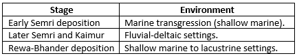
Overall shift from marine to terrestrial environments over time.
Age of Vindhyan Succession
- Estimated Age: ~1.7 Ga to 600 Ma (Mesoproterozoic to early Neoproterozoic).
- Dating Methods: U-Pb zircon dating, stromatolite biostratigraphy.
Examples: Bhimbetka Rock Shelters: Archaeological evidence of ancient habitation within Vindhyan rocks.
The Vindhyan Supergroup reflects a transition from marine to terrestrial depositional environments over a billion-year history, preserving crucial evidence of Earth’s early biosphere and tectonic settings.
(c) Describe briefly the characteristics of different types of aquifers and also discuss the important properties that an aquifer should possess. (15 Marks)
Ans: An aquifer is a body of permeable rock or sediment that stores and transmits groundwater. Understanding aquifer types and properties is fundamental for water resource management.
Types of Aquifers and Characteristics

Important Properties an Aquifer Should Possess
Porosity
Amount of pore space to store water.
Example: Sandstone (~25-30% porosity).
Permeability
Ability to transmit water through pores.
High permeability = better aquifer quality.
Transmissivity
Measure of how much water can move through a unit width of aquifer under a unit hydraulic gradient.
Storage Coefficient
Volume of water released or absorbed per unit area per unit change in hydraulic head.
Important for confined aquifers.
Hydraulic Conductivity
Rate of groundwater flow through an aquifer material under a hydraulic gradient.
Geological Theory
Theis (1935) developed a model for groundwater flow to wells based on aquifer properties like transmissivity and storage coefficient.
Examples
Indo-Gangetic Plain Aquifer: One of the world’s largest unconfined aquifers.
Dakshin Kannada coastal aquifers: Confined aquifers tapped for drinking water.
Aquifers vary based on geological structure and hydraulic behavior. Understanding their types and properties like porosity, permeability, and transmissivity is crucial for sustainable groundwater management.
Q7:
(a) Discuss the merits and limitations of different methods of stratigraphic analysis in brief. Comment on the most suitable method of stratigraphic analysis with justification. (20 Marks)
Ans: Stratigraphic analysis is crucial for reconstructing Earth's history, correlating rock units, and understanding past environments. Various methods exist, each with specific merits and limitations.
Different Methods of Stratigraphic Analysis
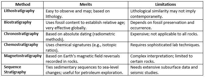
Most Suitable Method
Biostratigraphy is often considered the most versatile and widely applicable method.
Justification:
Fossils like ammonites, foraminifera, and trilobites are widespread, easily recognizable, and rapidly evolving.
Ideal for correlating strata over large geographical areas.
Supported by standard biozones recognized internationally.
Example: Global boundary stratotype sections and points (GSSPs) use biostratigraphic markers to define geological time boundaries.
Theoretical Contributions: William Smith (1815): Father of stratigraphy, introduced the principle of faunal succession.
While each stratigraphic method has specific applications, biostratigraphy remains the most practical and widely used method due to its global applicability and ease of use, especially when integrated with other methods for higher accuracy.
(b) Describe in brief various types of organic-walled microfossils. Add a note on their biostratigraphic and paleogeographic significance. (15 Marks)
Ans: Organic-walled microfossils are microscopic fossils with organic (carbonaceous) walls. They provide important clues about ancient life, environments, and global correlations.
Types of Organic-Walled Microfossils
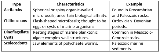
Biostratigraphic Significance
- Useful in zoning and correlation of sedimentary sequences.
- Aid in defining biozones (e.g., dinocyst zones in Cretaceous sediments).
- Help date non-fossiliferous (poorly macrofossiliferous) sediments.
Paleogeographic Significance
- Distribution patterns of dinoflagellate cysts indicate past sea surface temperatures and oceanic circulation patterns.
- Help in reconstructing continental drift and paleo-oceanography.
Example: Acritarch assemblages from the Proterozoic help trace the evolution of early life and changing environments.
Theoretical Contribution: Evitt (1963) emphasized the use of dinoflagellate cysts in stratigraphic studies.
Organic-walled microfossils are invaluable tools for biostratigraphy and paleogeography, particularly in marine sequences where other fossils are rare or absent.
(c) Describe the types of geological investigation required before construction of a highway in the Himalayas. (15 Marks)
Ans: Highway construction in the Himalayas requires thorough geological investigations due to steep gradients, active tectonics, landslides, and fragile ecosystems.
Types of Geological Investigation
Geomorphological Study
Identification of landslide-prone zones, fault lines, river terraces.
Mapping of slope stability zones.
Geotechnical Investigation
Soil and rock sampling for testing strength, porosity, permeability.
Borehole drilling and Standard Penetration Test (SPT).
Seismological Study
Assessing seismic hazard zones.
Fault mapping and determining earthquake recurrence intervals.
Hydrogeological Investigation
Study of groundwater conditions.
Identification of seepage areas that may trigger slope failures.
Remote Sensing and GIS Analysis
Satellite imagery for terrain analysis.
Use of digital elevation models (DEMs) for slope mapping.
Structural Geological Study
Mapping folds, faults, thrusts.
Important in the Himalayas where thrust faults like the Main Boundary Thrust (MBT) influence slope stability.
Environmental Impact Assessment (EIA)
Assessment of the project's impact on forests, wildlife, and water bodies.
Ensuring sustainable practices.
Example: During construction of the Char Dham Highway Project, extensive geotechnical and slope stability investigations were conducted to minimize risks of landslides and erosion.
Theoretical Contribution: Arnold Heim’s studies on Himalayan geology emphasized the importance of understanding tectonic structures before any engineering activities.
Comprehensive geological investigations are critical for safe and sustainable highway construction in the Himalayas. It ensures slope stability, minimizes landslide risks, and preserves ecological balance.
Q8:
(a) Explain the concept of drainage basin morphometry. How do morphometric parameters influence the groundwater conditions of an area? (20 Marks)
Ans: Drainage basin morphometry refers to the quantitative measurement and mathematical analysis of the earth’s surface features (landforms) related to drainage patterns. It includes evaluating aspects like basin area, stream length, stream order, slope, and shape, which impact runoff, infiltration, and groundwater recharge.
Concept of Drainage Basin Morphometry
- Defined by: Horton (1945) and further developed by Strahler (1952).
- Aims to quantitatively describe the shape, size, and texture of a river basin.
- Main parameters:
Linear Aspects: Stream order, stream length, bifurcation ratio.
Areal Aspects: Basin area, drainage density, stream frequency.
Relief Aspects: Basin relief, ruggedness number, slope.
Key Morphometric Parameters and Their Influence on Groundwater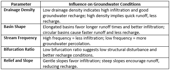 Example: Indo-Gangetic plains: Low drainage density and gentle slope lead to excellent groundwater reservoirs.
Theoretical Contribution: Horton’s (1945) "Laws of Drainage Composition" laid the foundation for linking morphometry to hydrology.
Morphometric analysis of drainage basins is crucial for understanding groundwater potential. Low drainage density, low stream frequency, and gentle slopes favor better groundwater recharge, ensuring sustainable water availability.
(b) Discuss various modes of preservation of fossils. (15 Marks)
Ans: Fossils are the preserved remains or impressions of ancient organisms. The process of fossilization depends on environmental conditions and biological material, resulting in various modes of preservation.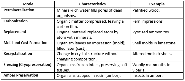
Example: Insects preserved in amber from the Cretaceous period provide detailed anatomical information.
Theoretical Contribution: Charles Darwin emphasized the importance of fossil preservation to understand the history of life but also pointed out the incompleteness of the fossil record.
ConclusionFossils can be preserved through various processes, each providing different levels of anatomical detail. Understanding modes of preservation helps paleontologists reconstruct ancient ecosystems and evolutionary histories.
(c) Discuss the evolution of the Himalayas. Illustrate your answer with suitable labelled sketches. (15 Marks)
Ans: The Himalayas, the highest mountain range in the world, have been formed through a complex process of tectonic plate movements and geological events over millions of years. The evolution of the Himalayas is a fascinating story of the Earth's dynamic forces at work.
Evolution of the Himalayas
The Himalayas, one of the youngest mountain ranges in the world, were formed due to the collision of the Indian Plate with the Eurasian Plate. This tectonic process began during the Late Cretaceous period and continues to evolve.
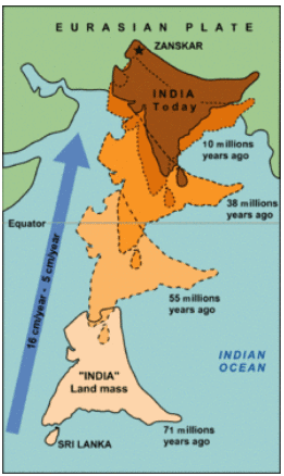
Key Stages of Evolution
- Pre-Collision Stage (Pre-70 Million Years Ago)
- Tethys Ocean: A vast ocean existed between the Indian Plate and the Eurasian Plate.
- Subduction: The Indian Plate moved northward, subducting beneath the Eurasian Plate.
- Initial Collision Stage (70–55 Million Years Ago)
- Continental Collision: The Indian Plate collided with the Eurasian Plate, causing the closure of the Tethys Ocean.
- Uplift Begins: Initial uplift of sediments deposited in the Tethys Ocean.
- Main Orogeny (55–23 Million Years Ago)
- Formation of Major Himalayan Ranges:
- Inner Himalayas (Greater Himalayas) formed first due to the thrusting and folding of deeper sediments.
- Middle Himalayas (Lesser Himalayas) uplifted subsequently.
- Major Fault Systems: Formation of Main Central Thrust (MCT) and Main Boundary Thrust (MBT).
- Formation of Major Himalayan Ranges:
- Post-Orogeny and Continued Uplift (23 Million Years Ago–Present)
- Ongoing Collision: Indian Plate continues to move northward, causing further uplift.
- Formation of Outer Himalayas (Siwaliks): Erosion and deposition from older ranges led to the creation of foothill ranges.
- Seismic Activity: Continued tectonic activity leads to earthquakes and further shaping of the region.
The evolution of the Himalayas is a testament to the power of tectonic forces and geological processes in shaping the Earth's surface. The ongoing collision of the Indian Plate with the Eurasian Plate continues to shape the Himalayas and the surrounding regions, making it one of the most dynamic and geologically active areas on the planet.
|
64 videos|135 docs
|
FAQs on UPSC Mains Answer PYQ 2024: Geology Paper 1 (Section- B) - Geology Optional for UPSC
| 1. What topics are commonly covered in the Geology Paper 1 of the UPSC Mains exam? |  |
| 2. How can I effectively prepare for the Geology Paper 1 of the UPSC Mains exam? | |
| 3. What is the marking scheme for the Geology Paper 1 in the UPSC Mains exam? | |
| 4. Are there any specific books recommended for studying Geology for the UPSC Mains exam? | |
| 5. What are the important practical skills required for Geology Paper 1 in UPSC Mains? | |


past year papers
,Objective type Questions
,UPSC Mains Answer PYQ 2024: Geology Paper 1 (Section- B) | Geology Optional for UPSC
,Viva Questions
,MCQs
,UPSC Mains Answer PYQ 2024: Geology Paper 1 (Section- B) | Geology Optional for UPSC
,Exam
,mock tests for examination
,video lectures
,practice quizzes
,shortcuts and tricks
,Free
,Summary
,Previous Year Questions with Solutions
,Important questions
,UPSC Mains Answer PYQ 2024: Geology Paper 1 (Section- B) | Geology Optional for UPSC
,Semester Notes
,Extra Questions
,Sample Paper
,ppt
,study material
;


UPSC Mains Answer PYQ 2024: Geology Paper 1 (Section- B) Free PDF Download
Importance of UPSC Mains Answer PYQ 2024: Geology Paper 1 (Section- B)
UPSC Mains Answer PYQ 2024: Geology Paper 1 (Section- B) Notes
UPSC Mains Answer PYQ 2024: Geology Paper 1 (Section- B) UPSC Questions
Study UPSC Mains Answer PYQ 2024: Geology Paper 1 (Section- B) on the App
|
© EduRev
|
Education Revolution
|


|


within 7 days!