Class 3 Exam > Class 3 Notes > Social Studies Class 3 ICSE > Chapter Notes: Locating Places on the Earth
Locating Places on the Earth Chapter Notes | Social Studies Class 3 ICSE PDF Download
| Table of contents |
|
| Introduction |
|
| The Model of the Earth: A Globe |
|
| Maps |
|
| Differences Between Globe and Map |
|
| Directions |
|
| Points To Remember |
|
| Glossary |
|

Introduction
In this chapter, we will learn how to find places on the Earth. We will know about tools like a globe, maps, and a compass that help us locate places. We will also learn about directions like north, south, east, and west, and how to use a sketch to find places around us. Let's explore how we can understand where different places are on our planet!
The Model of the Earth: A Globe
A globe is a small model of the Earth. It helps us understand the Earth and find places on it.
- The globe is round in shape, just like the Earth, and shows what the Earth looks like.
- It is fixed on a stand and tilted a little to show how the Earth is positioned in space around the Sun.
- The globe can spin at a point called the axis, which helps us know how the Earth spins.
- It shows us the continents, countries, oceans, and seas on the Earth.
Maps
- A globe is too small to show all the places on Earth in detail, and it is hard to carry around.
- So, we use maps to know the details of places.
- A map is a drawing of the Earth or a part of it on a flat surface, like paper.
- Maps help us find small towns, cities, and places that a globe cannot show because of its small size.
- Maps use different colours to show things like water bodies, lands, hillsindoors, hills, mountains, plains, and deserts.
- They also use signs and symbols to show things like roads, railways, and landmarks on all maps.
- A legend or key on the map explains what these symbols mean.
- Maps come in different sizes and can be hung on a wall or kept folded.
- A book of maps is called an atlas.
Fun Fact
Gerardus Mercator was the first man to draw a map of the Earth on a flat surface.
Types of Maps
Maps are mostly of two types:
- A political map shows the boundaries of states and countries, including cities and towns.
- A physical map shows natural features like land, mountains, valleys, rivers, lakes, and ponds.
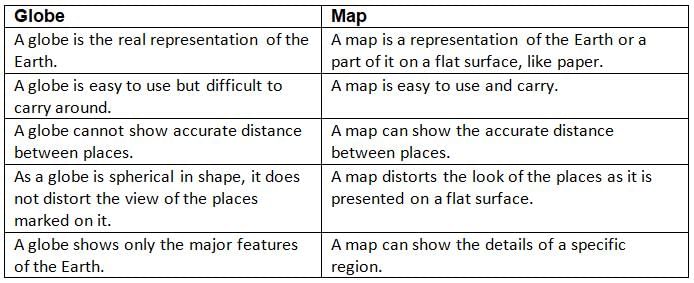
Differences Between Globe and Map
Directions
- Directions help us find any place on the Earth.
- There are four main directions: North, East, South, and West.
- The Sun rises in the east and sets in the west.
- If we stand facing the Sun in the morning (east), the direction behind us is west, our right hand points to the south, and our left hand points to the north.
- The bright Pole Star is always seen in the north at night and is also called the North Star.
- We can find other directions easily with the help of the North Star.
- There are four more directions between the main ones: North-east, North-west, South-east, and South-west.
- All these eight directions help us locate any place on the Earth easily.
Fun Fact
- Sailors in the olden days took the help of the North Star to find out directions. This is because the North Star does not change its position in the course of the night.
- People who make and study maps are called cartographers.
Compass
- A compass is a tool for finding directions; it is also called a mariner’s compass.
- It has a magnetic needle that helps us find the north direction.
- With the north direction, we can find other directions also.
- A compass has been used by sailors for a long time to find directions.
- Now, it is also used in the present time, especially while travelling by sea or air.
Direction on a Map
- A map of a country usually has an arrow drawn on the top, which points to the north direction.
- With the help of this north arrow, we can easily locate places that lie in different directions on the map.
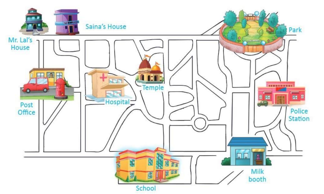
Sketch
- We also use a sketch to find the location of a place.
- A sketch is a rough drawing of a place; it is not an exact drawing.
- We use words like up, down, near, far, in front of, behind, and left or right to give simple directions using a sketch.
- For example, in a sketch: the park is behind the police station, Saina’s house is to the left of Mr Lal’s house, and the temple is near the hospital.
Points To Remember
- A globe is a model of the Earth and is used to study different places in the world.
- A map is drawn on a flat surface, like paper.
- Maps are mostly of two types: physical and political.
- East, west, north, and south are the four main directions.
- A compass and map help in finding directions, hence help in locating places.
- A sketch is a rough drawing of a place that also helps in locating places.
Glossary
- Globe: A small, round model of the Earth that shows continents and oceans.
- Map: A flat drawing of the Earth or a part of it, showing places like cities and rivers.
- Compass: A tool with a magnetic needle that helps find directions like north and south.
- Directions: Ways to find places, like north, south, east, and west.
- Sketch: A rough drawing of a place that helps us find locations using simple words.
The document Locating Places on the Earth Chapter Notes | Social Studies Class 3 ICSE is a part of the Class 3 Course Social Studies Class 3 ICSE.
All you need of Class 3 at this link: Class 3
|
58 docs|15 tests
|
FAQs on Locating Places on the Earth Chapter Notes - Social Studies Class 3 ICSE
| 1. What is the difference between a globe and a map? |  |
Ans. A globe is a three-dimensional representation of the Earth, which shows the actual shape of continents and oceans. It allows us to see the Earth as it really is, including the curvature of the planet. A map, on the other hand, is a two-dimensional representation and can depict specific areas in greater detail, often including roads, landmarks, and political boundaries. Maps can be flat and may not accurately represent the sizes and distances of places, while globes provide a more accurate overall view.
| 2. Why is it important to locate places on Earth? | |
Ans. Locating places on the Earth is crucial for various reasons, such as navigation, understanding geography, and planning travel or trade routes. It helps people to know where they are in relation to other places, facilitates communication and transportation, and enhances our understanding of different cultures and environments. Accurate location information is also essential for emergency services and disaster management.
| 3. How can we use globes, maps, and directions in our daily lives? | |
Ans. We can use globes to gain a better understanding of the world's geography and to visualize the relationships between different countries and continents. Maps can help us navigate our way around cities or rural areas, find specific locations, and understand the layout of our surroundings. Directions, whether given verbally or through written instructions, guide us in reaching our destinations efficiently and safely.
| 4. What are the main features of a map that help us understand it better? | |
Ans. The main features of a map include the title, which indicates what the map represents, the legend or key, which explains the symbols used on the map, and the scale, which shows the ratio of distance on the map to actual distance on the ground. Additionally, maps often include compass roses to indicate direction, and labels for important places, making it easier for us to interpret the information presented.
| 5. What tools can we use to find directions when we are lost? | |
Ans. When we are lost, we can use several tools to find directions. A physical map can be very helpful, especially if we can identify our location and the surrounding area. A compass can help us determine which way is north. Additionally, we can use a smartphone or GPS device, which provides real-time directions and can guide us to our destination. Asking locals for directions is also a useful strategy in unfamiliar places.
About this Document

4.79/5
Rating

Oct 04, 2025
Last updated
Related Exams
Document Description: Chapter Notes: Locating Places on the Earth for Class 3 2025 is part of Social Studies Class 3 ICSE preparation.
The notes and questions for Chapter Notes: Locating Places on the Earth have been prepared according to the Class 3 exam syllabus. Information about Chapter Notes: Locating Places on the Earth covers topics
like Introduction, The Model of the Earth: A Globe, Maps, Differences Between Globe and Map, Directions, Points To Remember, Glossary and Chapter Notes: Locating Places on the Earth Example, for Class 3 2025 Exam. Find important definitions, questions, notes, meanings, examples, exercises and tests below for Chapter Notes: Locating Places on the Earth.
Introduction of Chapter Notes: Locating Places on the Earth in English is available as part of our Social Studies Class 3 ICSE
for Class 3 & Chapter Notes: Locating Places on the Earth in Hindi for Social Studies Class 3 ICSE course.
Download more important topics related with notes, lectures and mock test series for Class 3
Exam by signing up for free. Class 3: Locating Places on the Earth Chapter Notes | Social Studies Class 3 ICSE
Description
Full syllabus notes, lecture & questions for Locating Places on the Earth Chapter Notes | Social Studies Class 3 ICSE - Class 3 | Plus excerises question with solution to help you revise complete syllabus for Social Studies Class 3 ICSE | Best notes, free PDF download
Information about Chapter Notes: Locating Places on the Earth
In this doc you can find the meaning of Chapter Notes: Locating Places on the Earth defined & explained in the simplest way possible. Besides explaining types of
Chapter Notes: Locating Places on the Earth theory, EduRev gives you an ample number of questions to practice Chapter Notes: Locating Places on the Earth tests, examples and also practice Class 3
tests
Related Searches
study material
,Objective type Questions
,video lectures
,mock tests for examination
,Important questions
,past year papers
,MCQs
,Locating Places on the Earth Chapter Notes | Social Studies Class 3 ICSE
,ppt
,Free
,Viva Questions
,Summary
,shortcuts and tricks
,Sample Paper
,practice quizzes
,Previous Year Questions with Solutions
,Locating Places on the Earth Chapter Notes | Social Studies Class 3 ICSE
,Locating Places on the Earth Chapter Notes | Social Studies Class 3 ICSE
,Semester Notes
,Extra Questions
,Exam
;


Additional Information about Chapter Notes: Locating Places on the Earth for Class 3 Preparation
Chapter Notes: Locating Places on the Earth Free PDF Download
The Chapter Notes: Locating Places on the Earth is an invaluable resource that delves deep into the core of the Class 3 exam.
These study notes are curated by experts and cover all the essential topics and concepts, making your preparation more efficient and effective.
With the help of these notes, you can grasp complex subjects quickly, revise important points easily,
and reinforce your understanding of key concepts. The study notes are presented in a concise and easy-to-understand manner,
allowing you to optimize your learning process. Whether you're looking for best-recommended books, sample papers, study material,
or toppers' notes, this PDF has got you covered. Download the Chapter Notes: Locating Places on the Earth now and kickstart your journey towards success in the Class 3 exam.
Importance of Chapter Notes: Locating Places on the Earth
The importance of Chapter Notes: Locating Places on the Earth cannot be overstated, especially for Class 3 aspirants.
This document holds the key to success in the Class 3 exam.
It offers a detailed understanding of the concept, providing invaluable insights into the topic.
By knowing the concepts well in advance, students can plan their preparation effectively.
Utilize this indispensable guide for a well-rounded preparation and achieve your desired results.
Chapter Notes: Locating Places on the Earth
Chapter Notes: Locating Places on the Earth Notes offer in-depth insights into the specific topic to help you master it with ease.
This comprehensive document covers all aspects related to Chapter Notes: Locating Places on the Earth.
It includes detailed information about the exam syllabus, recommended books, and study materials for a well-rounded preparation.
Practice papers and question papers enable you to assess your progress effectively.
Additionally, the paper analysis provides valuable tips for tackling the exam strategically.
Access to Toppers' notes gives you an edge in understanding complex concepts.
Whether you're a beginner or aiming for advanced proficiency, Chapter Notes: Locating Places on the Earth Notes on EduRev are your ultimate resource for success.
Chapter Notes: Locating Places on the Earth Class 3 Questions
The "Chapter Notes: Locating Places on the Earth Class 3 Questions" guide is a valuable resource for all aspiring students preparing for the
Class 3 exam. It focuses on providing a wide range of practice questions to help students gauge
their understanding of the exam topics. These questions cover the entire syllabus, ensuring comprehensive preparation.
The guide includes previous years' question papers for students to familiarize themselves with the exam's format and difficulty level.
Additionally, it offers subject-specific question banks, allowing students to focus on weak areas and improve their performance.
Study Chapter Notes: Locating Places on the Earth on the App
Students of Class 3 can study Chapter Notes: Locating Places on the Earth alongwith tests & analysis from the EduRev app,
which will help them while preparing for their exam. Apart from the Chapter Notes: Locating Places on the Earth,
students can also utilize the EduRev App for other study materials such as previous year question papers, syllabus, important questions, etc.
The EduRev App will make your learning easier as you can access it from anywhere you want.
The content of Chapter Notes: Locating Places on the Earth is prepared as per the latest Class 3 syllabus.
|
© EduRev
|
Education Revolution
|


|


Signup on EduRev and stay on top of your study goals
10M+ students crushing their study goals daily