UPSC Exam > UPSC Notes > Geography for UPSC CSE > Cheat Sheet: Drainage Systems
Cheat Sheet: Drainage Systems | Geography for UPSC CSE PDF Download

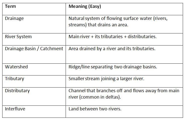
Key Terms (Flash Recall)
Drainage Patterns
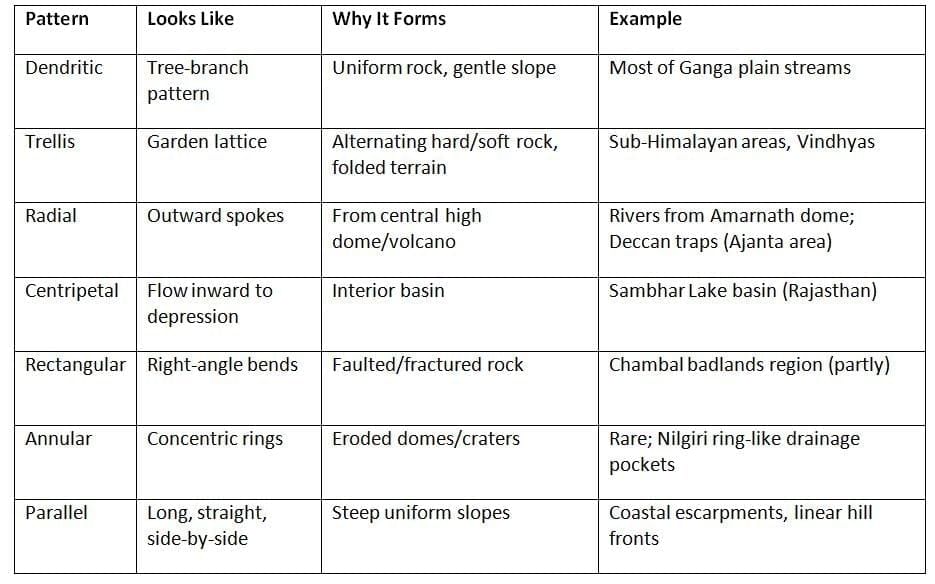
Prelims Tip: If options say “Alternating hard & soft strata” → mark Trellis.
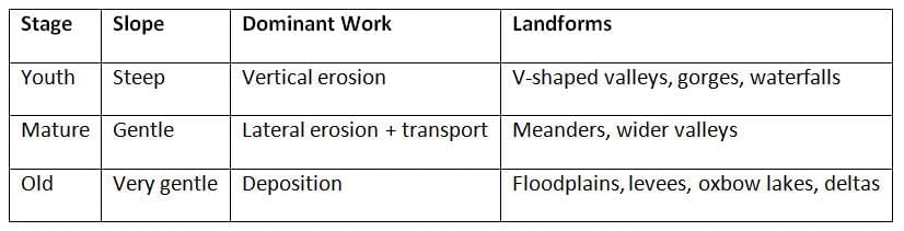
River Course Stages (Youth → Maturity → Old Age)
Classification of Indian Drainage
A. By Origin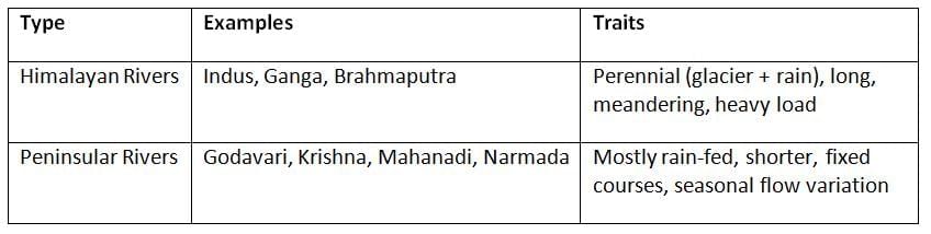
B. By Flow Direction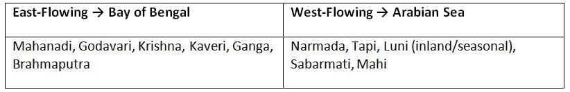
Mnemonic (East-flowing Peninsular): “Ma-Go-Kri-Ka” = Mahanadi–Godavari–Krishna–Kaveri.
Major River Systems of India
Indus System (Himalayan; International)
- Origin: Tibetan Plateau (Lake Mansarovar region).
- Flows through: Ladakh → Pakistan → Arabian Sea (Karachi coast).
- Main Tributaries (J & K / Punjab): Jhelum, Chenab (Jhelum+Ravi+Beas?), Ravi, Beas, Sutlej.
- Use in Exams: Indus Water Treaty; western rivers.
Ganga System
- Origin: Gangotri Glacier (Bhagirathi) + Alaknanda confluence at Devprayag = Ganga.
- Key Tributaries (L to R across plains): Yamuna, Ramganga, Ghaghara, Gandak, Kosi (flood-prone), Son.
- Delta Creation: With Brahmaputra → Sundarbans (world’s largest delta).
- Cultural hot belt: Haridwar, Varanasi, Prayagraj.
Brahmaputra System
- Upper Course Name: Yarlung Tsangpo (Tibet).
- U-turn: Enters Arunachal as Siang/Dihang, joins Dibang & Lohit → Brahmaputra (Assam).
- Nature: Braided, huge silt load, devastating floods.
- Delta with Ganga: Bangladesh (as Jamuna-Padma-Meghna system).
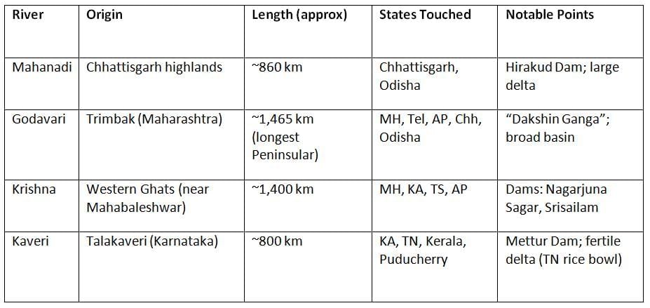
Peninsular Rivers (East-Flowing)
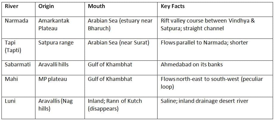
Peninsular Rivers (West-Flowing)
Inland Drainage in India
- Occurs where rivers do not reach the sea.
- Common in arid Rajasthan (Luni, Ghaggar-Hakra paleo-channel).
- Salt lakes form (e.g., Sambhar Lake).
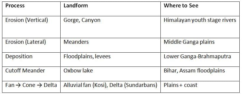
River Processes & Associated Landforms)
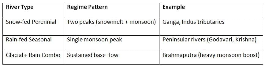
River Regime (Flow Variation Through Year)
The document Cheat Sheet: Drainage Systems | Geography for UPSC CSE is a part of the UPSC Course Geography for UPSC CSE.
All you need of UPSC at this link: UPSC
|
175 videos|624 docs|192 tests
|
FAQs on Cheat Sheet: Drainage Systems - Geography for UPSC CSE
| 1. What are the different types of drainage patterns and their significance in geomorphology? |  |
Ans.Drainage patterns refer to the arrangement of a river and its tributaries in a landscape. Common types include dendritic (tree-like), radial (spreading from a central point), rectangular (formed by jointed rock), and trellis (developing in areas with alternately resistant and less resistant rocks). These patterns are significant as they provide insights into the geological structure, topography, and hydrology of an area.
| 2. What are the stages of a river's course, and how do they affect the landscape? | |
Ans.A river typically undergoes three stages: youth, maturity, and old age. In the youth stage, rivers have steep gradients, leading to rapid flow and erosion, forming V-shaped valleys. The maturity stage sees a reduction in gradient, resulting in meanders and wider valleys. In old age, the river features slow flow, extensive meandering, and features like oxbow lakes, with significant sediment deposition. Each stage shapes the landscape differently, affecting ecosystems and human settlement.
| 3. How are Indian rivers classified based on their drainage systems? | |
Ans.Indian rivers can be classified into two main categories: the Himalayan rivers and the Peninsular rivers. Himalayan rivers, such as the Ganga and Brahmaputra, are perennial and have a significant flow throughout the year. Peninsular rivers, including the Godavari and Krishna, are seasonal and often experience variations in flow. This classification is critical for understanding water resource management and regional geography.
| 4. What distinguishes east-flowing and west-flowing rivers in the Peninsular region of India? | |
Ans.East-flowing rivers, like the Mahanadi and Godavari, generally drain into the Bay of Bengal and have a longer course with rich alluvial plains. In contrast, west-flowing rivers, such as the Narmada and Tapi, drain into the Arabian Sea and often create rift valleys. The differences in flow direction influence the ecological and economic characteristics of the regions they traverse.
| 5. What is inland drainage, and how does it occur in India? | |
Ans.Inland drainage refers to the phenomenon where rivers do not reach the sea but instead end in lakes or swamps. In India, this occurs in regions like the Thar Desert and parts of the Deccan Plateau, where rivers like the Luni flow into salt marshes. This drainage pattern is significant for understanding local hydrology, climate, and ecological adaptations in arid regions.
About this Document

4.76/5
Rating

Sep 22, 2025
Last updated
Related Exams
Document Description: Cheat Sheet: Drainage Systems for UPSC 2025 is part of Geography for UPSC CSE preparation.
The notes and questions for Cheat Sheet: Drainage Systems have been prepared according to the UPSC exam syllabus. Information about Cheat Sheet: Drainage Systems covers topics
like Key Terms (Flash Recall), Drainage Patterns , River Course Stages (Youth → Maturity → Old Age), Classification of Indian Drainage, Major River Systems of India , Peninsular Rivers (East-Flowing), Peninsular Rivers (West-Flowing), Inland Drainage in India, River Processes & Associated Landforms), River Regime (Flow Variation Through Year) and Cheat Sheet: Drainage Systems Example, for UPSC 2025 Exam. Find important definitions, questions, notes, meanings, examples, exercises and tests below for Cheat Sheet: Drainage Systems.
Introduction of Cheat Sheet: Drainage Systems in English is available as part of our Geography for UPSC CSE
for UPSC & Cheat Sheet: Drainage Systems in Hindi for Geography for UPSC CSE course.
Download more important topics related with notes, lectures and mock test series for UPSC
Exam by signing up for free. UPSC: Cheat Sheet: Drainage Systems | Geography for UPSC CSE
Description
Full syllabus notes, lecture & questions for Cheat Sheet: Drainage Systems | Geography for UPSC CSE - UPSC | Plus excerises question with solution to help you revise complete syllabus for Geography for UPSC CSE | Best notes, free PDF download
Information about Cheat Sheet: Drainage Systems
In this doc you can find the meaning of Cheat Sheet: Drainage Systems defined & explained in the simplest way possible. Besides explaining types of
Cheat Sheet: Drainage Systems theory, EduRev gives you an ample number of questions to practice Cheat Sheet: Drainage Systems tests, examples and also practice UPSC
tests

Related Searches
video lectures
,shortcuts and tricks
,Summary
,Free
,Cheat Sheet: Drainage Systems | Geography for UPSC CSE
,MCQs
,Viva Questions
,past year papers
,Previous Year Questions with Solutions
,Cheat Sheet: Drainage Systems | Geography for UPSC CSE
,Sample Paper
,Extra Questions
,mock tests for examination
,Semester Notes
,Objective type Questions
,Cheat Sheet: Drainage Systems | Geography for UPSC CSE
,Exam
,ppt
,study material
,practice quizzes
,Important questions
;


Additional Information about Cheat Sheet: Drainage Systems for UPSC Preparation
Cheat Sheet: Drainage Systems Free PDF Download
The Cheat Sheet: Drainage Systems is an invaluable resource that delves deep into the core of the UPSC exam.
These study notes are curated by experts and cover all the essential topics and concepts, making your preparation more efficient and effective.
With the help of these notes, you can grasp complex subjects quickly, revise important points easily,
and reinforce your understanding of key concepts. The study notes are presented in a concise and easy-to-understand manner,
allowing you to optimize your learning process. Whether you're looking for best-recommended books, sample papers, study material,
or toppers' notes, this PDF has got you covered. Download the Cheat Sheet: Drainage Systems now and kickstart your journey towards success in the UPSC exam.
Importance of Cheat Sheet: Drainage Systems
The importance of Cheat Sheet: Drainage Systems cannot be overstated, especially for UPSC aspirants.
This document holds the key to success in the UPSC exam.
It offers a detailed understanding of the concept, providing invaluable insights into the topic.
By knowing the concepts well in advance, students can plan their preparation effectively.
Utilize this indispensable guide for a well-rounded preparation and achieve your desired results.
Cheat Sheet: Drainage Systems Notes
Cheat Sheet: Drainage Systems Notes offer in-depth insights into the specific topic to help you master it with ease.
This comprehensive document covers all aspects related to Cheat Sheet: Drainage Systems.
It includes detailed information about the exam syllabus, recommended books, and study materials for a well-rounded preparation.
Practice papers and question papers enable you to assess your progress effectively.
Additionally, the paper analysis provides valuable tips for tackling the exam strategically.
Access to Toppers' notes gives you an edge in understanding complex concepts.
Whether you're a beginner or aiming for advanced proficiency, Cheat Sheet: Drainage Systems Notes on EduRev are your ultimate resource for success.
Cheat Sheet: Drainage Systems UPSC Questions
The "Cheat Sheet: Drainage Systems UPSC Questions" guide is a valuable resource for all aspiring students preparing for the
UPSC exam. It focuses on providing a wide range of practice questions to help students gauge
their understanding of the exam topics. These questions cover the entire syllabus, ensuring comprehensive preparation.
The guide includes previous years' question papers for students to familiarize themselves with the exam's format and difficulty level.
Additionally, it offers subject-specific question banks, allowing students to focus on weak areas and improve their performance.
Study Cheat Sheet: Drainage Systems on the App
Students of UPSC can study Cheat Sheet: Drainage Systems alongwith tests & analysis from the EduRev app,
which will help them while preparing for their exam. Apart from the Cheat Sheet: Drainage Systems,
students can also utilize the EduRev App for other study materials such as previous year question papers, syllabus, important questions, etc.
The EduRev App will make your learning easier as you can access it from anywhere you want.
The content of Cheat Sheet: Drainage Systems is prepared as per the latest UPSC syllabus.
|
© EduRev
|
Education Revolution
|


|


Signup on EduRev and stay on top of your study goals
10M+ students crushing their study goals daily