Planning and Sustainable Development in Indian Context Class 12 Geography

Introduction
Planning involves the process of thinking, formulating a scheme or program, and implementing a set of actions to achieve a goal. It is a deliberate method used for preparation, such as for exams or travel. In the context of economic development, planning differs from traditional hit-and-miss methods and includes structured approaches to reforms and reconstruction.

There are two main approaches to planning:
Sectoral Planning:
- Focuses on the development of specific sectors within the economy.
- Examples include agriculture, irrigation, manufacturing, power, construction, transport, communication, social infrastructure, and services.
Regional Planning:
- Addresses the uneven economic development across different areas within a country.
- Aims to reduce regional imbalances by taking a spatial perspective and creating plans to develop less developed areas.
Target Area Planning
- The main objective of the planning process is to promote the development of economically disadvantaged areas. It is crucial to have access to resources, technology, and investment to ensure proper economic development in a region. However, even resource-rich regions may remain underdeveloped.
- Despite more than a decade of planning experience, there are still significant regional imbalances in economic development. To address both regional and social disparities, the Planning Commission has introduced the "Target Area" and "Target Group" approaches to planning.
Some of the programmes which are directed towards the development of these two approaches are as follows:
Target Area Programmes
- The "Target Area" approach to planning includes specific programs aimed at promoting development in certain areas.
- The Command Area Development Program targets development in specific regions.
- The Drought Prone Area Development Program focuses on areas susceptible to drought.
- The Desert Development Program is designed for regions classified as deserts.
- The Hill Area Development Program concentrates on development initiatives in hilly regions.
Target Group Programmes
- The "Target Group" approach to planning includes programs designed to support specific groups, such as the Small Farmers Development Agency (SFDA) and the Marginal Farmers Development Agency (MFDA).
- In the Eighth Five Year Plan, special area programs were implemented to focus on the development of hill areas, North-Eastern states, tribal areas, and other backward regions.
Hill Area Development Programme
- The Fifth Five Year Plan identified 15 districts that include all hilly districts of Uttar Pradesh (now Uttarakhand), Mikir hill, and North Cachar hills of Assam, Darjeeling district of West Bengal, and Nilgiri district of Tamil Nadu for development.
- In 1981, the National Committee on the Development of Backward Areas recommended that hill areas above 600m and not included in the tribal sub-plan be recognized as backward hill areas.
- The main objectives of the program were to promote the development of horticulture, plantation agriculture, animal husbandry, poultry, forestry, and small-scale and village industries to enable the utilization of local resources.
- The plans were developed in accordance with the topographical, ecological, economic, and social conditions of the hill areas.
Drought Prone Area Programme (DPAP)
- The programme initiated during the Fourth Five Year Plan aimed at providing employment in drought-affected regions while creating valuable assets.
- Initially, it emphasized labour-intensive civil projects but later expanded to include irrigation, land development, reforestation, grassland enhancement, and basic rural infrastructure such as electricity, roads, markets, and credit services.
- A review by the National Committee on Development of Backward Areas highlighted the programme's focus on agriculture and related sectors to restore ecological balance.
- With rising population pressures leading to the exploitation of marginal lands, there is a pressing need for diverse job opportunities in drought-affected areas.
- The integrated watershed development approach at the micro-level has been suggested as a strategy for developing these regions.
Identification of Drought-Prone Districts
- The Planning Commission of India in 1967 identified 67 districts vulnerable to drought.
- The Irrigation Commission in 1972 established a criterion of 30 per cent irrigated area to define drought-prone regions.
Drought-Affected Regions in India
- Drought-affected areas typically include the semi-arid and arid regions of Rajasthan, Gujarat, Western Madhya Pradesh, Marathwada in Maharashtra, Rayalaseema and Telangana plateaus in Andhra Pradesh, Karnataka plateau and highlands, and parts of Tamil Nadu.
- Regions in Punjab, Haryana, and north Rajasthan are largely safeguarded due to irrigation facilities.
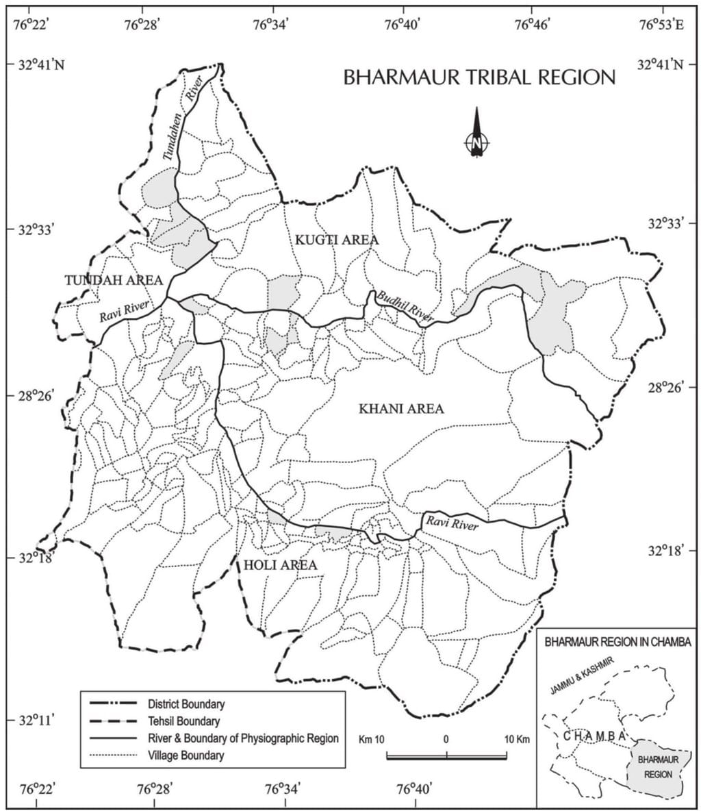
Case Study – Integrated Tribal Development Project in Bharmaur Region
The Bharmaur tribal area, comprising Bharmaur and Holi tehsils in Chamba district, Himachal Pradesh, has been recognized as a tribal area since November 21, 1975. The Gaddi community, known for their transhumance practices and speaking the Gaddiali dialect, inhabits this region. Development efforts commenced in the 1970s when the Gaddi community was classified as 'scheduled tribes,' and the area was designated as an Integrated Tribal Development Project (ITDP) under the Fifth Five Year Plan.
Objectives of the ITDP
- The ITDP aimed to improve the quality of life by enhancing transport, communication, agriculture, and social services.
- Social indicators such as literacy rates, sex ratios, and child marriage prevalence showed significant improvements as a result of the ITDP.
Changes in Livelihood and Economy
- The Gaddi community traditionally relied on a subsistence economy focused on food grain and livestock production.
- Over the past thirty years, there has been an increase in the cultivation of pulses and cash crops, although farming practices remain traditional.
- The significance of pastoralism has declined, with only a fraction of households continuing transhumance, while many Gaddis now migrate for wage labour during the winter months.
Sustainable Development
- Development refers to the condition of societies and the changes they undergo, influenced by the relationship between human societies and their environment, technology, and institutions. After World War II, development was primarily linked to economic growth, often measured by GNP and per capita income. However, this approach increased poverty due to the uneven distribution of resources.
- In the 1970s, the idea of development expanded to include redistribution with growth, as well as factors like well-being, living standards, health, education, equality of opportunity, and political and civil rights. By the 1980s, development came to mean an overall improvement in both social and material well-being for everyone.
- The term sustainable development arose from a growing environmental consciousness in the late 1960s, partly due to influential works like The Population Bomb (1968) and The Limits to Growth (1972). In response to rising global concerns about environmental issues, the United Nations set up the World Commission on Environment and Development (WCED), led by Norwegian Prime Minister Gro Harlem Brundtland. The Commission released the Brundtland Report, titled Our Common Future in 1987, which defines sustainable development as "meeting the needs of the present without compromising the ability of future generations to meet their own needs."
- Sustainable development considers ecological, social, and economic dimensions, aiming for a beneficial and lasting change in the economy, society, and the environment. It stresses the need to conserve resources for future generations and advocates for a multi-faceted approach to development.
- The idea of development has changed over the latter half of the twentieth century. While technology and institutions have enhanced human-environment interactions, they have also sped up technological advancements and changes in institutions. Hence, development signifies a thorough approach that combines economic growth with social fairness and environmental sustainability.
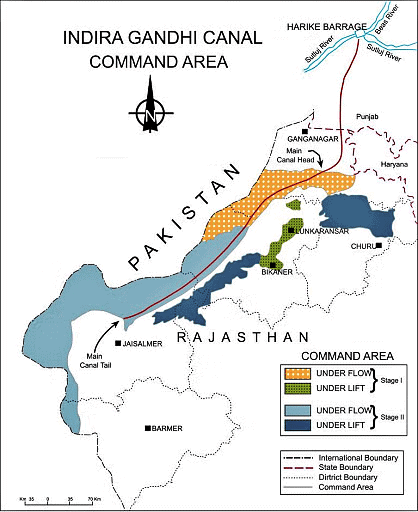
Case Study: Indira Gandhi Canal (Nahar) Command Area
The Indira Gandhi Canal, formerly known as the Rajasthan Canal, is among the largest canal systems in India. The idea for this canal system was proposed by Kanwar Sain in 1948, and the project was officially launched on March 31, 1958.
Canal Overview
- The canal starts at the Harike Barrage in Punjab and stretches parallel to the Pakistan border, approximately 40 kilometers away, through the Thar Desert (Marusthali) in Rajasthan.
- The entire planned length of the canal system is 9,060 kilometers, designed to irrigate a total culturable command area of 19.63 lakh hectares.
- Approximately 70 percent of this area is intended to be irrigated by a flow system, while the remaining 30 percent will use a lift system.
Stages of Construction
- The construction of the canal system has been divided into two stages.
- Stage-I includes the command area in Ganganagar, Hanumangarh, and the northern part of Bikaner districts, covering a culturable command area of 5.53 lakh hectares.
- This region has a gently undulating topography.
- Stage-II encompasses the command area in Bikaner, Jaisalmer, Barmer, Jodhpur, Nagaur, and Churu districts, with a culturable command area of 14.10 lakh hectares.
- This area consists of desert land characterized by shifting sand dunes, with summer temperatures reaching up to 50ºC.
Irrigation Systems
- In the Indira Gandhi Canal system, the lift canals are responsible for lifting water to irrigate areas where the land slopes upwards.
- All lift canals originate from the left bank of the main canal, while the canals on the right bank are flow channels.
- Stage-I of the canal system began receiving irrigation in the early 1960s, while Stage-II started receiving irrigation in the mid-1980s.
Environmental and Agricultural Impact
- The introduction of canal irrigation in this arid region has significantly transformed its ecology, economy, and society.
- It has had both positive and negative impacts on the environmental conditions of the area.
- Positive Effects:
- Increased soil moisture availability for extended periods.
- Successful afforestation and pasture development programs under the Command Area Development (CAD) initiatives have contributed to greening the land.
- Reduction in wind erosion and siltation of canal systems.
- Negative Effects:
- Intensive irrigation and excessive water use have led to serious problems of waterlogging and soil salinity.
Agricultural Transformation
- Canal irrigation has profoundly changed the agricultural landscape of the region.
- It has expanded the cultivated area and increased the intensity of cropping.
- Traditional crops such as gram, bajra, and jowar have been replaced by wheat, cotton, groundnut, and rice due to the availability of intensive irrigation.
- While this shift has initially boosted agricultural and livestock productivity, the long-term sustainability of agriculture is at risk due to issues like waterlogging and soil salinity.
Measures for Promotion of Sustainable Development
- The ecological sustainability of the Indira Gandhi Canal Project has been questioned due to the environmental degradation observed over the past four decades.
- Achieving sustainable development in the command area requires a strong focus on ecological measures.
 Measures
Strict Implementation of Water Management Policy:
- The canal project envisages protective irrigation in Stage-I and extensive irrigation of crops and pasture development in Stage-II.
- This involves carefully controlling water distribution to ensure efficient use and prevent wastage.
Appropriate Cropping Pattern:
- The cropping pattern should avoid water-intensive crops to conserve water.
- Encourage the cultivation of plantation crops such as citrus fruits, which require less water.
Effective Implementation of CAD Programmes:
- Programmes like lining of water courses, land development and levelling, and the warabandi system (equal distribution of canal water) should be effectively implemented.
- These measures reduce water conveyance loss and ensure that water reaches the intended areas efficiently.
Reclaiming Affected Areas:
- Areas affected by water logging and soil salinity should be reclaimed.
- This involves taking measures to restore the productivity of these lands and prevent further degradation.
Eco-Development Initiatives:
- Promote afforestation, shelterbelt plantation, and pasture development, especially in the fragile environment of Stage-II.
- These initiatives help in greening the land, reducing wind erosion, and improving the overall environmental quality.
Social Sustainability Support:
- Provide adequate financial and institutional support to land allottees from poor economic backgrounds for land cultivation.
- This helps them sustain their livelihoods and ensures that the benefits of the canal project are equitably distributed.
Economic Diversification:
- Economic sustainability in the region requires the development of not only agriculture and animal husbandry but also other sectors.
- Promote the diversification of the economic base and establish functional linkages between basic villages, agro-service centres, and market centres to create a robust and resilient local economy.
Conclusion
Planning is essential for achieving goals through strategic actions. Unlike traditional trial-and-error methods, planning employs structured approaches to tackle economic development, focusing on specific sectors and regions. Sustainable development balances economic growth with ecological and social needs, ensuring we meet present needs without compromising future generations.
|
50 videos|273 docs|37 tests
|
FAQs on Planning and Sustainable Development in Indian Context Class 12 Geography
| 1. What are the different approaches of planning? |  |
| 2. What is Target Area Planning? | |
| 3. What is Drought Prone Area Programme (DPAP)? | |
| 4. What is Sustainable Development? | |
| 5. What are the benefits of planning and sustainable development? | |


mock tests for examination
,Planning and Sustainable Development in Indian Context Class 12 Geography
,video lectures
,Free
,Summary
,Extra Questions
,Exam
,Semester Notes
,Objective type Questions
,study material
,practice quizzes
,ppt
,Important questions
,Sample Paper
,shortcuts and tricks
,Previous Year Questions with Solutions
,Planning and Sustainable Development in Indian Context Class 12 Geography
,MCQs
,Viva Questions
,Planning and Sustainable Development in Indian Context Class 12 Geography
,past year papers
;


Chapter Notes - Planning and Sustainable Development in Indian Context Free PDF Download
Importance of Chapter Notes - Planning and Sustainable Development in Indian Context
Chapter Notes - Planning and Sustainable Development in Indian Context
Chapter Notes - Planning and Sustainable Development in Indian Context Humanities/Arts Questions
Study Chapter Notes - Planning and Sustainable Development in Indian Context on the App
|
© EduRev
|
Education Revolution
|


|


