Class 9 Geography Chapter 1 Question Answers - Contemporary India - I

Q.1. What are jetstreams? How do they affect the climate? (Important)
Ans. Jetstreams are a narrow belt of high speed, high altitude, westerly winds in the troposphere. Jetstreams are an important component of the upper air circulation. They are located at an altitude of above 12000 metres. Their speed varies from 110 km/hr in summer to about 184 km/hr in winter. The most constant jetstreams identified are the mid-latitude and the subtropical jetstreams. Over India, jetstreams blow south of the Himalayas, all through the year except summer.
The western cyclonic disturbances are experienced in the north and northwestern parts of the country during winter months. They are brought in by the flow of westerly jetstream from the Mediterranean region.
In summer when the subtropical westerly jetstream moves north of the Himalayas, an easterly jetstream, called the tropical easterly jetstream blows over Peninsular India, approximately over 14°N latitude. Tropical cyclones that occur during the monsoons as well as in October- November are influenced by the tropical easterly jetstreams. The easterly flow brings tropical cyclones from the Bay of Bengal to the coastal regions of Orissa and Andhra Pradesh.
Q.2. What is the loo? How does it affect the weather of a place? (Important)
Ans. The strong, gusty, hot, dry winds blowing during the day over the north and northwestern India during summer are known as ‘loo’. The ‘loo’ is a striking feature of the hot weather season from April to June. Loo usually occurs during the afternoon but sometimes it even continues until late in the evening.
Direct exposure to these winds may even prove to be fatal. They cause acute dehydration and sunstroke. During May and June they sometimes bring duststorms which bring temporary relief as they lower the temperatures and may bring light rain and cool breeze.
Q.3. Write a short note on the retreating monsoons. (Important)
Ans. The months of October-November mark a period of transition from hot rainy season to cold dry winter conditions. This period is known as Retreating Monsoon or Transition season because the southwest monsoons weaken and withdraw or retreat from India. The retreat of monsoon is marked by clear skies and rise in temperature. While days are warm, nights are cool and pleasant. Owing to high temperature and high humidity, weather becomes oppressive. This phenomenon is known as ‘October heat’.
With the shift of low pressure centre to the Bay of Bengal in early November, cyclonic depressions originating over the Andaman Sea move over the Eastern Coast. The Coromandel coast receives bulk of its rainfall from the retreating monsoons. These tropical cyclones cause heavy destruction and torrential rains in thickly populated deltaic regions of Tamil Nadu and Andhra Pradesh.
Q.4. Describe with examples how altitude affects the climate of a place.
Ans. Altitude plays an important role in influencing the climate of a place. As one goes up to higher a0ltitudes away from the surface of the earth, the atmosphere becomes less dense and temperature decreases. As a result hill stations like Mussoorie, Darjeeling and Udagamandalam (Ooty) in the south are cooler even during summer.
The decrease in temperature with altitude also has its effects upon the pressure system which in turn determines the wind pattern and hence precipitation. Drass, Srinagar and Shimla, located on the higher slopes of the Himalayas, receive heavy snowfall during winter due to inflow of western disturbances to areas with sub-zero temperatures.
The lofty Himalayas, on account of their high altitude, stand as a barrier and protect India from bitterly cold winds of Central Asia during winter. They also confine the rainfall from the monsoons to the mainland of India.
Places at lower altitudes, mainly those along the coast like Mumbai, Chennai, Kolkata, have moderate climates.
Q.5. Describe with examples how distance from the sea influences the climate of a place?
Ans. The sea exerts a moderating influence on the climate of a place. Places like Mumbai, Chennai, Thiruvanthapuram, Kolkata located near the sea have equable climate or maritime climate with less difference between summer and winter temperatures. As the distance from the sea increases, its moderating influence decreases. Places away from the sea are said to have continental location. Continentality is marked by extreme weather conditions, i.e., very hot summer and very cold winter. For example, Delhi located in the interior of the country at a distance from the sea experiences an extreme type of climate.
Q.6. What form of precipitation does the upper part of the Himalayas receive and why?
Ans. The upper parts of the Himalayas have quite high altitude of around 6000 metres. Temperature is very low in these parts as temperature decreases with a rise in altitude. Precipitation takes place in the form of snowfall in all stations in the upper parts of the Himalayas due to freezing temperatures. For example, Drass located in Jammu and Kashmir records minus 45°C (–45°C) temperature on a winter night. Hence, precipitation in this region is in the form of snowfall. Srinagar in the valley of Kashmir, Shimla and Manali in Himachal Pradesh and other hill stations in the upper parts of Himalayas receive snowfall in winter due to inflow of western cyclonic disturbances from the west.
Q.7. Write a short note on the trade winds. What are the effects of trade winds on the climate of India?
Ans. The planetary winds blowing from the Sub-Tropical High Pressure Belts to the Equatorial Low Pressure Belt or Doldrums are termed as ‘Trade Winds’.
On account of the Laws of Deflection due to the Coriolis force, they blow as North-East Trade Winds in the Northern Hemisphere and as South-East Trade Winds in the Southern Hemisphere. The trade winds are the most permanent and regular of all planetary winds. They blow with great force in a constant direction.
India lies in the region of Northeasterly Trade Winds. As they originate and blow over land, the Northeasterly Trade Winds generally carry very little moisture. Therefore, they bring little or no rainfall. Hence, had trade winds been the only factor influencing India’s climate, India would have been an arid land.
In late summer low pressure condition over Northern Plains intensifies. This attracts the trade winds of the Southern Hemisphere. The Southeast Trade Winds originating over warm subtropical areas of southern oceans cross the equator and blow in a southwesterly direction to India. They are moisture laden and bring rainfall to India as southwest monsoon.
Q.8. Discuss why Mawsynram receives the highest rainfall in the world? (Important)
Ans. Mawsynram in Meghalaya is located on the southern ranges of the Khasi Hills. When the rain bearing winds from the Bay of Bengal branch of monsoons strike the Garo, Khasi and Jaintia hills, they cause very heavy rainfall in the northeastern states located here. As Mawsynram is located at a position perpendicular to the path of the rainbearing winds which enters the deep valley of the Khasi hills, it receives rainfall of about 1141 cm per year. Hence, Mawsynram receives the highest rainfall in the world. Rainfall occurs here for almost nine months of the year.
Q.9. What is the Coriolis force? Describe briefly its effect on the climate of the world.
Ans. An apparent force caused by the earth’s rotation is called the Coriolis force. The Coriolis force is responsible for deflecting the direction of the winds towards the right in the Northern Hemisphere and towards the left in the Southern Hemisphere. This is also known as ‘Ferrel’s Law’.
Under the effect of Coriolis force the trade winds moving from Sub-Tropical High Pressure belts to Equatorial Low Pressure belts become Northeast Trade Winds in the Northern Hemisphere and Southeast Trade Winds in Southern Hemisphere. As a result, they bring heavy rainfall to the east coast of continents within tropics after passing over oceans. As they are offshore on the west coast, these regions turn into hot deserts.
Westerly winds blowing from Sub-Tropical High to Temperate Low Pressure belts become the South-Westerlies in the Northern Hemisphere and the Northwesterlies in the Southern Hemisphers due to Coriolis force. They bring much precipitation to western coast of continents, mainly in Southern Hemisphere.
Q.10. Give reasons why the bulk of the rainfall is concentrated over a few months in India. (Important)
Ans. The major part of the annual precipitation of India is due to the southwest monsoons. The reasons behind concentration of rainfall over few months are as follows :
(a) By early June the low pressure zone over northern India intensifies and attracts the moisture laden Southwest monsoons. These onshore winds are the main source of rainfall in India. As they originate as southeast trade winds over warm subtropical southern oceans they bring abundant moisture.
(b) The advancing southwest monsoons strike the southern part of the peninsula in early June and by July, it has its sway over entire India. The duration of monsoon is between 100- 120 days from early June to mid-September. Bulk of the rainfall of India is concentrated within these months. This period is known as rainy season.
(c) The Arabian Sea branch and Bay of Bengal branch of monsoon bring heavy rainfall of over 400 cm in West Coast areas and northeastern states. Even dry areas like Rajasthan and Gujarat receive some rain.
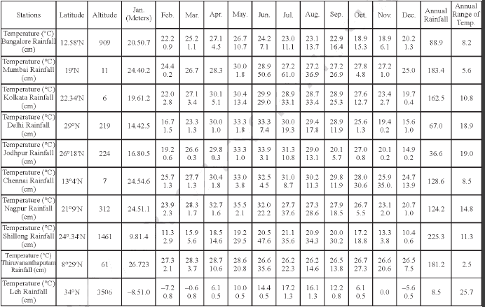
Q.11. Study the climate data of the given place and answer the following questions : (CBSE 2010)
(a) Find out the annual of temperature of the given place.
(b) Name the rainiest month.
(c) Which month receives least rainfall and how much ?
Ans. (a) Annual range of temperature = 27.1 – 18.9 = 8.2 °C
(b) September
(c) Jannuary receives the least rainfall = 7 mm.
Q.12. Read the given table and answer the following questions. (CBSE 2010)
(a) Name two rainiest stations
(b) Name the station farthest from equator
(c) Station which has highest range of temperature
Ans. (a) Two rainiest stations are Shillong (225.3 cm) and Mumbai (183.4 cm)
(b) Leh (34°N) is the farthest from the equator.
(c) Leh has the highest range of temperature (25.7°C)
Q.13. Study the climate data below and answer the questions. (CBSE 2010)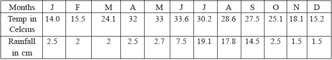
(a) Name the rainiest month of the year. What is the reading?
(b) What is meant by annual range of temperature?
(c) Which two months have the least rainfall?
Ans. (a) The rainiest month of the year is July (19.1 cm)
(b) Annual range of temperature = Maximum temperature – minimum temperature (in a year)
(c) November (1.5 cm) and December (1.5 cm) have the least rainfall.
Q.14. Study the climatic conditions of the two places and answer the following : (CBSE 2010)
(a) Name the place which receives the most rainfall in winter season and give reason for it.
(b) Name the place which receives maximum rainfall and how much?
(c) Name the place which has the lower range of temperature and how much.
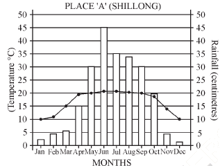
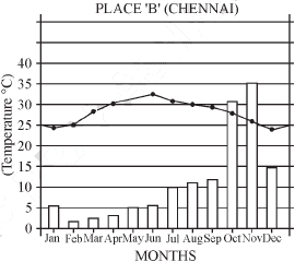
Ans. (a) Chemical receives the most rainfall in winter, due to Retreating Monsoons.
(b) Shillong receives the maximum rainfall.
Toral rainfall received in Shillong = 2 + 4 + 6 + 15 + 30 + 45 + 36 + 34 + 30 + 19 +
5 + 1 = 227 cm (approx)
(c) Range of temperature at Shillong = 20 – 10 = 10°C Range of temperature at Chennai =
33 – 24 = 9°C Hence, Chennai has a lower range of temperature.
Q.15. Study the climate data of the given place and answer the following questions
(CBSE 2010)
(a) Find out the annual range of temperature of the given place.
(b) Name the rainiest month.
(c) Which month receives the least rainfall and how much ?
Ans. (a) Annual range of temperature = 28.0 – 18.9 = 9.1°C
(b) September is the rainiest month.
(c) January receives the least rainfall (7 mm).
Q.16. What is the difference between weather and climate ? What kind of a climate does India have and why? (CBSE 2010)
Ans. Weather refers to the state of the atmosphere over an area at any point of time whereas climate refers to the sum total of weather conditions and variations over a large area for a long period of time. India has 'monsoon' type of climate. The climate of India is strongly influenced by monsoon winds.
Q. 17.

Study the climatic condition of Thiruvananthapuram and answer the following questions :
(CBSE 2010)
(a) Which two months receive the lowest rainfall?
(b) What is the range of temperature in the month of June?
(c) Which month receives the highest rainfall?
Ans. (a) January and February receive the lowest rainfall.
(b) Range of temperature in June = 31 – 24 = 7°C
(c) The month of June receives the highest rainfall.
Q.18. What is ITCZ? What is its significance? (CBSE 2010)
Ans. It is Inter-Tropical Convergence Zone. This is the equatorial trough normally positioned about 5°N of the equator, also known as the monsoon trough during the monsoon season.
Q.19. Study the data given below carefully and answer the following questions. [2011 (T-2)]

(19.1) Name the station which is farthest from the Equator.
(19.2) Name the driest and wettest station among the three stations.
Ans. (19.1) Delhi (29° N) (19.2) Nagpur (1242 mm) wettest station. Jodhpur (33.9 – 14.9 = 19°C) driest station.
Q.20. Study the following climatic data and answer the questions that follow : [2011 (T-2)]

(20.1) Name the rainiest month of the year. How much is the rainfall in this month?
(20.2) What is the annual range of temperature here?
(20.3) Name the hottest month and write the temperature.
Ans. (20.1) August is the rainiest month of the year. In August rainfall is 33.4 cm.
(20.2) Temperature 30.4° – 19.6 = 10.8°C
(20.3) May is the hottest month of the year (30.4°C)
Q.21. Why do western Ghats receive more rainfall than the Eastern Ghats. Explain briefly. [2011 (T-2)]
Ans. In terms of relief the western Ghats are much higher (900 – 1600 meter) in comparison to the Eastern Ghats (600 meter). The Western Ghats are continuous stretches of high mountains.Therefore, when the moisture ladden Arabian Sea branch of Southwest Monsoon first strikes the Western Ghats it brings heavy rainfall along the windward side of the Western Ghats. In Eastern Ghats, rainbearing winds of Southwest Monsoon do not face such orographic barrier and hence receive much lower amount of rainfall.
Q.22. What are western disturbances? How do they effect the climate of India? [2011 (T-2)]
Ans. The western cyclonic disturbances are weather phenomena of the winter months brought in by the westerly flow from the Mediterranean region. This phenomena usually influence the weather conditions of North and Northwestern regions of India. Tropical cyclones occur during October-November as a consequence of this western disturbances.
A characteristic feature of the cold weather season over the northern plains is the inflow of cyclonic disturbances from the west and the Northwest. These low pressure systems originate over the Mediterranean Sea and Western Asia and move into India along with the westerly flow. Under its influence cause the much needed rainfall over the plains and snowfalls in the mountains. The total amount of winter rainfall, locally known as Mahawat, is small but they are of immense value for the cultivation of rabi crops.
Q.23. Explain how monsoon acts as a unifying bond in the country. [2011 (T-2)]
OR
Why are the monsoons considered as a unifying bond? Explain.
OR
How do monsoon acts as a unifying bond for India? Explain.
Ans. The unifying influence of the monsoon on the Indian subcontinent is felt through its seasonal alternation of the wind systems and the associated weather conditions. It is also perceptible through uncertainties and uneven distribution of monsoon rainfall. The Indian landscape, its flora and fauna, agricultural seasons, livelihood of the people including festivals etc. are governed by the monsoon. Year after year people anxiously wait for the arrival of monsoon. The river valleys which carry monsoon water also unite the country as a single river valley unit.
Q.24. Define monsoon. Differentiate between 'Burst of the Monsoon' and 'Break of the Monsoon. [2011 (T-2)]
Ans. The word 'monsoon' is derived from the Arabic word 'mausim' which means season. It is basically a seasonal rain bearing winds, lasting for 100 – 120 days from early June to mid- September.
At the time of its arrival, the normal rainfall increases suddenly and continues constantly for several days. This is known as 'burst of the monsoon'. The phenomenon can be distinguished from the pre-monsoon showers.
Another phenomenon associated with the monsoon is its tendency to have breaks in rainfall. The monsoon rains take place only for a few days at a time. They are interspersed with rainless intervals. These breaks in monsoon are related to the movement of the monsoon trough.
|
55 videos|525 docs|78 tests
|
FAQs on Class 9 Geography Chapter 1 Question Answers - Contemporary India - I
| 1. What is climate change? |  |
| 2. How does climate change affect the environment? | |
| 3. What can we do to stop climate change? | |
| 4. How does climate change affect human health? | |
| 5. What is the Paris Agreement? | |


study material
,ppt
,MCQs
,Extra Questions
,Summary
,Viva Questions
,mock tests for examination
,Class 9 Geography Chapter 1 Question Answers - Contemporary India - I
,Sample Paper
,Important questions
,Semester Notes
,video lectures
,Class 9 Geography Chapter 1 Question Answers - Contemporary India - I
,practice quizzes
,Class 9 Geography Chapter 1 Question Answers - Contemporary India - I
,shortcuts and tricks
,Objective type Questions
,Previous Year Questions with Solutions
,Free
,past year papers
,Exam
;


Short Answer Questions - Climate Free PDF Download
Importance of Short Answer Questions - Climate
Short Answer Questions - Climate Notes
Short Answer Questions - Climate Class 9
Study Short Answer Questions - Climate on the App
|
© EduRev
|
Education Revolution
|


|


within 7 days!