Chapter Notes: Globe-Latitudes & Longitudes


Introduction
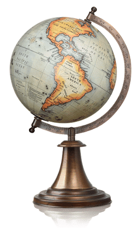
A globe is a true model of the Earth that shows the Earth's shape, lands, oceans distances and directions as they relate to one another truly. The globes are of varying sizes and types. Globe can be rotated in the same way as a top spin or potter's wheel is rotated.
 Globe
Globe
Axis: The imaginary line passing through the center of the Earth and joining the two points. A needle is fixed through the globe in a titled manner, which is called its axis.
Advantages of the Globe
- It shows the exact shape of the Earth
- It helps us to understand how day and night occur and seasons are caused.
- It gives the idea of the tilt of the Earth's axis.
- It shows us the exact position and areas of the continents and the oceans.
Disadvantages of the Globe
- It is difficult to carry it anywhere.
- Only a part of the Globe can be seen at a time.
- It cannot be used to study a specific part of the Earth.
- It does not show towns, cities, districts, roads, railways etc.
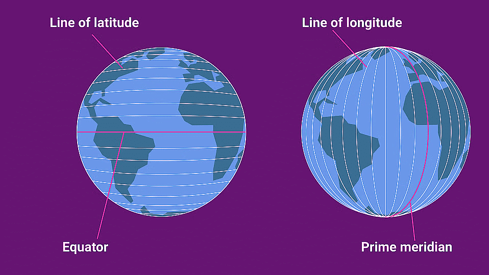
Equator
- It is the line that passes through the center of the Earth.
- It divides the Earth into two equal parts- The Northern Hemisphere and the Southern Hemisphere
- It has the largest Latitude at 0 degrees.
- It runs from east to west.
Important Parallels of Latitude
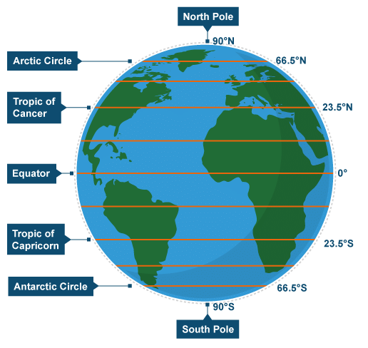 Important Parallels of Latitude
- Latitude is an unseen horizontal line encircling the Earth from East to West.
- All circles parallel to the Equator, extending from the Equator to the poles, are known as parallels of latitudes.
- The Equator itself signifies the zero-degree latitude and runs in an east-west direction.
- These lines measure the distance north or south from the Equator, running parallel to each other and never intersecting.
- They intersect the Prime Meridian at right angles and become shorter as they approach the poles.
Heat Zones of the Earth
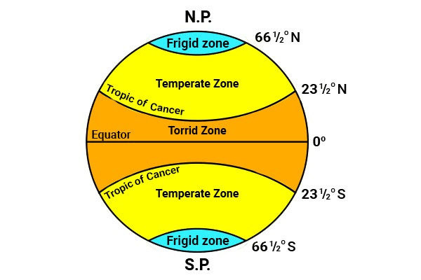 Different Heat Zones
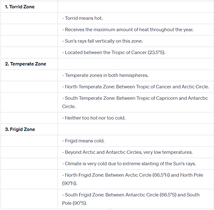 Features of different zones
What are Longitudes?
- Longitude is an invisible vertical line running around the Earth from North to South, with the Prime Meridian at 0°.
- Passing from Greenwich, the Prime Meridian traverses the United Kingdom, France, parts of Africa, and various seas, connecting different regions globally.
- The Prime Meridian's establishment in Greenwich is rooted in historical conventions, making it a global reference point for longitudinal measurements.
- Longitude divides the globe into Eastern and Western Hemispheres along the Prime Meridian.
- Examples of longitudes include New York at 74°W (West) and Cairo at 31°E (East).
 Longitudes and Latitudes
Longitude and Time
- Earth's daily rotation completes a full 360° cycle in 24 hours, equating to a movement of 15° per hour or 1° every 4 minutes.
- The Earth rotates from west to east, causing a 1-hour time advancement for every 15° eastward movement and a 1-hour delay for every 15° westward movement.
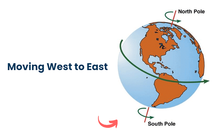
- Places to the east of Greenwich experience earlier sunrises, gaining time, while those to the west witness later sunrises, resulting in time loss.
- Calculating local time involves a straightforward addition or subtraction of the hour difference from the given longitude with respect to Greenwich Mean Time (G.M.T.).
- When the sun is at its zenith over the prime meridian in Greenwich, all locations along this line share mid-day or noon, serving as a global time synchronization reference.
Try yourself: What is the purpose of the Equator?
Time Zones
The time zone is defined by dividing the 360º of the earthly sphere into the 24 hours of the day. As a result, each time zone corresponds to 15º of the Earth's circumference and is the equivalent of 1 hour.
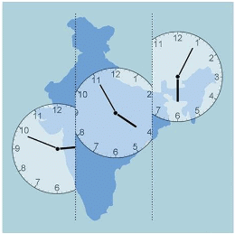 Time Zones of India
Why do we have Standard Time?
- Local times vary across different meridians, causing challenges in scheduling activities like train timetables.
- Standard time is essential for coordination, making it easier to plan and organize activities that span multiple longitudes.
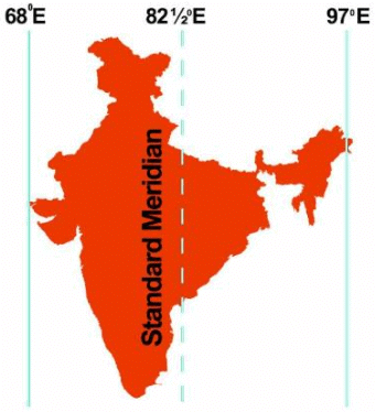 Indian standard maredian
- In India, the standard meridian is at 82½° E, known as Indian Standard Time (IST), providing a unified time reference for the entire country.
- Kabeer, near Bhopal, notes a time difference between India and England due to their respective longitudes.
- India, at 82°30'E, is 5 hours and 30 minutes ahead of GMT, leading to a 7:30 p.m. start for a cricket match in India when it is 2:00 p.m. noon in London.
- Some countries, like Russia, with extensive longitudinal spans, adopt multiple standard times.
- Earth is divided into twenty-four time zones, each covering 15° of longitude, facilitating global time coordination.
FAQs on Chapter Notes: Globe-Latitudes & Longitudes
| 1. What's the difference between latitude and longitude on a globe? |  |
| 2. How do you read latitude and longitude coordinates correctly? | |
| 3. Why is the equator at 0 degrees latitude and not somewhere else? | |
| 4. What's the difference between parallels and meridians, and why does it matter? | |
| 5. How many latitude and longitude lines are there on Earth, and why does the number matter? | |