NCERT Solutions for Class 9 Geography Chapter 3 - Drainage

Q1. Choose the right answer from the four alternatives given below.
(i) In which of the following states is the Wular Lake located?
(a) Rajasthan
(b) Uttar Pradesh
(c) Punjab
(d) Jammu and Kashmir
Ans: (d) Jammu and Kashmir state.
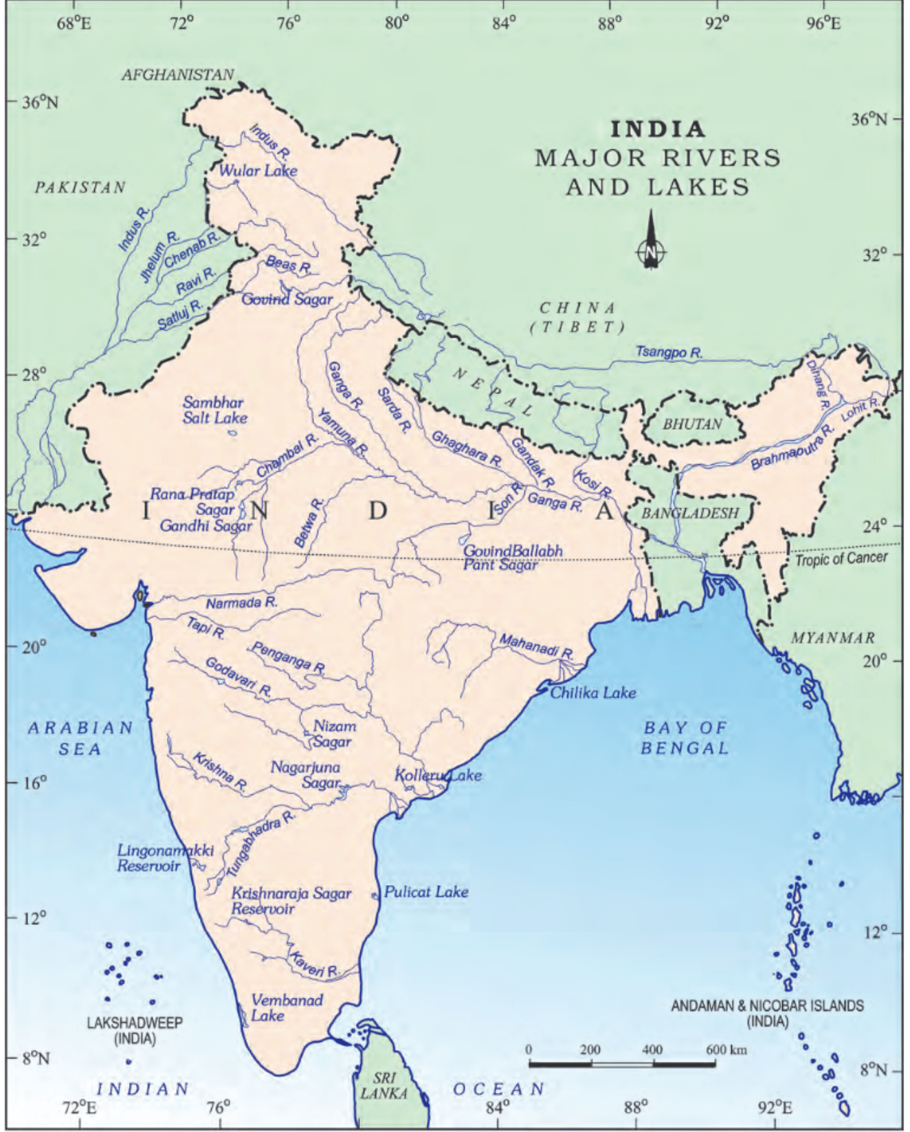
Wular lake is the largest freshwater lake in India and is situated in the Bandipora district of Jammu and Kashmir. The lake is surrounded by beautiful mountains and serves as an important habitat for various species of migratory birds.
(ii) The river Narmada has its source at
(a) Satpura
(b) Brahmagiri
(c) Amarkantak
(d) Slopes of the Western Ghats
Ans: (c) Amarkantak
Amarkantak is a pilgrimage site and a hill station located at the meeting point of the Vindhya and Satpura mountain ranges. Narmada is one of the longest rivers in India, spanning a length of approximately 1,312 kilometers. It is often referred to as the "lifeline of Madhya Pradesh" and is considered sacred by Hindus.
(iii) Which one of the following lakes is a salt water lake?
(a) Sambhar
(b) Dal
(c) Wular
(d) Gobind Sagar
Ans: (a) Sambhar
Sambhar Lake, located in the state of Rajasthan, India, is a saltwater lake. It is the largest inland saltwater lake in India and serves as a major source of salt production in the country.
(iv) Which one of the following is the longest river of the Peninsular India?
(a) Narmada
(b) Krishna
(c) Godavari
(d) Mahanadi
Ans: (c) Godavari
The Godavari River originates in the Western Ghats of Maharashtra and flows through the states of Maharashtra, Telangana, Andhra Pradesh, and eventually empties into the Bay of Bengal. The river stretches for about 1,465 kilometers (910 miles) in length, making it the longest river in Peninsular India.
(v) Which one amongst the following rivers flows through a rift valley?
(a) Mahanadi
(b) Tungabhadra
(c) Krishna
(d) Tapi
Ans: (d) Tapi
A rift valley is a long, narrow valley that is formed by the sinking and separation of the Earth's crust. The Tapi River originates in the Betul district of Madhya Pradesh and flows through Maharashtra and Gujarat before draining into the Arabian Sea.
Q2. Answer the following questions briefly.
(i) What is meant by a water divide? Give an example.
Ans: A water divide is an elevated area, like a mountain or upland, that separates two drainage basins. This means that water on either side flows into different rivers or lakes. For example, the water divide between the Indus and Ganga river systems is located at Ambala.
(ii) Which is the largest river basin in India?
Ans: The Ganga River basin is the largest in India. Key details include:
- It spans over 2,500 km.
- It covers several states, including Uttarakhand, Uttar Pradesh, Bihar, and West Bengal.
(iii) Where do the rivers Indus and Ganga have their origin?
Ans: The Indus originates in Tibet, near Mansarovar Lake. The Ganga River originates at the Gangotri Glacier, Uttarakhand on the southern slopes of the Himalayas.
(iv) Name the two headstreams of the Ganga. Where do they meet to form the Ganga?
Ans: The two headstreams of the Ganga are the Bhagirathi and the Alaknanda. They meet to form the Ganga at Devaprayag in Uttarakhand.
(v) Why does the Brahmaputra in its Tibetan part have less silt, despite a longer course?
Ans: The Brahmaputra River in its Tibetan region has:
- A smaller volume of water.
- Less silt due to the cold and dry climate.
As the river flows into Arunachal Pradesh, India, it encounters:
- High levels of rainfall.
- Increased water and silt content.
(vi) Which two Peninsular rivers flow through trough?
Ans: The Narmada and the Tapi are the two peninsular rivers that flow through the trough.
(vii) State some economic benefits of rivers and lakes.
Ans:
Economic benefits of rivers:
- Rivers provide water, essential for various human activities.
- They support agriculture through irrigation.
- Rivers facilitate the transportation of goods and people.
- They are vital for generating electricity via hydro-power.
- Rivers contribute to the local climate and support aquatic life.
Economic benefits of lakes:
- Lakes help regulate river flow, preventing floods during heavy rains.
- They maintain a steady water supply during dry seasons.
- Lakes enhance the local climate and support biodiversity.
- They attract tourism and provide recreational opportunities.
- Lakes are also used for generating hydroelectricity.
Q3. Below are given names of a few lakes of India. Group them under two categories − natural and created by human beings.
(a) Wular
(b) Dal
(c) Nainital
(d) Bhimtal
(e) Gobind Sagar
(f) Loktak
(g) Barapani
(h) Chilika
(i) Sambhar
(j) Rana Pratap Sagar
(k) Nizam Sagar
(l) Pulicat
(m) Nagarjuna Sagar
(n) Hirakund
Ans: Natural Lakes
(a) Wular
(b) Dal
(c) Nainital
(d) Bhimtal
(f) Loktak
(g) Barapani
(h) Chilika
(i) Sambhar
(l) Pulicat
Lakes created by human beings
(e) Gobind Sagar
(j) Rana Pratap Sagar
(k) Nizam Sagar
(m) Nagarjuna Sagar
(n) Hirakund
Q4. Discuss the significant difference between the Himalayan and the Peninsular rivers.
Ans: 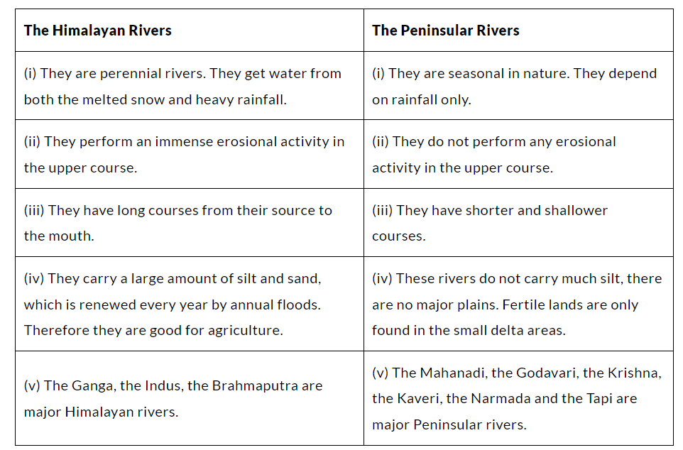
Q5. Compare the east-flowing and the west-flowing rivers of the Peninsular Plateau.
Ans: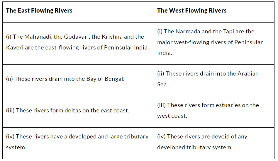
Q6. Why are rivers important for the country’s economy?
Ans:
Rivers play a vital role in a country's economy for several reasons:
- They are a key source of freshwater, essential for the survival of humans and wildlife.
- River water is used for domestic, industrial, and agricultural purposes.
- They facilitate trade and commerce by enabling the transport of goods.
- Rivers are potential sources of energy, particularly for hydroelectric power.
- They support navigation and transport, which are crucial for commercial activities.
- Rivers provide fishing opportunities and enhance scenic beauty, making them attractive for tourism.
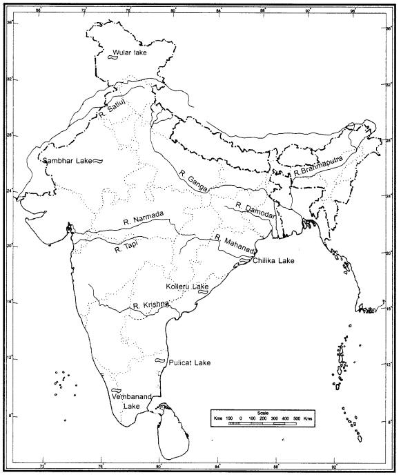
Q. (i) On the outline map of India mark and label the following rivers: Ganga, Satluj, Damodar, Krishna, Narmada, Tapi, Mahanadi, and the Brahmaputra.
(ii) On an outline map of India mark and label the following lakes: Chilika, Sambhar, Wular, Pulicat, Kolleru
Ans:
A water divide is an elevated area, like a mountain or upland, that separates two drainage basins. This means that water on either side flows into different rivers or lakes. For example, the water divide between the Indus and Ganga river systems is located at Ambala.
|
56 videos|439 docs|80 tests
|
FAQs on NCERT Solutions for Class 9 Geography Chapter 3 - Drainage
| 1. What is drainage in the context of geography? |  |
| 2. What are the different types of drainage systems? | |
| 3. How does drainage affect agriculture? | |
| 4. What is a watershed and its significance in drainage? | |
| 5. How do human activities impact drainage systems? | |


Important questions
,Free
,Summary
,MCQs
,ppt
,mock tests for examination
,Extra Questions
,NCERT Solutions for Class 9 Geography Chapter 3 - Drainage
,practice quizzes
,Semester Notes
,Viva Questions
,Previous Year Questions with Solutions
,past year papers
,NCERT Solutions for Class 9 Geography Chapter 3 - Drainage
,Objective type Questions
,shortcuts and tricks
,Exam
,NCERT Solutions for Class 9 Geography Chapter 3 - Drainage
,Sample Paper
,study material
,video lectures
;


NCERT Solutions: Drainage Free PDF Download
Importance of NCERT Solutions: Drainage
NCERT Solutions: Drainage Notes
NCERT Solutions: Drainage Class 9 Questions
Study NCERT Solutions: Drainage on the App
|
© EduRev
|
Education Revolution
|


|


within 7 days!