Drainage System

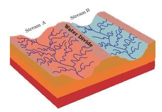
The term drainage describes the river system of an area. The area drained by a single river system is called a drainage basin. A closer observation on a map will indicate that any elevated area, such as a mountain or upland, separates two drainage basins. Such an upland is known as a water divide.
India's drainage systems are mainly controlled by the broad relief features of the subcontinent. Accordingly, the Indian rivers are divided into major groups:
- Apart from originating from the two major physiographic regions of India, the Himalayan and the Peninsular Rivers are different from each other in many ways. Most of the Himalayan Rivers are perennial.
- It means that they have water throughout the year. These rivers receive water from rain as well as from melted snow from the lofty mountains.
- The two major Himalayan Rivers, the Indus, and the Brahmaputra, originate from the north of the mountain ranges.
- They have cut through the mountains, making gorges. The Himalayan Rivers have long courses from their source to the sea.
- They perform an intensive erosional activity in their upper courses and carry huge loads of silt and sand.
- In the middle and lower courses, these rivers form meanders, oxbow lakes, and many other depositional features in their floodplains.
- They also have well-developed deltas. A large number of the Peninsular Rivers are seasonal, as their flow is dependent on rainfall. During the dry season, even the large rivers have reduced the flow of water in their channels.
- The Peninsular Rivers have shorter and shallower courses as compared to their Himalayan counterparts. However, some of them originate in the central highlands and flow towards the west. Most of the rivers of peninsular India originate in the Western Ghats and flow towards the Bay of Bengal.
Try yourself: Which of the following is incorrect about the Himalayan river system?
➢ Himalayan Drainage System

➢ Indus River System
- The Indus River is a great trans-Himalayan river in South Asia. It is one of the longest rivers in the world, with a length of some 1,800 miles (2,900 km).
- Its total drainage area is about 450,000 square miles (1,165,000 square km), of which 175,000 square miles (453,000 square km) lie in the Himalayan ranges and foothills, and the rest lie in the semiarid plains of Pakistan.
- The Indus originates in the Kailash range in Tibet near Lake Manasarovar. It follows a north-westerly course through Tibet. It enters Indian Territory in Jammu and Kashmir.
- Several tributaries - the Zaskar, the Shyok, the Nubra, and the Hunza join it in the Kashmir region.
- It flows through the regions of Ladakh, Baltistan, and Gilgit and runs between the Ladakh Range and the Zanskar Range.
- It crosses the Himalayas through a 5181 m deep gorge near Attock, lying north of the Nanga Parbat, and later takes a bend to the southwest before entering Pakistan.
- The main tributaries of the Indus in India are Jhelum, Chenab, Ravi, Beas, and Sutlej.
- Their flow varies greatly at different times of the year: the discharge is at a minimum during the winter months (December to February).
- There is a rise of water in spring and early summer (March to June), and foods occur in the rainy season (July to September). Occasionally, there are devastating flash floods.
➢ The Ganga River System

- The Ganga river system consists of the River Ganga and a large number of its tributaries. This system drains a very large area comprising the middle part of the Himalayas in the north, the northern part of the Indian Plateau in the south, and the Ganga Plain in between.
- The total area of the Ganga basin in India is 861,404 sq. km, which accounts for 26.3 per cent of the geographical area of the country. This basin is shared by ten states. These states are Uttaranchal and Uttar Pradesh (34.2%), Madhya Pradesh and Chhattisgarh (23.1%), Bihar and Jharkhand (16.7%), Rajasthan (13.0%), West Bengal (8.3%), Haryana (4.0%) and Himachal Pradesh (0.5%). The Union Territory of Delhi accounts for 0.2% of the total area of the Ganga Basin.
- The Ganga originates as Bhagirathi from the Gangotri glacier in Uttar Kashi District of Uttarakhand at an elevation of 7,010 m. Alakhnanda joins it at Devaprayag. But before Devaprayag, the Pindar, the Mandakini, the Dhauliganga and the Bishenganga rivers pour into the Alaknanda and the Bheling flows into the Bhagirathi.
- The total length of the Ganga River from its source to its mouth (measured along the Hugli) is 2525 km, of which 310 km in Uttaranchal, 1140 km in Uttar Pradesh, 445 km in Bihar and 520 km in West Bengal. The remaining 110 km stretch of the Ganga forms the boundary between Uttar Pradesh and Bihar.
- Before entering the Bay of Bengal, the Ganga, along with the Brahmaputra, forms the largest delta of the world between two arms: the Bhagirathi Hugli and the Padma/Meghna, covering an area of 58,752 sq km.
Try yourself: Which of the following is not a tributary of the river Indus?
- The delta front of the Ganga is a highly indented area of about 400 km in length extending from the mouth of the Hugli to the mouth of the Meghna. The delta is made of a web of distributaries and islands and is covered by dense forests called the Sunderbans.
- The important tributaries of Ganga are the Ramganga, the Gomati, the Ghaghara, the Gandak, and the Kosi. The river finally discharges itself into the Bay of Bengal near the Sagar Island.
- The Yamuna, the westernmost and the longest tributary of the Ganga has its source in the Yamunotri glacier on the western slopes of the Banderpunch range (6,316 km). It joins the Ganga at Prayag (Allahabad). It is joined by the Chambal, the Sind, the Betwa and the Ken on its right bank, which originates from the Peninsular plateau, while the Hindan, the Rind, the Sengar, the Varuna, etc. join it on its left bank.
- The Chambal rises near Mhow in the Malwa plateau of Madhya Pradesh and flows northwards through a gorge upwards of Kota in Rajasthan, where the Gandhisagar dam has been constructed. From Kota, it traverses down to Bundi, Sawai Madhopur, and Dholpur and finally joins the Yamuna. The Chambal is famous for its badlands topography called the Chambal ravines.
- The Gandak comprises two streams, namely Kaligandak and Trishulganga. It rises in the Nepal Himalayas between the Dhaulagiri and Mount Everest and drains the central part of Nepal. It enters the Ganga plain in Champaran district of Bihar and joins the Ganga at Sonpur near Patna.
- The Ghaghara originates in the glaciers of Mapchachungo. After collecting the waters of its tributaries - Tila, Seti and Beri, it comes out of the mountain, cutting a deep gorge at Shishapani. The river Sarda (Kali or Kali Ganga) joins it in the plain before it finally meets the Ganga at Chhapra.
- The Kosi is an antecedent river with its source to the north of Mount Everest in Tibet, where its mainstream Arun rises. After crossing the Central Himalayas in Nepal, it is joined by the Sun Kosi from the West and the TamurKosi from the East. It forms SaptKosi after uniting with the River Arun.
- The Ramganga is a comparatively small river rising in the Garhwal hills near Gairsain. It changes its course to the southwest direction after crossing the Shiwalik and enters into the plains of Uttar Pradesh near Najibabad. Finally, it joins the Ganga near Kannauj.
- The Damodar occupies the eastern margins of the Chotanagpur Plateau, where it flows through a rift valley and finally joins the Hugli.
- The Barakar is its main tributary. Once known as the 'sorrow of Bengal', the Damodar has been tamed by the Damodar Valley Corporation, a multipurpose project.
- The Sarda or Saryu River rises in the Milan glacier in the Nepal Himalayas, where it is known as the Goriganga. Along the Indo-Nepal border, it is called Kali or Chauk, where it joins the Ghaghara.
- The Mahananda is another important tributary of the Ganga rising in the Darjeeling hills. It joins the Ganga as its last left bank tributary in West Bengal.
- The Son is a major right-bank tributary of the Ganga River. It is a large south-bank tributary of the Ganga, originating in the Amarkantak plateau. After forming a series of waterfalls at the edge of the plateau, it reaches Arrah, west of Patna, to join the Ganga.
➢ Brahmaputra River System
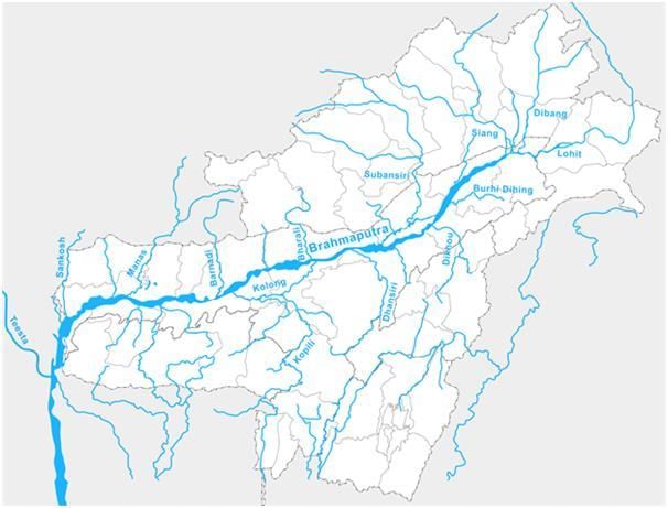
- The river Brahmaputra covers a catchment area of about 5,80,000 Sq.km. Right from its origin in Himalayan Lake Manasarover at an elevation of about 5,150 m in Tibet to its outfall in the Bay of Bengal.
- It flows eastward in Tibet and south, southwest in India and traverses a distance of about 2900 km, out of which 1,700 km is in Tibet, 900 km is in India and 300 km is in Bangladesh.
- In the upper reaches, the river is fed by the glaciers and in the lower reaches, it is joined by a number of tributaries, which originate at different elevations in the hills encircling the catchment, forming watersheds. Among the tributaries, Subansiri, Manas, Jiabharali, Pagladiya, Puthimari Sankosh, etc are snow-fed.
- The Tibetan name of the river is "TSANGPO," and the Chinese name is "YALUZANGBU". The watershed area is mostly on the northern side of the river in this region.
- After traversing a distance of about 1700 km eastward, the river changes its course from east to south and then enters Arunachal Pradesh in Indian Territory. Its name also changed from "TSANGPO" to Siang and Dehang in Arunachal Pradesh.
- The river then flows almost in the Southern direction for another distance of about 200 km up to Passighat. Before touching plains, it is joined by two major Himalayan tributaries viz. Lohit and Debang.
- The combined flow of these rivers is known as the Brahmaputra and passes through the plains of Assam and Bangladesh before falling into the Bay of Bengal. From Passighat to Dhubri, where it travels in the plains of Assam, it is well known as Brahmaputra Valley.
- The important tributaries of River Brahmaputra are:
(i) Left bank tributaries: Dhanasiri, Kapili, Barak.
(ii) Right bank tributaries: Subansiri, Jia Bhoraeli, Manas, Sankosh, Teesta & Raidak
(iii) Dhansiri: Rises from Naga Hills.
(iv) Sankosh: It's the main river of Bhutan, and it meets the Brahmaputra at Dhubri, Assam.
(v) Manas: Rises from Tibet and joins the Brahmaputra on its right bank.
(vi) Subansiri: It flows in between the Mikir hills & Abor hills and later joins the Brahmaputra on its right bank.
(vii) Tista: Rises from Kanchan-jungle, fed by tributaries like Rangit & Rangpo, it joins the Brahmaputra river in Bangladesh.
(viii) Barak: Rises in Nagaland. It enters Bangladesh as River Surma, which falls into River Padma at Chandpur.
Try yourself: Which of the following is a left bank tributary of the river Brahmaputra?
Drainage System of Peninsular India
➢ Origin of Peninsular Drainage
- Subsidence of the western flank of the peninsula during the early tertiary period. It has disturbed the symmetry of the peninsular block's river watershed.
- The upheaval of the Himalayas when the northern flank of the peninsular block was subjected to subsidence and consequent trough faulting. The Narmada and Tapi flow in trough faults and fill the original cracks with detritus materials. Hence, there is a lack of alluvial and deltaic deposits in these rivers.
- Slight tilting of the peninsular block from North-West to South-East has caused an entire drainage system to flow towards the Bay of Bengal.
- Types of Peninsular River System (On the basis of the direction of flow)
(i) West-flowing rivers
(ii) East flowing rivers
➢ West-flowing rivers
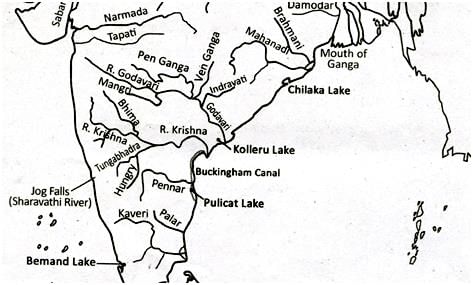
➢ Narmada
- Origin - Amarkantak plateau (1,057m) (Shahdol district, Madhya Pradesh)
- Total Length - 1,310 km (largest west flowing river) Only 112 km navigable from the mouth.
(i) Flows 1,078 km in Madhya Pradesh form a 32 km long boundary between M.P. and Maharashtra.
(ii) Forms 40 km long boundary between Maharashtra & Gujarat Flows 160 km in Gujarat
(iii) Makes an estuary before entering into the Gulf of Khambhat.
(iv) There are several islands in the estuary formed by Narmada. Alphabet is an important estuary island. - States - M.P., Maharashtra, Gujarat
- Landmarks - Dhuan Dhar Falls, also called a cloud of mist (30m), is located in Jabalpur district, Madhya Pradesh. This fall is located in a Gorge of marble.
- Other falls- Mandhar falls (12m)Dardi fall (12m) Sahasradhara falls (8m)
➢ The Tapi (or Tapti)

- Origin - Betul plateau (M.P) in Satpura Range
- Total length - 730 km (32 km from the sea)
- State - M.P, Maharashtra& Gujarat
- Meets - Arabian Sea at Gulf of Khambhat
➢ The Sabarmati
- Sabarmati River is formed by the confluence of Sabar and Hathmati streams
- Origin - Mewar hills (Aravalli range) (Rajasthan)
- Length - 320 km
- Mouth - Gulf of Khambhat
- States - Rajasthan & Gujarat
- Tributaries - The Sedhi, The Harnav, the Vartak, the Wakul, The Mesh
➢ The Mahi

- Origin - Vindhyas (500 m)
- Meeting point - Gulf of Khambat
- States - Madhya Pradesh, Maharashtra& Gujrat
- Length - 533 km
- Tributaries - Som, Anas and Panam
➢ Luni
- Also known as 'Sabarmati'
- It flows through 'Thar Desert'
- It has an Inland Drainage as it disappears into Marshy land of Rann of Kutch
- Origin - Aravalli (west of Ajmer, Rajasthan)
- Length - 482 km
- Meeting point - Lost in Marshy land of Rann of Kutch (Inland drainage)
Try yourself: Which of the following river is the longest west flowing river?
➢ Damodar
- Origin - Chotanagpur plateau
- Length - 541 km
- It joins the Bhagirathi-Hooghly in West Bengal
- Also known as 'Sorrow of Bengal.'
➢ Suvarnrekha
- Origin - Ranchi plateau
- Length - 474 km
- Tributaries - Baitarni & Brahmani
- It flows in the States of Jharkhand and Orissa
➢ Mahanadi
- Origin - Dandakaranya (near Sihawa, Raipur, Chhattisgarh)
- Length - 857 km States -
- It flows in Chhattisgarh and Odisha.
- It forms a delta of about 9,500 km sq.
➢ Rushikulya River
- Origin - Nayagarh hills (Odhisha)
- Length - 165 km
- States - Its flows in Odisha
- It flows near Chilka Lake (the largest brackish water lake in Asia)
- The mouth of Rushikulya River is known for the mass hatching of olive ridley turtles. This is the smallest and most abundant of all sea turtles found in the world.
- Olive Ridley turtles are only found in tropical waters of the Pacific, Atlantic and Indian Oceans.
➢ Godavari River

- Origin - Trimbak plateau (Nashik, Maharashtra)
- Length - 1,465 km States - Maharashtra, Andhra Pradesh, Telangana
- It is the second-largest river in India and the largest river system in Peninsular India
- It is also called Gautami or Virdhha Ganga.
- The total catchment area is 312,812 sq. km.
- Important tributaries are Wardha, Penganga, Weinganga, Sabri, Indravati and Manjara
- Below Rajamundry, the river divides into two main streams, the Gautami Godavari on the east and the Vashishta Godavari on the west, forming a large delta.
➢ Krishna River

- Origin - the Western Ghats just north of Mahabaleshwar (Maharashtra)
- Length - 1400 km
- State - Maharashtra, Telangana, Karnataka, Andhra Pradesh
- Important tributaries are Tungabhadra, Koyna, Bhima, Mallapraba, Ghatprabha, Musi, Manjeera and Dhudganga.
- It debouches into the Bay of Bengal, forming a big delta in an arcuate shape.
➢ Pennar
- Origin - Nandidurg Peak (Karnataka)
- Length - 597 km
- State - Karnataka and Andhra Pradesh
- Tributaries - Kundur, Charavati, Papagni, Punchu
➢ Kaveri
- Origin - Taal Kaveri (Bramhagiri Range, Coorg, Karnataka)
- Length - 800 km
- States - Karnataka, Tamil Nadu
- It receives rainfall from both southwest monsoons as well as retreating northeast monsoons due to which it causes food in its lower course during winter.
- One of the most well-utilized rivers having a 90-95% capacity utilized.
- Forms delta before merging into the Bay of Bengal.
- Sivasamudram waterfalls (101 m high) are situated on it.
- It Is also called The Ganga of the south
➢ Vaigai River
- Origin - Varushand hills (near Annamalai hills & Palani hills)
- Length - 258 km
- State - Tamil Nadu
- It is a dry channel that reappears and disappears frequently.
- Madurai is located on the Vaigai river

FAQs on Drainage System
| 1. What are the main types of drainage patterns in India and how do they differ? |  |
| 2. How do exogenous and endogenous rivers differ in the Indian drainage system? | |
| 3. What's the difference between consequent and subsequent rivers in a drainage basin? | |
| 4. Why do some Indian rivers flow eastward while others flow westward, and what determines drainage direction? | |
| 5. How can I identify and differentiate river capture and stream piracy in the Indian drainage system? | |


