Highway Development & Planning | Civil Engineering SSC JE (Technical) - Civil Engineering (CE) PDF Download

Highway Development & Planning
Order of Road Development:
1. Roman Roads:
• Roman started Ist time construction of roads in large scale. In 312B.C. they constructed Appian way of length over 580 km.
Main features of Roman roads are:
1. They were straight regardless of gradients.
2. Total thickness was as high as 0.75 to 1.2 meters.
3. The wearing course consists of dressed large stone-blocks set in lime mortar.
Do you know ?
They were built after the soft soil was removed and hard stratum was reached.
2. Tresaguet Construction (1716 - 1796):
• “Pierre tresaguet” development roads in France during 1764 A.D.
Do you know ?
The main feature of Pierre Tresaguet proposal was that the thickness of construction needed was of the order of 30 cm.
Main Features are:
1. Thickness was of the order of 30 cm.
2. Consideration was given to subgrade moisture and drainage of surface water.
3. The top wearing surface was made up of smaller slope having a cross slope of 1 in 45 to the surface to provide surface drainage. Shoulder sloping was also provided of the order of 1 in 20.
3. Metcalf. Construction (1717-1810):
• “John Metcalf” was working in England and he followed the instruction of Robert Phillip.
4. Telford Construction (1757-1834):
• His work started in early 19th century in England.
Main Features are:
1. He provided level subgrade of width 9 meters.
2. A binding layer of wearing course 4 cm thick was provided with cross slope of 1 in 45.
3. Thickness of foundation stone varied from 17 cm at edge to 22 cm at the centre.
5. Macadam Construction (1756-1836):
• He put forward an entirely new method of road construction as compared to all the previous methods.
• The first attempt to improve the road condition was made by him in 1815. This was the Ist method based on scientific thinking.
Main Features are:
1. Macadam was the first person who suggested that heavy foundation stones are not at all required to be placed at the bottom layer. He provided stones of size less than 5 mm to a uniform thickness of 10 cm.
2. The importance to subgrade drainage and compaction was given so the subgrade was compacted and prepared with cross slope of 1 in 36.
3. The size of broken stone for the top layers was decided on the basis of stability under animal drawn vehicles.
4. The pavement surface was also given the cross slope of 1 in 36.
5. Total thickness was kept uniform from edge to centre to a minimum value of 25 cm.
6. Water Bound Macadam (W. B. M):
• In this method the broken stones of the base course and surface course are bound by the stone dust in the presence of moisture.
Modern Road Developments in India:
• British government passed a resolution in 1927, in response to which Jayakar Committee was constitution in 1927.
• Jayakar committee proposed that an extra tax should be levied on petrol to develop a fund called “Central Road Fund”.
Recommendations made by Jayakar Committee are:
1. The road development in the country should be considered as a national interest as this has become beyond the capacity of provincial governments and local bodies.
2. An extra tax should be levied on petrol from the road users to develop a road development fund called Central Road Fund.
3. A semi official technical body should be formed to pool technical know how from various parts of the country and to act as an advisory body on various aspects of roads.
4. A research organization should be instituted to carry out research and development work and to be available for consultations.
• Most of the recommendations made by Jayakar committee were accepted and following steps were taken.
1. The Central Road Fund was formed in 1st March 1929.
2. A semi official technical body known as Indian Roads Congress (IRC) was formed is in 1934.
3. In 1939 Motor Vehicle Act was started & in 1950 CRRI (Central Road Research Institute) was started. Motor vehicle act has been revised in the year 1988.
Other Measures Taken are:
4. National Highway Act was brought in 1956.
5. Highway Research Board was setup in 1973, with view to given proper direction and guidance to road research activities in India.
6. National Transport Policy committee in 1978.
7. IRC has played important role in the formulation of the last three 20 years road development plan in India.
1. First 20 years Road Plan (Nagpur Road Plan) (1943-63):
• A conference of the Chief Engineers of all the states and provinces was convened in 1943 by the Government of India at Nagpur, an initiative of the Indian Roads Congress to finalise the first road development plan for the country as a whole.
• In this first 20 years road development plan, popularly known as the Nagpur Road Plan, all roads were classified into five categories and a twenty year development programme for the period 1943-63 was finalized.
Features :
1. The Nagpur road plan formulas were prepared on the based of “star and grid” pattern.
2. The total road length of 5,32,700 km with a density of 16 km of road length per 100 km2 area would be available by 1963.
3. All the road were classified into 5 categories.
(i) NH
(ii) SH
(iii) MDR
(iv) ODR
(v) VR
4. The length of the railway tracks in the areas was considered within the road length.
Hence net road length is calculated by subtracting length of railway track from the length of metalled road.
| Sl. No | Category of road | Nagpur Plant targets, km | Achievement by 1961 km |
National Highway | 26,715
|  | |
| State Highway | 86,825 | 62,052 | |
| Major District Roads | 80,145 | 1,13,483 | |
| Total main roads (metalled roads) | 2,00,365 | 1,98,171 | |
| Other District Roads | 1,33,580 | 1,11,961 | |
| Village Roads | 1,98,755 | 3,88,841 | |
| Unclassified Roads | — | 10,49 | |
| Total | 5,32,700 | 7,09,122 |

• The total length of the first category or metalled roads for National and State Highways and Major District roads in km is given by the formula NH + SH + MDR (km)
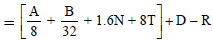
Where, A = Agricultural area, km2
B = Non-agricultural area, km2
N = Number of towns and villages with population range 2001-5000
T = Number of town and villages with population over 5000
D = Development allowance of 15 percent of road length calculated to be provided for agricultural and Industrial development during the next 20 years.
R = Existing length of railway track in km.
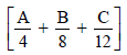
• The total length of second category road for Other District Road and village Roads in km is given by the formula ODR + VR (km) = [0.32 V + 0.8Q + 1.6P + 3.2S] + D
Where, V = Number of villages with population 500 or less Q = Number of villages with population range 501-1000
P = Number of villages with population range 1001-2000,
S = Number of villages with population range 2001-5000,
D = Development allowance of 15% for next 20 years.
Do you know ?
Though the total achievement was higher than the targeted value, but the lengths of NH and SH achieved were lesser than the plan targets.
Central Road Research Institute:
• In the year 1950 the Central Road Research Institute (CRR) was started at New Delhi for research in various aspect of highway engineering.
• The CRR is one of the national laboratories of the Council of Scientific Industrial Research the institute is mainly engaged in applied research and offers technical advice the state governments concerning roads.
National Highway Act In 1956 the National Highway Act was passed.
The main features of the act are:
(i) The responsibility of development and maintenance of the National Highway (NH) to be provisionally taken by the central government.
(ii) The central government to be empowered to declare any other highway as NH or to omit any of the existing national highway from the lists.
2. Second 20 years Road Plan (Bombay Road Plan)-(1961-1981) Features:
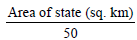
1. At the end of plan, the target road length aimed was 32 km per 100 square km area.
2. Maximum distance of any place in a developed or agricultural area would be 6.4 km from a metalled road and 2.4 km from any category of roads.
3. Every town with a population above 2000 in plains and above 1000 in semi-hill areas and above 500 in hilly areas should be connected by metalled road.
4. 1 6 00 km Express ways have be en considered in this plan within proposed target of NH.
5. Length of railway track is considered independent of the road system and hence it is not subtracted to get the road length.
6. A development factor 5% is provided for future developments.
7. Expressway is added.
Result:
• The total achievement was higher than targeted bu NH and SH were constructed lesser than targeted.
• It should be noted that allowance for development of agriculture and industry during the next 20 years was made in Nagpur plan allowing 15% increase in the calculated road length. This allowance according to the second plan is 5% only.
(i) National Highways (km)
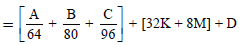
(ii) National Highways + State Highways (km)
(iii) National Highways + State Highways + Major District Roads (km)
(iv) National Highway + State Highway + Major District Roads + Other District Roads (km)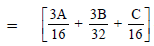
[ 48 K + 24M + 11.2N + 9.6P + 6.4Q + 2.4R] + D
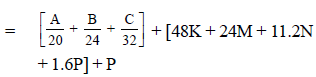
(v) National Highways + State Highways + Major District Roads + Other District Roads + Village Roads i.e., all roads (km)
[48K + 24M + 11.2N + 9.6P + 12.8Q + 5.9R + 1.6S + 0.64T + 0.2V] + D
Where, A = Development and agricultural areas; km2 B = Semi-developed area, km2 C = Undeveloped area, km2
K = Number of town with population over 1,00,000
M = Number of towns with population range 1,00,000-50,000
N = Number of town with population range 50,000-20,000
P = Number of towns with population range 20,000-10,000
Q = Number of towns with population range 10,000-5,000
R = Number of towns with population range 5,000-2,000
S = Number of town with population range 2,000- 1,000
T = Number of towns with population range 1,000-500
V = Number of towns with range below 500
D = Development allowance of 5 percent of road length calculated for further development and other unforeseen factors.
3. Third 20 years Road Plan (Lucknow Road Plan)-(1981-2001) Features:
1. Roads are classified into primary, secondary and tertiary road systems.
2. All villages with over 500 population (Based on 1981 census) should be connected by all weather roads.
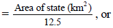
3. The overall road density was targeted as 82 km per 100 square km area.
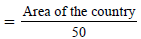
4. The NH network should be expanded to form square grids of 100 km sides so that no part of the country is more than 50 km away from a NH.
6. There should be improvement in environmental quality and road safety:
A. Primary Road System: (According to third plan) This includes
(a) Express ways of total length 2000 km.
(b) NH based on the concept of 100 km square grids. 100 + 100 = 200 Km of NH length are provided per 100 × 100 = 10000 square km area. This means 1 km per 50 square km area.
Total length of NH (according to this concept), in the country

≈ 66000 km
B. Secondary Road System: This includes
1. SH 2. MDR (Major District Road)
1. (a) Length of SH in km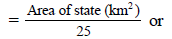
(b) Length of SH in km = 62.5 × no. of towns in state – Length of NH = 62.5 × No. of towns in state –
2. (a) Length of MDR in km
(b) Length of MDR in km = 90 × No. of towns in state.
C. Tertiary Road System : This includes
1. ODR (other district roads) and
2. VR (Village Roads)
Classification of Roads:
A. Classification of Rural Roads The roads are classified on the following basis
(a) Traffic volume – Heavy, Medium or Light.
(b) Load Transport – Class-A, Class B etc.,
(c) Location and function.
• Nagpur Road plan classified roads into following 5 categories based on location nad function.
1. NH
2. SH
3. MDR
4. ODR
5. VR
• Modified classification is proposed by third plan as discussed.
B. Classification of Urban Roads: The length of the urban roads are not included in the target of third twenty year plan (1981-2001) The urban roads are classified as
1. Arterial roads
2. Sub arterial roads
3. Collector streets
4. Local streets
Road Patterns:
(a) Rectangular or block pattern - Adopted in Chandigarh
(b) Radial or star and block pattern
(c) Radial or star and circular pattern - Adopted at Connaught place of Delhi.
(d) Radial or star and grid - Adopted in Nagpur road plan.
(e) Hexagonal pattern
(f) Minimum travel pattern
Planning Surveys:
For assessing the road length requirements, following studies are made.
1. Economic studies.
2. Financial studies - (sources of income)
3. Traffic or road use studies.
4. Engineering studies.
Saturation system for calculating optimum road length:
• In this system the option road length is calculated for area, based on the concept of obtaining maximum utility per unit length of road, Hence this system is called saturation system of maximum utility system.
Factors for obtaining the utility per length of road are:
1. Population served by the road.
2. Productivity served by the road network
(a) Agricultural product.
(b) Industrial products.
(a) Village having population range between 1001 and 2000 may be grouped together and be assigned one utility unit per village.
(b) For population less than 500, utility unit = 0.25
(c) For population less than 501 to 1000, utility unit = 0.50
(d) For population 1001 to 2000, utility unit = 1.00
(e) For population 2001 to 5000, utility unit = 2.00
• After deciding the optimum road length for plan period. The final step is the phasing of the road development plan by fixing up the priorities for the construction of different road links.
Engineering Surveys for Highway Location:
• Before highway alignment is finalized in highway project, the engineering surveys are to be carried out.
The stages of engineering surveys are:
(a) Map Study: Topographic maps are available from the Survey of India with 15 to 30 meter contour intervals. Valley, ponds or lakes etc. can be avoided and approximate position of bridges etc. can be planned.
(b) Reconnaissance: This is used to examine the general characteristics of the area for deciding the most feasible routes for detailed studies.
(c) Preliminary survey: This is carried out to collect all the physical information which are necessary in connection with the proposed highway alignment. This work consist of
1. Primary traverse
2. Topographical features
3. Leveling work
4. Drainage studies & hydrological data.
5. Soil survey
6. Material survey
7. Determinations of final centre line
8. Traffic Survey
(d) Final location and detailed survey: The centre line of road finalized is translated on the ground during location survey.
Detailed survey is done to fix temporary bench mark and leveling work is used for drainage and earthwork calculations.
|
2 videos|133 docs|55 tests
|
FAQs on Highway Development & Planning - Civil Engineering SSC JE (Technical) - Civil Engineering (CE)
| 1. What is highway development and planning? |  |
| 2. What are the benefits of highway development and planning? | |
| 3. What are some of the challenges associated with highway development and planning? | |
| 4. What are some of the key considerations when planning a new highway project? | |
| 5. How are highway development and planning decisions made? | |


Objective type Questions
,Semester Notes
,Free
,MCQs
,shortcuts and tricks
,Exam
,Summary
,past year papers
,Important questions
,video lectures
,study material
,Highway Development & Planning | Civil Engineering SSC JE (Technical) - Civil Engineering (CE)
,Previous Year Questions with Solutions
,mock tests for examination
,Viva Questions
,Sample Paper
,Highway Development & Planning | Civil Engineering SSC JE (Technical) - Civil Engineering (CE)
,Extra Questions
,ppt
,Highway Development & Planning | Civil Engineering SSC JE (Technical) - Civil Engineering (CE)
,practice quizzes
;


Highway Development & Planning Free PDF Download
Importance of Highway Development & Planning
Highway Development & Planning Notes
Highway Development & Planning Civil Engineering (CE) Questions
Study Highway Development & Planning on the App
|
© EduRev
|
Education Revolution
|


|


within 7 days!