Important Points & Differences: Climate

Important Points To Remember
1. Mango showers
These are pre-monsoon showers that occur along the south-western coast of India just before the onset of the main monsoon season. They are locally important for horticulture, especially for the ripening of mangoes.
- Occur in the pre-monsoon months over Kerala and coastal Karnataka.
- Help in the early ripening of mangoes and improve their quality by reducing heat stress.
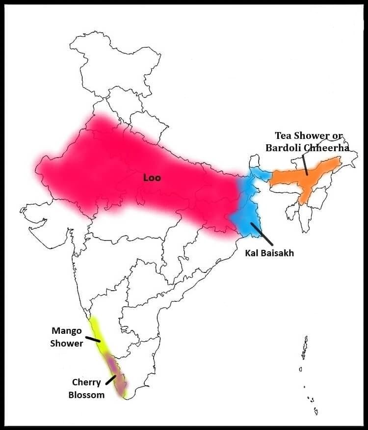 Regions of Mango Shower and Kal Baisakh
2. Kalbaisakhi
Kalbaisakhi is a local severe weather phenomenon in eastern India associated with the onset of summer.
- The term literally refers to violent black clouds appearing around the month of Baisakh (April-May).
- Associated with strong north-westerly and northerly winds in parts of Bengal and Assam.
- Often causes sudden heavy rainfall, gusty winds and sometimes destruction to standing crops and structures.
3. Why Chennai receives more rain in winter
Chennai receives appreciable rainfall during the winter months because of seasonal onshore winds from the Bay of Bengal.
- Northeast winds during winter pick up moisture from the Bay of Bengal and bring rainfall to the Tamil Nadu coast.
- These are examples of onshore winds that cause rainfall along the east coast in winter.
- In summer:
- Chennai lies in the rain-shadow of the Western Ghats for the Arabian Sea branch of the south-west monsoon.
- Winds tend to be offshore in summer, resulting in less rainfall along the city's coast.
4. Break of the monsoon
Refers to a temporary dry spell during the monsoon season.
The monsoon rains stop for a few days or even weeks.
Rainfall becomes confined mainly to the foothills of the Himalayas and the northeast.
Causes dry conditions over other parts of India.
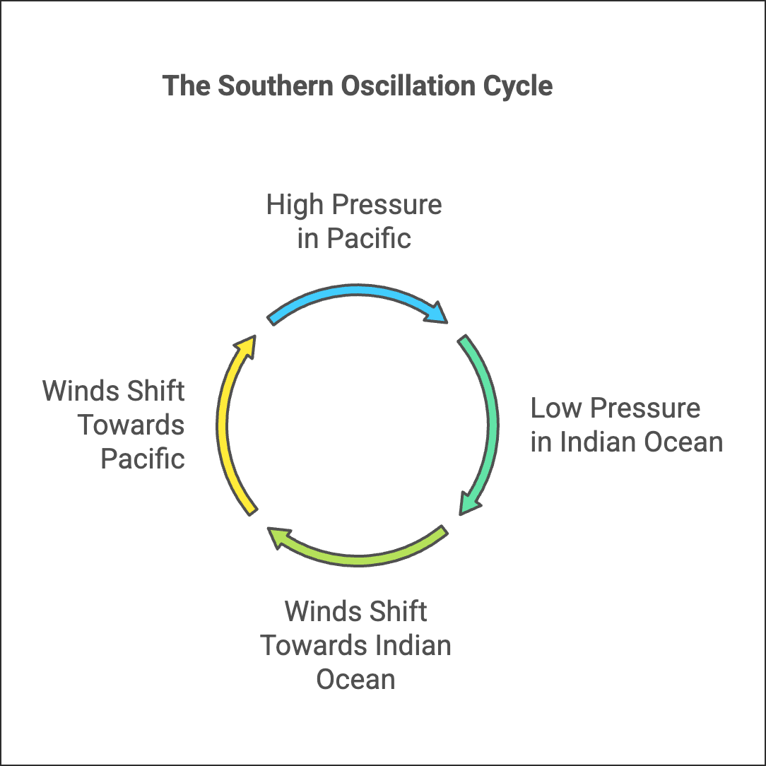
5. Southern Oscillation
The Southern Oscillation is the large-scale seesaw in atmospheric pressure between the tropical Pacific and the tropical Indian Ocean and is important for global weather patterns.
- It describes the interrelation between pressure systems over the Pacific and the Indian Ocean.
- When pressure is relatively high in the Pacific, it tends to be low in the Indian Ocean, and vice versa.
- Seasonal shifts of winds across the equator are connected with the Southern Oscillation and influence monsoon strength and distribution.
6. Mawsynram - the highest rainfall in the world
Mawsynram in the Khasi Hills is renowned for extreme annual rainfall because of its unique topography and prevailing wind directions.
- It lies at the head of a funnel-shaped valley in the Khasi Hills, which concentrates moisture-laden winds.
- Uplift of these oncoming winds over the hills causes intense condensation and very high rainfall, making Mawsynram one of the wettest places on Earth.
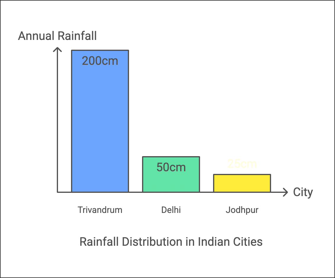
7. Why overall rainfall decreases from south to north in India
General pattern of decreasing rainfall from the southern tip towards northern inland regions is controlled by the origin and paths of the south-west monsoon branches and the shape of the Indian peninsula.
- The south-west monsoon originates over the Indian Ocean and splits into branches because of the shape of the Indian peninsula.
- Trivandrum (southern tip) receives more than 200 cm of annual rainfall in many years because of the direct onshore impact of the Arabian Sea branch.
- Delhi, being far inland, receives only about 50 cm of rainfall on average.
- The Arabian Sea branch:
- Hits the Western Ghats and causes very heavy rainfall on the windward side.
- Flows northwards and then inland where, in regions such as Jodhpur, it travels parallel to the Aravallis and results in low rainfall (less than 25 cm).
8. Why the Western Ghats receive more rain than the Eastern Ghats
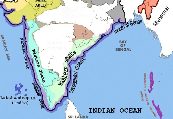 Map showing the position of Western and Eastern Ghats
- The Arabian Sea branch of the south-west monsoon reaches the Western Ghats as onshore winds, which are forced to rise over the western slopes.
- Rising air cools and condenses, producing heavy rainfall on the windward side of the Western Ghats.
- By the time these winds cross the Ghats and reach the east coast, much of their moisture has been lost, so the Eastern Ghats receive less rain.
- Parts of the east coast are affected by offshore winds during parts of the season and therefore get less orographic rainfall.
- The Eastern Ghats largely lie in the leeward (rain-shadow) area for the Arabian Sea branch and thus record lower rainfall.
Would India have been arid without the monsoons?
- About 75 to 90% of India's annual rainfall is received from the monsoon system, so monsoons are the principal source of water for agriculture and rivers.
- These winds arise because of the uneven heating of land and sea between the Asian landmass and surrounding oceans.
- The Himalayas and other mountain systems modify the paths of the two main branches of the south-west monsoon (the Arabian Sea and the Bay of Bengal branches) and help distribute rainfall across the subcontinent.
- Without the monsoons India's climate would be much drier and large regions could have resembled arid zones.
Try yourself: What is the primary factor responsible for the formation of monsoon winds in India?
Important Differences Between:
1. Equable Climate & Extreme Climate
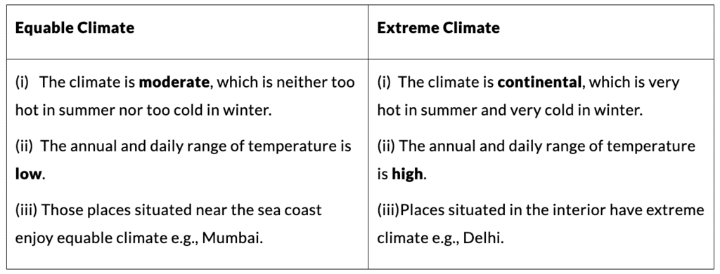
These terms describe the annual range and variability of temperature and, to some extent, precipitation at a place.
- Equable climate:
- Has a small annual range of temperature-winters are mild and summers are not very hot.
- Usually found in coastal regions and areas with strong maritime influence.
- Daily and seasonal changes are moderate and predictable.
- Extreme climate:
- Shows a large annual range of temperature-very cold winters and very hot summers.
- Typical of continental interiors far from the moderating influence of oceans.
- Weather conditions can be harsh and variable.
2. Rainfall and Precipitation
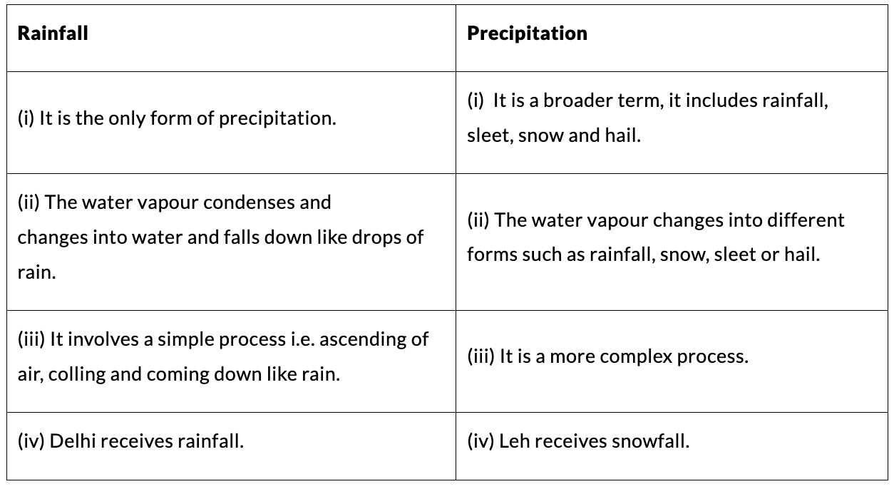
These two words are related but have distinct meanings in meteorology.
- Precipitation is the general term for any form of water-liquid or solid-falling from the atmosphere to the ground, including rain, snow, sleet and hail.
- Rainfall specifically refers to the amount of liquid precipitation that falls as rain; it is commonly measured in millimetres.
- In climate and hydrology discussions, precipitation may be used when all forms of moisture input are considered; rainfall is used when only liquid rain is relevant.
3. South-West Monsoons and Retreating Monsoons
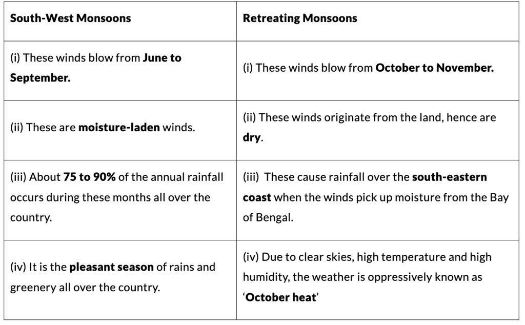
These two phases refer to different seasonal movements of wind and associated rainfall in the Indian region.
- South-West monsoon (advancing monsoon):
- Occurs mainly from June to September.
- Winds blow from the Indian Ocean towards the Indian subcontinent bringing the majority of annual rainfall to most parts of India.
- Controls the main agricultural season (kharif).
- Retreating monsoon (also called the north-east monsoon in some contexts):
- Occurs during October to December as the south-west monsoon withdraws and winds reverse.
- Brings important rainfall to parts of the south-east coast of India (Tamil Nadu and adjoining areas), known as the north-east monsoon rainfall.
4. Loo and Cold Wave
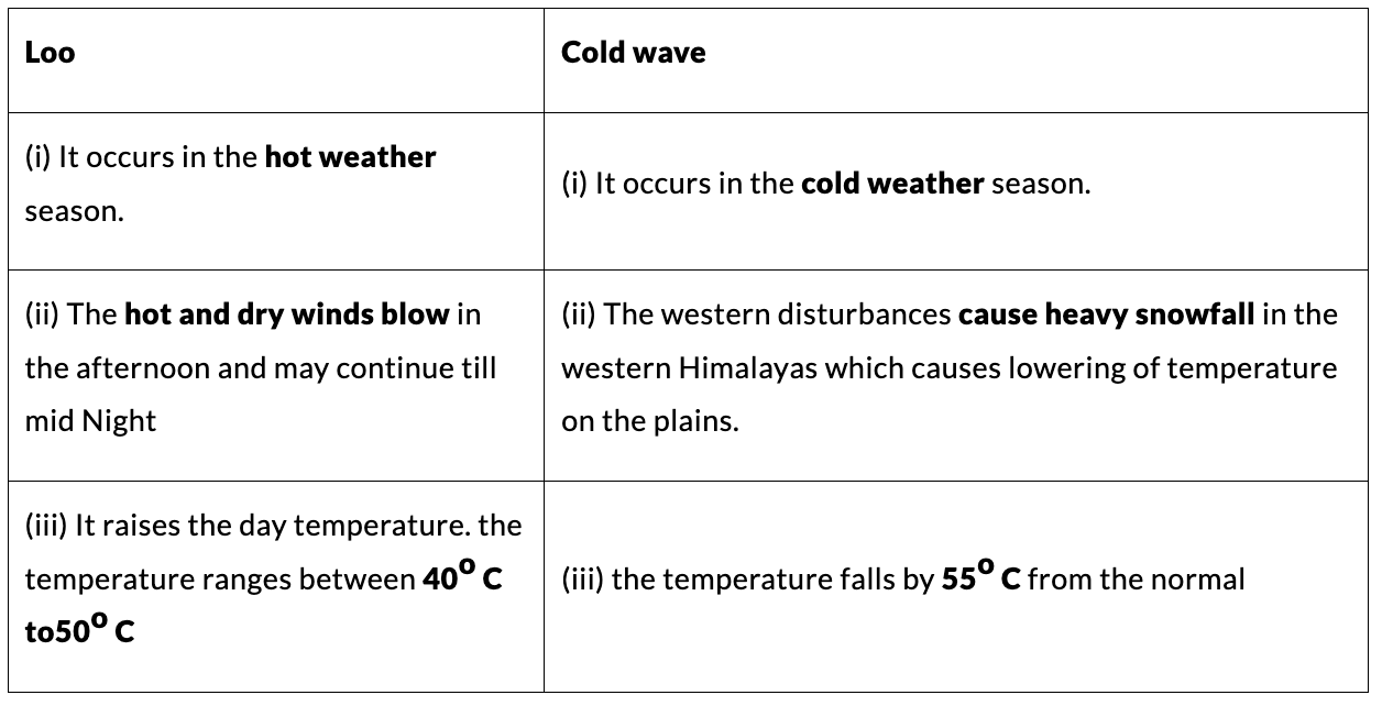
These are contrasting weather phenomena associated with extreme heat and extreme cold respectively.
- Loo:
- A strong, hot, dry wind that blows over the north Indian plains during the peak summer months (mainly May and June).
- Raises daytime temperatures sharply and can cause heat stroke and dehydration.
- Cold wave:
- A rapid fall in temperature often caused by the movement of cold air masses from higher latitudes or from the Himalayas.
- Results in unusually cold conditions, frost in some regions, and increased demand for heating.
5. South-West Monsoons and North-East Monsoons
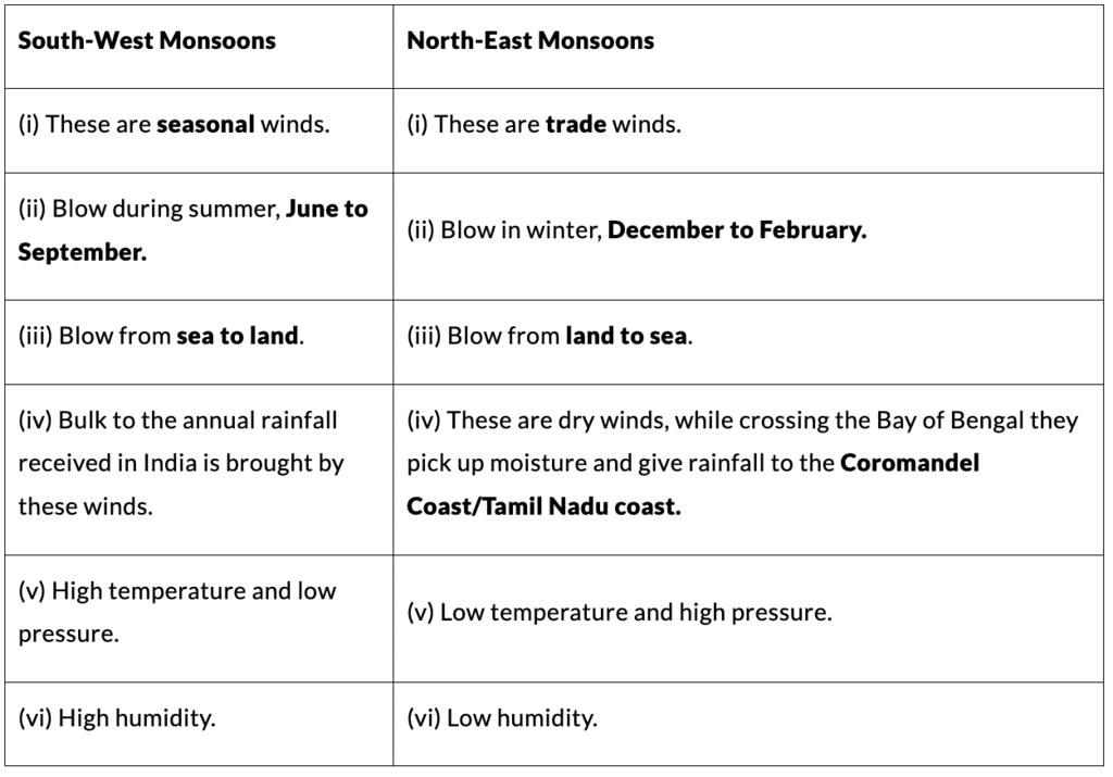
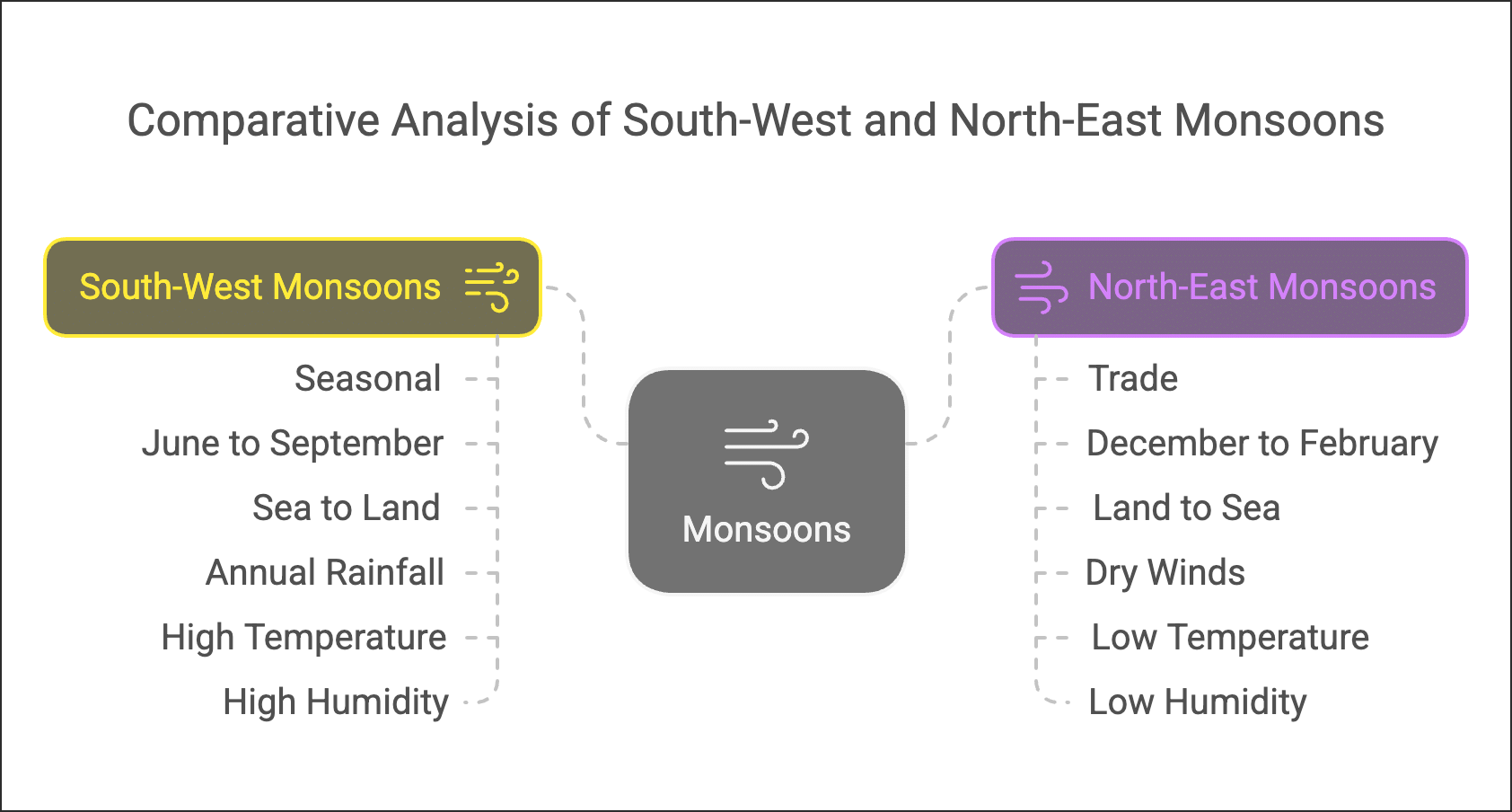
These two monsoon systems differ in direction, season and the areas they affect.
- South-West monsoon:
- Blows from the south-west (from the Indian Ocean) to India during June-September.
- Brings the bulk of India's rainfall, particularly to the west coast, central India and the north-east.
- North-East monsoon:
- Occurs when winds blow from the north-east during October-December as the monsoon withdraws.
- Provides significant rainfall to the southeastern coast of India (Tamil Nadu and parts of Andhra Pradesh), often called the retreating monsoon rainfall.
- Direction, timing, area affected and intensity of rainfall differ between the two systems, and both are important for different cropping seasons and water resources.
Try yourself: Which of the following is a significant difference between South West Monsoons and Retreating Monsoons?
FAQs on Important Points & Differences: Climate
| 1. What's the difference between weather and climate for Class 9 SST exams? |  |
| 2. How do latitude and altitude affect climate differently? | |
| 3. What are the main climate types in India and how do they differ? | |
| 4. Why do coastal areas have different climates than inland regions? | |
| 5. What role do ocean currents and winds play in determining regional climate? | |


