UPSC Exam  >  UPSC Test  >  Geography CSE  >  Test: Landforms And Their Evolution - UPSC MCQ

Landforms And Their Evolution - UPSC Geography Free MCQ Test with solutions


MCQ Practice Test & Solutions: Test: Landforms And Their Evolution (15 Questions)

You can prepare effectively for UPSC Geography for UPSC CSE with this dedicated MCQ Practice Test (available with solutions) on the important topic of "Test: Landforms And Their Evolution". These 15 questions have been designed by the experts with the latest curriculum of UPSC 2026, to help you master the concept.

Test Highlights:

  • - Format: Multiple Choice Questions (MCQ)
  • - Duration: 10 minutes
  • - Number of Questions: 15

Sign up on EduRev for free to attempt this test and track your preparation progress.

Test: Landforms And Their Evolution - Question 1

i. Limestone Pavement: A flat, exposed area of limestone characterized by blocks called clints and fissures called grikes.

ii. Karst Topography: A landscape formed from the dissolution of soluble rocks including limestone and dolomite.

iii. Alluvial Fan: A fan-shaped deposit formed when a stream's velocity decreases as it exits a mountain range onto a flat plain.

iv. Pothole: A circular hole in a rock bed formed by the swirling action of water and sediment.

Which of the statements is/are true?

Detailed Solution: Question 1

  • Statement i: Correct. Limestone pavement consists of blocks (clints) and fissures (grikes) formed by erosion.
  • Statement ii: Correct. Karst topography is characterized by features like sinkholes and caves, formed by the dissolution of soluble rocks.
  • Statement iii: Correct. An alluvial fan is formed when a stream's velocity decreases, depositing sediments in a fan shape.
  • Statement iv: Correct. Potholes are circular depressions in rock beds formed by the swirling action of water and sediment.

Test: Landforms And Their Evolution - Question 2

Assertion (A)- Valleys start as small and narrow rills; the rills will gradually develop into long and wide gullies; the gullies will further deepen, widen, and lengthen to give rise to valleys.
Reason (R)- In streams that flow rapidly over steep gradients, normally erosion is concentrated on the bottom of the stream channel

Detailed Solution: Question 2

  • Assertion correctly describes the process of valley formation through the progression from small rills to wide valleys.
  • Reason is also accurately highlights the pattern of erosion in streams with steep gradients, emphasizing erosion concentration at the channel bottom. However, Reason does not directly explain the Assertion. 

Test: Landforms And Their Evolution - Question 3

Which coastal feature is formed as a ridge of sand and shingle lying approximately parallel to the coast and typically exposed during low tide?

Detailed Solution: Question 3

  • A barrier bar is a ridge of sand and shingle that forms parallel to the coastline.
  • Typically, these formations become exposed during low tide.
  • Barrier bars often occur at river mouths or bay entrances.
  • They act as natural barriers that can protect coastal areas from wave action.
  • Barrier bars play a crucial role in coastal dynamics.
  • They help to create lagoons and significantly influence sediment deposition patterns.
  • Interestingly, barrier bars serve as vital buffers against storm surges.
  • They absorb much of the wave energy during extreme weather events.

Test: Landforms And Their Evolution - Question 4

Which of the following stages do landforms undergo as they evolve over time?

Detailed Solution: Question 4

  • Landforms progress through three distinct stages: youth, mature, and old.
  • In the youth stage, landforms are typically characterized by sharp features and steep gradients.
  • In the mature stage, they often have more rounded features due to erosion.
  • In the old stage, landforms may appear flat and exhibit minimal change.
  • This classification helps geologists and geomorphologists understand the lifecycle of various landforms and the processes that shape them.

Test: Landforms And Their Evolution - Question 5

Which of the following best describes incised or entrenched meanders?

Detailed Solution: Question 5

  • Incised or entrenched meanders are formed as streams cut deeply into their valleys.
  • They often develop over original gentle surfaces.
  • This process can lead to the formation of deep gorges and canyons.
  • This is particularly notable in hard rock areas.
  • Streams experience significant vertical erosion.
  • This contrasts with meanders in low-gradient streams.
  • Low-gradient streams typically develop through lateral erosion.
  • An interesting fact is that the presence of these entrenched meanders provides insights into historical geological processes.
  • These processes shaped the landscape.

Test: Landforms And Their Evolution - Question 6

Which of the following statement(s) is/are true-

Statement I: Glaciers can cause significant erosion by plucking and abrasion, leading to the formation of U-shaped valleys.

Statement II: U-shaped valleys are primarily formed by rivers eroding through soft, unconsolidated sediments.

Detailed Solution: Question 6

  • Statement I is true as glaciers erode the land through processes like plucking and abrasion, creating U-shaped valleys.
  • However, Statement II is false because U-shaped valleys are primarily formed by glaciers, not rivers, which typically form V-shaped valleys in softer sediments.

Test: Landforms And Their Evolution - Question 7

Assertion (A): River terraces are surfaces marking old valley floor or floodplain levels and are products of erosion due to vertical erosion by the stream into its own depositional floodplain.

Reason (R): Alluvial fans are formed when streams flowing from higher levels break into foot slope plains of low gradient and deposit coarse load as broad low to high cone-shaped deposits.

Detailed Solution: Question 7

  • Assertion is correctly defines river terraces as surfaces indicating old valley floor or floodplain levels.
  • This results from erosion caused by vertical erosion by the stream into its own depositional floodplain. This aligns with the information provided in the text about river terraces.
  • Reason describes alluvial fans as deposits formed when streams carrying coarse load break into low-gradient foot slope plains. .

Test: Landforms And Their Evolution - Question 8

What is the primary geomorphic agent responsible for land surface degradation in areas with high humidity and heavy rainfall?

Detailed Solution: Question 8

  • Running water is identified as the primary geomorphic agent in regions characterized by high humidity and heavy rainfall.
  • This process occurs through two main types of water flow:
    • Overland flow, which spreads across the surface,
    • Linear flow, which occurs in streams and rivers.
  • The continuous movement of water facilitates erosion and deposition, shaping the landscape over time.
  • Interestingly, the rate of erosion and deposition can significantly alter the topography,
  • leading to features like flat plains, valleys, and various landforms.

Test: Landforms And Their Evolution - Question 9

Consider the following statements:

i. Braided Channels are formed when rivers carry coarse material, leading to the deposition of sediments that create a network of small channels.

ii. Stalactites rise from the floor of caves, forming columns or pillars.

iii. Sinkholes are depressions formed by the collapse of surface layers in limestone regions.

iv. Peneplain is a nearly level plain formed by prolonged erosion, reducing the landscape to a near-flat surface.

Which of the statements is/are true?

Detailed Solution: Question 9

  • Statement i: Correct. Braided channels are indeed formed by the deposition of coarse materials in a network of channels.
  • Statement ii: Incorrect. Stalactites hang from the ceiling of caves, not rise from the floor (that would be stalagmites).
  • Statement iii: Correct. Sinkholes are depressions typically formed by the collapse of surface layers in limestone regions.
  • Statement iv: Correct. A peneplain is a nearly level plain formed through prolonged erosion.

Test: Landforms And Their Evolution - Question 10

Arrange the following landform evolution stages in the correct chronological order:

  1. Development of gullies
  2. Creation of a peneplain
  3. Formation of valleys
  4. Formation of rills

Detailed Solution: Question 10

The correct sequence follows the progressive evolution of landforms: rills form first, which then develop into gullies, eventually leading to valley formation. With continued erosion and deposition, these features can eventually result in the formation of a peneplain.

Test: Landforms And Their Evolution - Question 11

Assertion (A): Groundwater contributes to the formation of caves in limestone regions through the process of solution.

Reason (R): This process occurs because limestone is highly soluble in carbonated water, which percolates through cracks and joints.

Detailed Solution: Question 11

Both the assertion and the reason are correct. Groundwater erodes limestone primarily through solution, and this is due to the solubility of calcium carbonate (the main component of limestone) in carbonated water, leading to the formation of caves.

Test: Landforms And Their Evolution - Question 12

Assertion (A): River terraces can form on only one side of a river, creating what is known as unpaired terraces.

Reason (R): Unpaired terraces are typically formed in areas where there is uniform tectonic uplift on both sides of the river.

Detailed Solution: Question 12

The assertion is true; unpaired terraces can indeed form on only one side of the river. However, the reason is false because unpaired terraces are often due to uneven uplift or differential erosion, not uniform tectonic uplift.

Test: Landforms And Their Evolution - Question 13

Consider the following statements : 

i. Peneplain: A nearly level plain formed by prolonged erosion.

ii. Gorge: A deep valley with steep sides, often formed by a river.

iii. Plunge Pool: A deep hole at the base of a waterfall formed by the impact of water.

iv. Canyon: A narrow valley with steep, step-like sides, wider at the top than at the bottom.

Which of the statements is/are true?
Detailed Solution: Question 13

  • Statement i: Correct. A peneplain is a nearly level plain formed by prolonged erosion over a large area.
  • Statement ii: Correct. A gorge is a deep valley with steep sides, often formed by river erosion.
  • Statement iii: Correct. A plunge pool is a deep hole at the base of a waterfall formed by the impact of water.
  • Statement iv: correct. A canyon is a large, deep valley with steep sides, usually wider at the top and narrower at the bottom, often formed by river erosion.

Test: Landforms And Their Evolution - Question 14

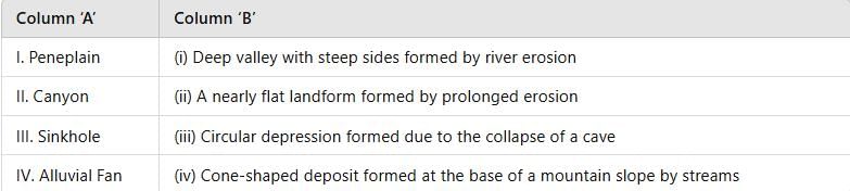
Match The following-

Detailed Solution: Question 14

  • Peneplain corresponds to a nearly flat landform formed by prolonged erosion (ii).
  • Canyon is a deep valley with steep sides formed by river erosion (i).
  • Sinkhole is a circular depression formed due to the collapse of a cave (iii).
  • Alluvial Fan is a cone-shaped deposit formed at the base of a mountain slope by streams (iv).

Test: Landforms And Their Evolution - Question 15

Which of the statements is/are true?

i. Stalactite: A formation hanging from the ceiling of a cave, formed by the deposition of calcium carbonate.

ii. Sinkhole: A depression or hole in the ground caused by the collapse of a surface layer.

iii. Braided Channel: A river channel that consists of a network of small channels separated by small and often temporary islands.

iv. Monadnock: An isolated hill or ridge of erosion-resistant rock rising above a peneplain.

Detailed Solution: Question 15

Stalactite: A structure that hangs from the ceiling of a cave formed by deposition of calcium carbonate from mineral-rich dripping water.

Sinkhole: A depression or hole formed when the surface layer collapses into an underground void, often where limestone has been dissolved.

Braided channel: A river channel comprising a network of small, interlacing channels separated by small, often temporary islands or bars, usually where there is high sediment load and variable flow.

Monadnock: An isolated hill or ridge of erosion-resistant rock that stands above the surrounding plain or peneplain because surrounding softer rocks have been worn away.

Therefore, all four statements are correct; option C is the right choice

178 videos|642 docs|170 tests
Information about Test: Landforms And Their Evolution Page
In this test you can find the Exam questions for Test: Landforms And Their Evolution solved & explained in the simplest way possible. Besides giving Questions and answers for Test: Landforms And Their Evolution, EduRev gives you an ample number of Online tests for practice
178 videos|642 docs|170 tests
Download as PDF