UPSC Exam  >  UPSC Tests  >  Test: UPSC Prelims (Past Year Questions) Geography 2015-20 - 1 - UPSC MCQ

Test: UPSC Prelims (Past Year Questions) Geography 2015-20 - 1 - UPSC MCQ


Test Description

30 Questions MCQ Test - Test: UPSC Prelims (Past Year Questions) Geography 2015-20 - 1

Test: UPSC Prelims (Past Year Questions) Geography 2015-20 - 1 for UPSC 2025 is part of UPSC preparation. The Test: UPSC Prelims (Past Year Questions) Geography 2015-20 - 1 questions and answers have been prepared according to the UPSC exam syllabus.The Test: UPSC Prelims (Past Year Questions) Geography 2015-20 - 1 MCQs are made for UPSC 2025 Exam. Find important definitions, questions, notes, meanings, examples, exercises, MCQs and online tests for Test: UPSC Prelims (Past Year Questions) Geography 2015-20 - 1 below.
Solutions of Test: UPSC Prelims (Past Year Questions) Geography 2015-20 - 1 questions in English are available as part of our course for UPSC & Test: UPSC Prelims (Past Year Questions) Geography 2015-20 - 1 solutions in Hindi for UPSC course. Download more important topics, notes, lectures and mock test series for UPSC Exam by signing up for free. Attempt Test: UPSC Prelims (Past Year Questions) Geography 2015-20 - 1 | 30 questions in 36 minutes | Mock test for UPSC preparation | Free important questions MCQ to study for UPSC Exam | Download free PDF with solutions
Test: UPSC Prelims (Past Year Questions) Geography 2015-20 - 1 - Question 1

What are the advantages of fertigation in agriculture?

1. Controlling the alkalinity of irrigation water is possible.

2. Efficient application of Rock Phosphate and all other phosphatic fertilizers is possible.

3. Increased availability of nutrients to plants is possible.

4. Reduction in the leaching of chemical nutrients is possible.

Select the correct answer using the code given below:

(2020)

Detailed Solution for Test: UPSC Prelims (Past Year Questions) Geography 2015-20 - 1 - Question 1
Fertigation is a method of fertilizer application in which fertilizer is incorporated within the irrigation water by the drip system. In this system, fertilizer solution is distributed evenly in irrigation.

S1: Drip irrigation also avoids water spillage on the field which could have promoted weed growth or increase soil alkalinity due to waterlogging. So, fertigation also helps control weed growth and cut down alkalinity.

S2: Urea, potash, and highly water-soluble fertilizers are available for applying through fertigation. In fact, Urea is well suited for injection in a micro-irrigation system. It is highly soluble and dissolves in the non-ionic form so that it does not react with other substances in the water. But, Rock phosphate is not soluble and thus not suitable.

S3: By this method, fertilizer use efficiency is increased from 80 to 90 percent as they are delivered directly to roots via a drip. As water and fertilizer are supplied evenly to all the crops through fertigation there is a possibility for getting 25-50 percent higher yield.

S4: This is correct since overapplication and soil waterlogging is avoided.

Test: UPSC Prelims (Past Year Questions) Geography 2015-20 - 1 - Question 2

Consider the following minerals:

1. Bentonite

2. Chromite

3. Kyanite

4. Sillimanite

In India, which of the above is/are officially designated as major minerals?

(2020)

Test: UPSC Prelims (Past Year Questions) Geography 2015-20 - 1 - Question 3

With reference to Ocean Mean Temperature(OMT), which of the following statements is/are correct?

1. OMT is measured upto a depth of 26 degree Celsius isotherm which is 129 meters in the south-western Indian Ocean during January-March.

2. OMT collected during January-march can be used in assessing whether the amount of rainfall in monsoon will be less or more than a certain long-term mean.

Select the correct answer using the code given below:

(2020)

Detailed Solution for Test: UPSC Prelims (Past Year Questions) Geography 2015-20 - 1 - Question 3
S1 and S2: The depth for the 26-degree isotherm is 50-100 meters, not 129 meters as the question suggests.

Ocean mean temperature is a better indicator of monsoon rainfall than sea surface temperatures. This is because OMT measures the ocean’s thermal energy, and on the other hand, SST is influenced by surface winds, evaporation, thick clouds, etc. OMT is a more stable indicator.

Test: UPSC Prelims (Past Year Questions) Geography 2015-20 - 1 - Question 4

Siachen Glacier is situated to the

(2020)

Test: UPSC Prelims (Past Year Questions) Geography 2015-20 - 1 - Question 5

With references to the history of India, consider the following pairs:
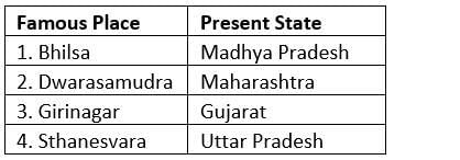
Which of the pairs given above is/are correctly matched?

(2020)

Detailed Solution for Test: UPSC Prelims (Past Year Questions) Geography 2015-20 - 1 - Question 5
S1: For e.g. Bhilsa topes about Bhilsa is a famous work on this site in MP.

S2: Dwarasamudra was in Karnataka, like a regal capital of the Hoysalas.

S3: This is straightforward.

S4: This is in Haryana. As of now, it is known to host a monastic cluster. Sthanesvara Mahadev Temple is also at Thanesar. It was here that the Pandavas prayed to Lord Shiva.

Test: UPSC Prelims (Past Year Questions) Geography 2015-20 - 1 - Question 6

Consider the following statements:

1. 36% of India’s districts are classified as “overexploited” or “critical” by the Central Ground Water Authority(CGWA).

2. CGWA was formed under the Environment (Protection) Act.

3. India has the largest area under groundwater irrigation in the world.

Which of the statements given above is/are correct?

(2020)

Detailed Solution for Test: UPSC Prelims (Past Year Questions) Geography 2015-20 - 1 - Question 6

S1: About 29% are such, not 36%. Out of the 5723 assessment units assessed jointly by State Ground Water Departments and CGWB in the country, 4078 are safe (71%), 550 are semi-critical (10%), 226 are critical (4%) and 839 are overexploited (15%).

S2: Central Ground Water Authority (CGWA) constituted under Section 3(3) of ‘The Environment (Protection) Act, (1986)’ regulates extraction of groundwater through guidelines which are updated regularly.

S3: At 39 million hectares (67% of its total irrigation), India has the world’s largest groundwater well-equipped irrigation system (China with 19 MHA is second, USA with 17 MHA is third).


Test: UPSC Prelims (Past Year Questions) Geography 2015-20 - 1 - Question 7

Consider the following statements:

1. Jet Streams occur in the Northern Hemisphere only.

2. Only some cyclones develop an eye.

3. The temperature inside the eye of a cyclone is nearly 10 degrees Celsius lesser than that of the surroundings.

Which of the statements given above is/are correct?

(2020)

Detailed Solution for Test: UPSC Prelims (Past Year Questions) Geography 2015-20 - 1 - Question 7
S1: This is obviously incorrect, they occur in the upper atmospheres of both hemispheres.

S2: Correct. Extra-tropical cyclones may not always have an eye, whereas mostly mature storms have well-developed eyes. Rapidly intensifying storms may develop an extremely small, clear, and circular eye, sometimes referred to as a pinhole eye.

S3: It is warmer and not colder for a tropical cyclone. The warmer temperature is what drives the storm.

Test: UPSC Prelims (Past Year Questions) Geography 2015-20 - 1 - Question 8

What is/are the advantage/advantages of zero tillage in agriculture?

1. Sowing of wheat is possible without burning the residue of the previous crop.

2. Without the need for the nursery of rice saplings, direct planting of paddy seeds in the wet soil is possible.

3. Carbon sequestration in the soil is possible.

Select the correct answer using the code given below:

(2020)

Detailed Solution for Test: UPSC Prelims (Past Year Questions) Geography 2015-20 - 1 - Question 8
Tillage is an agricultural land preparation through mechanical agitation which includes digging, stirring, and overturning.

S1: Zero tillage is the process where the crop seed will be sown through drillers without prior land preparation and disturbing the soil where previous crop stubbles are present. Zero tillage not only reduces the cost of cultivation it also reduces the soil erosion, crop duration and irrigation requirement, and weed effect which is better than tillage. Zero tillage (ZT) also called No-Tillage or Nil Tillage.

S2: Direct Seeded Rice Zero-Tillage DSR is an alternative crop establishment method for rice where seeds are sown directly without raising them in a nursery and can be done in zero-tillage conditions.

S3: If crops are not burnt and the land is prepared through mechanical agitation, carbon sequestration remains possible.

Test: UPSC Prelims (Past Year Questions) Geography 2015-20 - 1 - Question 9

“The crop is subtropical in nature. A hard frost is injurious to it. It requires at least 210 frost-free days and 50 to 100 centimeters of rainfall for its growth. A light well-drained soil capable of retaining moisture is ideally suited for the cultivation of the crop.” Which one of the following is that crop?

(2020)

Test: UPSC Prelims (Past Year Questions) Geography 2015-20 - 1 - Question 10

With reference to the current trends in the cultivation of sugarcane in India, consider the following statements:

1. A substantial saving in seed material is made when ‘bud chip settlings are raised in a nursery and transplanted in the main field.

2. When direct planting of setts is done, the germination percentage is better with single-budded setts as compared to setts with many buds.

3. If bad weather conditions prevail when setts are directly planted, single-budded setts have better survival as compared to large sets.

4. Sugarcane can be cultivated using settlings prepared from tissue culture.

Which of the statements given above is/are correct?

(2020)

Detailed Solution for Test: UPSC Prelims (Past Year Questions) Geography 2015-20 - 1 - Question 10
Conventional method of sugarcane planting requires 7 to 8 tonnes of seed cane per hectare and this is the main reason for the slow rate of speed and varietal replacement. Sugarcane being a long duration crop and heavy biomass producer requires about 1500 to 2500 mm water.

Keeping in mind the likely to be faced situations in the future, the ICAR-Sugarcane Breeding Institute (ICAR-SBI) has developed an integrated sugarcane cultivation model called Settling Transplanting Technology (STT). Components of the model are listed below:

  • High yielding and better quality varieties

  • Raising and transplanting of settlings derived from single bud setts/ bud chips

  • Sub-surface drip irrigation and fertigation

  • Wider row planting

  • Intercropping

  • Trash mulching

  • Multiple ratooning

  • Mechanization

S1: Transplanting sugarcane single-bud/ bud-chip settlings can save seed cane requirement up to 80 percent besides providing healthy plants and good field establishment. It is less expensive and labor-saving in comparison with conventional sett planting.

Other options are spaced transplanting (STP) and polybag / pro-tray nursery.

S2 and S3: Reverse is true.

S4: Yes, tissue culture or vegetative propagation (a subset of TC), can be used to germinate and grow these settlings which can be transplanted in the field later.

Test: UPSC Prelims (Past Year Questions) Geography 2015-20 - 1 - Question 11

In the context of India, which of the following is/are considered to be practice(s) of eco-friendly agriculture?

1. Crop diversification

2. Legume intensification

3. Tensiometer uses

4. Vertical farming

Which of the statements given above is/are correct?

(2020)

Test: UPSC Prelims (Past Year Questions) Geography 2015-20 - 1 - Question 12

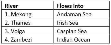
Consider the following pairs:

Which of the statements given above is/are correct?

(2020)

Test: UPSC Prelims (Past Year Questions) Geography 2015-20 - 1 - Question 13

With reference to the cultivation of Kharif crops in India in the last five years, consider the following statements:

1. Area under rice cultivation is the highest.

2. Area under the cultivation of jowar is more than that of oilseeds.

3. Area of cotton cultivation is more than that of sugarcane.

4. Area under sugarcane cultivation has steadily decreased.

Which of the statements given above are correct?

(2019)

Detailed Solution for Test: UPSC Prelims (Past Year Questions) Geography 2015-20 - 1 - Question 13
The chart below (from Ministry report 2016-17) clarifies all the statements. S2 and S3 are wrong since the area under coarse grains is smaller than that of oil seeds and the area under sugarcane do not show a steadily increasing trend, rather fluctuates.

Test: UPSC Prelims (Past Year Questions) Geography 2015-20 - 1 - Question 14

Recently, scientists observed the merger of giant ‘blackholes’ billions of light-years away from the Earth. What is the significance of this observation?

(2019)

Detailed Solution for Test: UPSC Prelims (Past Year Questions) Geography 2015-20 - 1 - Question 14
Two black holes recently collided to create a larger one – the biggest black hole merger yet detected. It has a mass more than 80 times that of the sun. The resulting energy injected into the fabric of spacetime was also record-breaking, with five sun’s worth of mass released in the form of gravitational waves as the two holes spiraled in towards each other. Such titanic amounts of energy meant that the signal was still detectable by the time it reached gravitational wave detectors on Earth. It produced a record-breaking result – the most distant collision detected so far, nine billion light-years away.

Test: UPSC Prelims (Past Year Questions) Geography 2015-20 - 1 - Question 15

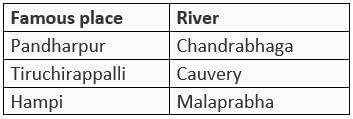
Consider the following pairs

Which of the pairs given above are correctly matched?

(2019)

Detailed Solution for Test: UPSC Prelims (Past Year Questions) Geography 2015-20 - 1 - Question 15
The Bhima River is a major river in Western India and South India. The river is also referred to as Chandrabhaga River, especially at Pandharpur, as it resembles the shape of the Moon. Hampi is situated on the banks of the Tungabhadra River in the eastern part of central Karnataka. The two major rivers draining Tiruchirappalli are the Kaveri and its tributary the Kollidam.

Test: UPSC Prelims (Past Year Questions) Geography 2015-20 - 1 - Question 16

In the context of which of the following do some scientists suggest the use of cirrus cloud thinning technique and the injection of sulphate aerosol into stratosphere?

(2019)

Detailed Solution for Test: UPSC Prelims (Past Year Questions) Geography 2015-20 - 1 - Question 16
The ability of stratospheric sulfate aerosols to create a global dimming effect has made them a possible candidate for use in solar radiation management climate engineering projects to limit the effect and impact of climate change due to rising levels of greenhouse gases. Delivery of precursor sulfide gases such as sulfuric acid, hydrogen sulfide (H2S), or sulfur dioxide (SO2) by artillery, aircraft, and balloons has been proposed. Cirrus cloud thinning is a proposed form of climate engineering. Cirrus clouds are high cold ice that, like other clouds, both reflect sunlight and absorb warming infrared radiation. However, they differ from other types of clouds in that, on average, infrared absorption outweighs sunlight reflection, resulting in a net warming effect on the climate. Therefore, thinning or removing these clouds would reduce their heat-trapping capacity, resulting in a cooling effect on Earth’s climate.

Test: UPSC Prelims (Past Year Questions) Geography 2015-20 - 1 - Question 17

On 21st June, the Sun

(2019)

Detailed Solution for Test: UPSC Prelims (Past Year Questions) Geography 2015-20 - 1 - Question 17
For that hemisphere, the summer solstice is when the Sun reaches its highest position in the sky and is the day with the longest period of daylight. At the pole, there is continuous daylight around the summer solstice.

Test: UPSC Prelims (Past Year Questions) Geography 2015-20 - 1 - Question 18

What is common to the places known as Aliyar, Isapur, and Kangsabati?

(2019)

Detailed Solution for Test: UPSC Prelims (Past Year Questions) Geography 2015-20 - 1 - Question 18
They are all water reservoirs.

Test: UPSC Prelims (Past Year Questions) Geography 2015-20 - 1 - Question 19

Why are dewdrops not formed on a cloudy night?

(2019)

Detailed Solution for Test: UPSC Prelims (Past Year Questions) Geography 2015-20 - 1 - Question 19
The dew formation is more when the sky is clear and less when it is cloudy. When the sky is clear and the trees and plants are cooler at night, there is more evaporation of water and hence more dew formation. But when it is cloudy, trees and plants do not get cool in the night and hence there is less dew formation. As the sun rises high in the sky, these dew drops evaporate into air.

Test: UPSC Prelims (Past Year Questions) Geography 2015-20 - 1 - Question 20

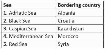
Consider the following pairs:

Which of the pair given above are correctly matched?

(2019)

(a) 1, 2 and 4 only

(b) 1, 3 and 4 only

(c) 2 and 5 only

(d) 1, 2, 3, 4 and 5


Detailed Solution for Test: UPSC Prelims (Past Year Questions) Geography 2015-20 - 1 - Question 20

The countries with coasts on the Adriatic are Albania, Bosnia and Herzegovina, Croatia, Italy, Montenegro, and Slovenia.


Test: UPSC Prelims (Past Year Questions) Geography 2015-20 - 1 - Question 21

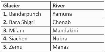
Consider the following pairs:

Which of the pairs given above are correctly matched?

(2019)

Detailed Solution for Test: UPSC Prelims (Past Year Questions) Geography 2015-20 - 1 - Question 21
S3: Mandakini originates from the Chorabari Glacier near Kedarnath in Uttarakhand, India. Mandakini is fed by the Vasukiganga River at Sonprayag.

S5: The Manas river system as a whole in Bhutan constitutes a length of 3,200 kilometers (2,000 mi), the main stem of the river is the Manas or Gongri river, which originates in the West Kameng District of Arunachal Pradesh in India. Zemu is located in Sikkim.

Test: UPSC Prelims (Past Year Questions) Geography 2015-20 - 1 - Question 22

Which of the following has/have shrunk immensely/dried up in the recent past due to human activities?

(2018)

1. Aral Sea

2. Black Sea

3. Lake Baikal

Select the correct answer using the codes given below:

Detailed Solution for Test: UPSC Prelims (Past Year Questions) Geography 2015-20 - 1 - Question 22
S1: The Aral Sea is a saline lake located in Central Asia that was once the world’s fourth largest salt lake. In the 1960s the Aral Sea, which was the drainage basin for Kyrgyzstan, Turkmenistan, Tajikistan, Uzbekistan, Pakistan, Afghanistan, and Kazakhstan, began to shrink as the Soviet Union began to divert water for agricultural purposes. The Aral Sea, which was once 26,300 square miles in size had decreased in size by 2007 to only 10% of its original area. Lake Baikal hasn’t shrunk immensely yet. Certainly its water is shrinking. But, it’s not ‘immense’ like Aral Sea. If one has to go for two options, the intensity of shrinkage should be either equal or comparable. Case of Aral Sea is extreme and Lake Baikal’s present condition, which is better, is no comparison to Aral Sea’s fate.

Test: UPSC Prelims (Past Year Questions) Geography 2015-20 - 1 - Question 23

Consider the following statements:

1. The Earth’s magnetic field has reversed every few hundred thousand years.

2. When the Earth was created more than 4000 million years ago, there was 54% oxygen and no carbon dioxide.

3. When living organisms originated, they modified the early atmosphere of the Earth.

Which of the statements given above is/are correct?

(2018)

Detailed Solution for Test: UPSC Prelims (Past Year Questions) Geography 2015-20 - 1 - Question 23
S1: A change in the Earth’s magnetic field resulting in the magnetic north being aligned with the geographic south, and the magnetic south being aligned with the geographic north is called as geomagnetic reversal. Complete magnetic reversals have happened every 200,000 to 300,000 years over the past 20 million years. But that regularity hasn’t continued, as the last known reversal occurred roughly 780,000 years ago.

S2: Between 4.5 and 2.5 billion years (the Archaean and Proterozoic time), the earliest atmosphere contained carbon dioxide (CO2), methane (CH4), water vapour (H2O), carbon monoxide (CO), a little nitrogen (N), and hydrogen (H).

S3: When living organisms originated, they did not affect the early atmosphere because they lacked the ability to do so. Early atmosphere of earth was modified by solar winds. This happened not only in case of the earth, but also in all the terrestrial planets, which were supposed to have lost their primordial atmosphere through the impact of solar winds.

Test: UPSC Prelims (Past Year Questions) Geography 2015-20 - 1 - Question 24

With reference to the circumstances in Indian agriculture, the concept of “Conservation Agriculture” assumes significance” Which of the following fall under the Conservation Agriculture?

1. Avoiding the monoculture practices

2. Adopting minimum tillage

3. Avoiding the cultivation of plantation crops

4. Using crop residues to cover soil surface

5. Adopting spatial and temporal crop sequencing/crop rotations

Select the correct answer using the code given below:

(2018)

Detailed Solution for Test: UPSC Prelims (Past Year Questions) Geography 2015-20 - 1 - Question 24
Conservation agriculture (CA) can be defined by a statement given by the Food and Agricultural Organization of the United Nations as “a concept for resource-saving agricultural crop production that strives to achieve acceptable profits together with high and sustained production levels while concurrently conserving the environment”

The 3 principles of CA are:

(i) Minimum tillage and soil disturbance

(ii) Permanent soil cover with crop residues and live mulches

(iii) Crop rotation and intercropping

Test: UPSC Prelims (Past Year Questions) Geography 2015-20 - 1 - Question 25

The term “sixth mass extinction/sixth extinction” is often mentioned in the news in the context of the discussion of

(2018)

Detailed Solution for Test: UPSC Prelims (Past Year Questions) Geography 2015-20 - 1 - Question 25
The Holocene extinction, otherwise referred to as the Sixth extinction or Anthropocene extinction, is the ongoing extinction event of species during the present Holocene epoch, mainly as a result of human activity. The large number of extinctions spans numerous families of plants and animals, including mammals, birds, amphibians, reptiles and arthropods. With widespread degradation of highly bio-diverse habitats such as coral reefs and rainforests, as well as other areas, the vast majority of these extinctions is thought to be undocumented, as we are either not even aware of the existence of the species before they go extinct, or we haven’t yet discovered their extinction. The current rate of extinction of species is estimated at 100 to 1,000 times higher than natural background rates.

Test: UPSC Prelims (Past Year Questions) Geography 2015-20 - 1 - Question 26

Which one of the following is an artificial lake?

(2018)

Detailed Solution for Test: UPSC Prelims (Past Year Questions) Geography 2015-20 - 1 - Question 26

Kodaikanal Lake, also known as Kodai Lake is a manmade lake located in the Kodaikanal city in Dindigul district in Tamil Nadu, India. Kodaikanal Lake is in the Palni Hills. It is starfish-shaped but with four points, centrally located in the town of Kodaikanal and is surrounded by lush green hills of the Northwestern Palani Hills.


Test: UPSC Prelims (Past Year Questions) Geography 2015-20 - 1 - Question 27

Which of the following is/are the possible consequence/s of heavy sand mining in riverbeds?

(2018)

1. Decreased salinity in the river

2. Pollution of groundwater

3. Lowering of the water-table

Select the correct answer using the code given below:

Detailed Solution for Test: UPSC Prelims (Past Year Questions) Geography 2015-20 - 1 - Question 27
The removal of sand from the river bed increases the velocity of the flowing water, with the distorted flow-regime eventually eroding the river banks. Sand acts like a sponge, which helps in recharging the water table; its progressive depletion in the river is accompanied by declining water tables in the nearby areas. Depletion of sand in the stream bed causes the deepening of rivers and estuaries, and the enlargement of river mouths and coastal inlets. It leads to saline-water intrusion. Sand acts as an efficient filter for various pollutants and thus maintains the quality of water in rivers and other aquatic ecosystems.

Test: UPSC Prelims (Past Year Questions) Geography 2015-20 - 1 - Question 28

With reference to agricultural soils, consider the following statements:

1. A high content of organic matter in soil drastically reduces its water holding capacity.

2. Soil does not play any role in the sulphur cycle.

3. Irrigation over a period of time can contribute to the salinization of some agricultural lands.

Which of the statements given above is/are correct?

(2018)

Detailed Solution for Test: UPSC Prelims (Past Year Questions) Geography 2015-20 - 1 - Question 28
S1: Soil water holding capacity is the amount of water that a given soil can hold for crop use. Soil texture and organic matter are the key components that determine soil water holding capacity. Organic matter influences the physical conditions of a soil in several ways. Plant residues that cover the soil surface protect the soil from sealing and crusting by raindrop impact, thereby enhancing rainwater infiltration and reducing runoff. Each 1 percent increase in soil organic matter helps soil hold 20,000 gallons more water per acre.

S2: Sulphur is one of three nutrients that are cycled between the soil, plant matter and the atmosphere. The sulphur cycle describes the movement of sulphur through the atmosphere, mineral and organic forms, and through living things. Although sulphur is primarily found in sedimentary rocks, it is particularly important to living things because it is a component of many proteins

S3: Salinization is a major problem associated with irrigation, because deposits of salts build up in the soil and can reach levels that are harmful to crops. Hence statement 3 is correct.

Test: UPSC Prelims (Past Year Questions) Geography 2015-20 - 1 - Question 29

Consider the following statements:

1. The Barren Island volcano is an active volcano located in the Indian Territory.

2. Barren Island lies about 140 km east of Great Nicobar

3. The last time the Barren Island volcano erupted was in 1991 and it has remained inactive since then.

Which of the statements given above is/are correct?

(2018)

Detailed Solution for Test: UPSC Prelims (Past Year Questions) Geography 2015-20 - 1 - Question 29
Barren Island, a possession of India in the Andaman Sea about 140 km NE of Port Blair in the Andaman Islands, is the only historically active volcano along the N-S-trending volcanic arc extending between Sumatra and Burma (Myanmar). The 354-m-high island is the emergent summit of a volcano that rises from a depth of about 2250 m.

The Barren Island volcano, on a remote uninhabited island off the country’s eastern coast, had been lying dormant for more than 150 years until it saw a major eruption in 1991. Since then it has shown intermittent activity, including eruptions in 1995 and 2005.

Test: UPSC Prelims (Past Year Questions) Geography 2015-20 - 1 - Question 30

Consider the following pairs:

Which of the pairs given above are correctly matched?

(2018)

Detailed Solution for Test: UPSC Prelims (Past Year Questions) Geography 2015-20 - 1 - Question 30
The autonomous community of Catalonia occupies a triangular area in the north-eastern corner of Spain. It is bordered by France and Andorra to the north, the Mediterranean Sea to the east, the autonomous community of Valencia to the south, and the autonomous community of Aragon to the west. The Republic of Crimea, officially part of Ukraine, lies on a peninsula stretching out from the south of Ukraine between the Black Sea and the Sea of Azov. It is separated from Russia to the east by the narrow Kerch Strait. Mindanao, island, the second largest (after Luzon) in the Philippines, in the southern part of the archipelago, surrounded by the Bohol, Philippine, Celebes, and Sulu seas. Oromia is one of the nine ethnically based regional states of Ethiopia, covering 284,538 square kilometres.
Information about Test: UPSC Prelims (Past Year Questions) Geography 2015-20 - 1 Page
In this test you can find the Exam questions for Test: UPSC Prelims (Past Year Questions) Geography 2015-20 - 1 solved & explained in the simplest way possible. Besides giving Questions and answers for Test: UPSC Prelims (Past Year Questions) Geography 2015-20 - 1, EduRev gives you an ample number of Online tests for practice
Download as PDF