UPSC Exam  >  UPSC Tests  >  Prelims Map Based Questions - 1 - UPSC MCQ

Prelims Map Based Questions - 1 - UPSC MCQ


Test Description

20 Questions MCQ Test - Prelims Map Based Questions - 1

Prelims Map Based Questions - 1 for UPSC 2024 is part of UPSC preparation. The Prelims Map Based Questions - 1 questions and answers have been prepared according to the UPSC exam syllabus.The Prelims Map Based Questions - 1 MCQs are made for UPSC 2024 Exam. Find important definitions, questions, notes, meanings, examples, exercises, MCQs and online tests for Prelims Map Based Questions - 1 below.
Solutions of Prelims Map Based Questions - 1 questions in English are available as part of our course for UPSC & Prelims Map Based Questions - 1 solutions in Hindi for UPSC course. Download more important topics, notes, lectures and mock test series for UPSC Exam by signing up for free. Attempt Prelims Map Based Questions - 1 | 20 questions in 25 minutes | Mock test for UPSC preparation | Free important questions MCQ to study for UPSC Exam | Download free PDF with solutions
Prelims Map Based Questions - 1 - Question 1

Which of the following lakes are correctly matched which the respective countries they are situated in?

  1. Lake Baikal: Russia
  2. Lake Akan: Indonesia
  3. Lake Matano: Japan
  4. Qinghai Lake: China

Select the correct option from the codes given below:

Detailed Solution for Prelims Map Based Questions - 1 - Question 1

Option 1 and 4 are correctly matched. Option 2 and 3 are reversed.

Major lakes of Asia

  • Lake Baikal is situated in Russia;
  • Lake Akanis situated in Japan;
  • Qinghai Lake or Lake Khanka are situated in China;
  • Dal Lake, Chilka, Vembanada, Pullicat and Sukhnaare situated inIndia;
  • Lake Matano is situated in Indonesia.
Prelims Map Based Questions - 1 - Question 2

If one is travelling from Somalia to Philippines via sea route along coastline, arrange the following islands one will encounter in sequential order:

  1. Phuket Island
  2. Socotra Island
  3. Borneo Island
  4. Sumatra Island

Select the correct option from the codes given below:

Detailed Solution for Prelims Map Based Questions - 1 - Question 2

Option (b) is correct:Socotra (Yemen)-Phuket (Thailand)-Sumatra (Indonesia)-Borneo(Indonesia)

1 Crore+ students have signed up on EduRev. Have you? Download the App
Prelims Map Based Questions - 1 - Question 3

Which of the following plateaus is surrounded by the Greater Hinggan Mountains in the east, the Yin Mountains to the south, the Altai Mountains to the west, and the Sayan and Khentii mountains to the north?

Detailed Solution for Prelims Map Based Questions - 1 - Question 3

Option (d) is the correct answer: The above description describes Mangolian Plateau

Prelims Map Based Questions - 1 - Question 4

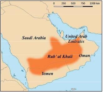
Rub-al-Khali Desert in the southern Arabian Peninsula constitutes the largest portion of the Arabian Desert. It is expanded in which of the following countries?

  1. Oman
  2. Qatar
  3. Kuwait
  4. Yemen
  5. United Arab Emirates

Select the correct option from the codes given below:

Detailed Solution for Prelims Map Based Questions - 1 - Question 4

Option (b) is the correct answer: It lies mainly in southeastern Saudi Arabia, with lesser portions in Yemen, Oman, and the United Arab Emirates.

Rubʿ al-Khali Desert

  • Rubʿ al-Khali is a vast desert region in the southern Arabian Peninsula, constituting the largest portion of the Arabian Desert. 
  • It covers an area of about 250,000 square miles (650,000 square km) in a structural basin lying mainly in southeastern Saudi Arabia, with lesser portions in Yemen, Oman, and the United Arab Emirates.
  • The Rubʿ al-Khali is the largest area of continuous sand in the world. It occupies more than one-fourth of Saudi Arabia’s total area.
Prelims Map Based Questions - 1 - Question 5

Arrange the following Gulfs in east to west order:

  1. Gulf of Oman
  2. Gulf of Aden
  3. Gulf of Thailand
  4. Persian Gulf

Select the correct option from the codes given below:
Detailed Solution for Prelims Map Based Questions - 1 - Question 5
  • Gulf of Thailand: Located in Southeast Asia, it is the easternmost of the gulfs listed.
  • Gulf of Oman: Situated to the west of the Gulf of Thailand, it opens into the Arabian Sea.
  • Persian Gulf: Found to the west of the Gulf of Oman, it lies between Iran and the Arabian Peninsula.
  • Gulf of Aden: The westernmost gulf listed, it is located between Yemen and Somalia.
Thus, the correct order from east to west is: Gulf of Thailand, Gulf of Oman, Persian Gulf, Gulf of Aden.
Prelims Map Based Questions - 1 - Question 6

Consider the following statements regarding Sinai Peninsula:

  1. Sinai Peninsula located in the Asian part of Egypt between the Mediterranean Sea to the north, and the Red Sea to the south.
  2. It shares maritime or territorial boundary with Israel, Jordan and Gaza Strip.

Which of the above statement/s is/are correct?

Detailed Solution for Prelims Map Based Questions - 1 - Question 6
  • Sinai Peninsula located in the Asian part of Egypt between the Mediterranean Sea to the north, and the Red Sea to the south. The Sinai Peninsula is defi ned by the Suez Canal and the Gulf of Suez in west and the Gulf of Aqaba in south east.
  • Countries with international borders to Sinai are Palestinian territories (Gaza Strip) and Israel, Egypt shares maritime borders in the Sinai with Jordan and Saudi Arabia.
Prelims Map Based Questions - 1 - Question 7

Which of the following statement is/are correct?

  1. Manchurian Plain- formed by the Amur River
  2. Turanian Plain-formed by the two Asian Rivers. the Amu Darya and Syr Darya
  3. Aral Sea- Located between Kazakhstan and China

Select the correct code from below.

Detailed Solution for Prelims Map Based Questions - 1 - Question 7

Manchurian Plain: Situated along the Amur River, the Manchurian Plain spans approximately 135,000 square miles, all below an elevation of 1000 feet above sea level. Notable cities within the Mukden Triangle, including Anshan, Shenyang, and Fushun, are strategically located in the northern part of China. The Sungari River, along with its northern tributary, the Nen River, and the southern Liao River, drain the plain.

Turanian Plain: The Turanian Plain, formed by the Amu Darya and Syr Darya rivers, extends across Turkmenistan, Uzbekistan, and Kazakhstan. This basin plain encompasses the Karakum and Kyzylkum deserts, separated by the Amu Darya valley. Vegetation in this arid plain is limited to xerophytic shrubs and short grasses. The region features hills reaching elevations of up to 3300 feet and depressions below sea level.

Aral Sea: Positioned between Kazakhstan and Uzbekistan, the Aral Sea, once the world's fourth-largest inland water body, is now a shallow, semi-arid depression. The Amu Darya and Syr Darya rivers flow through this region, contributing to the formation of the Aral Sea. The depression of the Aral Sea originated during the Neogene Period.

Prelims Map Based Questions - 1 - Question 8

Aral Sea is enclosed between which of the following two countries?

Detailed Solution for Prelims Map Based Questions - 1 - Question 8

Aral Sea is enclosed between Uzbekistan and Kazakhstan.

Aral Sea

  • Once the fourth-largest freshwater lake in the world, the Aral Sea today is a tenth of its original size.
  • The North Aral Sea – the top half of the body of water – lies in Kazakhstan. The South Aral Sea, which consist of a strip of water in the west and a dried-out basin in the east, sits in Uzbekistan.
Prelims Map Based Questions - 1 - Question 9

Travelling from west to east, arrange the following capital cities in sequential order:

  1. Riyadh
  2. Ankara
  3. Damascus
  4. Tehran
  5. Kuwait City

Select the correct option from the codes given below:
Detailed Solution for Prelims Map Based Questions - 1 - Question 9

Ankara (Turkey)-Damascus (Syria)-Riyad (Saudi Arabia)-Kuwait City (Kuwait)-Tehran (Iran).

Prelims Map Based Questions - 1 - Question 10

Match the following correctly:

Select the correct option from the codes given below:
Prelims Map Based Questions - 1 - Question 11

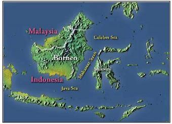
Which of the following statement is/are correct regarding Makassar Strait?

  1. It separates Borneo (Kalimantan) and Celebes Island
  2. It connects Celebes Sea with Java Sea.
  3. Select the correct option from the codes given below:
Detailed Solution for Prelims Map Based Questions - 1 - Question 11

Makassar Strait 

Prelims Map Based Questions - 1 - Question 12

Which of the following seas is/are not a part of Pacifi c Ocean?

  1. Sulu Sea
  2. Arafura Sea
  3. Kara Sea
  4. Laptev Sea

Select the correct option from the codes given below:
Detailed Solution for Prelims Map Based Questions - 1 - Question 12

Option (d) is correct: Kara and Laptev Sea are a part of Arctic Ocean.

Prelims Map Based Questions - 1 - Question 13

Arrange the following seas in north to south order:

  1. East China Sea
  2. Yellow Sea
  3. Sea of Okhotsk
  4. Philippines Sea

Select the correct option from the codes given below:
Detailed Solution for Prelims Map Based Questions - 1 - Question 13

Option (c) is correct: Sea of Okhotsk-Yellow Sea-East China Sea-Philippines Sea

Prelims Map Based Questions - 1 - Question 14

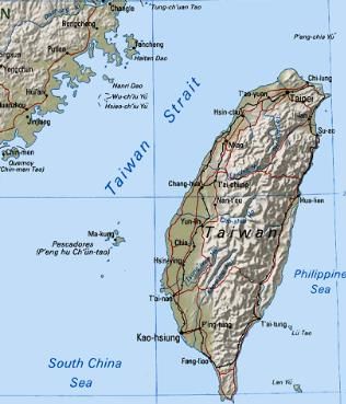
The Formosa Strait also known as Taiwan Strait connects which of the following seas?

Detailed Solution for Prelims Map Based Questions - 1 - Question 14

Option (a) is the correct answer: Formosa Strait connects East China Sea with South China Sea.

Taiwan Strait

Prelims Map Based Questions - 1 - Question 15

The Pamir Knot is the junction of five mountain ranges. Which of the following is/are not one of them?

  1. KunlunMountains
  2. Zagros Mountains
  3. Karakoram Mountains
  4. Kirthar Mountains
  5. Hindu Kush Mountains

Which of the following is/are not one of them?

Detailed Solution for Prelims Map Based Questions - 1 - Question 15

Option (d) is the correct answer: Zagros Mountains and Kirthar Mountains are not one of them
The Pamir Knot is the junction of five mountain ranges they are the Tien Shan, the Hindu Kush, the Kunlun, the Karakoram, and the Himalayan ranges.

Pamirs Knot

  • The Pamirs are the most famous mountain convergence zone in the world. It is the largest mountain convergence zone.
  • It lies in the hinterland of Eurasia and extends across China, Tajikistan and Afghanistan with an area of more than 100,000 km2. The Pamir Mountains were created by crustal tectonics.
  • They spread from the south to the north of the Qinghai-Tibetan Plateau and converged on the Pamirs.
  • Pamir Mountains are known as ‘The Roof of the World’. There are suture lines resulting from the collision between the Indian and Eurasian plates, which occurred at the closure of the Paleo-Tethys period.
Prelims Map Based Questions - 1 - Question 16

Consider the following statements:

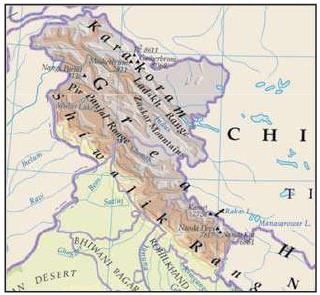
  1. Ladakh Plateau is situated between Karakoram and Himalaya mountain ranges.
  2. Tibetan Plateau is situated between Kulun and Himalayan Mountain range.
  3. Armenian Plateau is bordered by Caspian and the Black Sea.

Which of the above statement/s is/are correct?

Detailed Solution for Prelims Map Based Questions - 1 - Question 16

All of the above statements are correct.

Prelims Map Based Questions - 1 - Question 17

Arrange the following cities from East to West:

  1. Mandalay
  2. Kolkata
  3. Kunming
  4. Dhaka

Select the correct option from the codes given below:

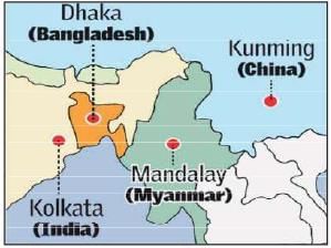
Detailed Solution for Prelims Map Based Questions - 1 - Question 17

KunmingMandalay-Dhaka-Kolkata

Bullet train between India and China

  • China is planning a bullet train from Kolkata to its Kunming City.
  • The service is also expected to give a thrust to trade and commerce in the Bangladesh-ChinaIndia-Myanmar (BCIM) Economic Corridor.
  • The BCIM project, initiated by China, is projected to run through Mandalay in Myanmar, Chittagong and Dhaka in Bangladesh, terminating in Kolkata.
Prelims Map Based Questions - 1 - Question 18

Consider the following islands:

  1. Paracel Islands
  2. Pratas Islands
  3. Spratly Islands
  4. Senkaku Islands

If one is travelling from South China Sea to East China Sea, arrange the following islands one will encounter in sequential order and select the correct option from the codes given below:

Detailed Solution for Prelims Map Based Questions - 1 - Question 18

Sequential Order of Islands from South China Sea to East China Sea:
To determine the sequential order of the islands from the South China Sea to the East China Sea, let's consider the given options and analyze the location of each island.
A: 3-1-2-4
B: 4-2-1-3
C: 4-1-3-2
D: 3-2-4-1
To find the correct option, we need to understand the geographical positioning of these islands.
1. Paracel Islands: The Paracel Islands are located in the South China Sea, east of Vietnam and south of China's Hainan Island.
2. Pratas Islands: The Pratas Islands (also known as Dongsha Islands) are situated in the northern part of the South China Sea, approximately 340 kilometers southeast of Hong Kong.
3. Spratly Islands: The Spratly Islands are a group of islands, reefs, and shoals located in the South China Sea. They are spread across an area of approximately 425,000 square kilometers and are claimed by multiple countries, including China, Taiwan, Vietnam, Malaysia, and the Philippines.
4. Senkaku Islands: The Senkaku Islands (also known as Diaoyu Islands) are a group of uninhabited islands located in the East China Sea. They are currently under the administration of Japan but are also claimed by China and Taiwan.
Therefore, the correct option is A: 3-1-2-4.

Prelims Map Based Questions - 1 - Question 19

Consider the following countries:

  1. Armenia
  2. Azerbaijan
  3. Russia
  4. Uzbekistan
  5. Romania
  6. Iraq

Which of the above countries touches the boundary of either the Black Sea or the Caspian Sea?

Detailed Solution for Prelims Map Based Questions - 1 - Question 19

Option (d) is correct: Iraq, Uzbekistan and Armenia does not touch the boundary of either the Black Sea or the Caspian Sea.

The Caspian Sea and Black Sea

  • The Caspian Sea: The Caspian Sea is the Earth’s largest inland body of water. It lies at the junction of Europe and Asia, with the Caucasus Mountains to the west and the steppes of Central Asia to the east. It is bordered by Russia to the northwest, Azerbaijan to the west, Iran to the south, Turkmenistan to the southeast and Kazakhstan to the northeast.
  • Black Sea: The world’s most isolated sea, the Black Sea, is connected to the oceans via the Mediterranean through the Bosphorus, and linked with the Sea of Azov in the northeast through the Kerch Strait. Its catchment area covers an area six times larger than its surface. The Danube discharges into the Black Sea at the Danube Delta, thus Danube water quality is directly connected with the Black Sea’s status. The Black Sea Protection Commission is responsible for the sea’s sustainable management. The countries share a border with the Black Sea includes Romania, Turkey, Bulgaria, Ukraine, Russia, and Georgia. This body of water is also surrounded by the Pontic, Caucasus, and Crimean Mountains in the south, east and north respectively. It is also constrained by Strandzha mountains to the southwest and Dobrogea Plateau to the northwest.
Prelims Map Based Questions - 1 - Question 20

Golan Heights touches the boundary of which of the following countries?

  1. Syria
  2. Jordan
  3. Lebanon
  4. Egypt
  5. Israel

Select the correct option from the codes given below:

Detailed Solution for Prelims Map Based Questions - 1 - Question 20

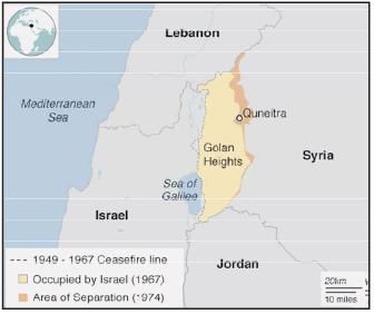
It touches the boundary of Syria, Jordan, Lebanon and Israel.

Information about Prelims Map Based Questions - 1 Page
In this test you can find the Exam questions for Prelims Map Based Questions - 1 solved & explained in the simplest way possible. Besides giving Questions and answers for Prelims Map Based Questions - 1, EduRev gives you an ample number of Online tests for practice

Top Courses for UPSC

Download as PDF

Top Courses for UPSC