UPSC Exam  >  UPSC Tests  >  Prelims Map Based Questions - 2 - UPSC MCQ

Prelims Map Based Questions - 2 - UPSC MCQ


Test Description

20 Questions MCQ Test - Prelims Map Based Questions - 2

Prelims Map Based Questions - 2 for UPSC 2024 is part of UPSC preparation. The Prelims Map Based Questions - 2 questions and answers have been prepared according to the UPSC exam syllabus.The Prelims Map Based Questions - 2 MCQs are made for UPSC 2024 Exam. Find important definitions, questions, notes, meanings, examples, exercises, MCQs and online tests for Prelims Map Based Questions - 2 below.
Solutions of Prelims Map Based Questions - 2 questions in English are available as part of our course for UPSC & Prelims Map Based Questions - 2 solutions in Hindi for UPSC course. Download more important topics, notes, lectures and mock test series for UPSC Exam by signing up for free. Attempt Prelims Map Based Questions - 2 | 20 questions in 25 minutes | Mock test for UPSC preparation | Free important questions MCQ to study for UPSC Exam | Download free PDF with solutions
Prelims Map Based Questions - 2 - Question 1

Arrange the following Islands of Pacifi c Ocean in north to south order:

  1. Volcano Islands
  2. Bonin Islands
  3. Kamchatka Peninsula
  4. Kuril Islands

Select the correct option from the codes given below:

Detailed Solution for Prelims Map Based Questions - 2 - Question 1

Kamchatka PeninsulaKuril Islands (Russia)-Bonin Islands (Japan)-VolcanoIslands (Japan).

Prelims Map Based Questions - 2 - Question 2

Consider the following statements:

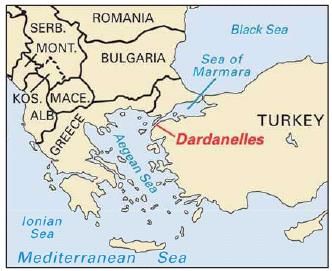
  1. Dardanelles Strait links Sea of Marmara with Aegean Sea.
  2. The Aegean is located between between the mainlands of Greece,Bulgaria and Turkey.

Which of the above statement/s is/are correct?

Detailed Solution for Prelims Map Based Questions - 2 - Question 2

The Aegean is located between the mainland of Greece and Turkey, respectively.

Dardanelles Strait and the Aegean Sea

  • Dardanelles is a narrow strait in northwestern Turkey linking the Aegean Sea with the Sea of Marmara.  The Aegean Sea is an elongated embayment of the Mediterranean Sea and an important natural feature of the Mediterranean region.
  • The Aegean is located between the southern Balkan and the Anatolian peninsulas, between the mainlands of Greece and Turkey, respectively. In the north, it is connected to the Marmara Sea and the Black Sea by the Dardanelles and the Bosporus.

1 Crore+ students have signed up on EduRev. Have you? Download the App
Prelims Map Based Questions - 2 - Question 3

Which of the following rivers does not drain their water in Pacifi c Ocean?

Detailed Solution for Prelims Map Based Questions - 2 - Question 3

Mississippi River drains its water in Gulf of Mexico

  • Gila river is a tributary of Colorado river and their water drains into Pacifi c Ocean
  • Colorado River, major river of North America, rising in the Rocky Mountains of Colorado, U.S., and fl owing generally west and south for 1,450 miles (2,330 kilometres) into the Gulf of California in north-western Mexico.
  • The Fraser River is a river within British Columbia, Canada, rising at Fraser Pass near Blackrock Mountain in the Rocky Mountains and fl owing for 1,375 kilometres (854 mi), into the Strait of Georgia.
Prelims Map Based Questions - 2 - Question 4

Which of the following Mountain Range is not located in United States?

Detailed Solution for Prelims Map Based Questions - 2 - Question 4

Young Ranges of the St. Elias Mountains is in Canada.

Prelims Map Based Questions - 2 - Question 5

Which of the following is not the part of physiographic regions of North America?

Detailed Solution for Prelims Map Based Questions - 2 - Question 5

North America is divided between five physiographic regions-Canadian Shield; Appalachian Mountains; Atlantic Coastal Plain; Interior Lowlands; and North American Cordillera.

The Ethiopian Highlands are located in East Africa, not North America, so option d is the correct answer.

Prelims Map Based Questions - 2 - Question 6

Lake Ontario is connected to the Atlantic Ocean by which river?

Detailed Solution for Prelims Map Based Questions - 2 - Question 6

Lake Ontario is connected to the Atlantic Ocean by St. Lawrence River.

Prelims Map Based Questions - 2 - Question 7

The Rocky Mountains have a rugged topography that extends between which states?

Detailed Solution for Prelims Map Based Questions - 2 - Question 7

The Rocky Mountains have a rugged topography that extends from Alaska to New Mexico.

Prelims Map Based Questions - 2 - Question 8

Organize the following lakes from west to east order:

  1. Lake Michigan
  2. Lake Erie
  3. Lake Ontario
  4. Lake Huron
  5. Lake Superior

Choose the correct option from the codes given below:

Detailed Solution for Prelims Map Based Questions - 2 - Question 8

Lake Superior-Lake Michigan-Lake Huron-Lake Erie-Lake Ontario 

Prelims Map Based Questions - 2 - Question 9

Which of the following mountains is not only the continent’s highest point but also the highest elevation in the Western Hemisphere?

Prelims Map Based Questions - 2 - Question 10

Consider the following statements:

  1. Brazil shares inland borders with every South American country except two countries.
  2. Brazil shares the rugged Guiana Highlands with Venezuela, Guyana, Suriname, and French Guiana.

Which of the above statements is/are correct regarding the facts about Brazil?

Prelims Map Based Questions - 2 - Question 11

Which of the following important cities are correctly matched with their respective countries?

  1. Dushanbe: Tajikistan
  2. Ashgabat: Uzbekistan
  3. Alma-Ata: Kazakhstan
  4. Bishkek: Kyrgyzstan

Select the correct option from the codes given below:
Detailed Solution for Prelims Map Based Questions - 2 - Question 11

Ashgabat is in Turkmenistan.

Prelims Map Based Questions - 2 - Question 12

Consider the following:

  1. Gulf of Mannar
  2. Strait of Hormuz
  3. Gulf of Aden
  4. Persian Gulf

Which of the following lies above the Tropic of Cancer?

Detailed Solution for Prelims Map Based Questions - 2 - Question 12

Gulf of Mannar and Gulf of Aden lies below the Tropic of Cancer.

Prelims Map Based Questions - 2 - Question 13

Arrange the following mountain ranges in North to south order:

  1. Himalayas
  2. Altun Shan
  3. Altai Mountains
  4. Kunlun Shan
  5. Tian Shan

Select the correct option from the codes given below:

Detailed Solution for Prelims Map Based Questions - 2 - Question 13

Altai Mountains-Tian Shan-Altun Shan-Kunlun Shan-Himalayas

Prelims Map Based Questions - 2 - Question 14

Organize the following rivers from west to east order:

  1. Ohio
  2. Illinois
  3. Missouri
  4. Arkansas 

Select the option with the correct code from below:

Detailed Solution for Prelims Map Based Questions - 2 - Question 14

Arkansas (west)-Missouri (northwest)-Illinois (northeast)-Ohio (east)

Prelims Map Based Questions - 2 - Question 15

Which of the following strait separate North America from Asia?

Detailed Solution for Prelims Map Based Questions - 2 - Question 15

North America is separated from Asia by the Bering Strait.

Prelims Map Based Questions - 2 - Question 16

Which is the only Great Lake to be located entirely within the United States?

Detailed Solution for Prelims Map Based Questions - 2 - Question 16

Lake Michigan is the only Great Lake to be located entirely within the United States.

Prelims Map Based Questions - 2 - Question 17

The faces of four presidents of USA are carved into which Mountain?

Detailed Solution for Prelims Map Based Questions - 2 - Question 17

The faces of four presidents are carved into Mount Rushmore.

Prelims Map Based Questions - 2 - Question 18

The Rust Belt is a region that coincides with:

Detailed Solution for Prelims Map Based Questions - 2 - Question 18

This region was dominated by the manufacturing of steel. It is now characterized by old steel mills.

Prelims Map Based Questions - 2 - Question 19

Consider the following statements:

  1. Bering Strait connects  Arctic Ocean with Bering Sea.
  2. Isthmus of Panama joins North America to South America.

Which of the above statements are correct?

Detailed Solution for Prelims Map Based Questions - 2 - Question 19

Bering Strait and Isthmus of Panama

  • The Isthmus of Panama is the narrow strip of land that lies between the Caribbean Sea and the Pacifi c Ocean, linking North and South America.
  • Bering strait helps you navigate from Pacifi c Ocean  or Bering Sea to Arctic Ocean.
Prelims Map Based Questions - 2 - Question 20

Which of the following World Heritage Sites of South America are situated in Peru?

  1. Chan Chan
  2. Cuzco
  3. Galapagos Islands
  4. Machu Picchu

Select the correct option from the codes given below:

Detailed Solution for Prelims Map Based Questions - 2 - Question 20

Galapagos Island is in Ecuador. Rest all are in Peru.

Information about Prelims Map Based Questions - 2 Page
In this test you can find the Exam questions for Prelims Map Based Questions - 2 solved & explained in the simplest way possible. Besides giving Questions and answers for Prelims Map Based Questions - 2, EduRev gives you an ample number of Online tests for practice

Top Courses for UPSC

Download as PDF

Top Courses for UPSC