


All Exams >
Class 6 >
Class 6 All Subjects (Old NCERT) >
All Questions
All questions of Globe: Latitudes and Longitudes for Class 6 Exam
The value of the Prime Meridian is:
- a)0 degree
- b)90 degree
- c)60 degree
- d)32 degree
Correct answer is option 'A'. Can you explain this answer?
The value of the Prime Meridian is:
a)
0 degree
b)
90 degree
c)
60 degree
d)
32 degree

|
Kunal Mehta answered |
A Prime Meridian is a meridian (a line of longitude) in a geographic coordinate system at which longitude is defined to be 0°.

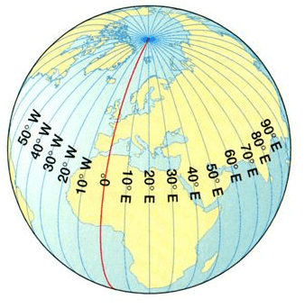
Identify the red line in the picture. Options are as follows
- a)Latitudes
- b)Grids
- c)Prime Meridian
- d)Longitude
Correct answer is option 'C'. Can you explain this answer?
Identify the red line in the picture. Options are as follows
a)
Latitudes
b)
Grids
c)
Prime Meridian
d)
Longitude
|
|
Priya Menon answered |
Vertical lines on the globe are Known as longitudes. But zero degree longitude is called as prime meridian. Prime meridian is also a longitude. Here, 0 degree prime meridian is shown only as an example. Prime meridian is also known as longitude but vice versa of it is not possible. For example, Prime meridian is always a longitude but every longitude is not prime meridian. In this picture all longitudes are shown.
So, the correct answer is Option C.
So, the correct answer is Option C.
The Prime Meridian passes through:
- a)Greenwood
- b)Greenfield
- c)Greenshire
- d)Greenwich
Correct answer is option 'D'. Can you explain this answer?
The Prime Meridian passes through:
a)
Greenwood
b)
Greenfield
c)
Greenshire
d)
Greenwich

|
Rajveer Choudhury answered |
The prime meridian is also known as the Greenwich Meridian. In a geographical coordinate system, the Greenwich Meridian (or prime meridian) is the 0° line of longitude from which we measure 180° to the west and 180° to the east. Most coordinate systems define a zero line at the equator that runs east-west.
Equator is an- a)Imaginary rectangular line
- b)Imaginary circular line
- c)Imaginary straight line
- d)Imaginary triangular line
Correct answer is option 'B'. Can you explain this answer?
Equator is an
a)
Imaginary rectangular line
b)
Imaginary circular line
c)
Imaginary straight line
d)
Imaginary triangular line
|
|
Neha Joshi answered |
The Equator is an imaginary line around the middle of the Earth. It is halfway between the North and South Poles, and divides the Earth into the Northern and Southern Hemispheres. The Equator is the invisible line that runs around the center of the Earth at 0 degrees latitude.
The frigid zone lies near- a)The Poles
- b)The Tropic of Capricorn
- c)The Equator
- d)The Tropic of Cancer
Correct answer is option 'A'. Can you explain this answer?
The frigid zone lies near
a)
The Poles
b)
The Tropic of Capricorn
c)
The Equator
d)
The Tropic of Cancer

|
Rajeev Sen answered |
The Frigid Zone lies near the Poles. The climate in the Polar Regions is very cold that is why the area is known as the Frigid Zone. It includes the area around the North Pole and the South Pole.
Describe the shape of the Earth?- a)A sphere which bulges at the poles and flattens at the centre
- b)A sphere which flattens at the poles and bulges at the centre
- c)A sphere which bulges at the poles and at the centre
- d)A perfect sphere
Correct answer is option 'B'. Can you explain this answer?
Describe the shape of the Earth?
a)
A sphere which bulges at the poles and flattens at the centre
b)
A sphere which flattens at the poles and bulges at the centre
c)
A sphere which bulges at the poles and at the centre
d)
A perfect sphere
|
|
Priya Menon answered |
Fig: Shape of the Earth
The Standard Meridian of India is- a)88°30' E
- b)86°30' E
- c)82°30' E
- d)84°30' E
Correct answer is option 'C'. Can you explain this answer?
The Standard Meridian of India is
a)
88°30' E
b)
86°30' E
c)
82°30' E
d)
84°30' E
|
|
Malavika Sengupta answered |
° E
b) 82° E
c) 90° E
d) 76° E
c) 90° E
b) 82° E
c) 90° E
d) 76° E
c) 90° E
Two end point of the axis are called- a)Grid
- b)Poles
- c)Equator
- d)Axis
Correct answer is option 'B'. Can you explain this answer?
Two end point of the axis are called
a)
Grid
b)
Poles
c)
Equator
d)
Axis
|
|
Pooja Choudhury answered |
The two end points on the axis of rotation are called the poles. To the north is the North Pole, and to the south is the South Pole.
The line which cut the world into north and south latitude- a)Equator
- b)Latitude
- c)Longitude
- d)Prime meridian
Correct answer is option 'A'. Can you explain this answer?
The line which cut the world into north and south latitude
a)
Equator
b)
Latitude
c)
Longitude
d)
Prime meridian

|
Arjun Desai answered |
Latitude is based on an imaginary line that circles Earth halfway between the north and south poles. This line is called the and it divides Earth into northern and southern hemispheres. A hemisphere is one half of a sphere. is a distance in degrees north or south of the equator, which is 0degree.
What is the latitude of the Antarctic Circle?- a)23½° S
- b)66½° S
- c)23½° N
- d)66½° N
Correct answer is option 'B'. Can you explain this answer?
a)
23½° S
b)
66½° S
c)
23½° N
d)
66½° N

|
Torcia Education answered |
The Antarctic Circle is located at 66½° S latitude. It marks the region south of which there is at least one day per year when the sun does not rise and at least one day when it does not set.
What is the latitude value of the Tropic of Capricorn?- a)23½° N
- b)66½° S
- c)23½° S
- d)66½° N
Correct answer is option 'C'. Can you explain this answer?
a)
23½° N
b)
66½° S
c)
23½° S
d)
66½° N

|
Keystone Instructors answered |
The Tropic of Capricorn is located at 23½° S latitude. It is one of the five major circles of latitude that mark maps of the Earth and signifies the most southerly position at which the sun can be directly overhead.
What are latitude and longitude lines?
- a)Thick and thin line that divide the Earth
- b)An imaginary line that divide the Earth
- c)A real line that divides the Earth
- d)Long and short line that divide the Earth
Correct answer is option 'B'. Can you explain this answer?
What are latitude and longitude lines?
a)
Thick and thin line that divide the Earth
b)
An imaginary line that divide the Earth
c)
A real line that divides the Earth
d)
Long and short line that divide the Earth
|
|
Aruna Singh answered |
Latitude and longitude lines form an imaginary grid over the entire surface of Earth. Latitude is based on an imaginary line that circles Earth halfway between the north and south poles. This line is called the equator and it divides Earth into northern and southern hemispheres. Latitude is a distance in degrees north or south of the equator. Longitude is a distance in degrees east or west of the Prime Meridian.
The Arctic Circle is located in the- a)Western hemisphere
- b)Southern hemisphere
- c)Northern hemisphere
- d)Eastern hemisphere
Correct answer is option 'C'. Can you explain this answer?
The Arctic Circle is located in the
a)
Western hemisphere
b)
Southern hemisphere
c)
Northern hemisphere
d)
Eastern hemisphere

|
Divey Sethi answered |
The Arctic Circle is a region on Earth that is marked as one of the five major circles of latitude on maps of our planet. It is located between the Arctic to its north and the Northern Temperate Zone to its south. Its counterpart in the Southern Hemisphere is known as the Antarctic Circle.
The distance between the longitude- a)Decreases towards Poles
- b)Increases towards Poles
- c)Decreases towards North Poles only
- d)Decreases towards South Poles only
Correct answer is option 'A'. Can you explain this answer?
The distance between the longitude
a)
Decreases towards Poles
b)
Increases towards Poles
c)
Decreases towards North Poles only
d)
Decreases towards South Poles only
|
|
Alok Verma answered |
Unlike latitude, the distance between degrees of longitude varies greatly depending upon your location on the planet. They are farthest apart at the equator and converge at the poles. A degree of longitude is widest at the equator with a distance of 69.172 miles (111.321 kilometers).
The Northern most end of the axis is _____- a)South Pole
- b)Northern Hemisphere
- c)Southern Hemisphere
- d)North Pole
Correct answer is option 'D'. Can you explain this answer?
The Northern most end of the axis is _____
a)
South Pole
b)
Northern Hemisphere
c)
Southern Hemisphere
d)
North Pole
|
|
Amit Kumar answered |
The Northern tip and the Southern tip of the axis are called the North Pole and the South Pole. The Earth rotates or spins on its axis. The axis is an imaginary straight line which passes through the North Pole, the centre of the Earth and the South Pole. The Earth's axial tilt is about 23.5 degrees.
IST stands for- a)Internal Specific Time
- b)Internal Standard Temperate
- c)Indian Standard Time
- d)Indian Specific Time
Correct answer is option 'C'. Can you explain this answer?
IST stands for
a)
Internal Specific Time
b)
Internal Standard Temperate
c)
Indian Standard Time
d)
Indian Specific Time

|
Janhavi Dey answered |
Indian Standard Time (IST) is the time observed throughout India, with a timeoffset of UTC+05:30. India does not observe daylight saving time (DST) or other seasonal adjustments. In military and aviation time IST is designated E* ("Echo-Star").
______ measure the distance north and south of the Equator
- a)Primary
- b)Longitude
- c)Standard
- d)Latitude
Correct answer is option 'D'. Can you explain this answer?
______ measure the distance north and south of the Equator
a)
Primary
b)
Longitude
c)
Standard
d)
Latitude
|
|
Rahul Choudhury answered |
Latitude measures the distance north or south of the equator. Lines of latitude, also called parallels, are imaginary lines that divide the Earth.
Which zone has moderate temperatures?- a)Torrid Zone
- b)Temperate Zone
- c)Frigid Zone
- d)Equatorial Zone
Correct answer is option 'B'. Can you explain this answer?
a)
Torrid Zone
b)
Temperate Zone
c)
Frigid Zone
d)
Equatorial Zone
|
|
Keystone Instructors answered |
The Temperate Zones have moderate temperatures and experience distinct seasonal changes. They lie between the Tropic of Cancer and the Arctic Circle in the Northern Hemisphere and between the Tropic of Capricorn and the Antarctic Circle in the Southern Hemisphere.
Which zones are bounded by the Arctic Circle and the Tropic of Cancer in the Northern Hemisphere?
- a)Torrid Zone
- b)Temperate Zone
- c)Frigid Zone
- d)Equatorial Zone
Correct answer is option 'B'. Can you explain this answer?
Which zones are bounded by the Arctic Circle and the Tropic of Cancer in the Northern Hemisphere?
a)
Torrid Zone
b)
Temperate Zone
c)
Frigid Zone
d)
Equatorial Zone
|
|
Keystone Instructors answered |
The Temperate Zone lies between the Arctic Circle and the Tropic of Cancer in the Northern Hemisphere. This zone experiences moderate temperatures and distinct seasonal changes.
What is the imaginary line on the globe that divides it into two equal parts?- a)North Pole
- b)Equator
- c)South Pole
- d)Tropic of Cancer
Correct answer is option 'B'. Can you explain this answer?
What is the imaginary line on the globe that divides it into two equal parts?
a)
North Pole
b)
Equator
c)
South Pole
d)
Tropic of Cancer
|
|
Torcia Education answered |
- The imaginary line that divides the globe into two equal parts is called the Equator. It's like the middle line on a circle.
- The Equator helps us know which part of the Earth we are in - whether it's the Northern Hemisphere or the Southern Hemisphere.
- Remember, it's like the Earth's waistband!
The 0 degree Meridian is also known asa)Prime Standardb)Prime Meridianc)Equator Primed)GreenfieldCorrect answer is option 'B'. Can you explain this answer?
|
|
Varun Kapoor answered |
This is why prime meridian is also known as the Greenwich Meridian. In a geographical coordinate system, the Greenwich Meridian (or prime meridian) is the 0 degree line of longitude from which we measure 180 degree to the west and 180 degree to the east. Most coordinate systems define a zero line at the equator that runs east-west.
Days and nights are equal throughout the globe when the sun is above:- a)Poles
- b)Equator
- c)Tropic of Cancer
- d)Tropic of Capricorn
Correct answer is option 'B'. Can you explain this answer?
Days and nights are equal throughout the globe when the sun is above:
a)
Poles
b)
Equator
c)
Tropic of Cancer
d)
Tropic of Capricorn
|
|
Meera Menon answered |
Explanation:
When the sun is directly above the equator, it creates a line that divides the Earth into two equal parts. This is known as the equinox. During the equinox, the days and nights are equal throughout the globe.
Reasons:
This happens because of the following reasons:
1. Angle of Incidence: When the sun is directly above the equator, the angle of incidence of the sun's rays is perpendicular to the Earth's surface. This means that the sunlight is falling directly on the equator, creating equal amounts of daylight and darkness.
2. Earth's Rotation: The Earth rotates on its axis, which creates the cycle of day and night. During the equinox, the Earth's axis is perpendicular to the sun's rays, which means that the daylight and darkness are spread equally across the globe.
Other Options:
The other options in the question are incorrect because:
A) Poles: The poles experience periods of complete darkness and complete daylight, depending on the season.
C) Tropic of Cancer: The Tropic of Cancer is located at 23.5 degrees north of the equator. When the sun is directly above the Tropic of Cancer, it is the summer solstice in the northern hemisphere and the winter solstice in the southern hemisphere. This means that the daylight and darkness are not equal across the globe.
D) Tropic of Capricorn: The Tropic of Capricorn is located at 23.5 degrees south of the equator. When the sun is directly above the Tropic of Capricorn, it is the winter solstice in the northern hemisphere and the summer solstice in the southern hemisphere. This means that the daylight and darkness are not equal across the globe.
This marks the location of the equator on Earth- a)20 degree
- b)90 degree
- c)180 degree
- d)0 degree
Correct answer is option 'D'. Can you explain this answer?
This marks the location of the equator on Earth
a)
20 degree
b)
90 degree
c)
180 degree
d)
0 degree
|
|
Sagarika Menon answered |
The equator divides the earth into the Northern Hemisphere and the Southern Hemisphere is marks the location of 0 degrees latitude. The equator marks the locations on earth that are equidistance from the North and South Poles. Theequator crosses 78.7% water and 21.3% land and is about 24,901 miles (40,075 km) long.
State whether the following statement is True or False:The area between the Tropic of Cancer and the Tropic of Capricorn receives the maximum heat and is called the Frigid Zone.- a)True
- b)False
Correct answer is option 'B'. Can you explain this answer?
State whether the following statement is True or False:
The area between the Tropic of Cancer and the Tropic of Capricorn receives the maximum heat and is called the Frigid Zone.
a)
True
b)
False
|
|
Torcia Education answered |
The area between the Tropic of Cancer and the Tropic of Capricorn receives the maximum heat and is called the Torrid Zone, not the Frigid Zone. The Frigid Zones are the areas closer to the poles which are very cold because the sun's rays there are always slanting and provide less heat.
Why are the regions called Frigid Zones very cold?- a)Because they are located far from the equator
- b)Because they have no sunlight throughout the year
- c)Because the sun's rays are always slanting and provide less heat
- d)Because they are covered with snow and ice
Correct answer is option 'C'. Can you explain this answer?
Why are the regions called Frigid Zones very cold?
a)
Because they are located far from the equator
b)
Because they have no sunlight throughout the year
c)
Because the sun's rays are always slanting and provide less heat
d)
Because they are covered with snow and ice
|
|
Torcia Education answered |
Areas between the Arctic Circle and the North Pole in the Northern Hemisphere are very cold. The same applies to the region between the Antarctic Circle and the South Pole in the Southern Hemisphere. The extreme cold in these regions is due to the fact that the sun remains low on the horizon, resulting in slanting rays that provide minimal heat. These frigid zones are characterized by consistently low temperatures.
Chapter doubts & questions for Globe: Latitudes and Longitudes - Class 6 All Subjects (Old NCERT) 2025 is part of Class 6 exam preparation. The chapters have been prepared according to the Class 6 exam syllabus. The Chapter doubts & questions, notes, tests & MCQs are made for Class 6 2025 Exam. Find important definitions, questions, notes, meanings, examples, exercises, MCQs and online tests here.
Chapter doubts & questions of Globe: Latitudes and Longitudes - Class 6 All Subjects (Old NCERT) in English & Hindi are available as part of Class 6 exam.
Download more important topics, notes, lectures and mock test series for Class 6 Exam by signing up for free.
Class 6 All Subjects (Old NCERT)
297 videos|1066 docs|204 tests
|
|
© EduRev
|
Education Revolution
|


|


Signup to see your scores
go up
within 7 days!
within 7 days!
Takes less than 10 seconds to signup