


All Exams >
Civil Engineering (CE) >
6 Months Preparation for GATE Civil Engg >
All Questions
All questions of Fundamental Concepts of Surveying for Civil Engineering (CE) Exam
Which one of the following surveys is employed for collecting sufficient data in connection with sewage disposal and water supply works?- a)Topographic survey
- b)Cadastral survey
- c)Geodetic survey
- d)Cross-sectioning and profile levelling
Correct answer is option 'D'. Can you explain this answer?
Which one of the following surveys is employed for collecting sufficient data in connection with sewage disposal and water supply works?
a)
Topographic survey
b)
Cadastral survey
c)
Geodetic survey
d)
Cross-sectioning and profile levelling

|
Ankit Joshi answered |
Cadastral Survey: to establish a boundary of properties for legal use
Topographical Survey: Surveys which are carried out to depict mountains, rivers, water bodies, wooded areas and other cultural details
Geodetic Survey: Considering earth’s curvature. Usually used when area to be surveyed is greater than 260 sq.km
Cross-Sectioning and Profile Levelling- Collecting sufficient data in connection with sewage disposal and water supply works
City Survey: survey of city
Guide Map Survey: For showing relief by contours and spot heights.

The representative fraction 1/2500 means that the scale 1 cm is equal to- a)0.25 m
- b)2,5 m
- c)25 m
- d)2.5 km
Correct answer is option 'C'. Can you explain this answer?
The representative fraction 1/2500 means that the scale 1 cm is equal to
a)
0.25 m
b)
2,5 m
c)
25 m
d)
2.5 km

|
Priyanka Shah answered |
1/2500 means
1 cm = 2500 cm
∴ 1 cm = 25 m
Geodetic surveying is different from plane surveying because of- a)the curvature of earth
- b)the large difference of elevations between various points
- c)coverage of very large area
- d)undulations of very large area
Correct answer is option 'A'. Can you explain this answer?
Geodetic surveying is different from plane surveying because of
a)
the curvature of earth
b)
the large difference of elevations between various points
c)
coverage of very large area
d)
undulations of very large area
|
|
Ameya Roy answered |
Geodetic Surveying:
Geodetic surveying is a type of surveying that takes into account the curvature of the earth. It is used to accurately measure large distances and areas, such as the size and shape of the earth, the location of continents, and the distances between them.
Difference from Plane Surveying:
Plane surveying, on the other hand, assumes that the earth is flat and is used to measure smaller distances and areas. The main difference between geodetic and plane surveying is the curvature of the earth.
Importance of the Curvature of the Earth:
The curvature of the earth is an important factor in geodetic surveying because it affects the accuracy of measurements over large distances. When measuring over a long distance, the curvature of the earth must be taken into account to ensure that the measurements are accurate. Failure to take the curvature of the earth into account can result in significant errors in measurements.
Applications of Geodetic Surveying:
Geodetic surveying is used in a wide range of applications, including:
- Mapping of large areas such as continents, countries, and regions
- Navigation and positioning of ships, airplanes, and other vehicles
- Determination of the size and shape of the earth
- Monitoring of changes in the earth's surface, such as tectonic movements, sea level changes, and the melting of ice caps
- Planning and construction of large-scale engineering projects such as bridges, tunnels, and dams
Conclusion:
In conclusion, geodetic surveying is different from plane surveying because it takes into account the curvature of the earth, which is an important factor in accurately measuring large distances and areas. It is used in a wide range of applications, from mapping large areas to the planning and construction of large-scale engineering projects.
Theory of probability is applied to
- a)both accidental and cumulative errors
- b)cumulative errors only
- c)accidental errors only
- d)none of the above
Correct answer is option 'C'. Can you explain this answer?
Theory of probability is applied to
a)
both accidental and cumulative errors
b)
cumulative errors only
c)
accidental errors only
d)
none of the above
|
|
Lavanya Menon answered |
Laws of accidental errors follow the probability law, which is having a definite law for accidental error occurrence. It defines the errors and helps in expressing them in the form of equations.
Offsets are
- a)parallel lines erected from chain lines
- b)lateral measurements made with respect to main survey lines
- c)taken to avoid unnecessary walking between stations
- d)measurements which are not made at right angles to the chain line
Correct answer is option 'B'. Can you explain this answer?
Offsets are
a)
parallel lines erected from chain lines
b)
lateral measurements made with respect to main survey lines
c)
taken to avoid unnecessary walking between stations
d)
measurements which are not made at right angles to the chain line
|
|
Sankar Dasgupta answered |
In surveying, offsets are lateral measurements taken from the main survey line (baseline) to plot the position of different points or objects. These measurements are generally taken at a right angle to the main survey lines, helping to create an accurate representation of the area being surveyed.
For example, if a surveyor is measuring a piece of land with a building on it, they would first establish the main survey line (baseline) and then measure the distance from the line to the corners of the building. These lateral measurements are called offsets.
Offsets allow surveyors to accurately map the location of various features on a piece of land, such as buildings, fences, or natural features like streams or trees. This information is then used to create maps, plan construction projects, or establish property boundaries.
For a well-conditional triangle, no angle should be less than- a)2CP
- b)30°
- c)45°
- d)6CF
Correct answer is option 'B'. Can you explain this answer?
For a well-conditional triangle, no angle should be less than
a)
2CP
b)
30°
c)
45°
d)
6CF
|
|
Raghavendra Goyal answered |
For a well-conditioned triangle all the angles must lie in the range of 300-1200.
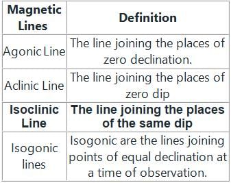
The lines joining points of equal dip are called- a)Aclinic lines
- b)Isogonic lines
- c)Agonic lines
- d)Isoclinic lines
Correct answer is option 'D'. Can you explain this answer?
The lines joining points of equal dip are called
a)
Aclinic lines
b)
Isogonic lines
c)
Agonic lines
d)
Isoclinic lines
|
|
Tanvi Shah answered |
Dip
- It is the inclination of the magnetic needle with the horizontal. The dip is zero at the equator and the needle will remain horizontal.
- At a place near 70° north latitude and 96° west longitude, the dip will be 90°. This area is called the magnetic north pole. Similarly, near the south magnetic pole, the dip is 90°.
Declination
- It is the angle between the magnetic and geographic meridians or the angle in the horizontal plane between magnetic north and true north.
Explanation
By an equation how can you define a cycloid?- a)y = a(1-sin α)
- b)x = a(α – cos α)
- c)x = a(α – sin α)
- d)x = a(1- sin α)
Correct answer is option 'C'. Can you explain this answer?
By an equation how can you define a cycloid?
a)
y = a(1-sin α)
b)
x = a(α – cos α)
c)
x = a(α – sin α)
d)
x = a(1- sin α)
|
|
Aarav Kulkarni answered |
(x/a)
b)y = a(1-cos(x/a))
c)y = a(1+sin(x/a))
d)y = a(1+cos(x/a))
b)y = a(1-cos(x/a))
c)y = a(1+sin(x/a))
d)y = a(1+cos(x/a))
Parabolic curves is not used in ________- a)Arches
- b)Bridges
- c)Sound reflectors
- d)Boring
Correct answer is option 'D'. Can you explain this answer?
Parabolic curves is not used in ________
a)
Arches
b)
Bridges
c)
Sound reflectors
d)
Boring
|
|
Tanvi Shah answered |
Mostly used in construction and also for converging or diverging light since radiation often needs to be concentrated at one point (e.g. radio telescopes, pay TV dishes, solar radiation collectors) also to be transmitted from a single point into a wide parallel beam (e.g. headlight reflectors). Boring uses single point cutting tools which are straight vertical shaped.
The vertical angle between the longitudinal axis of a suspended magnetic needle and the horizontal line is referred as:- a)Azimuth
- b)Declination
- c)Dip
- d)Bearing
Correct answer is option 'C'. Can you explain this answer?
The vertical angle between the longitudinal axis of a suspended magnetic needle and the horizontal line is referred as:
a)
Azimuth
b)
Declination
c)
Dip
d)
Bearing
|
|
Tanvi Shah answered |
Dip
- It is the inclination of the magnetic needle with the horizontal. The dip is zero at the equator and the needle will remain horizontal.
- At a place near 70° north latitude and 96° west longitude, the dip will be 90°. This area is called the magnetic north pole. Similarly, near the south magnetic pole, the dip is 90°.
Declination
- It is the angle between the magnetic and geographic meridians or the angle in the horizontal plane between magnetic north and true north.
Different magnetic lines are as follows
Important Points
Isobar or pressure bulb
It is a stress contour or a line that connects all points below the ground surface at which the vertical pressure is the same.
The difference in length between the arc and the subtended chord on the earth's surface is taken as 500mm in:- a)18.2 km
- b)91 km
- c)100 km
- d)600 km
Correct answer is option 'D'. Can you explain this answer?
The difference in length between the arc and the subtended chord on the earth's surface is taken as 500mm in:
a)
18.2 km
b)
91 km
c)
100 km
d)
600 km
|
|
Saptarshi Khanna answered |
Arc and Subtended Chord on Earth's Surface
To understand the difference in length between the arc and the subtended chord on the Earth's surface, let's break down the problem and analyze it step by step.
Given:
Length difference between the arc and the subtended chord = 500 mm
We need to find the distance on the Earth's surface that corresponds to this length difference.
Understanding the Problem:
When a chord is drawn between two points on the Earth's surface, it subtends an arc on the Earth's surface. The arc is the curved distance between the two points, while the chord is the straight line distance between the two points.
The difference between the arc and the chord occurs due to the curvature of the Earth's surface. As the Earth is approximately spherical, the arc will be longer than the chord.
Solution:
To find the distance on the Earth's surface corresponding to the given length difference, we need to use the formula for the difference between the arc and the chord length:
Length difference = (R - R × cosθ) - 2R × sin²(θ/2)
- R is the radius of the Earth
- θ is the central angle between the two points in radians
We know that the length difference is given as 500 mm. We can choose suitable values for R and θ to solve the equation.
Calculations:
Let's assume the radius of the Earth, R = 6371 km (approximately).
Now, we need to find the central angle (θ) corresponding to the given length difference.
Since the length difference is given as 500 mm, we need to convert it to kilometers.
500 mm = 500/1000 km = 0.5 km
Substituting the values in the formula:
0.5 km = (6371 km - 6371 km × cosθ) - 2 × 6371 km × sin²(θ/2)
Simplifying the equation and solving for θ, we get:
θ ≈ 0.009042 radians
Now, we can find the distance on the Earth's surface corresponding to this central angle using the formula:
Distance = R × θ
Distance = 6371 km × 0.009042 ≈ 57.64 km
Therefore, the correct answer is option 'D' which corresponds to a distance of 600 km.
Conclusion:
The difference in length between the arc and the subtended chord on the Earth's surface is approximately 500 mm, which corresponds to a distance of approximately 600 km on the Earth's surface.
In which direction latitude of the line is positive?- a)North
- b)South
- c)East
- d)West
Correct answer is option 'A'. Can you explain this answer?
In which direction latitude of the line is positive?
a)
North
b)
South
c)
East
d)
West
|
|
Tanvi Shah answered |
The latitude of the line is positive when measured northward. It is termed as northing.
In which direction latitude of the line is negative?- a)North
- b)South
- c)East
- d)West
Correct answer is option 'B'. Can you explain this answer?
In which direction latitude of the line is negative?
a)
North
b)
South
c)
East
d)
West
|
|
Akshat Datta answered |
Direction of Negative Latitude
Latitude is the angular distance of a location north or south of the equator. Negative latitude values indicate locations in the Southern Hemisphere, while positive latitude values indicate locations in the Northern Hemisphere.
Explanation
- North: When moving north from the equator, the latitude values increase and become positive.
- South: When moving south from the equator, the latitude values decrease and become negative. Therefore, the correct answer is option B) South.
- East and West: Latitude lines do not have a direct relationship with east or west directions. East and west directions are related to longitude, not latitude.
Therefore, to determine the direction in which latitude becomes negative, one must move south from the equator. This understanding is crucial for accurately determining the location of a point on Earth's surface using latitude coordinates.
Determine the radius of curve if it is designated as 3° curve on a 30m arc.- a)573 m
- b)1.57 m
- c)1719.7 m
- d)570 m
Correct answer is option 'A'. Can you explain this answer?
Determine the radius of curve if it is designated as 3° curve on a 30m arc.
a)
573 m
b)
1.57 m
c)
1719.7 m
d)
570 m
|
|
Tanvi Shah answered |
Simple circular curve:
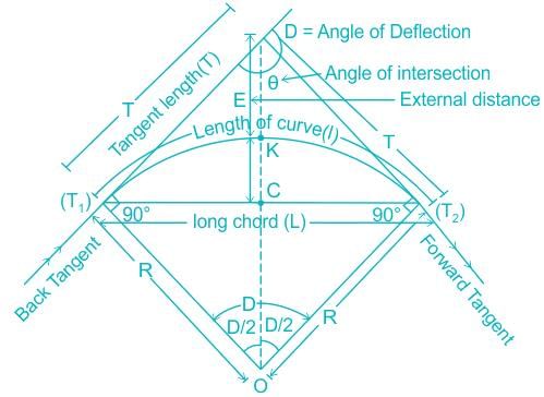
Explanation:
The length of the curve (l):
the length of curve T1 K T2 is given by
Given: l = 30 m, D = 3°
R = 572.957 m
Additional Information
The degree of curve is given as,
Explanation:
The length of the curve (l):
the length of curve T1 K T2 is given by
Given: l = 30 m, D = 3°
R = 572.957 m
Additional Information
The degree of curve is given as,
- For 20 m chain length,

- For 30 m chain length,

Where,
Da = degree of curve and R = radius of the curve
Different parameters of Simple circular curve:
Tangent Length (T) = R tan (D/2)
Length of long Chord (L) = 2R sin (D/2)
Mid-ordinate (M) = R {1 - cos (D/2)}
External distance (E) = R {sec(D/2) - 1}
Da = degree of curve and R = radius of the curve
Different parameters of Simple circular curve:
Tangent Length (T) = R tan (D/2)
Length of long Chord (L) = 2R sin (D/2)
Mid-ordinate (M) = R {1 - cos (D/2)}
External distance (E) = R {sec(D/2) - 1}
The difference between the most probable value of a quantity and its observer value is- a)true error
- b)weighted observations
- c)conditional error
- d)residual error
Correct answer is option 'D'. Can you explain this answer?
The difference between the most probable value of a quantity and its observer value is
a)
true error
b)
weighted observations
c)
conditional error
d)
residual error
|
|
Madhurima Banerjee answered |
True Error = Actual Value-Observed Value
Weighted Observations=Observations taken with proportion to any quantity like an area
Conditional Error= Error occurring due to certain conditions prevailing. Like temperature error.
Residual Error = Most Probable Value- Observed Value
Weighted Observations=Observations taken with proportion to any quantity like an area
Conditional Error= Error occurring due to certain conditions prevailing. Like temperature error.
Residual Error = Most Probable Value- Observed Value
How many methods are used in levelling?- a)3
- b)2
- c)4
- d)5
Correct answer is option 'B'. Can you explain this answer?
How many methods are used in levelling?
a)
3
b)
2
c)
4
d)
5
|
|
Abhay Banerjee answered |
In levelling, there are generally two main methods used to determine the difference in elevation between points. These methods are known as height of collimation method and rise and fall method. Let's discuss each method in detail.
1. Height of Collimation Method:
The height of collimation method is a simple and widely used levelling technique. It involves setting up a level instrument at a known benchmark and taking readings on a staff held at the point whose elevation is to be determined. The method is based on the principle that the line of sight through the telescope of the level remains horizontal, even if the instrument is not perfectly leveled.
The steps involved in the height of collimation method are as follows:
a) Set up the level instrument at a known benchmark and take a reading on the staff held at that point. This reading is the benchmark reading (BM).
b) Move the level instrument to the desired point and take a reading on the staff held at that point. This reading is the backsight (BS) or foresight (FS) depending on whether the instrument is set up before or after the desired point.
c) Calculate the difference in elevation between the benchmark and the desired point by subtracting the BS from the BM or the FS from the BM.
2. Rise and Fall Method:
The rise and fall method is another commonly used levelling technique, especially when there are multiple points to be leveled. This method involves taking readings at each point and recording the rise or fall in elevation between consecutive points.
The steps involved in the rise and fall method are as follows:
a) Set up the level instrument at a suitable point and take a reading on the staff held at that point. This reading is the backsight (BS).
b) Move the level instrument to the next point and take a reading on the staff held at that point. This reading is the foresight (FS).
c) Calculate the rise or fall in elevation between the two points by subtracting the FS from the BS.
d) Record the rise or fall value and repeat the process for the subsequent points.
The rise and fall method allows for a continuous calculation of elevation differences between points, making it useful for determining the profile of a terrain or establishing contours.
In conclusion, the two main methods used in levelling are the height of collimation method and the rise and fall method. Both methods have their advantages and are used depending on the specific requirements of the levelling task.
Which of the below is used up to a range of 100km?- a)Infrared
- b)Microwave
- c)Visible range
- d)Ultra-violet
Correct answer is option 'B'. Can you explain this answer?
Which of the below is used up to a range of 100km?
a)
Infrared
b)
Microwave
c)
Visible range
d)
Ultra-violet
|
|
Tanvi Shah answered |
Microwave EDMs can be used up to a range of 100km to locate the object. Infrared is a commonly used type, with a range up to 3km.
Which of the following are Traverse networks advantages?- a)Less reconnaissance and organization needed
- b)Scale error does not add up as the traverse is performed
- c)Traverse networks are free of the strength of figure considerations that happen in triangular systems
- d)All of the above
Correct answer is option 'D'. Can you explain this answer?
Which of the following are Traverse networks advantages?
a)
Less reconnaissance and organization needed
b)
Scale error does not add up as the traverse is performed
c)
Traverse networks are free of the strength of figure considerations that happen in triangular systems
d)
All of the above
|
|
Meghana Desai answered |
Overview of Traverse Networks Advantages
Traverse networks offer several significant advantages in surveying and civil engineering. Understanding these benefits helps in choosing the right method for data collection and analysis.
Less Reconnaissance and Organization Needed
- Traverse networks require minimal preliminary reconnaissance.
- They allow surveyors to efficiently gather data without extensive planning.
- This reduces the time and resources spent on the initial organization.
Scale Error Does Not Accumulate
- In traverse networks, scale errors are localized.
- Each segment of the traverse is calculated independently, minimizing cumulative error.
- This leads to increased accuracy in measurements over large distances.
Freedom from Strength of Figure Considerations
- Unlike triangular systems, traverse networks are less affected by structural stability.
- They do not rely on the strength of figure for accuracy, which can lead to complications in triangulation.
- This flexibility simplifies the surveying process and enhances reliability.
Conclusion
The advantages of traverse networks make them a preferred choice in civil engineering applications. The combination of reduced reconnaissance needs, minimized scale errors, and independence from strength of figure considerations contributes to their overall effectiveness in accurate land surveying. Hence, the correct answer is indeed option 'D', as all the mentioned advantages are valid.
How many types of traverse?- a)2
- b)3
- c)4
- d)5
Correct answer is option 'A'. Can you explain this answer?
How many types of traverse?
a)
2
b)
3
c)
4
d)
5

|
Bijoy Mehra answered |
There are two types of traverse commonly used in civil engineering: open traverse and closed traverse.
Open Traverse:
An open traverse is a type of traverse where the starting and ending points are not the same. It is used to determine the coordinates and distances between a known point and the unknown points along the traverse line. In an open traverse, the starting point is known, and the direction is established by using a theodolite or a compass. From the starting point, the surveyor measures the angles and distances to each subsequent point along the traverse line. The coordinates of each point are then calculated using trigonometry or coordinate geometry.
Closed Traverse:
A closed traverse, on the other hand, is a type of traverse where the starting and ending points are the same. It is used to determine the accuracy of the measurements and calculations in a survey. In a closed traverse, the surveyor starts at a known point and measures the angles and distances to each subsequent point along the traverse line. However, instead of ending at a different point, the surveyor returns to the starting point. The coordinates of each point are calculated using the measurements and the known coordinates of the starting point. The closure error, which is the difference between the calculated coordinates and the known coordinates of the starting point, is used to assess the accuracy of the survey.
The choice of whether to use an open traverse or a closed traverse depends on the specific requirements of the survey. Open traverses are commonly used when the objective is to establish the coordinates and distances between known and unknown points. Closed traverses, on the other hand, are used to verify the accuracy of the survey measurements and calculations. Both types of traverses are important tools in civil engineering for establishing accurate survey networks and determining the positions of points on the ground.
In _________ levelling, the first and last point are at a far distance.- a)Fly
- b)Differential
- c)Profile
- d)Reciprocal
Correct answer is option 'B'. Can you explain this answer?
In _________ levelling, the first and last point are at a far distance.
a)
Fly
b)
Differential
c)
Profile
d)
Reciprocal
|
|
Garima Kulkarni answered |
In Differential levelling, the first and last point are at a far distance.
Explanation:
Differential levelling is a widely used technique in civil engineering for determining the difference in height between two points. It is commonly used for surveying and construction projects to establish accurate elevation measurements.
When performing differential levelling, the first and last point are typically selected at a relatively far distance from each other. This is done to ensure that the levelling instrument remains within its range and can accurately measure the height difference between the two points.
Advantages of Differential Levelling:
1. Accuracy: Differential levelling is known for its high level of accuracy in determining height differences. It allows for precise measurements, which are crucial in construction and surveying projects.
2. Long-distance measurements: By selecting the first and last point at a far distance, differential levelling enables the measurement of height differences over a large area. This is particularly useful when determining the slope or gradient of a terrain.
3. Elimination of errors: Differential levelling eliminates systematic errors that may occur due to changes in atmospheric conditions. By taking multiple readings at different points along the levelling line, any errors caused by temperature, pressure, or humidity changes can be minimized or eliminated.
4. Versatility: Differential levelling can be applied in various terrains and environments, making it a versatile technique. It can be used in both flat and uneven surfaces, allowing engineers and surveyors to obtain accurate elevation data in different project settings.
5. Cost-effective: Differential levelling is a cost-effective method compared to other techniques used for measuring height differences. It requires relatively simple equipment and can be performed by skilled personnel without the need for specialized technology.
Conclusion:
In summary, the first and last point in differential levelling are chosen at a far distance to ensure accurate measurements and cover a large area. This technique offers high precision, versatility, and cost-effectiveness, making it a valuable tool in civil engineering projects.
Which of the following is NOT a permanent adjustment for a theodolite?- a)Elimination of parallax
- b)Adjustment of the vertical circle index
- c)Adjustment of the telescope
- d)Adjustment of the horizonal plate level
Correct answer is option 'A'. Can you explain this answer?
Which of the following is NOT a permanent adjustment for a theodolite?
a)
Elimination of parallax
b)
Adjustment of the vertical circle index
c)
Adjustment of the telescope
d)
Adjustment of the horizonal plate level
|
|
Tanvi Shah answered |
Permanent adjustments:
The permanent adjustment are made to establish the fixed relationships between the fundamental lines of the instrument, and once made, they last for long time. The following are the permanent adjustments in transit Theodolites:
The permanent adjustment are made to establish the fixed relationships between the fundamental lines of the instrument, and once made, they last for long time. The following are the permanent adjustments in transit Theodolites:
- Adjustment of the Horizontal Plate Levels.
- Collimation Adjustment
- Horizontal Axis Adjustment
- Adjustment of the Telescope Level or the Altitude level.
- Vertical Circle Index Adjustment
Temporary adjustments
The temporary adjustments are made at each set up of the instrument before starting taking observations with the instrument. The following are the temporary adjustments in transit Theodolite:
The temporary adjustments are made at each set up of the instrument before starting taking observations with the instrument. The following are the temporary adjustments in transit Theodolite:
- Setting up the Theodolite over the station.
- Levelling up the Theodolite.
- Elimination of the parallel.
- Focussing.
∴ From above Elimination of parallax is not permanent adjustment of theodolite.
Which one of the following closely represent the shape of the earth?- a)Spheroid
- b)Ellipsoid
- c)Oblate spheroid
- d)Prolate spheroid
Correct answer is option 'C'. Can you explain this answer?
Which one of the following closely represent the shape of the earth?
a)
Spheroid
b)
Ellipsoid
c)
Oblate spheroid
d)
Prolate spheroid
|
|
Jay Sharma answered |
The actual shape of the earth is an oblate spheroid, it is an ellipsoid of revolution, flattened at the poles and bulging at the equator. The-length of the polar axis is about 12, 113.168 km and that of equatorial axis is about 12, 756.602 km. Thus polar axis is shorter than the equatorial axis by about 43.434 km.
How methods are there for prolongation of a straight line?- a)1
- b)2
- c)3
- d)4
Correct answer is option 'C'. Can you explain this answer?
How methods are there for prolongation of a straight line?
a)
1
b)
2
c)
3
d)
4
|
|
Tanvi Shah answered |
There are three methods of prolonging a straight line. Those are named as first method, second method and third method.
_________ is a method in the field of surveying to establish control networks- a)Compass
- b)Traverse
- c)Chain
- d)Levelling
Correct answer is option 'B'. Can you explain this answer?
_________ is a method in the field of surveying to establish control networks
a)
Compass
b)
Traverse
c)
Chain
d)
Levelling
|
|
Bibek Mehra answered |
Traverse is a method used in surveying to establish control networks. It is an essential technique used to determine the relative positions of points on the Earth's surface. The primary objective of a traverse is to measure the angles and distances between survey control points, which are then used to create a network of control points.
Definition of Traverse:
Traverse is a series of connected survey lines used to establish control points. It involves measuring angles and distances between control points, which are typically marked by survey monuments or other physical markers. The traverse network is then used as a reference for carrying out additional surveys or for mapping purposes.
Steps in Conducting a Traverse:
1. Selection of Control Points: The first step in conducting a traverse is to select control points that are well-distributed throughout the survey area. These control points should be easily accessible and have a stable foundation for long-term use.
2. Angle Measurements: The next step is to measure the angles between the control points using a theodolite or a total station. The instrument is set up over a control point, and the angles are measured by sighting to the next control point.
3. Distance Measurements: After measuring the angles, the distances between control points are measured using a variety of methods, such as electronic distance measurement (EDM) instruments or tape measures. The accuracy of the distance measurement is crucial for the overall accuracy of the traverse network.
4. Calculations: Once all the angles and distances have been measured, they are used to calculate the coordinates of the control points. This involves applying trigonometric and geometric calculations to determine the precise positions of the control points in relation to each other.
5. Adjustment: After the initial calculations, a process called adjustment is conducted to improve the accuracy of the traverse network. This involves redistributing the errors in the angles and distances to minimize the overall error in the network.
6. Verification: Finally, the accuracy of the traverse network is verified by re-measuring some of the angles and distances. This helps ensure that the network meets the required accuracy standards.
Importance of Traverse:
Traverse networks are crucial in surveying as they provide a framework for other surveying activities. They serve as a reference for establishing control points, mapping the terrain, and conducting other types of surveys. Without a reliable traverse network, it would be challenging to accurately determine the positions of points on the Earth's surface.
Surveys which are carried out to depict mountains, rivers, water bodies, wooded areas and other cultural details, are known as- a)cadastral surveys
- b)city surveys
- c)topographical surveys
- d)guide map surveys
Correct answer is option 'C'. Can you explain this answer?
Surveys which are carried out to depict mountains, rivers, water bodies, wooded areas and other cultural details, are known as
a)
cadastral surveys
b)
city surveys
c)
topographical surveys
d)
guide map surveys
|
|
Harshad Iyer answered |
Cadastral Survey: to establish a boundary of properties for legal use.
City Survey: survey of city
Topographical Survey: Surveys which are carried out to depict mountains, rivers, water bodies, wooded areas and other cultural details
Guide Map Survey: For showing relief by contours and spot heights.
City Survey: survey of city
Topographical Survey: Surveys which are carried out to depict mountains, rivers, water bodies, wooded areas and other cultural details
Guide Map Survey: For showing relief by contours and spot heights.
The principle of ‘working from whole to part’ is used in surveying because- a)plotting becomes easy
- b)survey work can be completed quickly
- c)accumulation of errors is prevented
- d)All of the above
Correct answer is option 'C'. Can you explain this answer?
The principle of ‘working from whole to part’ is used in surveying because
a)
plotting becomes easy
b)
survey work can be completed quickly
c)
accumulation of errors is prevented
d)
All of the above
|
|
Athira Pillai answered |
Working from whole to part prevent the accumulation of cumulative errors due to multiple check points and controlled points already set up from which a part can be plotted accurately without depending on the previous plotted point.
If the radius of curve is 380m, what is its degree designation on 20m arc?- a)0.0526
- b)0.00526
- c)3.01
- d)0.00091
Correct answer is option 'C'. Can you explain this answer?
If the radius of curve is 380m, what is its degree designation on 20m arc?
a)
0.0526
b)
0.00526
c)
3.01
d)
0.00091
|
|
Mahesh Nair answered |
To determine the degree designation of a curve on a given arc, we need to use the formula:
Degree = (Arc Length / Radius) * 180 / π
Given:
Radius of curve = 380 m
Arc length = 20 m
Calculating the degree designation:
Degree = (20 / 380) * 180 / π
Simplifying further:
Degree = (1 / 19) * 180 / π
To find the value of Degree, we need to calculate the value of π.
π (pi) is a mathematical constant that represents the ratio of the circumference of a circle to its diameter. It is approximately equal to 3.14159.
Calculating the value of π:
π ≈ 3.14159
Substituting the value of π into the equation:
Degree = (1 / 19) * 180 / 3.14159
Simplifying further:
Degree ≈ 9.47368
Rounding off to two decimal places, the degree designation on the 20 m arc of a curve with a radius of 380 m is approximately 9.47 degrees.
The correct answer is option C) 3.01.
Note: The provided answer options seem to be incorrect or mislabeled. The calculated degree designation does not match any of the given options.
Which unit in total station processes data collected?- a)Data collector
- b)EDM
- c)Storage system
- d)Microprocessor
Correct answer is option 'D'. Can you explain this answer?
Which unit in total station processes data collected?
a)
Data collector
b)
EDM
c)
Storage system
d)
Microprocessor
|
|
Sakshi Basak answered |
Data processing in a total station is performed by the microprocessor unit. The microprocessor is a central processing unit (CPU) that carries out instructions and performs calculations based on the data collected by the total station. It serves as the brain of the instrument, enabling it to process and analyze the collected data efficiently and accurately.
The microprocessor unit in a total station is responsible for several key functions, including:
1. Data Collection: The microprocessor unit receives input from various sensors in the total station, such as the EDM (electronic distance measurement) sensor and the angle measurement sensor. It collects raw data from these sensors, including distance measurements, angles, and other relevant information.
2. Data Calculation: Once the raw data is collected, the microprocessor performs calculations to process the data and obtain useful information. For example, it can calculate the coordinates of surveyed points based on distance and angle measurements. It can also perform trigonometric calculations to determine distances, elevations, and other geometric properties.
3. Data Storage: The microprocessor unit is responsible for storing the processed data in the total station's memory. This allows the user to access and retrieve the data at a later time. The storage system may include internal memory within the total station or external storage devices such as memory cards or USB drives.
4. Data Display: The microprocessor unit controls the display screen of the total station, presenting the processed data to the user in a clear and organized manner. It can show measurements, coordinates, and other information in real time, allowing the user to make informed decisions during the surveying process.
Overall, the microprocessor unit plays a crucial role in the operation of a total station by processing the collected data, performing calculations, storing the data, and presenting it to the user. It enables efficient and accurate surveying by automating complex calculations and reducing human error.
Which of the following is the INCORRECT correction to be applied while determining the difference in elevation between two points, when the observations are from only one point?- a)Axis signal correction
- b)Correction for sag
- c)Correction for curvature
- d)Correction for refraction
Correct answer is option 'B'. Can you explain this answer?
Which of the following is the INCORRECT correction to be applied while determining the difference in elevation between two points, when the observations are from only one point?
a)
Axis signal correction
b)
Correction for sag
c)
Correction for curvature
d)
Correction for refraction
|
|
Tanvi Shah answered |
The following corrections are to be applied while determining the difference in elevation between two points when the observations are from only one point:
- Axis signal correction
- In order to observe the points from the theodolite station, signals of appropriate heights are erected at the points to be observed. The signal may or may not be the same height as that of the instrument.
- If the height of the signal is not the same as that of the height of the instrument axis above the station, a correction known as the axis signal correction or eye and object correction is applied
- Correction for curvature
- Earth has actually a curved surface which is assumed to be a level surface for simplification in the surveying. So the level line between the stations is not horizontal in real conditions but the line of sight by the leveling instrument is horizontal.
- The vertical distance between the horizontal line and the level line denotes the effect of the curvature of the earth. The correction applied to counter this error is curvature correction
- Correction for refraction
- The rays of light passing through the atmosphere of different densities bend down. It results in this type of correction.
- The effect of refraction is 1/7th time the curvature correction but is of the opposite nature. Hence the correction for refraction is additive to the staff reading.
Hence, Correction for sag is the incorrect correction to be applied while determining the difference in elevation between two points, when the observations are from only one point.
_______ is the sum of meridian distance of two ends of line. - a)Direction Meridian Distance
- b)Double Meridian Direction
- c)Double Meridian Distance
- d)Doubt Meridian Distance
Correct answer is option 'C'. Can you explain this answer?
_______ is the sum of meridian distance of two ends of line.
a)
Direction Meridian Distance
b)
Double Meridian Direction
c)
Double Meridian Distance
d)
Doubt Meridian Distance
|
|
Tanvi Shah answered |
The double meridian distance of a line is equal to the sum of the meridian distances of the two extremities, which is useful for the determination of the required area of the plot.
- The sum of the meridian distances of the ends of a survey line.
- In practice, assuming a closed traverse with the meridian of reference passing through the initial station, the double meridian distance (DMD) of the first course (line) is equal to the departure of that course; the double meridian distance of each succeeding course (line) is equal to the double meridian distance of the preceding course, plus the departure of the preceding course, plus the departure of the course itself.
- If the DMD of each course is multiplied by the latitude of the corresponding course, double areas are obtained, from which the area of the tract can be obtained.
- By a strictly analogous procedure, double parallel distances (DPD) can be computed, using the latitudes of the successive courses instead of departures, and using an east-west line as the reference parallel.
To run a straight line between two points, when both ends are inter visible. We establish intermediate points through ________- a)line of sight
- b)balancing
- c)using random line
- d)back sight
Correct answer is option 'A'. Can you explain this answer?
To run a straight line between two points, when both ends are inter visible. We establish intermediate points through ________
a)
line of sight
b)
balancing
c)
using random line
d)
back sight
|
|
Tanvi Shah answered |
Set instrument at A and take sight on B. Establish intermediate points C, D, E etc. In the line of sight. It possible only in case both ends are inter visible.
In a road embankment work, the reduced level of formation bed at Zero m chainage is 107 m. The road is supposed to have a downward gradient of 1 in 100. Determine the reduced level of formation bed at 1000 m chainage - a)107 m
- b)97 m
- c)100 m
- d)117 m
Correct answer is option 'B'. Can you explain this answer?
In a road embankment work, the reduced level of formation bed at Zero m chainage is 107 m. The road is supposed to have a downward gradient of 1 in 100. Determine the reduced level of formation bed at 1000 m chainage
a)
107 m
b)
97 m
c)
100 m
d)
117 m
|
|
Gowri Sharma answered |
Given information:
- Reduced level of formation bed at Zero m chainage = 107 m
- Downward gradient of the road = 1 in 100
To determine:
- Reduced level of formation bed at 1000 m chainage
Explanation:
The downward gradient of 1 in 100 means that for every 100 units of horizontal distance, there is a 1 unit decrease in vertical distance.
We can use this information to calculate the change in reduced level over a given distance.
Step 1: Calculate the change in reduced level per unit distance.
Change in reduced level per unit distance = Gradient × Distance = 1/100 × 1000 = 10 m
This means that for every 1000 m of horizontal distance, there is a decrease of 10 m in vertical distance.
Step 2: Calculate the reduced level at 1000 m chainage.
Reduced level at 1000 m chainage = Reduced level at Zero m chainage - Change in reduced level
= 107 m - 10 m
= 97 m
Therefore, the reduced level of the formation bed at 1000 m chainage is 97 m (Option B).
How many types of levelling are there?- a)3
- b)2
- c)4
- d)5
Correct answer is option 'C'. Can you explain this answer?
How many types of levelling are there?
a)
3
b)
2
c)
4
d)
5
|
|
Sanaya Sengupta answered |
The correct answer is option 'C', which states that there are four types of leveling. Levelling is a technique used in civil engineering and surveying to determine the height or elevation of different points relative to a reference point or benchmark. It is an essential process in various construction and engineering projects to ensure accuracy and precision in measurements.
There are four types of leveling commonly used in civil engineering:
1. Differential Leveling:
Differential leveling is the most basic and commonly used type of leveling. It involves measuring the vertical distance between two points using a leveling instrument called a level. A level consists of a telescope mounted on a tripod, which is used to sight a leveling rod held vertically at the desired point. By comparing the readings on the leveling rod at the different points, the height difference between the two points can be determined.
2. Trigonometric Leveling:
Trigonometric leveling is a more advanced method that uses trigonometry to calculate the height difference between two points. It involves measuring the horizontal distance between the two points and the vertical angle between the line connecting the points and the horizontal plane. Using these measurements and trigonometric functions, the height difference can be calculated without physically measuring the vertical distance.
3. Barometric Leveling:
Barometric leveling is a technique that uses atmospheric pressure to determine height differences. It involves measuring the atmospheric pressure at two different points and then using the barometric formula to calculate the height difference. This method is often used in areas where traditional leveling is difficult, such as mountainous regions or areas with limited accessibility.
4. Digital Leveling:
Digital leveling is a modern method that uses electronic instruments to measure height differences. These instruments, known as digital levels or automatic levels, use electronic sensors and digital displays to provide accurate and precise measurements. Digital leveling is faster and more efficient than traditional leveling methods, as it eliminates the need for manual reading and recording of measurements.
In conclusion, there are four types of leveling commonly used in civil engineering: differential leveling, trigonometric leveling, barometric leveling, and digital leveling. Each method has its own advantages and disadvantages, and the choice of method depends on the specific requirements of the project and the available resources.
Theory of errors and adjustments deals with minimizing the effects of- a)instrumental errors
- b)mistakes
- c)systematic errors
- d)personal and accidental errors
Correct answer is option 'D'. Can you explain this answer?
Theory of errors and adjustments deals with minimizing the effects of
a)
instrumental errors
b)
mistakes
c)
systematic errors
d)
personal and accidental errors
|
|
Divya Mehta answered |
Systematic or cumulative errors which occurs from well understood causes can be reduced by adopting suitable methods. It follows some definite mathematical or physical iaw and a correction can be-determined and applied.
Accidental errors are those which remain after mistakes and systematic errors have been eliminated and are caused by a combination of reasons beyond the ability of the observer to control. Personal errors arise from the limitations of the human senses such as sight, touch and hearing. Both accidental and personal error represent the limit of precision in the determination of a value. They obey the law of probability and therefore theory of errors and adjustments applies to them.
Accidental errors are those which remain after mistakes and systematic errors have been eliminated and are caused by a combination of reasons beyond the ability of the observer to control. Personal errors arise from the limitations of the human senses such as sight, touch and hearing. Both accidental and personal error represent the limit of precision in the determination of a value. They obey the law of probability and therefore theory of errors and adjustments applies to them.
A plot of land 60 m x 20 m is measured by a steel tape. If the standard error of length and width measurements is taken as ±1 cm, then the standard error of the area of the plot would be- a)±0.1414 m2
- b)±0.566 m2
- c)±0.632 m2
- d)±0.8484 m2
Correct answer is option 'C'. Can you explain this answer?
A plot of land 60 m x 20 m is measured by a steel tape. If the standard error of length and width measurements is taken as ±1 cm, then the standard error of the area of the plot would be
a)
±0.1414 m2
b)
±0.566 m2
c)
±0.632 m2
d)
±0.8484 m2
|
|
Bhargavi Sengupta answered |
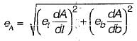
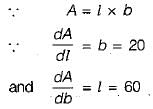
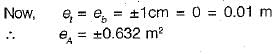
Standard error of area is given by,
Two straight lines deflect through an angle of 60°, the radius of a curve joining the two straight lines is 600 m. The length of the long chord and mid ordinate (in m) of the curve respectively are- a)80.4, 600.0
- b)600.0, 80.4
- c)600.0, 39.89
- d)49.89, 300.00
Correct answer is option 'B'. Can you explain this answer?
Two straight lines deflect through an angle of 60°, the radius of a curve joining the two straight lines is 600 m. The length of the long chord and mid ordinate (in m) of the curve respectively are
a)
80.4, 600.0
b)
600.0, 80.4
c)
600.0, 39.89
d)
49.89, 300.00
|
|
Anand Kumar answered |
The angle between two straight lines is defined as the smallest angle between them. Therefore, if two straight lines deflect through an angle of 60 degrees, it means the angle between them is 60 degrees.
The suitable contour interval for a map with scale 1 : 10000 is- a)2 m
- b)5 m
- c)10 m
- d)20 m
Correct answer is option 'A'. Can you explain this answer?
The suitable contour interval for a map with scale 1 : 10000 is
a)
2 m
b)
5 m
c)
10 m
d)
20 m
|
|
Tanishq Rane answered |
The suitable contour interval for a map depends on the scale of the map and the level of detail required. In this case, the map scale is given as 1:10000.
Understanding Scale:
The scale of a map indicates the ratio of distances on the map to the actual distances on the ground. For example, a scale of 1:10000 means that one unit of measurement on the map represents 10000 units of measurement on the ground.
Importance of Contour Intervals:
Contour intervals are the vertical distance between contour lines on a topographic map. Contour lines connect points of equal elevation, allowing us to visualize the shape and relief of the land. The contour interval determines the level of detail shown on the map.
Choosing the Suitable Contour Interval:
To choose the suitable contour interval for a map, we need to consider the scale of the map and the level of detail required.
Scale of 1:10000:
A scale of 1:10000 represents a relatively large area with a high level of detail. It means that one unit on the map represents 10000 units on the ground.
Suitable Contour Interval:
For a map with a scale of 1:10000, a contour interval of 2 meters would be suitable.
- A contour interval of 2 meters provides a high level of detail, allowing for accurate representation of the landforms and terrain features.
- With a smaller contour interval, the map will show more contour lines, resulting in a more detailed depiction of the topography.
- This level of detail is appropriate for many applications, such as urban planning, engineering design, and land development.
Other Options:
The other options provided in the question are 5 m, 10 m, and 20 m.
- A contour interval of 5 meters would provide less detail compared to 2 meters. It would result in fewer contour lines on the map, leading to a less accurate representation of the terrain.
- Contour intervals of 10 meters and 20 meters would provide even less detail, suitable for larger-scale maps or general overview purposes. However, they would not be suitable for a map with a scale of 1:10000, which requires a higher level of detail.
Therefore, option 'A' with a contour interval of 2 m is the correct answer for a map with a scale of 1:10000.
The error due to bad ranging is- a)cumulative; positive
- b)cumulative; negative
- c)compensating
- d)cumulative; positive or negative
Correct answer is option 'A'. Can you explain this answer?
The error due to bad ranging is
a)
cumulative; positive
b)
cumulative; negative
c)
compensating
d)
cumulative; positive or negative
|
|
Prashanth Mehra answered |
Cumulative Errors occurring in same direction and thus, they aggregate to make a considerable amount of error.
Positive cumulative errors Non Horizontality, sag, bad ranging.
Positive/ Negative cumulative errors Erroneous length of chain, temperature variation.
Positive cumulative errors Non Horizontality, sag, bad ranging.
Positive/ Negative cumulative errors Erroneous length of chain, temperature variation.
To set the Total Station at a point, temporary adjustments have to be made. The temporary adjustments to be made periodically are:- a)Centering and Leveling
- b)Fixing and Leveling
- c)Leveling and Sighting
- d)Centering and Sighting
Correct answer is option 'A'. Can you explain this answer?
To set the Total Station at a point, temporary adjustments have to be made. The temporary adjustments to be made periodically are:
a)
Centering and Leveling
b)
Fixing and Leveling
c)
Leveling and Sighting
d)
Centering and Sighting
|
|
Tanvi Shah answered |
Temporary Adjustments of Total station
Adjustments which required to be made at every instrument station before making any observation. It can be done by following three procedures,
Adjustments which required to be made at every instrument station before making any observation. It can be done by following three procedures,
- Centering the Total station over the station.
- Levelling the Total station.
- Elimination of parallax.
Centering the Total station over the station
- This includes the Centering of the Total station over the ground mark and also approximate levelling with the help of Tripod legs.
- While centering, it is necessary to ensure the approximate levelness; otherwise, the centering will be disturbed when subsequent Levelling of the instrument is done. It can be done either using a plumb-bob or laser plummet.
Levelling the Total station
Accurate Levelling is done with the help of plate levels using levelling screws. Here the Vertical axis (plumb line)of the Total station is made truly vertical.
Accurate Levelling is done with the help of plate levels using levelling screws. Here the Vertical axis (plumb line)of the Total station is made truly vertical.
- Align the bubble parallel to two-foot screws and bring it to the center by turning both screws same direction.
- Align the bubble with the remaining foot screw (turn 90°) and bring it to the center by rotating it
- Repeat the process till the bubble remain centered in any direction. Principle of reversibility.
Elimination of parallax
- It is done by focusing the eyepiece for the distinct vision of crosshairs and focusing on the object to bring the image of the object in the plane of crosshairs. Accurate bisection and sighting are difficult when there is Parallax.
- Hold a white paper in front of the objective or sight the telescope towards the sky. Move the eyepiece in or out till the crosshairs are seen as sharp and distinct.
- Can be checked by moving the eye slowly to one side. If there is no parallax the image and the crosshairs will appears still.
The magnetic bearing of line AB is 132° 45'. If the magnetic declination is 10° 20'W, the true bearing of the line AB will be- a)122° 25'
- b)143° 5'
- c)121° 25'
- d)122° 30'
Correct answer is option 'A'. Can you explain this answer?
The magnetic bearing of line AB is 132° 45'. If the magnetic declination is 10° 20'W, the true bearing of the line AB will be
a)
122° 25'
b)
143° 5'
c)
121° 25'
d)
122° 30'

|
Isha Bajaj answered |
The magnetic bearing of line AB is 132 degrees.
A circle of radius 7 m has a standard error of 0.02 m on the radius. The standard error of its area is- a)0.04 m2
- b)0:14 m2
- c)0.28 m2
- d)0.88 m2
Correct answer is option 'D'. Can you explain this answer?
A circle of radius 7 m has a standard error of 0.02 m on the radius. The standard error of its area is
a)
0.04 m2
b)
0:14 m2
c)
0.28 m2
d)
0.88 m2
|
|
Divya Kulkarni answered |
Area of circle
A = πr2
∴ dA/dr = 2πr
Let standard error in radius be er,
∴ Standard error in area,
A = πr2
∴ dA/dr = 2πr
Let standard error in radius be er,
∴ Standard error in area,
A total station is a combination of:- a)EDM and Theodolite
- b)Compass and EDM
- c)Electronic Theodolite and EDM
- d)EDM and electronic Compass
Correct answer is option 'C'. Can you explain this answer?
A total station is a combination of:
a)
EDM and Theodolite
b)
Compass and EDM
c)
Electronic Theodolite and EDM
d)
EDM and electronic Compass
|
|
Divya Mehta answered |
A total station is a commonly used instrument in surveying and engineering applications. It combines the functionality of an electronic theodolite and an electronic distance measurement (EDM) device. Let's break down the components and their functions to understand why option 'C' is the correct answer.
1. Electronic Theodolite:
The electronic theodolite is a precision instrument used for measuring horizontal and vertical angles. It consists of a telescope mounted on a rotating base, which allows it to measure angles accurately. The theodolite also includes a vertical circle and a horizontal circle, which are used to read the angles. The electronic theodolite provides precise angular measurements required for surveying and engineering tasks.
2. Electronic Distance Measurement (EDM):
The EDM is a device used to measure distances accurately. It utilizes electromagnetic waves or laser technology to determine the distance between the total station and a target point. The EDM emits a beam or wave towards the target, and the time taken for the beam to reflect back to the instrument is measured. By knowing the speed of the wave or beam, the distance can be calculated accurately. The EDM eliminates the need for manual measuring tapes or chains, increasing the efficiency and accuracy of distance measurements.
Combining the Two Components:
By integrating the electronic theodolite and the EDM, a total station provides a comprehensive solution for surveying and engineering tasks. The electronic theodolite measures the angles, while the EDM measures the distances. The total station combines these measurements to calculate the precise coordinates of points in a survey. It can determine not only the distances and angles but also the heights and positions of objects.
The total station typically includes an internal computer and software that allows the user to enter data, store measurements, and perform various calculations. It can also be connected to an external computer for more advanced processing and analysis.
In conclusion, a total station is a combination of an electronic theodolite and an EDM. It offers the ability to measure angles and distances accurately, providing essential data for surveying and engineering tasks.
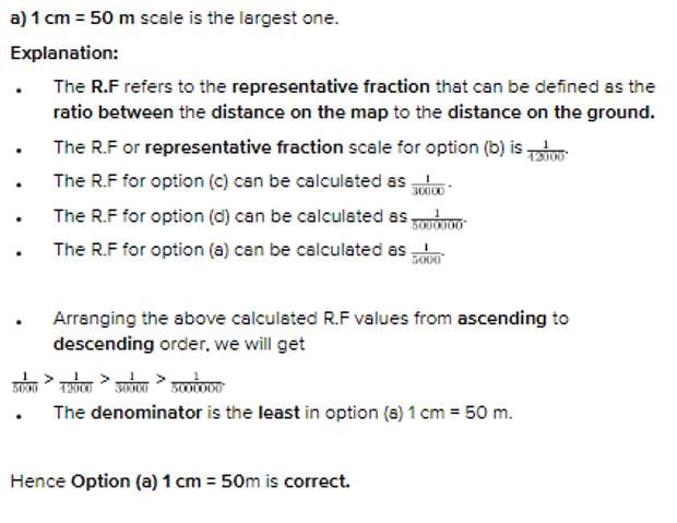
What is a systematic error?
- a)It is a compensating error
- b)It is a cumulative error that occurs under the same conditions
- c)It is an error that occurs because of change of temperature
- d)It is an error that occurs due to faulty adjustments of the instruments.
Correct answer is option 'B'. Can you explain this answer?
What is a systematic error?
a)
It is a compensating error
b)
It is a cumulative error that occurs under the same conditions
c)
It is an error that occurs because of change of temperature
d)
It is an error that occurs due to faulty adjustments of the instruments.
|
|
Sankar Rane answered |
Systematic Error
Systematic error is a type of error that occurs consistently in the same direction in a series of measurements. It arises due to a flaw in the measuring instrument or a mistake in the experimental setup. Unlike random error, systematic error cannot be reduced by increasing the number of measurements.
Explanation
Option B is the correct answer because a systematic error occurs due to a change in temperature. Systematic error is also known as bias error, and it can arise due to many factors such as instrument calibration, environmental conditions, and human error. In this case, change in temperature can cause the instrument to expand or contract, leading to inaccurate readings. For example, a thermometer that is calibrated at room temperature may give incorrect readings when used in a hot or cold environment.
Other Causes of Systematic Error
Apart from change in temperature, there are other causes of systematic error, which include:
1. Faulty adjustments of the instruments - If the instruments used in an experiment are not calibrated correctly, they can produce inaccurate readings.
2. Human error - Human error can occur when an experimenter consistently makes the same mistake while conducting an experiment.
3. Instrument drift - Over time, instruments can become less accurate due to wear and tear or aging, leading to systematic error.
4. Environmental conditions - Changes in humidity, pressure, or other environmental conditions can affect the accuracy of an instrument.
Conclusion
In conclusion, systematic error is a type of error that occurs consistently in the same direction in a series of measurements. It arises due to a flaw in the measuring instrument or a mistake in the experimental setup. Option B is the correct answer as a change in temperature is one of the causes of systematic error.
The degree of the curve is an angle subtended at the centre by a chord of length ________ and the degree of a curve with radius 688 m will be equal to _________.- a)30 m; 2.5°
- b)30 m; 3°
- c)20 m; 2°
- d)20 m; 2.5°
Correct answer is option 'A'. Can you explain this answer?
The degree of the curve is an angle subtended at the centre by a chord of length ________ and the degree of a curve with radius 688 m will be equal to _________.
a)
30 m; 2.5°
b)
30 m; 3°
c)
20 m; 2°
d)
20 m; 2.5°
|
|
Tanvi Shah answered |
(a) if the length of the chord is 20 m

Where R = Radius of the curve in m
Dº = Degree of curve
(b) If the chord length is 30 m

Calculation:
Given data:
Curve radius (R) = 688 m
Chord length (L) =?
Degree of the curve (Dº) =?
Let the length of the chord is 20
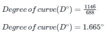
Degree of curve 1.665º not given an option
Let the length of the chord is 30
Where R = Radius of the curve in m
Dº = Degree of curve
(b) If the chord length is 30 m
Calculation:
Given data:
Curve radius (R) = 688 m
Chord length (L) =?
Degree of the curve (Dº) =?
Let the length of the chord is 20
Degree of curve 1.665º not given an option
Let the length of the chord is 30
Total station is used for- a)Remote object height determination
- b)Establishing horizontal control
- c)Establishing vertical control
- d)All of the above
Correct answer is option 'D'. Can you explain this answer?
Total station is used for
a)
Remote object height determination
b)
Establishing horizontal control
c)
Establishing vertical control
d)
All of the above
|
|
Sakshi Basak answered |
Total Station Usage
A total station is a modern surveying instrument that integrates electronic theodolite and electronic distance measurement (EDM) technology. It is widely used in the field of civil engineering for various purposes. This response aims to explain the three main applications of a total station.
One of the primary uses of a total station is remote object height determination. This refers to the ability of the instrument to measure the height of objects that are not directly accessible or visible to the surveyor. By using the horizontal and vertical angles measured by the theodolite, as well as the distance obtained through the EDM, the total station can calculate the height of objects such as buildings, trees, or power lines. This information is crucial for tasks such as designing infrastructure, assessing clearance requirements, or planning construction projects.
Another important application of a total station is the establishment of horizontal control points. Horizontal control refers to the establishment of a network of known points, typically marked with survey monuments, that serve as reference points for future surveys. These control points help ensure accurate and consistent measurements throughout a project site. The total station is used to measure the angles and distances between control points, allowing for the creation of a precise horizontal control network. This is vital for tasks such as mapping, land development, and alignment of structures.
Total stations are also used for establishing vertical control. Vertical control involves determining the elevations of points on the Earth's surface relative to a reference datum, such as mean sea level. By measuring the vertical angles and distances to known points of established elevation, the total station can calculate the elevation of other points. This information is essential for tasks such as contour mapping, drainage design, and construction layout.
In summary, a total station is a versatile instrument used in civil engineering for various purposes. It is utilized for remote object height determination, establishing horizontal control, and establishing vertical control. These applications play a crucial role in accurate surveying, mapping, and design, ultimately contributing to the successful execution of civil engineering projects.
Introduction
A total station is a modern surveying instrument that integrates electronic theodolite and electronic distance measurement (EDM) technology. It is widely used in the field of civil engineering for various purposes. This response aims to explain the three main applications of a total station.
Remote Object Height Determination
One of the primary uses of a total station is remote object height determination. This refers to the ability of the instrument to measure the height of objects that are not directly accessible or visible to the surveyor. By using the horizontal and vertical angles measured by the theodolite, as well as the distance obtained through the EDM, the total station can calculate the height of objects such as buildings, trees, or power lines. This information is crucial for tasks such as designing infrastructure, assessing clearance requirements, or planning construction projects.
Establishing Horizontal Control
Another important application of a total station is the establishment of horizontal control points. Horizontal control refers to the establishment of a network of known points, typically marked with survey monuments, that serve as reference points for future surveys. These control points help ensure accurate and consistent measurements throughout a project site. The total station is used to measure the angles and distances between control points, allowing for the creation of a precise horizontal control network. This is vital for tasks such as mapping, land development, and alignment of structures.
Establishing Vertical Control
Total stations are also used for establishing vertical control. Vertical control involves determining the elevations of points on the Earth's surface relative to a reference datum, such as mean sea level. By measuring the vertical angles and distances to known points of established elevation, the total station can calculate the elevation of other points. This information is essential for tasks such as contour mapping, drainage design, and construction layout.
Conclusion
In summary, a total station is a versatile instrument used in civil engineering for various purposes. It is utilized for remote object height determination, establishing horizontal control, and establishing vertical control. These applications play a crucial role in accurate surveying, mapping, and design, ultimately contributing to the successful execution of civil engineering projects.
The directions of survey lines are fixed by angular measurements and not by forming a network of triangles. This statement is true for which type of surveying?- a)Compass surveying
- b)Triangulation surveying
- c)Plane surveying
- d)None of these
Correct answer is option 'A'. Can you explain this answer?
The directions of survey lines are fixed by angular measurements and not by forming a network of triangles. This statement is true for which type of surveying?
a)
Compass surveying
b)
Triangulation surveying
c)
Plane surveying
d)
None of these
|
|
Tanvi Shah answered |
Principle of Compass Surveying :
- In compass traversing the directions of survey lines are fixed by angular measurements and not by forming a network of triangles.
- A compass survey is one in which the traverse work consists of a series of lines the lengths and directions of which are measured with a chain or a tape, and with an angular instrument respectively.
A traverse may be classified as:
Closed traverse (link traverse):
Closed traverse (link traverse):
- A closed traverse is a traverse in which the sides of a traverse form a closed polygon.
Open traverse (loop traverse):
- An open traverse is a traverse in which the sides of the traverse do not form a closed polygon.
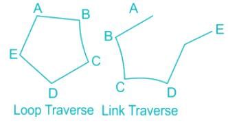

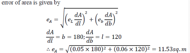
The bubble in a total station is centralised using:- a)Tripod
- b)Levelling screw
- c)Tangent screw
- d)Foot screw
Correct answer is option 'A'. Can you explain this answer?
The bubble in a total station is centralised using:
a)
Tripod
b)
Levelling screw
c)
Tangent screw
d)
Foot screw

|
Aniket Ghoshal answered |
Centralizing the bubble in a total station using a tripod
Introduction:
In surveying and construction, a total station is a highly precise instrument that combines the functions of a theodolite (angle measurement) and an electronic distance meter (EDM). One of the key components of a total station is the bubble, which is used to ensure that the instrument is leveled properly. The bubble must be centralized in order to ensure accurate measurements.
Importance of centralizing the bubble:
Centralizing the bubble is crucial for accurate measurements because it ensures that the instrument is level and aligned properly. If the bubble is not centralized, it can result in errors in both horizontal and vertical measurements. Therefore, it is essential to properly centralize the bubble before using a total station.
Process of centralizing the bubble using a tripod:
To centralize the bubble in a total station, the following steps are typically followed:
1. Set up the tripod: The first step is to set up the tripod on a stable and level surface. The tripod legs should be extended to the desired height and the tripod head should be securely fastened.
2. Attach the total station: The total station is then attached to the tripod head using the mounting screw. It should be securely fastened to ensure stability during measurements.
3. Roughly level the instrument: The leveling screws on the tripod head are used to roughly level the instrument. These screws allow for adjustments in the horizontal and vertical directions. The goal at this stage is to get the instrument close to level but not perfectly level.
4. Adjust the foot screws: The foot screws located at the base of the tripod are then adjusted to fine-tune the leveling of the instrument. These screws allow for very precise adjustments in the horizontal and vertical directions. The goal is to level the instrument as accurately as possible.
5. Check the bubble: Once the instrument is leveled using the foot screws, the bubble is checked. The bubble should be centered between the two reference lines on the circular level vial. If the bubble is off-center, the foot screws are adjusted again until the bubble is perfectly centered.
6. Repeat the process: The process of leveling and centralizing the bubble may need to be repeated multiple times to achieve the desired accuracy. This is particularly important when working on uneven or sloping terrain.
Conclusion:
Centralizing the bubble in a total station is a critical step in ensuring accurate measurements. By following the proper procedures and using a tripod, the bubble can be centralized to achieve precise leveling. This allows for reliable and consistent measurements in surveying and construction applications.
When the point is within the circle, the curve is called an ________- a)Inferior trochoid
- b)Superior trochoid
- c)Inscribed trochoid
- d)Superior trochiod
Correct answer is option 'A'. Can you explain this answer?
When the point is within the circle, the curve is called an ________
a)
Inferior trochoid
b)
Superior trochoid
c)
Inscribed trochoid
d)
Superior trochiod
|
|
Tanvi Shah answered |
Trochoid is a curve generated by a point fixed to a circle, within or outside its circumference, as the circle rolls along a straight line. The curve generated below shows us the inferior trochoid.
Chapter doubts & questions for Fundamental Concepts of Surveying - 6 Months Preparation for GATE Civil Engg 2025 is part of Civil Engineering (CE) exam preparation. The chapters have been prepared according to the Civil Engineering (CE) exam syllabus. The Chapter doubts & questions, notes, tests & MCQs are made for Civil Engineering (CE) 2025 Exam. Find important definitions, questions, notes, meanings, examples, exercises, MCQs and online tests here.
Chapter doubts & questions of Fundamental Concepts of Surveying - 6 Months Preparation for GATE Civil Engg in English & Hindi are available as part of Civil Engineering (CE) exam.
Download more important topics, notes, lectures and mock test series for Civil Engineering (CE) Exam by signing up for free.
6 Months Preparation for GATE Civil Engg
488 videos|1261 docs|878 tests
|
|
© EduRev
|
Education Revolution
|


|


Signup to see your scores
go up within 7 days!
Access 1000+ FREE Docs, Videos and Tests
Takes less than 10 seconds to signup