


All Exams >
Civil Engineering (CE) >
Irrigation Engineering >
All Questions
All questions of Methods of Irrigation for Civil Engineering (CE) Exam
With the increase in supplied irrigation water, the yield of crops- a)increases continuously
- b)decreases continuously
- c)increases up to a certain limit, and then becomes constant
- d)increases up to a certain limit, and then decreases
Correct answer is option 'D'. Can you explain this answer?
With the increase in supplied irrigation water, the yield of crops
a)
increases continuously
b)
decreases continuously
c)
increases up to a certain limit, and then becomes constant
d)
increases up to a certain limit, and then decreases

|
Shounak Saini answered |
Initially, when supply increases plants will get adequate water depth for their growth but ager certain limit water will cause water logging thus, degrading the growth of plants.

Permanent wilting point moisture content for a crop represents the- a)hygroscopic water
- b)capillary water
- c)field capacity water
- d)water of adhesion
Correct answer is option 'A'. Can you explain this answer?
Permanent wilting point moisture content for a crop represents the
a)
hygroscopic water
b)
capillary water
c)
field capacity water
d)
water of adhesion
|
|
Sanvi Kapoor answered |
Permanent wilting point is the point beyond which the roots of plant cannot access water. It is the hygroscopic water.
Useful soil moisture for plant growth is capillary water.
Useful soil moisture for plant growth is capillary water.
Irrigation frequency is a function of- a)crop only
- b)soil, crop and climate
- c)soil, crop, climate and fertilizer
- d)soil and climate
Correct answer is option 'B'. Can you explain this answer?
Irrigation frequency is a function of
a)
crop only
b)
soil, crop and climate
c)
soil, crop, climate and fertilizer
d)
soil and climate

|
Madhurima Banerjee answered |
Irrigation frequency is the number of times irrigation is required to be done to maintain the required soil moisture level for a crop to grow and yield optimally. The frequency at which irrigation is required depends on several factors, which are discussed below.
Factors affecting irrigation frequency
Soil characteristics: The texture, structure, and water-holding capacity of the soil determine how much water the soil can retain and how quickly it drains. Sandy soils drain water quickly and require more frequent irrigation, whereas clay soils hold water for a longer time and require less frequent irrigation.
Crop water requirement: Different crops have different water requirements depending on their growth stage. For example, the water requirement of a crop during vegetative growth is higher than during the reproductive phase. The crop water requirement is also influenced by the crop's rooting depth, leaf area, and canopy cover.
Climate: The evapotranspiration rate (ET) of a crop, which is the amount of water lost through evaporation from the soil and transpiration from the plant, is influenced by climate factors such as temperature, humidity, wind speed, and solar radiation. Regions with high temperatures and low humidity require more frequent irrigation.
Fertilizer requirement: The application of fertilizers increases the water requirement of a crop as it increases the crop's growth rate and nutrient uptake. Therefore, the frequency of irrigation should be adjusted to ensure that the soil moisture level is adequate for both crop growth and fertilizer uptake.
Conclusion
In conclusion, irrigation frequency is a function of soil, crop, and climate factors, and should be adjusted based on the specific requirements of each crop. Proper irrigation management can help to optimize crop yield, reduce water use, and increase the sustainability of agricultural practices.
Among the classification of canals based on alignment criteria, identify the canal in which the number of cross drainage works is maximum?- a)Contour canal
- b)Side slope canal
- c)Detour canal
- d)Ridge canal
Correct answer is option 'A'. Can you explain this answer?
Among the classification of canals based on alignment criteria, identify the canal in which the number of cross drainage works is maximum?
a)
Contour canal
b)
Side slope canal
c)
Detour canal
d)
Ridge canal
|
|
Niharika Yadav answered |
Contour canals have the maximum number of cross drainage works compared to other types of canals based on alignment criteria. Let us discuss each type of canal and their characteristics:
a) Contour canal:
- The canal is aligned along the contour of the land.
- The canal follows the natural slope of the land and hence, has a meandering course.
- The canal requires a large number of cross drainage structures such as culverts and bridges to cross the natural drainage channels.
b) Side slope canal:
- The canal is aligned along the slope of the land.
- The canal has a straight alignment and requires fewer cross drainage structures compared to contour canals.
c) Detour canal:
- The canal is aligned around an obstacle such as a hill or a high ground.
- The canal requires a large number of cross drainage structures as it passes through valleys and gorges.
d) Ridge canal:
- The canal is aligned along the ridge of a hill or a high ground.
- The canal requires fewer cross drainage structures compared to contour and detour canals.
Thus, based on the above characteristics, it can be concluded that contour canals require the maximum number of cross drainage structures compared to other types of canals.
In an irrigation system, the land was divided into a large number of smaller size unit areas, having fairly level surface, by bunds and cross ridges. The basins thus created were filled with water to the desired depth and the Water was retained for some time. This method of irrigation is known as - a)border method
- b)check basin method
- c)sub-irrigation
- d)contour irrigation
Correct answer is option 'B'. Can you explain this answer?
In an irrigation system, the land was divided into a large number of smaller size unit areas, having fairly level surface, by bunds and cross ridges. The basins thus created were filled with water to the desired depth and the Water was retained for some time. This method of irrigation is known as
a)
border method
b)
check basin method
c)
sub-irrigation
d)
contour irrigation
|
|
Simran Mukherjee answered |
Check flooding is similar to ordinary flooding except that the water is controlled by surrounding the check area with low and flat levels. Levels are generally constructed along the continuous having vertical interval of about 5 to 10 cm.
This method is suitable for more permeable soils as well as for less permeable soils. The water can also be held on the surface for a longer time in case of less permeable soils.
This method is suitable for more permeable soils as well as for less permeable soils. The water can also be held on the surface for a longer time in case of less permeable soils.
To design a cantilever type, the height of the retaining wall is ______?- a)2 m
- b)(2 to 3) m
- c)(3 to 8) m
- d)Above 8 m
Correct answer is option 'C'. Can you explain this answer?
To design a cantilever type, the height of the retaining wall is ______?
a)
2 m
b)
(2 to 3) m
c)
(3 to 8) m
d)
Above 8 m
|
|
Sanya Agarwal answered |
Retaining wall:
- A retaining wall or retaining structure is used for maintaining the ground surfaces at different elevations on either side of it.
- Whenever embankments are involved in construction, retaining walls usually necessary.
Types of retaining wall:
- Depending upon the mechanisms used to carry the earth's pressure, These are classified into the following types.
- Gravity retaining wall.
- Cantilever retaining wall.
- Butters wall.
Cantilever retaining wall:
- It is the most common type of retaining wall and its height ranges up to 10-25 feet (3 to 8m).
- Counterfort retaining walls are economical for height over about 6 m.
- A cantilever retaining wall resists the earth pressure horizontal & another, by the cantilever bending action.
Additional Information
Gravity retaining wall:
Gravity retaining wall:
- It is not used for heights of more than 3.0 m.
- In it, the resistance to the earth's pressure is generated by the weight of the structure.
The field capacity of a soil is 25%, its permanent wilting point is 15% and specific dry unit weight is 1.5 g/cc. If the depth of the root zone of a crop is 80 cm, the storage capacity of the soil is- a)8 cm
- b)10 cm
- c)12 cm
- d)14 cm
Correct answer is option 'C'. Can you explain this answer?
The field capacity of a soil is 25%, its permanent wilting point is 15% and specific dry unit weight is 1.5 g/cc. If the depth of the root zone of a crop is 80 cm, the storage capacity of the soil is
a)
8 cm
b)
10 cm
c)
12 cm
d)
14 cm
|
|
Sreemoyee Joshi answered |
Given:
Field capacity = 25%
Permanent wilting point = 15%
Dry unit weight = 1.5 g/cc
Root zone depth = 80 cm
To find: Storage capacity of the soil
Formula:
Water holding capacity = Field capacity - Permanent wilting point
Storage capacity = Water holding capacity * Root zone depth * Dry unit weight
Calculation:
Water holding capacity = 25% - 15%
= 10%
Storage capacity = 10% * 80 cm * 1.5 g/cc
= 12 cm
Therefore, the storage capacity of the soil is 12 cm.
A hydrograph is a plot of :- a)Precipitation against time
- b)Stream flow against time
- c)Surface run off against time
- d)Recorded runoff against time
Correct answer is option 'B'. Can you explain this answer?
A hydrograph is a plot of :
a)
Precipitation against time
b)
Stream flow against time
c)
Surface run off against time
d)
Recorded runoff against time
|
|
Naina Das answered |
Hydrograph is a graphical representation of stream flow against time. It is a tool used in hydrology to study the behavior of a watershed or a river basin during rainfall events. The hydrograph can be used to estimate peak flow rates, timing of peak flow, total volume of runoff and other characteristics of a storm.
Components of a Hydrograph:
1. Rising limb: It is the part of the hydrograph that shows the increase in flow rate of the river during the rainfall event. The rising limb represents the time period when the runoff is increasing.
2. Peak flow: It is the highest flow rate recorded during the rainfall event. The peak flow occurs when the rainfall intensity is at its maximum.
3. Recession limb: It is the part of the hydrograph that shows the decrease in flow rate of the river after the rainfall event. The recession limb represents the time period when the runoff is decreasing.
4. Base flow: It is the flow rate of the river during dry weather conditions. The base flow is usually constant and does not change during rainfall events.
Uses of Hydrograph:
1. Flood forecasting: Hydrographs can be used to predict the occurrence of floods and estimate their magnitude.
2. Design of hydraulic structures: Hydrographs can be used to design hydraulic structures such as bridges, culverts and dams.
3. Water resource management: Hydrographs can be used to manage water resources such as irrigation, water supply and hydropower generation.
Conclusion:
In conclusion, a hydrograph is a plot of stream flow against time. It is an important tool used in hydrology to study the behavior of a watershed or a river basin during rainfall events. The hydrograph can be used to estimate peak flow rates, timing of peak flow, total volume of runoff and other characteristics of a storm.
Temporary spurs are also called:- a)Weirs
- b)Canals
- c)Bunds
- d)Barrages
Correct answer is option 'C'. Can you explain this answer?
Temporary spurs are also called:
a)
Weirs
b)
Canals
c)
Bunds
d)
Barrages
|
|
Lavanya Menon answered |
Temporary spurs or bunds are temporary structures constructed every year after floods. A bund is a structure made to project flow from a riverbank into a stream or river with the aim of deflecting the flow away from the side of the river on which the groyne is built.
Important Points:
- Bunds are temporary in nature whereas Weirs and barrages are permanent in nature.
- In a weir, the water overflows the weir, but in a dam, the water overflows through a special place called a spillway. Weirs have traditionally been used to create mill ponds.
- A barrage is a weir that has adjustable gates installed over top of it, to allow different water surface heights at different times.
The element that worries about the proliferation of weeds is :- a)Seepage of Water through the Canals
- b)Submergence due to Floods
- c)Over and Intensive Irrigation
- d)Excessive Rains
Correct answer is option 'B'. Can you explain this answer?
The element that worries about the proliferation of weeds is :
a)
Seepage of Water through the Canals
b)
Submergence due to Floods
c)
Over and Intensive Irrigation
d)
Excessive Rains
|
|
Sanvi Kapoor answered |
Integrated Weed Management (IWM)
- It is a long-term management approach to managing weeds through certain techniques. These techniques are a combination of biological, physical, chemical, mechanical, and cultural practices. Overall, these help to improve crop production, revenue, and environmental condition. Before managing weeds, we should know the definition and impact of weeds on various components like the environment, economy, and other parts of society.
- Weeds are defined as unwanted plants in crop fields which grow along with the main crop. They are strong and dominating competitors for crops.
The proliferation of weeds
- Their copious seed production, quick population establishment, and adaptation characteristics make them tough competitors and help in their survival.
- It can submerge during the flood occur.
- Weeds can be controlled in many ways. Weed management includes land preparation, water management, hand weeding, hand hoeing, crop rotation, and herbicides.
- Land preparation helps in the removal of seeds and uprooting of weeds before sowing seeds of the main crop. Hand weeding is done manually which is very tiresome and time-consuming.
- Nowadays, weedicides and herbicides are most commonly used and are effective ways of weeding. Chemicals like MCPA and 2,4-D are some commonly used weedicides. They can be applied at three stages like before and after crop planting and after weed emergence. But these chemicals can cause health hazards and environmental issues.
The time taken between the sowing and harvesting of crops called - a)Base period
- b)Kor period
- c)Crop period
- d)Season period
Correct answer is option 'C'. Can you explain this answer?
The time taken between the sowing and harvesting of crops called
a)
Base period
b)
Kor period
c)
Crop period
d)
Season period
|
|
Sanvi Kapoor answered |
- Crop Period: The time period that elapsed for the instant of the sowing of the crop to the instant of its harvesting is called crop period.
- Base Period: The time between the first watering of a crop at the time of its sowing to its last watering before the harvesting is called the base period or the base of the crop.
- Crop period is slightly more than the base period, but for all practical consideration, they are taken as one and the same thing, and generally expressed in days.
Important Point:
- Duty: It is the number of hectares of land irrigated for full growth of a given crop by a supply of 1 cumec of water continuously during the entire base period of that crop.
- Delta: The total water depth required by a crop to attain its full maturity in its base period.
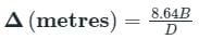
- The relation between Duty (D), Delta (Δ) and Base period (B) is given as:
Commonly adopted moisture tension, in atmosphere, of a soil at permanent wilting point is
- a)15
- b)7
- c)45
- d)150
Correct answer is option 'A'. Can you explain this answer?
Commonly adopted moisture tension, in atmosphere, of a soil at permanent wilting point is
a)
15
b)
7
c)
45
d)
150
|
|
Sravya Tiwari answered |
The soil moisture tension at the permanent wilting point is usually around 15 atmospheres or -15 bars. This is the point at which plants can no longer extract enough water to meet their needs and remain wilted until water is added to the soil.
The efficiency of water conveyance does not depend upon
- a)method of application of water
- b)geometry of the conveyance system
- c)nature of the boundary of the conveyance system
- d)climatic conditions
Correct answer is option 'D'. Can you explain this answer?
The efficiency of water conveyance does not depend upon
a)
method of application of water
b)
geometry of the conveyance system
c)
nature of the boundary of the conveyance system
d)
climatic conditions
|
|
Srestha Datta answered |
Efficiency of Water Conveyance
Efficiency of water conveyance refers to the ability of the conveyance system to deliver water to the desired location without loss or wastage. It is an important aspect of water management and irrigation systems.
Factors Affecting Efficiency of Water Conveyance
There are several factors that can affect the efficiency of water conveyance, including:
1. Climatic conditions: The amount of water that can be conveyed through a system can be affected by climatic conditions such as temperature, humidity, and wind speed.
2. Geometry of the conveyance system: The size, shape, and layout of the conveyance system can affect its ability to transport water efficiently. Factors such as the slope, diameter, and length of the conveyance system can all impact its efficiency.
3. Nature of the boundary of the conveyance system: The type of material used to construct the conveyance system can affect its efficiency. Factors such as the roughness, porosity, and permeability of the material can all impact the conveyance of water.
4. Method of application of water: The method used to apply water to the crops or plants can also affect the efficiency of the conveyance system. Factors such as the type of sprinkler system, drip irrigation, or flood irrigation used can all impact the efficiency of the system.
The Correct Answer
Based on the factors mentioned above, it can be concluded that the efficiency of water conveyance does not depend on the method of application of water. This means that regardless of the method used to apply water, the efficiency of the conveyance system will remain the same as long as other factors are held constant.
Determine its distribution efficiency when mean depth of water is 1.5 cm and the mean deviation from the mean is 0.1 cm. - a)15%
- b)85%
- c)66.66%
- d)93%
Correct answer is option 'D'. Can you explain this answer?
Determine its distribution efficiency when mean depth of water is 1.5 cm and the mean deviation from the mean is 0.1 cm.
a)
15%
b)
85%
c)
66.66%
d)
93%
|
|
Pallabi Chavan answered |
Distribution efficiency is a measure of how well a system is able to distribute a resource uniformly. In this case, we are calculating the distribution efficiency of water depth in a given system.
Given:
Mean depth of water = 1.5 cm
Mean deviation from the mean = 0.1 cm
The distribution efficiency can be calculated using the formula:
Distribution Efficiency = (1 - (Mean Deviation / Mean Depth)) * 100
1. Calculate the Mean Deviation:
Mean Deviation is the average of the absolute differences between each data point and the mean.
Mean Deviation = (|1.5 - 1.5| + |1.6 - 1.5| + |1.4 - 1.5| + ... + |x - 1.5|) / n
Since we do not have the actual data points, we can use the given Mean Deviation value of 0.1 cm.
Mean Deviation = 0.1 cm
2. Calculate the Distribution Efficiency:
Distribution Efficiency = (1 - (0.1 / 1.5)) * 100
= (1 - 0.0667) * 100
= 0.9333 * 100
= 93.33%
Therefore, the distribution efficiency when the mean depth of water is 1.5 cm and the mean deviation from the mean is 0.1 cm is approximately 93%. Hence, the correct answer is option 'D'.
Conjunctive use of water in a basin means- a)combined use of water for irrigation and for hydropower generation
- b)combined use of surface and ground water resources
- c)use of irrigation water by cooperation of farmers
- d)use of irrigation water for both rabi and kharif crops
Correct answer is option 'B'. Can you explain this answer?
Conjunctive use of water in a basin means
a)
combined use of water for irrigation and for hydropower generation
b)
combined use of surface and ground water resources
c)
use of irrigation water by cooperation of farmers
d)
use of irrigation water for both rabi and kharif crops
|
|
Prasad Desai answered |
Conjunctive use of water in a basin refers to the coordinated use of both surface water and groundwater resources. It involves managing the two sources of water in a way that optimizes their combined use and minimizes the negative impacts of their overuse.
Explanation:
Conjunctive use of water is an important strategy for managing water resources in areas where surface water and groundwater are both available. It involves using both sources of water in a coordinated manner to meet the water needs of different users while also maintaining the long-term sustainability of the water resources.
The following are some of the key aspects of conjunctive use of water in a basin:
1. Combined use of surface and groundwater resources: Conjunctive use involves using both surface water and groundwater resources in a coordinated and integrated manner. This can involve diverting surface water to recharge aquifers, pumping groundwater to supplement surface water supplies during dry periods, or using surface water to offset the overuse of groundwater.
2. Optimization of water use: Conjunctive use aims to optimize the use of water resources by balancing the demand for water with the available supply. This can involve allocating water resources based on the needs of different users, such as farmers, households, or industries, and managing the water resources to ensure that they are used efficiently and sustainably.
3. Minimization of negative impacts: Conjunctive use also aims to minimize the negative impacts of water use on the environment, including the depletion of aquifers, the degradation of water quality, and the loss of biodiversity. This can involve managing water resources to ensure that they are used in a way that minimizes their impact on the environment, while also meeting the needs of different users.
4. Collaboration among stakeholders: Conjunctive use requires collaboration among different stakeholders, including water users, government agencies, and civil society organizations. This can involve developing policies and regulations that promote the sustainable use of water resources, as well as engaging in dialogue and consultation with different stakeholders to ensure that their needs and concerns are taken into account.
In conclusion, conjunctive use of water in a basin involves managing both surface water and groundwater resources in a way that optimizes their combined use and minimizes the negative impacts of their overuse. It is an important strategy for ensuring the long-term sustainability of water resources in areas where both sources of water are available.
The method of irrigation adopted at places where there exists acute scarcity of irrigation water is:- a)Sprinkler irrigation method
- b)Furrow irrigation method
- c)Drip irrigation method
- d)More than one of the above
Correct answer is option 'C'. Can you explain this answer?
The method of irrigation adopted at places where there exists acute scarcity of irrigation water is:
a)
Sprinkler irrigation method
b)
Furrow irrigation method
c)
Drip irrigation method
d)
More than one of the above

|
Machine Experts answered |
Drip irrigation method
Net irrigation requirement of a crop is equal to- a)consumptive use
- b)consumptive use - effective rainfall
- c)consumptive use - effective rainfall + leaching and other requirements
- d)percolation loss + effective rainfall
Correct answer is option 'C'. Can you explain this answer?
Net irrigation requirement of a crop is equal to
a)
consumptive use
b)
consumptive use - effective rainfall
c)
consumptive use - effective rainfall + leaching and other requirements
d)
percolation loss + effective rainfall
|
|
Tanishq Menon answered |
Net Irrigation Requirement (N!R) is the amount of irrigation water required in order to meet the evapotranspiration need of the crop as well another, needs such as leaching. Therefore, NIR = Cu - Re + Water lost as percolation in satisfying other needs such as teaching.
In an irrigation system, water was delivered to the field in ditches spaced about 30 m apart, and was allowed to seep into the ground to maintain the water table at such a height that the water is available to the crops through the capillary fringe. This method of irrigation is called.- a)trickle irrigation
- b)furrow irrigation
- c)border irrigation
- d)sub irrigation
Correct answer is option 'D'. Can you explain this answer?
In an irrigation system, water was delivered to the field in ditches spaced about 30 m apart, and was allowed to seep into the ground to maintain the water table at such a height that the water is available to the crops through the capillary fringe. This method of irrigation is called.
a)
trickle irrigation
b)
furrow irrigation
c)
border irrigation
d)
sub irrigation
|
|
Diya Sarkar answered |
When a system of open jointed drains is artificially laid below the soil, so as to supply water to the crops by capillarity, then it is known as artificial sub-irrigation. It may be recommended only in some special cases with favourable soil conditions and for cash crops of high return.
Consumptive use of water for a crop represents- a)The transpiration needs of the crop
- b)evaporation needs of the cropped area
- c)evapotranspiration needs of the cropped area plus the minor quantity required in plant metabolism
- d)None of the above
Correct answer is option 'C'. Can you explain this answer?
Consumptive use of water for a crop represents
a)
The transpiration needs of the crop
b)
evaporation needs of the cropped area
c)
evapotranspiration needs of the cropped area plus the minor quantity required in plant metabolism
d)
None of the above
|
|
Naina Das answered |
Crop consumptive water use is the amount of water transpired during plant growth plus what evaporates from the soil surface and foliage in the crop area. In short, evapotranspiration needs of cropped area plus the minor quantity required in plant metabolism.
In an assumption made in the Bligh's Creep Theory for design of impervious floor for sub surface flow, the hydraulic gradient- a)increases throughout the impervious length of the apron
- b)decreases from upstream side to downstream side of the structure
- c)is always zero only in the middle of the impervious length of the apron
- d)is constant throughout the impervious length of the apron
Correct answer is option 'D'. Can you explain this answer?
In an assumption made in the Bligh's Creep Theory for design of impervious floor for sub surface flow, the hydraulic gradient
a)
increases throughout the impervious length of the apron
b)
decreases from upstream side to downstream side of the structure
c)
is always zero only in the middle of the impervious length of the apron
d)
is constant throughout the impervious length of the apron
|
|
Aditya Jain answered |
Bligh's Creep Theory and Impervious Floors
Bligh's Creep Theory is a method used in the design of impervious floors for sub-surface flow. The theory is based on the assumption that the soil particles just below the impervious layer creep slowly under load. This causes a hydraulic gradient that can be calculated using certain assumptions.
Hydraulic Gradient
The hydraulic gradient is defined as the change in hydraulic head per unit distance along the flow path. It is a measure of the pressure difference that drives the flow of water through the soil. In the case of an impervious floor, the hydraulic gradient is assumed to be constant throughout the impervious length of the apron.
Assumption of Constant Hydraulic Gradient
The assumption of a constant hydraulic gradient throughout the impervious length of the apron is based on the fact that the soil particles just below the impervious layer are assumed to be in a state of equilibrium. This means that they are not moving and there is no net flow of water through the soil.
This assumption is valid only if the hydraulic gradient is constant. If the gradient were to change, then there would be a net flow of water through the soil, which would cause the soil particles to move and the hydraulic gradient to change again. This would result in a cyclical process of soil movement and hydraulic gradient change, which is not desirable.
Conclusion
In conclusion, the correct answer to the question is option 'D', which states that the hydraulic gradient is constant throughout the impervious length of the apron. This assumption is based on the fact that the soil particles just below the impervious layer are assumed to be in a state of equilibrium and not moving. A constant hydraulic gradient ensures that there is no net flow of water through the soil and prevents the cyclical process of soil movement and hydraulic gradient change.
The minimum furrow grade to assure surface drainage is:- a)0.09%
- b)0.02%
- c)0.07%
- d)0.05%
Correct answer is option 'D'. Can you explain this answer?
The minimum furrow grade to assure surface drainage is:
a)
0.09%
b)
0.02%
c)
0.07%
d)
0.05%
|
|
Sanya Agarwal answered |
Furrow is a long, narrow irrigation trench made in the ground used for an optimal supply of water.
Furrows can be level and are very similar to long narrow basins. However, a minimum grade of 0.05% is recommended so that effective drainage can occur following irrigation or excessive rainfall.
Furrows can be level and are very similar to long narrow basins. However, a minimum grade of 0.05% is recommended so that effective drainage can occur following irrigation or excessive rainfall.
Important points:
The maximum recommended furrow slope is 0.5% to avoid soil erosion. Furrows can be set when the mainland slope does not exceed 3%. Beyond this, there is a major risk of soil erosion following a breach in the furrow system. On steep land, terraces can also be constructed and furrows cultivated along the terraces.
The maximum recommended furrow slope is 0.5% to avoid soil erosion. Furrows can be set when the mainland slope does not exceed 3%. Beyond this, there is a major risk of soil erosion following a breach in the furrow system. On steep land, terraces can also be constructed and furrows cultivated along the terraces.
The duty of irrigation water for a given crop is maximum
- a)on the field
- b)at the head of the main canal
- c)at the head of the water-course
- d)None of these
Correct answer is option 'A'. Can you explain this answer?
The duty of irrigation water for a given crop is maximum
a)
on the field
b)
at the head of the main canal
c)
at the head of the water-course
d)
None of these
|
|
Simran Saha answered |
Concept:
Duty:
Duty:
- It is the number of hectares of land irrigated for full growth of a given crop by a supply of 1 cumec of water continuously during the entire base period of that crop.
- Duty is the area that can be irrigated by the discharge of 1 cumec of water.
- At the head of the canal, there are numerous losses to occur later which requires more amount of water to irrigate a particular field. However, if considered on the field, all losses have already occurred and a lesser amount of water is required to irrigate the same considered area.
- Duty of water changes from place to place, it will be maximum at the field and minimum at the head of the canal.
Over irrigation results in –- a)Water-logging
- b)Wilting
- c)Fertility
- d)None of the above
Correct answer is option 'A'. Can you explain this answer?
Over irrigation results in –
a)
Water-logging
b)
Wilting
c)
Fertility
d)
None of the above
|
|
Akash Mukherjee answered |
Several negative consequences, including:
1. Waterlogging: Excess water from over irrigation can accumulate in the soil, leading to waterlogging. This can limit the availability of oxygen to plant roots, causing root damage and ultimately plant death.
2. Salinization: Over irrigation can cause the buildup of salts in the soil. As water evaporates, salts are left behind, and over time, their concentration can increase to levels that are toxic to plants. This can lead to reduced crop yields and the degradation of agricultural land.
3. Nutrient leaching: Excessive irrigation can wash away essential nutrients from the soil, a process known as leaching. This reduces the availability of nutrients for plant uptake, resulting in nutrient deficiencies and poor crop growth.
4. Environmental impact: Over irrigation can lead to the depletion of water resources, as excessive amounts of water are used. This can result in the drying up of rivers, lakes, and aquifers, affecting ecosystems and biodiversity. It can also exacerbate water scarcity issues in regions where water resources are already limited.
5. Increased energy consumption: Over irrigation requires more water to be pumped, distributed, and applied. This increases energy consumption, contributing to greenhouse gas emissions and climate change.
6. Economic implications: Over irrigation can lead to increased production costs for farmers, as they need to invest in additional water, energy, and irrigation infrastructure. It can also result in reduced crop yields and lower quality produce, leading to financial losses for agricultural businesses.
Overall, over irrigation can have serious environmental, economic, and social consequences, highlighting the importance of sustainable water management practices in agriculture.
The ratio of the average load to the installed capacity of the plant whose reserve capacity is zero will be equal to- a)Load factor
- b)Plant factor
- c)Utilization factor
- d)Both (A) and (B)
Correct answer is option 'D'. Can you explain this answer?
The ratio of the average load to the installed capacity of the plant whose reserve capacity is zero will be equal to
a)
Load factor
b)
Plant factor
c)
Utilization factor
d)
Both (A) and (B)
|
|
Gowri Singh answered |
Ratio of Average Load to Installed Capacity with Zero Reserve Capacity
When the reserve capacity of a power plant is zero, it means that there is no extra capacity available to meet unexpected or sudden increases in demand. In this scenario, the ratio of the average load to the installed capacity can be calculated using the following factors:
Load Factor
The load factor is the ratio of the average load to the maximum demand during a given period of time. It represents the average utilization of the installed capacity of the plant. The load factor can be calculated as follows:
Load factor = Average load / Maximum demand
Plant Factor
The plant factor is the ratio of the actual energy generated by the plant to the maximum energy that could have been generated if the plant had been operated at full capacity for the same period. It represents the actual utilization of the installed capacity of the plant. The plant factor can be calculated as follows:
Plant factor = Actual energy generated / (Installed capacity × Time)
Utilization Factor
The utilization factor is the ratio of the actual energy generated by the plant to the energy that could have been generated if the plant had been operated at full capacity for the same period. It represents the efficiency of the plant in utilizing its installed capacity. The utilization factor can be calculated as follows:
Utilization factor = Actual energy generated / (Installed capacity × Time)
Conclusion
When the reserve capacity of a power plant is zero, the ratio of the average load to the installed capacity can be calculated using the load factor and plant factor. Both factors give an indication of the utilization of the installed capacity of the plant. Therefore, the correct option is (D) - Both (A) and (B).
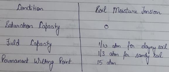
The moisture content of the soil, after free drainage has removed, most of the gravity water is known as :- a)Field capacity
- b)Saturation capacity
- c)Wilting co-efficient
- d)Available moisture
Correct answer is option 'A'. Can you explain this answer?
The moisture content of the soil, after free drainage has removed, most of the gravity water is known as :
a)
Field capacity
b)
Saturation capacity
c)
Wilting co-efficient
d)
Available moisture
|
|
Akshat Datta answered |
**Field Capacity**
The moisture content of the soil, after free drainage has removed most of the gravity water, is known as field capacity. It represents the amount of water retained in the soil after excess water has drained away due to gravity.
**Explanation:**
1. **Soil Moisture**:
- Soil moisture refers to the water content present in the soil.
- It is essential for plant growth and plays a crucial role in various soil processes.
- The moisture content in the soil is influenced by factors such as precipitation, evaporation, transpiration, and drainage.
2. **Gravity Water**:
- Gravity water is the water that is held in the soil due to the force of gravity.
- When the soil is saturated, excess water drains away due to gravity.
- This drainage process continues until the amount of water retained in the soil reaches the field capacity.
3. **Field Capacity**:
- Field capacity is defined as the moisture content of the soil after free drainage has removed most of the gravity water.
- It represents the amount of water held by the soil against the force of gravity.
- At field capacity, the soil is considered to be well-drained, and excess water has drained away.
4. **Measurement of Field Capacity**:
- Field capacity is determined by conducting a field or laboratory experiment.
- In the field, it can be measured by collecting soil samples from the desired depth and determining the moisture content using various methods such as the gravimetric method or the use of soil moisture sensors.
- In the laboratory, soil samples are collected and subjected to controlled conditions to allow for drainage and measurement of the moisture content at field capacity.
5. **Importance**:
- Field capacity is an important parameter in agriculture and civil engineering.
- In agriculture, it helps determine the amount of water available to plants and aids in irrigation scheduling.
- In civil engineering, it is used in the design of drainage systems and the calculation of soil water balance.
In conclusion, the moisture content of the soil after free drainage has removed most of the gravity water is known as field capacity. It represents the amount of water held by the soil against gravity and is an important parameter in agriculture and civil engineering.
A straight glacis type fall with a baffle platform and a baffle wall is called- a)Vertical drop-fall
- b)Glacis fall
- c)Montague type fall
- d)Inglis fall
Correct answer is option 'D'. Can you explain this answer?
A straight glacis type fall with a baffle platform and a baffle wall is called
a)
Vertical drop-fall
b)
Glacis fall
c)
Montague type fall
d)
Inglis fall
|
|
Sai Sarkar answered |
Inglis Fall
An Inglis Fall is a type of straight glacis type fall with a baffle platform and a baffle wall. It is commonly used in spillways and dam structures to control the flow of water.
Components of an Inglis Fall
1. Glacis: A glacis is a sloping surface that allows the water to flow down smoothly. In an Inglis Fall, the glacis is straight and inclined at an angle to the horizontal.
2. Baffle Platform: A baffle platform is a horizontal surface that is placed at the bottom of the glacis. It helps to reduce the velocity of the water and prevent erosion of the riverbed.
3. Baffle Wall: A baffle wall is a vertical barrier that is placed at the end of the baffle platform. It helps to dissipate the energy of the water and prevent it from splashing back.
Advantages of an Inglis Fall
1. Easy to construct: An Inglis Fall is easy to construct and requires minimal maintenance.
2. Efficient: It is an efficient method of controlling the flow of water and preventing erosion.
3. Cost-effective: An Inglis Fall is a cost-effective solution for managing water flow and preventing damage to the riverbed.
Conclusion
An Inglis Fall is a type of straight glacis type fall with a baffle platform and a baffle wall that is commonly used in spillways and dam structures. It is an efficient and cost-effective solution for managing water flow and preventing damage to the riverbed.
Which of the following is a plantation type of crop?- a)Ground nut
- b)Tea
- c)Fodder
- d)Sugarcane
Correct answer is option 'B'. Can you explain this answer?
Which of the following is a plantation type of crop?
a)
Ground nut
b)
Tea
c)
Fodder
d)
Sugarcane
|
|
Sanya Agarwal answered |
The plantation crop refers to those crops which are cultivated on an extensive scale in an area. In this type of agriculture, single crop is raised on a large area.
These crops include tea, coffee, rubber, cocoa, coconut, oil palm and cashew etc.
Other type of Crop categories in India:
These crops include tea, coffee, rubber, cocoa, coconut, oil palm and cashew etc.
Other type of Crop categories in India:
- Food Crops: Wheat, Maze, Rice, Millet, Pulses.
- Cash Crops: Sugar cane, Tobacco, Jute, Oilseeds.
- Horticulture Crops: Fruits and Vegetables.
The maximum application rate by sprinklers is limited by- a)the infiltration capacity of the,soil
- b)the prevailing wind velocity
- c)the quantity of water available
- d)the prevailing humidity and radiation
Correct answer is option 'A'. Can you explain this answer?
The maximum application rate by sprinklers is limited by
a)
the infiltration capacity of the,soil
b)
the prevailing wind velocity
c)
the quantity of water available
d)
the prevailing humidity and radiation
|
|
Anand Kumar answered |
Explanation:
The maximum application rate by sprinklers is limited by the infiltration capacity of the soil. This means that the amount of water that can be applied through sprinklers depends on the ability of the soil to absorb the water. If the soil is unable to absorb the water at the same rate at which it is being applied, the excess water will run off and cause erosion, and may also result in waterlogging and damage to crops. This is why it is important to determine the infiltration capacity of the soil before deciding on the application rate of sprinklers.
Factors affecting the infiltration capacity of soil:
There are several factors that affect the infiltration capacity of soil, including:
1. Soil texture: Soil texture refers to the size of the particles that make up the soil. Soils with larger particles, such as sand, have a higher infiltration rate than soils with smaller particles, such as clay.
2. Soil structure: The arrangement of soil particles also affects the infiltration rate. Well-structured soils with good pore space allow water to penetrate more easily.
3. Soil organic matter: Soils with high organic matter content have a higher infiltration rate because the organic matter helps to improve soil structure.
4. Soil compaction: Compacted soils have a lower infiltration rate because there is less pore space for water to penetrate.
5. Slope: The slope of the land affects the infiltration rate because water may run off rather than soaking into the soil.
Conclusion:
Overall, the infiltration capacity of soil is an important factor to consider when determining the maximum application rate of sprinklers. By understanding the factors that affect infiltration, it is possible to select an appropriate application rate that ensures efficient use of water while also protecting the soil and crops from damage.
The most suitable chemical which can be applied to the water surface for reducing evaporation is- a)Methyl alcohol
- b)Ethyl alcohol
- c)Cetyl alcohol
- d)Butyl alcohol
Correct answer is option 'C'. Can you explain this answer?
The most suitable chemical which can be applied to the water surface for reducing evaporation is
a)
Methyl alcohol
b)
Ethyl alcohol
c)
Cetyl alcohol
d)
Butyl alcohol
|
|
Shilpa Pillai answered |
The most suitable chemical for reducing evaporation on the water surface is cetyl alcohol.
Cetyl alcohol, also known as 1-hexadecanol, is a fatty alcohol derived from natural sources such as coconut oil or palm oil. It is commonly used in cosmetic and personal care products as an emollient, thickening agent, and emulsifier.
**Explanation:**
Cetyl alcohol has certain properties that make it suitable for reducing evaporation on the water surface. These properties include:
1. **High boiling point:** Cetyl alcohol has a relatively high boiling point of around 344°C (651°F). This means that it can withstand high temperatures without evaporating easily. When applied to the water surface, it forms a thin layer that acts as a barrier, preventing the water from evaporating.
2. **Low volatility:** Cetyl alcohol has a low vapor pressure, which means that it doesn't readily evaporate into the air. This property allows it to remain on the water surface for an extended period, providing long-lasting protection against evaporation.
3. **Non-toxic and environmentally friendly:** Cetyl alcohol is considered safe for use in various applications, including cosmetics and personal care products. It is non-toxic and biodegradable, making it an environmentally friendly option for reducing evaporation on the water surface.
4. **Insolubility in water:** Cetyl alcohol is insoluble in water, which means that it doesn't mix with the water molecules. Instead, it forms a separate layer on the water surface, creating a physical barrier that reduces evaporation.
Overall, cetyl alcohol is a suitable chemical for reducing evaporation on the water surface due to its high boiling point, low volatility, non-toxicity, and insolubility in water. By forming a thin layer on the water surface, it helps to minimize evaporation and conserve water resources.
Irrigation of a field is normally warranted when the available moisture content in the root zone of a crop is depleted by about- a)10%
- b)100%
- c)0%
- d)50%
Correct answer is option 'D'. Can you explain this answer?
Irrigation of a field is normally warranted when the available moisture content in the root zone of a crop is depleted by about
a)
10%
b)
100%
c)
0%
d)
50%
|
|
Sahil Chawla answered |
Irrigation of a field is normally warranted when the available moisture content in the root zone of a crop is depleted by about 50%. This means that the soil moisture content has decreased to half of its full capacity, and the crop requires water to maintain its growth and yield. Let's understand this concept in detail:
Factors affecting irrigation:
- Climate and weather conditions
- Soil type and texture
- Crop type and growth stage
- Irrigation system efficiency
Root zone and moisture content:
- Root zone is the area in the soil where the crop roots grow and extract moisture and nutrients
- Soil moisture content is the amount of water present in the soil, which can be measured in terms of percentage of water holding capacity
- Available moisture content is the portion of soil moisture that can be extracted by plant roots for their growth and development
When to irrigate:
- Irrigation should be done when the available moisture content in the root zone is depleted by about 50%
- This threshold may vary depending on the crop type, weather conditions and soil properties
- If the soil moisture content falls below 50%, the crop may suffer from water stress, which can affect its yield and quality
- However, over-irrigation can also be harmful to the crop, as it can lead to waterlogging, leaching of nutrients and soil compaction
Conclusion:
Irrigation is an important aspect of crop production, and its timing and frequency should be based on the available moisture content in the root zone. By maintaining the soil moisture at an optimal level, we can ensure the growth and yield of crops, while minimizing the water use and environmental impact.
Flow irrigation is done from –- a)Canals
- b)Wells
- c)Tube wells
- d)None of the above
Correct answer is option 'A'. Can you explain this answer?
Flow irrigation is done from –
a)
Canals
b)
Wells
c)
Tube wells
d)
None of the above
|
|
Sreemoyee Joshi answered |
A source of water, such as a river, lake, or reservoir. The water is diverted from the source and distributed through a network of canals, ditches, or pipes to the fields or crops that need irrigation. The water flows naturally by gravity from higher to lower elevations, providing a continuous supply of water to the plants. Flow irrigation is often used in agriculture to provide water to crops for growth and development.
In contour border irrigation method- a)the supply ditch runs along the contour
- b)the drainage channel runs along the contour
- c)the border strips are on the approximate contour and have uniform longitudinal gradient
- d)the border strips are normal to the contour and level across the strip
Correct answer is option 'C'. Can you explain this answer?
In contour border irrigation method
a)
the supply ditch runs along the contour
b)
the drainage channel runs along the contour
c)
the border strips are on the approximate contour and have uniform longitudinal gradient
d)
the border strips are normal to the contour and level across the strip
|
|
Jay Menon answered |
In contour border irrigation method, the correct answer is option 'C' - the border strips are on the approximate contour and have uniform longitudinal gradient. This method of irrigation involves the use of border strips that are aligned with the contour of the land and have a consistent slope along their length.
Here is an explanation of why option 'C' is correct:
1. Contour Alignment: In contour border irrigation, the border strips are laid out along the approximate contour of the land. This means that the strips follow the natural slope of the terrain, running parallel to the contour lines. This alignment helps to prevent water runoff and facilitates the uniform distribution of water across the field.
2. Uniform Longitudinal Gradient: The border strips in contour border irrigation have a consistent slope along their length. This means that the strips gradually rise or fall, maintaining a uniform gradient. This gradient is important for achieving even water distribution and preventing water from pooling in certain areas.
3. Water Application: In this method, water is supplied to the border strips from a supply ditch that runs along the contour. The water flows into the border strips and infiltrates the soil, providing moisture to the plants. The contour alignment of the border strips ensures that the water spreads evenly across the field, minimizing water wastage and maximizing irrigation efficiency.
4. Preventing Erosion: Contour border irrigation helps to prevent soil erosion by slowing down the flow of water. As the water follows the natural contour of the land, it moves at a slower pace, reducing the risk of erosion. Additionally, the border strips act as barriers, preventing water from flowing downhill and causing erosion in lower-lying areas.
5. Soil Conservation: This method of irrigation is beneficial for soil conservation. By aligning the border strips with the contour, the water infiltrates the soil more effectively and reduces the risk of soil erosion. It also helps in retaining moisture in the root zone of the plants, improving their growth and productivity.
Overall, contour border irrigation is a sustainable and efficient method of irrigation that ensures uniform water distribution, prevents soil erosion, and promotes soil conservation. The use of border strips aligned with the approximate contour and having a uniform longitudinal gradient is key to the success of this irrigation technique.
Super – fluous water is also called :- a)Capillary water
- b)Gravitational water
- c)Hygroscopic water
- d)None of the above
Correct answer is option 'B'. Can you explain this answer?
Super – fluous water is also called :
a)
Capillary water
b)
Gravitational water
c)
Hygroscopic water
d)
None of the above

|
Rutuja Deshpande answered |
Sorry, could you please provide more context or information about what you are referring to?
In border method of irrigation, the flow along the border is a case of- a)spatially varied, unsteady, open channel flow with decreasing discharges
- b)steady, spatially varied open channel flow with decreasing discharges
- c)unsteady gradually varied, open channel flow
- d)unsteady, uniform, open channel flow
Correct answer is option 'A'. Can you explain this answer?
In border method of irrigation, the flow along the border is a case of
a)
spatially varied, unsteady, open channel flow with decreasing discharges
b)
steady, spatially varied open channel flow with decreasing discharges
c)
unsteady gradually varied, open channel flow
d)
unsteady, uniform, open channel flow
|
|
Gauri Roy answered |
Explanation:
Border irrigation is a surface irrigation method where water is applied to a strip of land between two borders. The water is allowed to flow along the border and infiltrate into the soil. The flow along the border can be analyzed as a case of spatially varied, unsteady, open channel flow with decreasing discharges.
Spatially Varied Flow:
In border irrigation, the water flow varies along the length of the border due to the differences in the soil infiltration rates and surface slopes. The flow depth and velocity also vary along the border, making it a case of spatially varied flow.
Unsteady Flow:
The flow in border irrigation is unsteady as the discharge varies with time due to the changing water level and infiltration rates. The flow is also affected by the inflow and outflow rates, making it unsteady.
Open Channel Flow:
In border irrigation, the water flows in an open channel, which is not completely enclosed. The water surface is exposed to the atmosphere, and the flow is affected by external factors such as wind, evaporation, and infiltration.
Decreasing Discharges:
As the water flows along the border, it infiltrates into the soil, reducing the discharge. The discharge also varies along the border due to the spatially varied flow, making it a case of decreasing discharges.
Conclusion:
Thus, the flow along the border in border irrigation can be analyzed as a case of spatially varied, unsteady, open channel flow with decreasing discharges.
The meander pattern of a river is developed by- a)Average discharge
- b)Dominant discharge
- c)Maximum discharge
- d)Critical discharge
Correct answer is option 'B'. Can you explain this answer?
The meander pattern of a river is developed by
a)
Average discharge
b)
Dominant discharge
c)
Maximum discharge
d)
Critical discharge
|
|
Anirudh Kulkarni answered |
**Introduction:**
The meander pattern of a river refers to the winding and looping shape that a river takes as it flows across its floodplain. These curves are created by a combination of various factors, including the river's discharge, sediment load, and the characteristics of the surrounding landscape. Among these factors, the dominant discharge of the river plays a significant role in the development and maintenance of meander patterns.
**Explanation:**
The dominant discharge of a river refers to the average flow rate of water over a specified time period. It is the discharge that occurs most frequently and is responsible for shaping the river's channel and floodplain. The meandering pattern is largely influenced by the interaction between the flowing water and the riverbed. Here is how the dominant discharge influences the development of the meander pattern:
1. **Water Velocity:** The dominant discharge determines the velocity of the river water. Higher discharges typically result in higher flow velocities. As the water flows through the river channel, its velocity varies along the cross-section. The highest velocity occurs near the center of the channel, while the velocity decreases towards the banks. This variation in velocity across the channel leads to the migration of the river channel towards the outer banks, creating the characteristic bends of meanders.
2. **Erosion and Deposition:** The flow of water in a river is responsible for the erosion and deposition of sediment. During high discharges, the increased water velocity enables the river to transport and deposit larger amounts of sediment. As the water flows around the bends of a meander, the velocity decreases, leading to the deposition of sediment on the inner bank. This sediment deposition gradually builds up, resulting in the formation of point bars on the inner side of the bend. On the other hand, erosion occurs on the outer bank where the water velocity is higher, causing the formation of cut banks.
3. **Bank Stability:** The dominant discharge also affects the stability of the riverbanks. The erosion and deposition of sediment along the riverbanks can weaken or strengthen them, depending on the balance between the erosive and depositional forces. Higher discharges typically result in greater erosion, leading to the undercutting of the outer banks and the formation of steep cut banks. Conversely, the deposition of sediment on the inner banks helps to stabilize them and prevent excessive erosion.
**Conclusion:**
In conclusion, the dominant discharge of a river is a crucial factor in the development and maintenance of meander patterns. The flow velocity, erosion and deposition of sediment, and bank stability are all influenced by the dominant discharge. These factors work together to create the characteristic bends, point bars, and cut banks that define meandering rivers. Therefore, option B, which states that the meander pattern of a river is developed by the dominant discharge, is the correct answer.
Generally the weir is aligned at right angles to the direction of the main river current because- a)It ensures less length of the weir
- b)It gives better discharging capacity
- c)It is economical
- d)All of the above
Correct answer is option 'D'. Can you explain this answer?
Generally the weir is aligned at right angles to the direction of the main river current because
a)
It ensures less length of the weir
b)
It gives better discharging capacity
c)
It is economical
d)
All of the above
|
|
Bhaskar Mukherjee answered |
Alignment of Weir in Civil Engineering
Weirs are structures constructed across open channels for the purpose of measuring or regulating water flow. The alignment of the weir is an important aspect of its design, and it is generally recommended to align the weir at right angles to the direction of the main river current. The reasons for this are discussed below:
1. Less Length of Weir
Aligning the weir at right angles to the main river current ensures that the length of the weir is minimal. This is because the flow of water is perpendicular to the weir, which means that the width of the weir can be reduced without affecting its discharging capacity. This results in a more economical design, as less material is required for the construction of the weir.
2. Better Discharging Capacity
When the weir is aligned at right angles to the main river current, the flow of water is directed towards the crest of the weir. This creates a hydraulic jump, which increases the energy dissipation and results in a better discharging capacity. The hydraulic jump also helps to prevent erosion of the downstream channel bed, as the energy of the water is dissipated before it reaches the downstream section.
3. Economical
As mentioned earlier, aligning the weir at right angles to the main river current results in a more economical design, as less material is required for the construction of the weir. This is because the width of the weir can be reduced without affecting its discharging capacity.
Conclusion
In conclusion, the alignment of the weir at right angles to the main river current is recommended because it ensures a minimal length of the weir, better discharging capacity, and an economical design. However, the alignment of the weir should be based on the specific site conditions and the objectives of the project.
For growing irrigated paddy, the ideal water application method is- a)furrow irrigation
- b)check basin irrigation
- c)border method of irrigation
- d)sprinkler irrigation
Correct answer is option 'B'. Can you explain this answer?
For growing irrigated paddy, the ideal water application method is
a)
furrow irrigation
b)
check basin irrigation
c)
border method of irrigation
d)
sprinkler irrigation
|
|
Arya Menon answered |
Explanation:
The ideal water application method for growing irrigated paddy is check basin irrigation. This method involves the construction of small earthen bunds around the paddy fields, which form a basin or a pool. The water is then allowed to fill the basin up to a certain depth before it is gradually drained out. Check basin irrigation is a suitable method for paddy because it:
- Minimizes water loss through percolation and evaporation
- Ensures that the water is evenly distributed across the field
- Allows for the precise control of the water level in the basin
- Prevents waterlogging and soil erosion caused by excessive water flow
- Helps to maintain the ideal soil moisture conditions for paddy growth
The other water application methods such as furrow irrigation, border method of irrigation, and sprinkler irrigation are not suitable for paddy because:
- Furrow irrigation can lead to soil erosion and waterlogging, especially in sloping fields
- Border method of irrigation requires a lot of labor and is not suitable for large-scale cultivation
- Sprinkler irrigation can cause damage to the paddy plants and is not cost-effective for small farmers
Which of the following statements pertaining to sprinkler irrigation is not correct?- a)No extra cost of land preparation is involved in sprinkler irrigation.
- b)Excessive soil erosion is initiated by sprinkler irrigation.
- c)Sprinklers can be used for the application of liquid fertilizers also.
- d)Sprinkler irrigation is particularly advantageous in hilly terrains.
Correct answer is option 'B'. Can you explain this answer?
Which of the following statements pertaining to sprinkler irrigation is not correct?
a)
No extra cost of land preparation is involved in sprinkler irrigation.
b)
Excessive soil erosion is initiated by sprinkler irrigation.
c)
Sprinklers can be used for the application of liquid fertilizers also.
d)
Sprinkler irrigation is particularly advantageous in hilly terrains.
|
|
Sanaya Sengupta answered |
Sprinkler Irrigation
Sprinkler irrigation is a method of applying water to crops in a manner similar to rainfall. Water is distributed through a network of pipes and sprayed into the air through sprinklers, which break the water up into small droplets. The droplets fall to the ground and wet the crop.
Advantages of Sprinkler Irrigation
- No extra cost of land preparation is involved in sprinkler irrigation.
- Sprinklers can be used for the application of liquid fertilizers also.
- Sprinkler irrigation is particularly advantageous in hilly terrains.
Disadvantages of Sprinkler Irrigation
- Excessive soil erosion is initiated by sprinkler irrigation.
Explanation
Option B is incorrect because sprinkler irrigation does not initiate excessive soil erosion. In fact, sprinkler irrigation can help to reduce soil erosion as it allows for the controlled application of water to crops. This reduces the amount of runoff from the field, which can carry soil particles with it and cause erosion. Furthermore, the small droplets produced by sprinklers are less likely to cause soil compaction than larger droplets produced by other irrigation methods, such as furrow irrigation.
Conclusion
In conclusion, sprinkler irrigation is an effective method of applying water to crops, particularly in hilly terrains where other methods may not be feasible. While it has some disadvantages, such as the need for a reliable source of water and the potential for clogging of sprinklers, excessive soil erosion is not one of them.
Chapter doubts & questions for Methods of Irrigation - Irrigation Engineering 2025 is part of Civil Engineering (CE) exam preparation. The chapters have been prepared according to the Civil Engineering (CE) exam syllabus. The Chapter doubts & questions, notes, tests & MCQs are made for Civil Engineering (CE) 2025 Exam. Find important definitions, questions, notes, meanings, examples, exercises, MCQs and online tests here.
Chapter doubts & questions of Methods of Irrigation - Irrigation Engineering in English & Hindi are available as part of Civil Engineering (CE) exam.
Download more important topics, notes, lectures and mock test series for Civil Engineering (CE) Exam by signing up for free.
Irrigation Engineering
7 videos|35 docs|31 tests
|

Signup to see your scores go up within 7 days!
Study with 1000+ FREE Docs, Videos & Tests
10M+ students study on EduRev
|
© EduRev
|
Education Revolution
|


|


Signup to see your scores
go up within 7 days!
Access 1000+ FREE Docs, Videos and Tests
Takes less than 10 seconds to signup