


All Exams >
Class 6 >
GK Olympiad for Class 6 >
All Questions
All questions of World Geography for Class 6 Exam
Which continent is known as the "Land Down Under"?- a)Africa
- b)Australia
- c)Europe
- d)Asia
Correct answer is option 'B'. Can you explain this answer?
Which continent is known as the "Land Down Under"?
a)
Africa
b)
Australia
c)
Europe
d)
Asia
|
|
Muskaan reddy answered |
There is no continent known as "the." There are seven continents: Africa, Antarctica, Asia, Europe, North America, Oceania, and South America.

World’s second largest continent is - a)Asia
- b)Africa
- c)Antarctica
- d)Australia
Correct answer is option 'B'. Can you explain this answer?
World’s second largest continent is
a)
Asia
b)
Africa
c)
Antarctica
d)
Australia
|
|
Rajveer Banerjee answered |
The world is a term used to refer to the planet Earth and all the people, animals, plants, and other living organisms that inhabit it. It is a vast and complex system made up of different countries, cultures, languages, and ecosystems. The world is constantly changing and evolving, and is affected by various factors including climate change, globalization, technology, and politics. Despite its diversity and complexity, the world is interconnected and interdependent, and it is important for individuals and nations to work together to ensure its sustainability and well-being.
Which ocean is the largest in the world?- a)Indian Ocean
- b)Atlantic Ocean
- c)Pacific Ocean
- d)Arctic Ocean
Correct answer is option 'C'. Can you explain this answer?
Which ocean is the largest in the world?
a)
Indian Ocean
b)
Atlantic Ocean
c)
Pacific Ocean
d)
Arctic Ocean
|
|
Aditi Sharma answered |
The Pacific Ocean covers more area than all the world's landmasses combined.
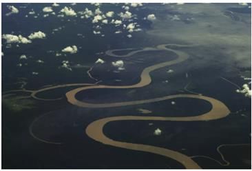
Which of the following is the deepest river in the world?- a)Amazon
- b)Nile
- c)Congo
- d)Volga
Correct answer is option 'C'. Can you explain this answer?
Which of the following is the deepest river in the world?
a)
Amazon
b)
Nile
c)
Congo
d)
Volga
|
|
Debolina Shah answered |
The Congo River is the deepest river in the world, with a maximum depth of over 720 feet (220 meters). This river is located in Central Africa, flowing through the Congo rainforest and eventually emptying into the Atlantic Ocean.
Factors that contribute to the depth of the Congo River include:
1. Tectonic activity: The region surrounding the Congo River is characterized by tectonic activity, which has led to the formation of deep rift valleys and steep slopes.
2. High precipitation: The Congo Basin, which encompasses much of the river's drainage area, receives high levels of precipitation. This results in rapid erosion and sediment deposition, which can deepen the river channel over time.
3. Slow flow: Despite the high volume of water that flows through the Congo River, the speed of the current is relatively slow. This allows sediment to settle to the bottom of the river, which can also contribute to its depth.
Overall, the combination of tectonic activity, high precipitation, and slow flow has resulted in the Congo River being the deepest river in the world.
Where is Lake Superior, the largest freshwater lake in the world located?- a)USA
- b)Brazil
- c)Canada
- d)Russia
Correct answer is option 'A'. Can you explain this answer?
Where is Lake Superior, the largest freshwater lake in the world located?
a)
USA
b)
Brazil
c)
Canada
d)
Russia

|
Preeti Sarkar answered |
The answer will be Russia, option number 4. plz check the answer in wikipedia. it will be a good help, thank you .have a nice day.
World’s coldest continent Antarctica is surrounded by- a)Western Ocean
- b)Southern Ocean
- c)Northern Ocean
- d)Eastern Ocean
Correct answer is option 'B'. Can you explain this answer?
World’s coldest continent Antarctica is surrounded by
a)
Western Ocean
b)
Southern Ocean
c)
Northern Ocean
d)
Eastern Ocean
|
|
Sarita Singh answered |
World’s coldest continent Antarctica is surrounded by southern ocean.
Which among the following rivers does not belong to Europe?- a)Volga
- b)Rhine
- c)Don
- d)Mississippi
Correct answer is option 'D'. Can you explain this answer?
Which among the following rivers does not belong to Europe?
a)
Volga
b)
Rhine
c)
Don
d)
Mississippi
|
|
Priyanka Mukherjee answered |
The correct answer is option 'D' - Mississippi.
Explanation:
Explanation:
Extensive stretched piece of land is classified as- a)hill
- b)plateau
- c)plain
- d)valley
Correct answer is option 'C'. Can you explain this answer?
Extensive stretched piece of land is classified as
a)
hill
b)
plateau
c)
plain
d)
valley
|
|
Varun Jain answered |
Plain
A plain is an extensive stretched piece of land that is characterized by flat or gently rolling land with no significant changes in elevation. It is one of the three main types of landforms, along with mountains and plateaus. Plains are typically found at lower altitudes and are often covered with grasses and shrubs.
Characteristics of a Plain:
- Flat or gently rolling land
- Little to no changes in elevation
- Fertile soil, making it ideal for agriculture
- Often located near rivers or bodies of water
- Vegetation primarily consists of grasses and shrubs
Examples of Plains:
- The Great Plains in North America
- The Indo-Gangetic Plain in South Asia
- The Pampas in South America
Importance of Plains:
- Plains are ideal for agriculture due to their fertile soil and flat terrain.
- They provide habitat for a variety of plant and animal species.
- Plains are often densely populated due to their suitability for human settlement and agriculture.
- They are important for transportation and infrastructure development due to their flat terrain.
In conclusion, an extensive stretched piece of land is classified as a plain due to its flat or gently rolling characteristics and lack of significant changes in elevation. Plains play a crucial role in supporting agriculture, providing habitat for wildlife, and facilitating human settlement and infrastructure development.
Country which is not located in Asia is- a)Sri Lanka
- b)North Korea
- c)Japan
- d)Tasmania
Correct answer is option 'D'. Can you explain this answer?
Country which is not located in Asia is
a)
Sri Lanka
b)
North Korea
c)
Japan
d)
Tasmania
|
|
Sanchita Kulkarni answered |
Understanding the Options
In this question, we need to identify which of the given locations is not situated in Asia. Let’s analyze each option:
Identifying the Correct Answer
Among the options provided:
- Sri Lanka, North Korea, and Japan are all countries located in Asia.
- Tasmania, on the other hand, is not in Asia; it is part of Australia.
This makes Tasmania the correct answer, as it is geographically distinct from the Asian continent.
Conclusion
In summary:
Thus, the correct answer to the question is option 'D', Tasmania.
In this question, we need to identify which of the given locations is not situated in Asia. Let’s analyze each option:
- Sri Lanka: This country is an island nation located in South Asia, just south of India.
- North Korea: North Korea is situated in East Asia, bordered by China and South Korea.
- Japan: Japan is also an island nation in East Asia, located in the Pacific Ocean.
- Tasmania: Tasmania is an island state of Australia, located in the Southern Hemisphere, far from Asia.
Identifying the Correct Answer
Among the options provided:
- Sri Lanka, North Korea, and Japan are all countries located in Asia.
- Tasmania, on the other hand, is not in Asia; it is part of Australia.
This makes Tasmania the correct answer, as it is geographically distinct from the Asian continent.
Conclusion
In summary:
- Tasmania is the only option that is not located in Asia.
- All other options (Sri Lanka, North Korea, and Japan) are Asian countries.
Thus, the correct answer to the question is option 'D', Tasmania.
Golan Heights belonging to country A was captured by country B. Which of the following are A and B respectively?- a)Syria and Israel
- b)Israel and Iraq
- c)Iran and Iraq
- d)Kuwait and Iraq
Correct answer is option 'A'. Can you explain this answer?
Golan Heights belonging to country A was captured by country B. Which of the following are A and B respectively?
a)
Syria and Israel
b)
Israel and Iraq
c)
Iran and Iraq
d)
Kuwait and Iraq
|
|
Sneha Rane answered |
Syria and Israel
The correct answer is option 'A', which states that the Golan Heights belonged to Syria and was captured by Israel. Let's delve into the details to understand why this is the correct answer.
Introduction:
The Golan Heights is a region located in the Middle East, specifically in southwestern Syria. It borders Lebanon, Jordan, and Israel. The area has a significant geopolitical and strategic importance due to its elevated terrain overlooking the surrounding regions. Throughout history, various countries have laid claim to the Golan Heights.
Historical Background:
1. Syrian Control:
- Prior to the capture, the Golan Heights belonged to Syria. It was part of the Syrian Arab Republic.
- Syria gained control of the area during the French Mandate period in the 1920s and maintained its rule until the capture.
Israeli Capture:
2. Six-Day War (1967):
- The Golan Heights came under Israeli control during the Six-Day War, a conflict that occurred between Israel and several Arab countries.
- In June 1967, Israel launched a preemptive strike against Egypt, Jordan, and Syria. The war resulted in Israel gaining control of the Sinai Peninsula, the West Bank, East Jerusalem, and the Golan Heights.
- Israel captured the Golan Heights from Syria during this war.
3. Israeli Annexation:
- In 1981, Israel officially annexed the Golan Heights, thereby establishing Israeli sovereignty over the region.
- This move was widely condemned by the international community, as it was considered a violation of international law and United Nations resolutions.
Conclusion:
In conclusion, the Golan Heights, which originally belonged to Syria, was captured by Israel during the Six-Day War in 1967. Israel subsequently annexed the region in 1981, a move that has not been recognized by the international community. Therefore, option 'A', which states that Syria and Israel are the respective countries, is the correct answer.
Which animal is known for its black and white stripes?- a)Lion
- b)Tiger
- c)Zebra
- d)Giraffe
Correct answer is option 'C'. Can you explain this answer?
Which animal is known for its black and white stripes?
a)
Lion
b)
Tiger
c)
Zebra
d)
Giraffe
|
|
Ajay rane answered |
Zebra
Zebra is known for its black and white stripes. Let's understand more about this unique animal:
Appearance
- Zebras have a black and white striped coat that helps them blend into their surroundings and confuse predators.
- Each zebra has a unique stripe pattern, similar to human fingerprints.
Habitat
- Zebras are native to Africa and can be found in grasslands, savannas, woodlands, and mountains.
- They are social animals and live in groups called 'harems' led by a dominant male.
Diet
- Zebras are herbivores and feed on grass, leaves, and stems.
- Their digestive system is specially adapted to break down tough plant material.
Behavior
- Zebras are known for their distinctive braying sound, which is a form of communication within their group.
- They are fast runners and can reach speeds of up to 65 km/h to escape predators.
Conservation
- Zebras are classified as a threatened species due to habitat loss, poaching, and competition with livestock for resources.
- Conservation efforts are in place to protect these beautiful animals and their habitats.
In conclusion, the black and white stripes of zebras are not only visually striking but also serve a practical purpose in their survival in the wild.
The low lying areas between two mountains or hills are known as _________.- a)rivers
- b)valleys
- c)plains
- d)plateaus
Correct answer is option 'B'. Can you explain this answer?
The low lying areas between two mountains or hills are known as _________.
a)
rivers
b)
valleys
c)
plains
d)
plateaus
|
|
Mehul Sharma answered |
Valleys
Valleys are low lying areas between two mountains or hills. They are formed by the erosion of the land by rivers and glaciers. Valleys have a characteristic V-shaped profile and are usually elongated in shape. They can be narrow or wide, deep or shallow, and can be found in various parts of the world.
Formation of Valleys
Valleys are formed by the natural processes of erosion and weathering. The following are the main processes that lead to the formation of valleys:
1. River Erosion - Rivers erode the land over time, carving out channels and gorges. As the water flows downhill, it picks up sediment and rocks, which it carries downstream. This process creates a valley.
2. Glacial Erosion - Glaciers are large masses of ice that move slowly over the land, carving out valleys as they go. They can create U-shaped valleys by scraping away the sides of the mountains or hills.
3. Tectonic Uplift - When mountains are formed due to tectonic activity, valleys are often created in the process. The pressure from uplifting rocks can cause the land to crack and break, forming valleys.
Types of Valleys
There are several types of valleys, depending on their formation and location. The following are the main types of valleys:
1. V-shaped valleys - These are the most common type of valleys and are formed by river erosion.
2. U-shaped valleys - These are formed by glacial erosion and have a wider, more rounded shape.
3. Rift valleys - These are formed when the Earth's crust is stretched and pulled apart.
4. Canyon - Canyons are deep, narrow valleys with steep sides, often carved by rivers.
Importance of Valleys
Valleys play an important role in the ecosystem as they provide habitats for various plant and animal species. They also provide fertile land for agriculture and are often home to human settlements. Valleys also have recreational and tourism value, as they offer scenic views and opportunities for outdoor activities such as hiking and camping.
What is gulf stream?- a)The name of a stream
- b)Streams joining a gulf
- c)Strong air current
- d)A warm ocean current
Correct answer is option 'D'. Can you explain this answer?
What is gulf stream?
a)
The name of a stream
b)
Streams joining a gulf
c)
Strong air current
d)
A warm ocean current
|
|
Kiran Das answered |
The Gulf Stream is a warm ocean current that flows in the Atlantic Ocean. It is one of the strongest and most important ocean currents in the world. The Gulf Stream starts in the Gulf of Mexico, hence the name, and then travels up the eastern coast of the United States before crossing the Atlantic Ocean towards Europe.
Here is a detailed explanation of the Gulf Stream:
1. Importance of Ocean Currents:
Ocean currents play a crucial role in the Earth's climate system by distributing heat around the planet. They act like giant conveyor belts, transporting warm and cold water across the oceans, which in turn affects weather patterns and climate.
2. Origin of the Gulf Stream:
The Gulf Stream originates in the Gulf of Mexico, where warm water from the Caribbean Sea enters the Gulf. This warm water is driven by a combination of factors such as wind, the rotation of the Earth, and differences in water density.
3. Path of the Gulf Stream:
Once the warm water enters the Gulf of Mexico, it forms a powerful current that flows northward along the eastern coast of the United States. It passes through the Straits of Florida and heads towards Cape Hatteras, North Carolina. From there, it veers northeastward and crosses the Atlantic Ocean towards Europe.
4. Characteristics of the Gulf Stream:
The Gulf Stream is characterized by its warm and fast-moving waters. It can reach speeds of up to 4 miles per hour and transports an enormous amount of heat energy. The water in the Gulf Stream is significantly warmer than the surrounding ocean, often by as much as 15 to 20 degrees Fahrenheit.
5. Influence on Climate and Weather:
The Gulf Stream has a significant impact on the climate and weather patterns of both North America and Europe. As it carries warm water northward, it helps moderate the climate along the eastern coast of the United States, making winters milder and summers cooler. In Europe, the Gulf Stream contributes to the mild climate of countries like the United Kingdom and Norway.
In conclusion, the Gulf Stream is a warm ocean current that plays a vital role in the Earth's climate system. It originates in the Gulf of Mexico, flows northward along the eastern coast of the United States, and crosses the Atlantic Ocean towards Europe. Its warm and fast-moving waters have a significant influence on climate and weather patterns in the regions it passes through.
Which one among the following rivers is the longest?- a)Amazon
- b)Amur
- c)Congo
- d)Yellow river
Correct answer is option 'A'. Can you explain this answer?
Which one among the following rivers is the longest?
a)
Amazon
b)
Amur
c)
Congo
d)
Yellow river
|
|
Varun Kapoor answered |
- The Nile is the longest river in the world with a length of 6650 km.
- Amazon is the second longest river in the world however, it is the largest in terms of water flow in the world.
- Mississipi-Missouri is the fourth longest river in the world and it flows only in two countries - the USA and Canada.
A large city of Switzerland, Headquarters of the Red Cross is- a)Karachi
- b)Havana
- c)Geneva
- d)Bangkok
Correct answer is option 'C'. Can you explain this answer?
A large city of Switzerland, Headquarters of the Red Cross is
a)
Karachi
b)
Havana
c)
Geneva
d)
Bangkok
|
|
Arindam Saha answered |
Answer:
Geneva is the correct answer because it is the headquarters of the Red Cross.
Explanation:
The Red Cross is an international humanitarian organization that provides assistance to those in need, including victims of natural disasters, armed conflicts, and health emergencies. It was founded in 1863 and has since grown to become one of the largest and most recognized humanitarian organizations in the world.
Geneva: The Headquarters of the Red Cross
Geneva, the second-largest city in Switzerland, is widely known as a hub for international diplomacy and humanitarian organizations. It is home to numerous international organizations, including the United Nations and its specialized agencies.
The headquarters of the Red Cross is located in Geneva, Switzerland. This city was chosen as the headquarters due to its long history of promoting humanitarian principles and its central location in Europe.
Importance of Geneva as a Headquarters
1. Neutral and Peaceful Location: Geneva has a long-standing tradition of neutrality and is often chosen as a venue for negotiations and peace talks. This neutral status makes it an ideal location for the headquarters of an organization like the Red Cross, which aims to provide assistance and support to people affected by conflicts and disasters.
2. Accessible Location: Geneva is well-connected by air, road, and rail, making it easily accessible for staff, volunteers, and delegates from around the world. Its proximity to major European cities also facilitates coordination and collaboration with other humanitarian organizations and governments.
3. International Community: Geneva is home to a diverse international community, including diplomats, humanitarian workers, and experts in various fields. This diverse community provides a valuable pool of talent and resources for the Red Cross headquarters, enabling it to carry out its mission effectively.
4. Humanitarian Tradition: Switzerland has a long-standing tradition of humanitarianism, dating back to the establishment of the International Committee of the Red Cross (ICRC) in Geneva in 1863. The presence of the Red Cross headquarters in Geneva further strengthens this tradition and reinforces Switzerland's commitment to humanitarian principles.
In conclusion, Geneva, Switzerland, is the headquarters of the Red Cross. Its central location, neutral status, and strong humanitarian tradition make it an ideal base for an organization dedicated to providing assistance and support to those in need.
Which is the largest gulf in the world?- a)Gulf of Thailand
- b)Gulf of Oman
- c)Gulf of Alaska
- d)Gulf of Mexico
Correct answer is option 'D'. Can you explain this answer?
Which is the largest gulf in the world?
a)
Gulf of Thailand
b)
Gulf of Oman
c)
Gulf of Alaska
d)
Gulf of Mexico
|
|
Anand Patel answered |
The Gulf of Mexico is the largest gulf in the world. Let's explore some facts about this gulf.
Geographical Location
The Gulf of Mexico is located in the Western Hemisphere and bordered by the United States to the north, Mexico to the west and south, and Cuba to the southeast.
Size
The Gulf of Mexico covers an area of approximately 1.5 million square kilometers, making it the largest gulf in the world.
Depth
The maximum depth of the Gulf of Mexico is around 4,384 meters. The average depth is around 1,615 meters.
Marine Life
The Gulf of Mexico is home to a diverse range of marine life, including various species of fish, sharks, dolphins, and sea turtles. The gulf is also home to several endangered species, such as the Gulf sturgeon and the Kemp's ridley sea turtle.
Importance
The Gulf of Mexico is an important economic resource. It is a major source of oil and natural gas, with many offshore oil rigs located in the gulf. The gulf is also an important fishing ground, with commercial fishing operations targeting species such as shrimp, oysters, and red snapper.
Conclusion
The Gulf of Mexico is not only the largest gulf in the world but also an important economic and ecological resource. Its diverse marine life and natural resources make it an important region for both conservation and human activity.
Which country is called the land of thousand lakes?- a)Ireland
- b)Canada
- c)Finland
- d)Norway
Correct answer is option 'C'. Can you explain this answer?
Which country is called the land of thousand lakes?
a)
Ireland
b)
Canada
c)
Finland
d)
Norway
|
|
Priya Pillai answered |
Finland is called the land of thousand lakes.
Finland is a country located in Northern Europe, bordered by Sweden, Norway, and Russia. It is known for its beautiful landscapes, including vast forests, northern lights, and of course, its thousands of lakes. Here are some reasons why Finland is called the land of thousand lakes:
Geography: Finland's geography is characterized by its many lakes, which are formed by glaciers and melting ice sheets. There are approximately 187,888 lakes in Finland, with a surface area of at least 500 square meters or larger. These lakes range from small ponds to large bodies of water, with the largest being Lake Saimaa, which covers an area of 4,400 square kilometers.
Culture: Lakes are an essential part of Finnish culture and tradition. They are used for swimming, fishing, boating, and other recreational activities. Finnish people are known for their love of nature and spending time outdoors. Many families own summer cottages by the lake, where they can relax and enjoy the beautiful scenery.
Economy: Lakes also play an important role in Finland's economy. They are a source of freshwater for drinking, irrigation, and hydropower production. Many fish species are also found in Finnish lakes, which are commercially important for fishing and aquaculture.
In conclusion, Finland's numerous lakes are an essential part of its geography, culture, and economy. With their pristine waters, beautiful scenery, and recreational opportunities, it is no wonder why Finland is known as the land of thousand lakes.
Which country is famous for the pyramids of Giza?- a)Egypt
- b)Greece
- c)Mexico
- d)Italy
Correct answer is option 'A'. Can you explain this answer?
Which country is famous for the pyramids of Giza?
a)
Egypt
b)
Greece
c)
Mexico
d)
Italy
|
|
Aditi Sharma answered |
The pyramids of Giza, including the Great Pyramid of Khufu, are located near Cairo, the capital of Egypt.
Which continent is entirely in the Southern Hemisphere?- a)Europe
- b)Africa
- c)Asia
- d)Antarctica
Correct answer is option 'D'. Can you explain this answer?
Which continent is entirely in the Southern Hemisphere?
a)
Europe
b)
Africa
c)
Asia
d)
Antarctica
|
|
Abhinav chandra answered |
Continent entirely in the Southern Hemisphere: Antarctica
Antarctica is the continent that is entirely located in the Southern Hemisphere. It is the southernmost continent and is primarily covered by ice. Here is an explanation of why Antarctica fits the given criteria:
1. Location in the Southern Hemisphere:
- The Earth is divided into four hemispheres: Northern, Southern, Eastern, and Western.
- The equator is the imaginary line that divides the Earth into the Northern and Southern Hemispheres.
- Antarctica is entirely located south of the equator, making it part of the Southern Hemisphere.
2. Geographic Features of Antarctica:
- Antarctica is the fifth-largest continent, covering an area of about 14 million square kilometers.
- It is almost entirely covered by ice, with ice sheets that are several kilometers thick.
- The Antarctic ice sheet is the largest single mass of ice on Earth.
- The continent is known for its harsh and extreme climate, with temperatures regularly dropping below -50 degrees Celsius (-58 degrees Fahrenheit).
3. Unique Environmental Conditions:
- Antarctica is home to the South Pole, which is located near the center of the continent.
- It experiences six months of continuous daylight during summer and six months of continuous darkness during winter due to its proximity to the South Pole.
- The continent also experiences strong winds, known as katabatic winds, which can reach hurricane-like speeds.
4. Absence of Permanent Human Population:
- Unlike other continents, Antarctica does not have a permanent human population.
- It is primarily used for scientific research and is governed by the Antarctic Treaty System, which prohibits any military activity, mineral mining, and nuclear testing.
- However, temporary research stations are established by various countries for scientific purposes.
In conclusion, Antarctica is the continent that is entirely situated in the Southern Hemisphere. Its unique geographical features, extreme climate, and absence of permanent human population make it a fascinating and isolated part of the world.
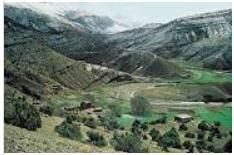
Long depression which is surrounded by high grounds is classified as- a)plain
- b)valley
- c)hill
- d)plateau
Correct answer is option 'B'. Can you explain this answer?
Long depression which is surrounded by high grounds is classified as
a)
plain
b)
valley
c)
hill
d)
plateau
|
|
Varun Kapoor answered |
Long depression which is surrounded by high grounds is classified as a valley.
Third largest ocean of the world is
- a)Ocean of Antarctica
- b)Atlantic Ocean
- c)Arctic Ocean
- d)Indian Ocean
Correct answer is option 'D'. Can you explain this answer?
Third largest ocean of the world is
a)
Ocean of Antarctica
b)
Atlantic Ocean
c)
Arctic Ocean
d)
Indian Ocean
|
|
Akshita Sarkar answered |
The correct answer is option 'D', the Indian Ocean. Here is an explanation of why the Indian Ocean is the third largest ocean in the world:
Size of the Indian Ocean:
- The Indian Ocean covers an area of about 27 million square miles, making it the third largest ocean in the world.
- It is bounded by Africa on the west, Asia on the north, and Australia on the east.
Extent and Borders:
- The Indian Ocean extends from the southern coast of Australia to the southeastern coast of Africa and the Arabian Peninsula.
- It is connected to the Atlantic Ocean through the Southern Ocean and the Indian Ocean's southern boundary, which is formed by the continent of Antarctica.
- The Indian Ocean is also connected to the Pacific Ocean through the Indonesian Archipelago.
Key Features and Characteristics:
1. Tectonic Activity: The Indian Ocean is characterized by significant tectonic activity, including the presence of the Indian Ocean Ridge, a submarine mountain range that extends across the ocean floor.
2. Diverse Marine Life: The Indian Ocean is home to a rich and diverse array of marine life, including coral reefs, tropical fish, dolphins, whales, and various species of marine mammals.
3. Monsoon Winds: The Indian Ocean is influenced by the monsoon winds, which bring seasonal changes in weather patterns and play a crucial role in the region's climate.
4. Trade Routes: The Indian Ocean has been an important trade route for centuries, connecting Africa, Asia, and the Middle East. It has facilitated trade, cultural exchange, and interactions between different civilizations.
5. Natural Resources: The Indian Ocean is rich in natural resources, including oil, natural gas, minerals, and fish stocks, which contribute to the economic development of the countries bordering the ocean.
Conclusion:
In conclusion, the Indian Ocean is the third largest ocean in the world, covering a vast area and playing a significant role in global trade, climate patterns, and marine biodiversity. Its diverse features and resources make it an important and dynamic part of the Earth's oceans.
Which of the following countries does not have a coastline with Arabian Sea?- a)Afghanistan
- b)Pakistan
- c)Oman
- d)Iran
Correct answer is option 'A'. Can you explain this answer?
Which of the following countries does not have a coastline with Arabian Sea?
a)
Afghanistan
b)
Pakistan
c)
Oman
d)
Iran
|
|
Anita Menon answered |
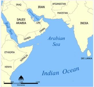
Afghanistan does not have a coastline with the Arabian Sea.
Extensive stretched piece of land is classified as- a)hill
- b)pateau
- c)plain
- d)valley
Correct answer is option 'C'. Can you explain this answer?
Extensive stretched piece of land is classified as
a)
hill
b)
pateau
c)
plain
d)
valley
|
|
Saikat Mehta answered |
Plain
A plain is an extensive stretched piece of land that is generally flat or gently rolling with no significant changes in elevation. It is one of the major landforms found on Earth's surface and covers a large portion of the land area.
Characteristics of a Plain:
1. Flat or gently rolling: Plains are characterized by their relatively flat or gently rolling terrain. They do not have steep slopes or significant changes in elevation.
2. Low-lying: Plains are usually located at lower altitudes compared to other landforms such as mountains or plateaus. They are often found in coastal areas or in the interior regions of continents.
3. Fertile soil: Plains are often formed by the accumulation of sediment carried by rivers and deposited over time. This deposition process creates a layer of fertile soil, making plains ideal for agriculture.
4. Lack of natural barriers: Plains typically lack natural barriers such as mountains or hills, which allows for easy movement and transportation. This makes plains suitable for human settlements and the development of infrastructure.
Examples of Plains:
1. Great Plains: The Great Plains of North America is a vast expanse of flat land that stretches across several states, including Kansas, Nebraska, and South Dakota. It is known for its fertile soil and is a major agricultural region.
2. Indo-Gangetic Plain: The Indo-Gangetic Plain is a large plain in South Asia, covering parts of India, Pakistan, and Bangladesh. It is one of the most densely populated regions in the world and is known for its rich agricultural productivity.
3. Pampas: The Pampas is a vast plain in South America, primarily located in Argentina and Uruguay. It is characterized by its grassy vegetation and is used for extensive cattle grazing.
Conclusion:
An extensive stretched piece of land is classified as a plain. Plains are flat or gently rolling landforms with fertile soil and lack significant changes in elevation. They are important for agriculture, human settlements, and transportation due to their favorable characteristics.
Second largest ocean of the world in terms of area is- a)Pacific Ocean
- b)Arctic Ocean
- c)Atlantic Ocean
- d)Southern Ocean
Correct answer is option 'C'. Can you explain this answer?
Second largest ocean of the world in terms of area is
a)
Pacific Ocean
b)
Arctic Ocean
c)
Atlantic Ocean
d)
Southern Ocean
|
|
Sarita Singh answered |
The Atlantic Ocean is the second largest ocean in the world whereas the Pacific Ocean is the largest.
Which country's flag is red with a white crescent and star?- a)Saudi Arabia
- b)Pakistan
- c)Malaysia
- d)Turkey
Correct answer is option 'D'. Can you explain this answer?
Which country's flag is red with a white crescent and star?
a)
Saudi Arabia
b)
Pakistan
c)
Malaysia
d)
Turkey
|
|
Ravi dey answered |
Flag with Red, White Crescent, and Star: Turkey
Turkey's flag is red with a white crescent and star symbol. Let's delve into the details of Turkey's flag:
Meaning of the Flag:
- The red color on the flag represents the blood shed by those who fought for Turkey's independence.
- The white crescent and star are symbols of Islam, the predominant religion in Turkey.
Historical Significance:
- The current design of the Turkish flag dates back to the 19th century during the Ottoman Empire.
- The red color was chosen to represent the blood of the martyrs who fought for the country's independence.
Symbolism of the Crescent and Star:
- The crescent and star have been used as symbols of Islam for centuries.
- In the context of the Turkish flag, they represent the country's cultural and religious heritage.
Usage of the Flag:
- The Turkish flag is flown on public buildings, schools, and during national holidays.
- It is a symbol of national pride and unity for the Turkish people.
In conclusion, the red flag with a white crescent and star belongs to Turkey and holds deep historical and cultural significance for the country and its people.
Which ocean is the smallest in the world?- a)Indian Ocean
- b)Atlantic Ocean
- c)Pacific Ocean
- d)Arctic Ocean
Correct answer is option 'D'. Can you explain this answer?
Which ocean is the smallest in the world?
a)
Indian Ocean
b)
Atlantic Ocean
c)
Pacific Ocean
d)
Arctic Ocean
|
|
Sandhya sharma answered |
Arctic Ocean is the smallest ocean in the world
The Arctic Ocean is the smallest and shallowest of the world's five major oceans. It is located in the Northern Hemisphere and is almost completely surrounded by Eurasia and North America. Here are some key points explaining why the Arctic Ocean is the smallest:
Size
- The Arctic Ocean covers an area of about 5.4 million square miles, making it the smallest of the five major oceans.
- It is significantly smaller than the other oceans such as the Pacific, Atlantic, and Indian Oceans.
Shallowness
- The average depth of the Arctic Ocean is around 3,953 feet, making it the shallowest of all the oceans.
- Its shallow depth is due to the presence of the continental shelves that surround it.
Location
- The Arctic Ocean is located primarily in the Arctic region and is bordered by various countries including Russia, Canada, Norway, the United States, and Greenland.
- It is partially covered by sea ice throughout the year, which further limits its size compared to other oceans.
In conclusion, the Arctic Ocean's smaller size and shallowness distinguish it from the other major oceans, making it the smallest ocean in the world.
Which country's flag is a maple leaf?- a)Canada
- b)Japan
- c)Brazil
- d)India
Correct answer is option 'A'. Can you explain this answer?
Which country's flag is a maple leaf?
a)
Canada
b)
Japan
c)
Brazil
d)
India
|
|
Aditi Sharma answered |
The flag of Canada, also known as the Maple Leaf flag, was adopted in 1965.
Which of the following is not matched correctly?- a)North America: Missourie River
- b)Asia: Mekong
- c)Africa: Zaire
- d)South America: Colorado
Correct answer is option 'D'. Can you explain this answer?
Which of the following is not matched correctly?
a)
North America: Missourie River
b)
Asia: Mekong
c)
Africa: Zaire
d)
South America: Colorado
|
|
Anita Menon answered |
The Colorado River is one of the principal rivers in the Southwestern United States and northern Mexico.
Consider the following statements regarding the climate of Sahara desert?- a)The climate of Sahara desert is scorching hot and dry.
- b)The sky is cloudless and clear.
- c)It receives plenty of rainfall.
- d)The nights may be freezing cold with temperatures nearing zero degrees.
Correct answer is option 'C'. Can you explain this answer?
Consider the following statements regarding the climate of Sahara desert?
a)
The climate of Sahara desert is scorching hot and dry.
b)
The sky is cloudless and clear.
c)
It receives plenty of rainfall.
d)
The nights may be freezing cold with temperatures nearing zero degrees.
|
|
Varun Kapoor answered |
The Sahara is dominated by two climatic regimes: a dry subtropical climate in the north and a dry tropical climate in the south. The dry subtropical climate is characterized by unusually high annual and diurnal temperature ranges, cold to cool winters and hot summers, and two precipitation maximums.
Large landforms that steeply rise above surroundings is called a- a)mountain
- b)folding
- c)plateau
- d)hill
Correct answer is option 'A'. Can you explain this answer?
Large landforms that steeply rise above surroundings is called a
a)
mountain
b)
folding
c)
plateau
d)
hill
|
|
Sarita Singh answered |
Large landforms that steeply rise above surroundings are called mountains.
Which continent is home to the Amazon rainforest?- a)Africa
- b)South America
- c)North America
- d)Europe
Correct answer is option 'B'. Can you explain this answer?
Which continent is home to the Amazon rainforest?
a)
Africa
b)
South America
c)
North America
d)
Europe
|
|
Ravi dey answered |
The Amazon rainforest is located in South America, specifically in the northern part of the continent. It covers a vast area, spanning across nine countries including Brazil, Peru, Colombia, Venezuela, Ecuador, Bolivia, Guyana, Suriname, and French Guiana. Here is a detailed explanation of why the correct answer is option 'B'.
- The Amazon Rainforest: The Amazon rainforest is the largest tropical rainforest in the world, covering an area of approximately 5.5 million square kilometers. It is often referred to as the "lungs of the Earth" due to its crucial role in producing oxygen and absorbing carbon dioxide. The rainforest is known for its immense biodiversity, with millions of plant and animal species residing within its borders.
- South America: South America is the correct answer because it is the continent that encompasses the Amazon rainforest. It is the fourth largest continent, located primarily in the Southern Hemisphere, and is bordered by the Atlantic Ocean to the east and the Pacific Ocean to the west. South America is home to various geographical features, including the Andes Mountains, the Amazon River, and the Amazon rainforest.
- Countries in South America: The Amazon rainforest stretches across multiple countries in South America. Brazil holds the largest portion of the rainforest, with approximately 60% of its area falling within its borders. Peru is the second-largest contributor, followed by Colombia, Venezuela, Ecuador, Bolivia, Guyana, Suriname, and French Guiana.
- Importance of the Amazon Rainforest: The Amazon rainforest plays a vital role in global climate regulation and biodiversity conservation. It serves as a carbon sink, absorbing a significant amount of carbon dioxide from the atmosphere, and helps to mitigate climate change. The region is also home to numerous indigenous communities, whose cultures and livelihoods are deeply intertwined with the rainforest.
- Threats to the Amazon Rainforest: Despite its ecological importance, the Amazon rainforest faces numerous threats, including deforestation, illegal logging, mining, and climate change. These activities contribute to the loss of biodiversity, habitat destruction, and the release of carbon dioxide into the atmosphere.
In conclusion, the Amazon rainforest is located in South America, making option 'B' the correct answer. Its vast size and ecological significance make it a crucial natural resource for the planet. It is essential to raise awareness and take measures to protect and sustainably manage this unique ecosystem.
Which chain of mountains divides the Soviet Union into the European and Asiatic region?
- a)Finland
- b)Sweden
- c)Denmark
- d)Russia (Urals)
Correct answer is option 'D'. Can you explain this answer?
Which chain of mountains divides the Soviet Union into the European and Asiatic region?
a)
Finland
b)
Sweden
c)
Denmark
d)
Russia (Urals)
|
|
Sarita Singh answered |
Norway divides the Soviet Union into the European and Asiatic regions.
The Scandinavian Mountains or the Scandes is a mountain range that runs through the Scandinavian Peninsula. The western sides of the mountains drop precipitously into the North Sea and the Norwegian Sea, forming the fjords of Norway, whereas to the northeast they gradually curve towards Finland.
The Scandinavian Mountains or the Scandes is a mountain range that runs through the Scandinavian Peninsula. The western sides of the mountains drop precipitously into the North Sea and the Norwegian Sea, forming the fjords of Norway, whereas to the northeast they gradually curve towards Finland.
These are found in dry deserts. Most of these are located in the western margins of the continents. The vegetation cover is scarce here because of scanty rain and scorching heat. Which of the following vegetation is this?- a)Tundra vegetation
- b)Thorny bushes
- c)Temperate grasslands
- d)Tropical grasslands
Correct answer is option 'B'. Can you explain this answer?
These are found in dry deserts. Most of these are located in the western margins of the continents. The vegetation cover is scarce here because of scanty rain and scorching heat. Which of the following vegetation is this?
a)
Tundra vegetation
b)
Thorny bushes
c)
Temperate grasslands
d)
Tropical grasslands
|
|
Varun Kapoor answered |
Thorny bushes: These are found in the dry desert like regions. Tropical deserts are located on the western margins of the continents. The vegetation cover is scarce here because of scanty rain and scorching heat.
The River Seine is situated in- a)Egypt
- b)France
- c)Poland
- d)None of these
Correct answer is option 'B'. Can you explain this answer?
The River Seine is situated in
a)
Egypt
b)
France
c)
Poland
d)
None of these
|
|
Sarita Singh answered |
The River Seine is situated in France. The Seine is a 777-kilometre-long river and an important commercial waterway within the Paris Basin in the north of France.
Which of the following is a carnivorous plant?- a)Cactus
- b)Sunflower
- c)Venus Flytrap
- d)Orchid
Correct answer is option 'C'. Can you explain this answer?
Which of the following is a carnivorous plant?
a)
Cactus
b)
Sunflower
c)
Venus Flytrap
d)
Orchid
|
|
Abhinav chandra answered |
Answer:
Carnivorous plants are unique types of plants that have adapted to obtain nutrients by trapping and digesting small insects and other organisms. They have evolved this mechanism due to the lack of nutrients, particularly nitrogen, in their natural habitats. One such carnivorous plant is the Venus Flytrap.
Venus Flytrap:
- The Venus Flytrap is a carnivorous plant native to the subtropical wetlands of the United States.
- It is a small plant with leaves that have modified into trapping mechanisms.
- The traps consist of two lobes with sensitive trigger hairs on the inner surface.
- When an insect or small organism touches the trigger hairs, the lobes snap shut, trapping the prey inside.
- The plant then secretes enzymes to digest the prey and absorb the nutrients.
- Venus Flytraps primarily feed on small insects, such as flies and spiders.
Other options:
a) Cactus: Cacti are not carnivorous plants. They are adapted to survive in arid environments and store water in their fleshy stems.
b) Sunflower: Sunflowers are not carnivorous plants. They belong to the family Asteraceae and are known for their large, showy flowers and edible seeds.
d) Orchid: Orchids are not carnivorous plants. They are a diverse family of flowering plants known for their beautiful and often fragrant flowers. Orchids obtain nutrients through their roots like most other plants.
Adaptations of carnivorous plants:
Carnivorous plants have developed various adaptations to capture and digest their prey. Some common adaptations include:
1. Trapping mechanisms: Plants like the Venus Flytrap have specialized leaves that form traps to catch prey. These traps may close rapidly or have sticky surfaces to prevent escape.
2. Digestive enzymes: Carnivorous plants produce enzymes that help break down the captured prey into simpler compounds that can be absorbed by the plant.
3. Modified leaves: The leaves of carnivorous plants have evolved to perform functions other than photosynthesis. They may have hairs or glands that secrete digestive enzymes or nectar to attract prey.
4. Reduced dependence on soil nutrients: Carnivorous plants have reduced their reliance on obtaining nutrients from the soil due to the lack of availability in their habitats. They have developed alternative ways to obtain nitrogen and other essential nutrients from insects and other prey.
In conclusion, the Venus Flytrap is a carnivorous plant that has evolved unique adaptations to capture and digest small insects as a source of nutrients.
Which country is famous for the Great Barrier Reef?- a)Brazil
- b)Australia
- c)Mexico
- d)Canada
Correct answer is option 'B'. Can you explain this answer?
Which country is famous for the Great Barrier Reef?
a)
Brazil
b)
Australia
c)
Mexico
d)
Canada
|
|
Aditi Sharma answered |
The Great Barrier Reef is the largest coral reef system in the world and is located off the coast of Australia.
Which type of landform is a large, flat area elevated above the surrounding land?- a)Mountain
- b)Hill
- c)Plateau
- d)Valley
Correct answer is option 'C'. Can you explain this answer?
Which type of landform is a large, flat area elevated above the surrounding land?
a)
Mountain
b)
Hill
c)
Plateau
d)
Valley
|
|
Aditi Sharma answered |
Plateaus are often formed by volcanic activity or uplift from tectonic forces.
Mt. Etna is an example of - a)Vulnerable volcanoes
- b)Active volcanoes
- c)Extinct volcanoes
- d)Dormant volcanoes
Correct answer is option 'B'. Can you explain this answer?
Mt. Etna is an example of
a)
Vulnerable volcanoes
b)
Active volcanoes
c)
Extinct volcanoes
d)
Dormant volcanoes
|
|
Arjun Yadav answered |
Active volcanoes
Active volcanoes are those that have erupted in recent history and are likely to erupt again in the future. They are characterized by ongoing volcanic activity, such as the release of gases, formation of lava flows, and occasional explosive eruptions. One example of an active volcano is Mt. Etna.
Mt. Etna
- Mt. Etna is located on the east coast of Sicily, Italy. It is one of the most active volcanoes in the world and has been erupting for thousands of years.
- It is a stratovolcano, which means it is composed of layers of hardened lava, ash, and other volcanic materials.
- Mt. Etna is the tallest active volcano in Europe, standing at approximately 3,350 meters (10,990 feet) high.
- It has a long history of eruptions, with the most recent one occurring in February 2021. These eruptions are often characterized by lava flows, ash emissions, and occasional explosive activity.
- The volcano is closely monitored by scientists who use various instruments to measure volcanic activity, such as seismic activity, gas emissions, and ground deformation.
- Mt. Etna is a popular tourist attraction, and visitors can explore its volcanic landscape and even hike to the summit. However, safety precautions must be taken due to the unpredictable nature of volcanic activity.
Conclusion
In conclusion, Mt. Etna is an example of an active volcano. Its ongoing volcanic activity and frequent eruptions classify it as an active volcano rather than being dormant, extinct, or vulnerable. It serves as a reminder of the dynamic nature of our planet and the potential hazards associated with volcanic activity.
Landform which is raised and is flat-surfaced is classified as- a)hill
- b)plateau
- c)plain
- d)valley
Correct answer is option 'B'. Can you explain this answer?
Landform which is raised and is flat-surfaced is classified as
a)
hill
b)
plateau
c)
plain
d)
valley
|
|
Sarita Singh answered |
A plateau is a flat, elevated landform that rises sharply above the surrounding area on at least one side. Plateaus occur on every continent and take up a third of the Earth's land.
Which animal is known for its long neck?- a)Kangaroo
- b)Elephant
- c)Giraffe
- d)Penguin
Correct answer is option 'C'. Can you explain this answer?
Which animal is known for its long neck?
a)
Kangaroo
b)
Elephant
c)
Giraffe
d)
Penguin
|
|
Aditi Sharma answered |
Giraffes are the tallest living land animals and have long necks to reach leaves on tall trees.
Which wonder of the world is located in Rio de Janeiro, Brazil?- a)Great Wall of China
- b)Christ the Redeemer
- c)Machu Picchu
- d)Petra
Correct answer is option 'B'. Can you explain this answer?
Which wonder of the world is located in Rio de Janeiro, Brazil?
a)
Great Wall of China
b)
Christ the Redeemer
c)
Machu Picchu
d)
Petra
|
|
Aditi Sharma answered |
Christ the Redeemer is a famous statue and a symbol of Christianity located atop the Corcovado Mountain.
Which of the following cities was known earlier as ‘Pearl of the Antilles?- a)Mumbia
- b)Cuba
- c)Manila
- d)Shangai
Correct answer is option 'B'. Can you explain this answer?
Which of the following cities was known earlier as ‘Pearl of the Antilles?
a)
Mumbia
b)
Cuba
c)
Manila
d)
Shangai
|
|
Anita Menon answered |
'Cuba city' is known as "Pearl of the Antilles".
Plateaus are also known as
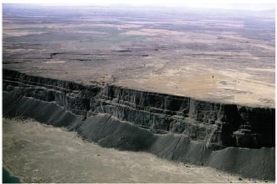
- a)flat-topped mountain
- b)table-land mountain
- c)piles of magma
- d)both (a) and (b)
Correct answer is option 'D'. Can you explain this answer?
Plateaus are also known as
a)
flat-topped mountain
b)
table-land mountain
c)
piles of magma
d)
both (a) and (b)
|
|
Anita Menon answered |
A plateau is an elevated area with a more or less levelled land on its top. It has a large area on its top and a steep slope on its sides. They are also called as high plains or tablelands. The plateaus cover about 18% of the earth's land surface.
The third biggest river of the world is- a)San Francisco
- b)Rio Grande
- c)Mississippi
- d)Ob
Correct answer is option 'C'. Can you explain this answer?
The third biggest river of the world is
a)
San Francisco
b)
Rio Grande
c)
Mississippi
d)
Ob
|
|
Sarita Singh answered |
The third biggest river of the world is Mississippi.
Shallowest and smallest ocean of world is- a)Northern Ocean
- b)Southern Ocean
- c)Arctic Ocean
- d)Antarctic Ocean
Correct answer is option 'C'. Can you explain this answer?
Shallowest and smallest ocean of world is
a)
Northern Ocean
b)
Southern Ocean
c)
Arctic Ocean
d)
Antarctic Ocean
|
|
Sarita Singh answered |
Shallowest and smallest Ocean of the world is Arctic Ocean.
Which country is known for the tulip fields?- a)Netherlands
- b)Turkey
- c)China
- d)Australia
Correct answer is option 'A'. Can you explain this answer?
Which country is known for the tulip fields?
a)
Netherlands
b)
Turkey
c)
China
d)
Australia
|
|
Aditi Sharma answered |
The Netherlands is famous for its vibrant tulip fields, particularly during the spring season.
Which country's capital is New Delhi?- a)India
- b)China
- c)Japan
- d)Australia
Correct answer is option 'A'. Can you explain this answer?
Which country's capital is New Delhi?
a)
India
b)
China
c)
Japan
d)
Australia
|
|
Aditi Sharma answered |
New Delhi is the capital of India and is known for its rich history and cultural heritage.
What is the capital of Jamaica?- a)Bridgetown
- b)Georgetown
- c)Port au Prince
- d)Kingston
Correct answer is option 'D'. Can you explain this answer?
What is the capital of Jamaica?
a)
Bridgetown
b)
Georgetown
c)
Port au Prince
d)
Kingston
|
|
Sarita Singh answered |
The capital of Jamaica is Kingston.
Which of the following is the smallest ocean of the world? (2015)- a)Pacific
- b)Indian
- c)Atlantic
- d)Arctic
Correct answer is option 'D'. Can you explain this answer?
Which of the following is the smallest ocean of the world? (2015)
a)
Pacific
b)
Indian
c)
Atlantic
d)
Arctic
|
|
Sarita Singh answered |
The Arctic Ocean is the smallest of the world’s five ocean basins. A polar bear walks on the frozen surface of the Arctic Ocean. The freezing environment provides a home for a diverse range of creatures.
Chapter doubts & questions for World Geography - GK Olympiad for Class 6 2025 is part of Class 6 exam preparation. The chapters have been prepared according to the Class 6 exam syllabus. The Chapter doubts & questions, notes, tests & MCQs are made for Class 6 2025 Exam. Find important definitions, questions, notes, meanings, examples, exercises, MCQs and online tests here.
Chapter doubts & questions of World Geography - GK Olympiad for Class 6 in English & Hindi are available as part of Class 6 exam.
Download more important topics, notes, lectures and mock test series for Class 6 Exam by signing up for free.
GK Olympiad for Class 6
39 videos|80 docs|102 tests
|
|
© EduRev
|
Education Revolution
|


|


Signup on EduRev and stay on top of your study goals
10M+ students crushing their study goals daily