


All Exams >
Humanities/Arts >
Geography Class 11 >
All Questions
All questions of Distribution of Oceans and Continents for Humanities/Arts Exam
The continental drift theory was propounded by- a)Alfred Wegner.
- b)Aortelius.
- c)Hall and Danna.
- d)Abraham Ortelius.
Correct answer is option 'A'. Can you explain this answer?
The continental drift theory was propounded by
a)
Alfred Wegner.
b)
Aortelius.
c)
Hall and Danna.
d)
Abraham Ortelius.
|
|
Anisha Singh answered |
Alfred Wegener—a German meteorologist put forth a comprehensive argument in the form of “the continental drift theory” in 1912.


The plate marked red colour in the world map is
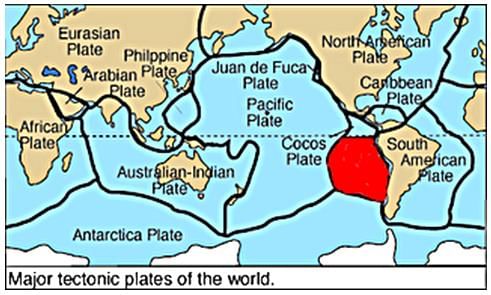
- a)Cocos plate.
- b)Nazca plate.
- c)Arabian plate.
- d)Philippine plate.
Correct answer is option 'B'. Can you explain this answer?
The plate marked red colour in the world map is
a)
Cocos plate.
b)
Nazca plate.
c)
Arabian plate.
d)
Philippine plate.

|
Kundan Redana answered |
TheThe Nazca Plate, or Nasca Plate , named after the Nazca region of southern Peru, is an oceanic tectonic plate in the eastern Pacific Ocean basin off the west coast of South America. The ongoing subduction, along the Peru–Chile Trench, of the Nazca Plate under the South American Plate is largely responsible for the Andean orogeny. The Nazca Plate is bounded on the west by the Pacific Plate and to the south by the Antarctic Plate through the East Pacific Rise and the Chile Rise respectively. The movement of the Nazca Plate over several hotspots has created some volcanic islands as well as east-west running seamount chains that subduct under South America. Nazca is a relatively young plate both in terms of the age of its rocks and its existence as an independent plate having been formed from the break-up of the Farallon Plate about 23 million years ago. The oldest rocks of the plate are about 50 million years old.
The boundary in the given picture shows the
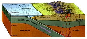
- a)divergent boundary.
- b)transform boundary.
- c)convergent boundary.
- d)oceanic boundary.
Correct answer is option 'C'. Can you explain this answer?
The boundary in the given picture shows the
a)
divergent boundary.
b)
transform boundary.
c)
convergent boundary.
d)
oceanic boundary.

|
Bharath Reddy Gundala answered |
When two plates collide (happens when move towards each other) only then subduction (one goes under another) happens which is why the case is convergent. Option C
Which of the following connects the continental shelf and the ocean basins?- a)Deep sea plains
- b)Continental slope
- c)Mid oceanic ridges
- d)None of these
Correct answer is option 'B'. Can you explain this answer?
Which of the following connects the continental shelf and the ocean basins?
a)
Deep sea plains
b)
Continental slope
c)
Mid oceanic ridges
d)
None of these

|
Learning Educators answered |
Continental Slope
- The continental slope connects the continental shelf and the ocean basins. Hence, the correct answer is Continental slope.
- It begins where the bottom of the continental shelf sharply drops off into a steep slope.
- The gradient of the slope region varies between 2-5°.
- The depth of the slope region varies between 200 and 3,000 m.
According to the Plate Tectonic concept, how many major plates are there?- a)7
- b)9
- c)12
- d)11
Correct answer is option 'A'. Can you explain this answer?
According to the Plate Tectonic concept, how many major plates are there?
a)
7
b)
9
c)
12
d)
11
|
|
Ashish Majumdar answered |
On Earth, there are seven major plates and many minor plates. Where plates meet, their relative motion determines the type of boundary; convergent, divergent, or transform.
Baghdad is the capital of
- a)Iran
- b)Burma
- c)Iraq
- d)Philippines
Correct answer is option 'C'. Can you explain this answer?
Baghdad is the capital of
a)
Iran
b)
Burma
c)
Iraq
d)
Philippines
|
|
Harshitha Basu answered |
The correct answer is b) Iraq.
Baghdad, the capital city of Iraq, is located in the central part of the country on the banks of the Tigris River. With a history dating back over a thousand years, Baghdad has served as the capital of various empires and has played a significant role in shaping the region's political, cultural, and economic landscape.
**Historical Significance of Baghdad:**
- The foundation of Baghdad can be traced back to the 8th century when it was established as the capital of the Abbasid Caliphate. This era marked the Golden Age of Islam, where the city became a center of learning, art, and science.
- During the reign of the Abbasid Caliphate, Baghdad flourished as a bustling metropolis, attracting scholars, philosophers, and traders from different parts of the world. It became renowned as a hub of intellectual and cultural exchange.
- Baghdad's strategic location on the Silk Road, an ancient trade route connecting Europe and Asia, contributed to its prosperity. The city became a major commercial center, facilitating trade between East and West.
**Modern Baghdad:**
- In the 20th century, Baghdad continued to grow and develop as the capital of Iraq. It witnessed significant urbanization and modernization, with the establishment of infrastructure, government institutions, and industries.
- However, Baghdad has also faced numerous challenges throughout its history. The city has been affected by various conflicts, including the Iran-Iraq War, the Gulf War, and the Iraq War. These conflicts have caused significant destruction and loss of life in the city.
- Despite the challenges, Baghdad remains an important cultural and political center in the Middle East. It is home to numerous historical sites, such as the famous Al-Mustansiriya School, the Abbasid Palace, and the famous Al-Mutanabbi Street, known for its vibrant book market.
**Conclusion:**
Baghdad's historical significance, cultural heritage, and political importance make it a crucial city in the Middle East. While options a) Iran, c) Burma, and d) Philippines have their own capitals, it is Iraq that is associated with Baghdad as its capital city.
The largest man-made canal in the world is the- a)Panama Canal
- b)Suez Canal
- c)Rhine Canal
- d)None of these
Correct answer is option 'B'. Can you explain this answer?
The largest man-made canal in the world is the
a)
Panama Canal
b)
Suez Canal
c)
Rhine Canal
d)
None of these
|
|
Upasana Chopra answered |
The largest man-made canal in the world is the Suez Canal.
Explanation:
The Suez Canal is an artificial waterway located in Egypt, connecting the Mediterranean Sea to the Red Sea. It was constructed to provide a shortcut for maritime trade between Europe and Asia, eliminating the need for ships to navigate around the Cape of Good Hope in Africa. The canal plays a crucial role in global trade, serving as a vital link between the Atlantic and Indian Oceans.
Here are some key points about the Suez Canal:
1. Length: The Suez Canal stretches for approximately 120 miles (193 kilometers), making it the longest man-made canal in the world. It was completed in 1869 after a decade of construction.
2. Importance: The canal serves as a major trade route, allowing ships to avoid the lengthy and hazardous journey around the southern tip of Africa. It significantly reduces travel time and costs for vessels traveling between Europe and Asia.
3. Economic significance: The Suez Canal is a vital artery for global trade and commerce. It facilitates the transportation of goods, including petroleum, natural gas, and various other commodities. The canal's strategic location makes it a crucial transit point for international shipping.
4. Expansion and improvements: Over the years, the Suez Canal has undergone several expansions and improvements to accommodate larger vessels and increase its capacity. Notable projects include the widening and deepening of certain sections to allow for the passage of larger ships.
5. Revenue and tolls: The Suez Canal generates significant revenue for Egypt through tolls charged on ships passing through the waterway. These tolls contribute to the country's economy and infrastructure development.
In conclusion, the Suez Canal is the largest man-made canal in the world, serving as a vital trade route between the Mediterranean Sea and the Red Sea. Its construction and strategic importance have greatly impacted global trade and maritime transportation.
A tectonic plate is a slab of- a)molten rock.
- b)hot rock.
- c)solid rock.
- d)small rocks.
Correct answer is option 'C'. Can you explain this answer?
A tectonic plate is a slab of
a)
molten rock.
b)
hot rock.
c)
solid rock.
d)
small rocks.
|
|
Suyash Saha answered |
A tectonic plate (also called lithospheric plate) is a massive, irregularly-shaped slab of solid rock, generally composed of both continental and oceanic lithosphere.
Tillite is formed due to- a)deposits on mountains.
- b)deposits of volcanoes.
- c)deposits of glaciers.
- d)deposits of gold.
Correct answer is option 'C'. Can you explain this answer?
Tillite is formed due to
a)
deposits on mountains.
b)
deposits of volcanoes.
c)
deposits of glaciers.
d)
deposits of gold.
|
|
Kavya Datta answered |
Formation of Tillite
Tillite is a type of sedimentary rock that is formed due to the deposition of glacial sediments. It is also known as glacial till or boulder clay.
Glaciers are large masses of ice that move slowly over the land. They are formed when snow accumulates in a particular area and does not melt completely. Over time, this snow gets compressed and turns into ice. As more and more snow accumulates on top of it, the ice mass grows larger and starts to move downhill due to its own weight.
As the glacier moves, it carries with it rocks, pebbles, sand, and other debris that get trapped in the ice. This mixture of ice and debris is known as glacial till.
When the glacier eventually melts, the sedimentary material that was carried by the glacier is left behind. This sedimentary material is called till or glacial till. It is a mixture of different-sized particles, ranging from large boulders to fine grains of sand.
Over time, this till gets compressed and cemented together to form tillite. Tillite is a type of sedimentary rock that is characterized by its distinctive layered appearance and its composition of glacial sediments.
Uses of Tillite
Tillite is used as a building material, as it is strong and durable. It is also used in the construction of roads and bridges, as it provides a stable base for these structures. Additionally, tillite is used in landscaping and gardening, as it provides a good drainage system for plants.
Conclusion
Tillite is a type of sedimentary rock that is formed due to the deposition of glacial sediments. It is a mixture of different-sized particles, ranging from large boulders to fine grains of sand. Tillite is a useful building material and is used in the construction of roads and bridges.
What is a tectonic plate that lies between the Asiatic and Pacific Plate?- a)Cocos Plate
- b)Nazca Plate
- c)Arabian Plate
- d)Philippine Plate
Correct answer is option 'D'. Can you explain this answer?
What is a tectonic plate that lies between the Asiatic and Pacific Plate?
a)
Cocos Plate
b)
Nazca Plate
c)
Arabian Plate
d)
Philippine Plate
|
|
Prasad Chatterjee answered |
The Philippine Plate is an oceanic tectonic plate, between the Pacific Ocean to the east and Asiatic plate on the west.
The slowest rate of plate movement can be seen in- a)East Pacific region.
- b)Arctic ridge.
- c)South pacific region.
- d)Mid Atlantic ridge.
Correct answer is option 'B'. Can you explain this answer?
The slowest rate of plate movement can be seen in
a)
East Pacific region.
b)
Arctic ridge.
c)
South pacific region.
d)
Mid Atlantic ridge.
|
|
Priya Mukherjee answered |
The slowest rate of plate movement can be seen in Artic ridge. It is less than 2.5 cm/yr.
A volume of seawater equal to the volume of the oceans cycles through submarine hydrothermal systems roughly every _________.
- a)year
- b)5,000 years
- c)10 million years
- d)one billion years
Correct answer is option 'C'. Can you explain this answer?
A volume of seawater equal to the volume of the oceans cycles through submarine hydrothermal systems roughly every _________.
a)
year
b)
5,000 years
c)
10 million years
d)
one billion years
|
|
Prashanth Goyal answered |
Explanation:
Submarine hydrothermal systems are underwater geological structures where hot fluids and minerals are released into the ocean from beneath the Earth's crust. These systems play a crucial role in the chemical and physical processes occurring in the oceans. The volume of water that cycles through these systems is equal to the volume of the oceans.
The volume of the oceans:
The total volume of the oceans on Earth is estimated to be approximately 1.332 billion cubic kilometers (km³). This volume includes all the interconnected bodies of saltwater, including the Atlantic, Pacific, Indian, Southern, and Arctic Oceans.
Cycling of seawater through submarine hydrothermal systems:
Seawater continuously circulates through submarine hydrothermal systems, driven by various geological processes. These systems are commonly found along mid-ocean ridges, where tectonic plates spread apart, creating fractures and vents through which hot fluids and minerals are released.
The rate at which seawater cycles through these systems is influenced by several factors, but on average, it is estimated that the entire volume of the oceans cycles through submarine hydrothermal systems roughly every 10 million years.
Importance of submarine hydrothermal systems:
Submarine hydrothermal systems play a crucial role in the oceanic ecosystem and have significant implications for global biogeochemical cycles. They release large amounts of heat, dissolved gases, and chemical elements into the surrounding seawater, creating unique habitats for diverse microbial communities and supporting chemosynthetic ecosystems.
Additionally, the minerals and metals deposited by these systems contribute to the formation of massive sulfide deposits on the seafloor, which are potential sources of valuable resources such as copper, zinc, and gold.
Conclusion:
In summary, the volume of seawater equal to the volume of the oceans cycles through submarine hydrothermal systems roughly every 10 million years. These systems are important for their role in oceanic processes, the formation of unique ecosystems, and the potential extraction of valuable mineral resources.
Grenada is situated in the- a)Pacific Ocean
- b)Indian Ocean
- c)Caribbean Sea
- d)Mediterranean Sea
Correct answer is option 'C'. Can you explain this answer?
Grenada is situated in the
a)
Pacific Ocean
b)
Indian Ocean
c)
Caribbean Sea
d)
Mediterranean Sea
|
|
Parth Chatterjee answered |
Grenada is situated in the Caribbean Sea.
Location:
Grenada is a small island country located in the southeastern Caribbean Sea. It is situated at the southern end of the Grenadines, a chain of islands that stretches between the Caribbean Sea and the Atlantic Ocean. Grenada is part of the Lesser Antilles, a group of islands in the Caribbean Sea.
Geographical Features:
Grenada is made up of the main island of Grenada and several smaller islands, including Carriacou and Petite Martinique. The main island is known for its mountainous terrain, lush rainforests, and beautiful white-sand beaches. It is also home to several volcanic crater lakes, such as Grand Etang Lake.
Caribbean Sea:
The Caribbean Sea is a body of water located in the western part of the Atlantic Ocean. It is surrounded by several countries and island nations, including Grenada. The sea is renowned for its crystal-clear turquoise waters, vibrant coral reefs, and diverse marine life. It is a popular destination for tourists who enjoy activities such as snorkeling, scuba diving, and sailing.
Cultural Significance:
Grenada's location in the Caribbean Sea has greatly influenced its culture and history. The island has a rich Afro-Caribbean heritage, with influences from African, European, and indigenous Caribbean cultures. The local cuisine, music, and art reflect this diverse cultural mix. Grenada is also known for its annual carnival celebration, where locals and visitors come together to enjoy vibrant costumes, music, and dance.
Economy and Tourism:
The Caribbean Sea plays a significant role in Grenada's economy, particularly through tourism and fishing. The island's stunning beaches and natural beauty attract visitors from around the world, contributing to the tourism industry. Additionally, fishing is an important economic activity, with locals relying on the sea for their livelihoods.
Overall, Grenada's location in the Caribbean Sea not only provides it with breathtaking natural landscapes but also shapes its cultural identity and serves as a vital part of its economy.
A seamount is _________- a)a coral reef above a submerged volcano
- b)a small rise in the seafloor
- c)an extinct submerged volcano
- d)a hill adjacent to a spreading center
Correct answer is option 'C'. Can you explain this answer?
A seamount is _________
a)
a coral reef above a submerged volcano
b)
a small rise in the seafloor
c)
an extinct submerged volcano
d)
a hill adjacent to a spreading center
|
|
Sai Dey answered |
A seamount is an extinct submerged volcano. It is a geological feature that is formed by volcanic activity under the ocean. Seamounts are found in various parts of the world's oceans and play a significant role in the geology and ecology of the marine environment.
Explanation:
Formation of Seamounts:
- Seamounts are formed through volcanic activity on the ocean floor. When a volcano erupts underwater, it releases lava, gases, and other materials into the surrounding water. Over time, these volcanic materials build up and form a cone-shaped mountain.
- As the volcano continues to erupt and the lava flows, the seamount grows higher. However, once the volcanic activity ceases, the seamount becomes dormant and eventually extinct.
- Seamounts can vary in size and shape, ranging from small rises on the seafloor to enormous underwater mountains.
Characteristics of Seamounts:
- Seamounts are typically characterized by a conical or dome-shaped structure. The shape of a seamount depends on factors such as the rate of volcanic activity, the composition of lava, and the presence of other geological features.
- They can have a wide range of heights, with some seamounts reaching near the surface of the ocean, while others remain deep beneath the water.
- Seamounts are usually isolated features, although they can sometimes occur in clusters or chains, particularly near tectonic plate boundaries and hotspots.
- Seamounts are often associated with other geological features such as guyots, which are flat-topped seamounts that have eroded over time.
Importance of Seamounts:
- Seamounts are important for various reasons, including their role in the geology and ecology of the ocean. They provide habitats for a diverse range of marine organisms, including corals, sponges, and fish.
- Due to the upward flow of nutrient-rich water around seamounts, they attract a variety of marine life, making them biodiversity hotspots.
- Seamounts also have the potential to influence ocean currents and water circulation patterns, as their shape can create turbulence and eddies in the surrounding water.
- Additionally, seamounts have economic significance as potential sources of mineral resources, including metals and rare minerals.
Conclusion:
In summary, a seamount is an extinct submerged volcano that is formed through volcanic activity on the ocean floor. It is characterized by a conical or dome-shaped structure and provides important habitats for marine life. Seamounts play a significant role in the geology and ecology of the ocean and have potential economic value.
By which method have facilitated correlating the rock formation from different continents across oceans?- a)The radiometric dating methods
- b)Carbon 14 method
- c)Radioactive methods
- d)Fling method
Correct answer is option 'A'. Can you explain this answer?
By which method have facilitated correlating the rock formation from different continents across oceans?
a)
The radiometric dating methods
b)
Carbon 14 method
c)
Radioactive methods
d)
Fling method
|
|
Aniket Banerjee answered |
The method that has facilitated correlating the rock formation from different continents across oceans is the radiometric dating method.
Radiometric dating is a technique used to determine the age of rocks and minerals based on the decay of radioactive isotopes. It relies on the fact that certain isotopes are unstable and decay over time into more stable forms at a known rate. By measuring the ratio of parent isotopes to daughter isotopes in a sample, scientists can calculate how long it has been since the rock formed.
There are several types of radiometric dating methods, but two commonly used in geology are uranium-lead dating and potassium-argon dating. Uranium-lead dating is particularly useful for dating rocks that are billions of years old, while potassium-argon dating is used for rocks that are hundreds of thousands to millions of years old.
By applying radiometric dating to rocks from different continents, scientists can determine their ages and compare them to see if they formed at the same time. If rocks from two different continents have the same age, it suggests that they were once connected and have since drifted apart due to plate tectonics.
For example, the discovery of matching rock formations and fossils on the east coast of South America and the west coast of Africa provided crucial evidence for the theory of continental drift. These continents were once part of a supercontinent called Pangaea, which began to break apart around 200 million years ago. The radiometric dating of rocks on both continents helped confirm this hypothesis.
In summary, the radiometric dating method has been instrumental in correlating rock formations from different continents across oceans. By determining the ages of rocks using radioactive isotopes, scientists can establish connections between continents and provide evidence for plate tectonics and continental drift.
The southern continent broken from pangaea is- a)Laurasia
- b)Gondwanaland
- c)Pacific ocean
- d)none of them
Correct answer is option 'B'. Can you explain this answer?
The southern continent broken from pangaea is
a)
Laurasia
b)
Gondwanaland
c)
Pacific ocean
d)
none of them
|
|
Athul Ghosh answered |
The Southern Continent Broken from Pangaea is Gondwanaland
Gondwanaland is the correct answer to the question. Let's break down the answer in detail:
1. Introduction:
The supercontinent Pangaea, which existed about 300 million years ago, is believed to have split into two major landmasses during the Mesozoic era. The northern landmass was called Laurasia, and the southern landmass was known as Gondwanaland.
2. Formation of Gondwanaland:
During the Triassic period, Pangaea began to break apart due to tectonic activity. Gondwanaland gradually separated from the northern portion of Pangaea, Laurasia, and started drifting towards the South Pole.
3. Composition of Gondwanaland:
Gondwanaland comprised several present-day continents, including South America, Africa, Antarctica, Australia, and the Indian subcontinent. These landmasses were once interconnected, forming a vast southern supercontinent.
4. Geological Evidence:
Geological evidence supports the existence and breakup of Gondwanaland. Fossil records and geological formations found across these continents provide clues about their ancient connection. For example, Mesosaurus, a freshwater reptile, was found in both South America and South Africa, suggesting a shared ancient environment.
5. Separation and Drift:
As Gondwanaland began to separate, it started drifting in different directions due to plate tectonics. Over millions of years, the landmasses moved apart, forming the continents we see today. The Indian subcontinent, for instance, drifted northward and collided with the Eurasian plate, giving rise to the formation of the Himalayas.
6. Modern-Day Continents:
The breakup of Gondwanaland resulted in the formation of the modern-day continents mentioned earlier. South America and Africa still show geological similarities, such as similar rock formations and the presence of ancient mountain belts that align when the continents are brought together.
Conclusion:
In summary, the southern continent that broke away from Pangaea is known as Gondwanaland. It consisted of South America, Africa, Antarctica, Australia, and the Indian subcontinent. The breakup of Gondwanaland played a significant role in shaping the modern-day continents we see today, and the geological evidence supports this ancient supercontinent's existence.
When a wave gets close to shore, water particles near the bottom move in ______ orbits.- a)circular
- b)elliptical
- c)irregular
- d)rectangular
Correct answer is option 'B'. Can you explain this answer?
When a wave gets close to shore, water particles near the bottom move in ______ orbits.
a)
circular
b)
elliptical
c)
irregular
d)
rectangular
|
|
Priyanka Chavan answered |
Explanation:
When a wave approaches the shore, it undergoes a process called wave shoaling, where the wave height increases and the wave length decreases. This is because the bottom of the wave starts to interact with the ocean floor as the water depth decreases towards the shore. As a result, the water particles near the bottom of the wave move in elliptical orbits.
Elliptical Orbits:
Elliptical orbits are characterized by an oval shape, with the water particles moving in a circular motion at the surface and a more elongated motion near the bottom. The motion of the water particles becomes more elliptical as the wave approaches the shore and the water depth decreases.
Factors influencing elliptical orbits:
Several factors influence the shape of the orbits:
1. Wave Height: As the wave height increases near the shore, the orbits become more elliptical. This is because the wave interacts more with the ocean floor, causing the water particles near the bottom to move in a more elongated path.
2. Water Depth: The shallower the water depth, the more elliptical the orbits become. In deep water, the wave motion is primarily determined by the wave speed and wavelength. However, as the water depth decreases towards the shore, the orbits become more influenced by the ocean floor, resulting in elliptical orbits.
3. Wave Period: The time it takes for a wave to complete one full cycle, known as the wave period, also affects the shape of the orbits. Waves with longer periods tend to have more circular orbits, while waves with shorter periods have more elliptical orbits.
Conclusion:
In summary, when a wave gets close to the shore, water particles near the bottom move in elliptical orbits. This is due to the interaction between the wave and the ocean floor as the water depth decreases towards the shore. The factors influencing the shape of the orbits include wave height, water depth, and wave period. It is important to understand these orbital patterns to study the behavior of waves and their impact on coastal areas.
The shells of diatoms and radiolaria, which accumulate on the abyssal plain, are composed of ____________ .- a)calcium carbonate
- b)sodium chloride
- c)iron sulfide
- d)silica
Correct answer is option 'D'. Can you explain this answer?
The shells of diatoms and radiolaria, which accumulate on the abyssal plain, are composed of ____________ .
a)
calcium carbonate
b)
sodium chloride
c)
iron sulfide
d)
silica
|
|
Mainak Goyal answered |
The correct answer is option 'D': silica.
Diatoms and radiolaria are microscopic marine organisms that are part of the plankton community. They are single-celled organisms that have a protective outer shell, or test, made of various materials. These shells accumulate on the abyssal plain, which is the flat and sediment-covered seafloor found in the deepest parts of the ocean.
1. Diatoms and Radiolaria:
- Diatoms are a type of phytoplankton, which are photosynthetic microorganisms that form the base of the marine food chain.
- Radiolaria are zooplankton, which are heterotrophic organisms that consume other organisms or organic material.
- Both diatoms and radiolaria play important roles in marine ecosystems, as they are a food source for many larger organisms and help in carbon fixation.
2. Composition of Shells:
- The shells, or tests, of diatoms and radiolaria are made of different materials depending on the species.
- Diatoms have shells composed of silica, specifically hydrated silicon dioxide (SiO2·nH2O).
- Radiolaria also have shells made of silica, but they often have intricate and delicate structures due to their radial symmetry.
3. Silica:
- Silica is a compound that is abundant in the Earth's crust and can be found in various forms, such as quartz and sand.
- It is a hard and chemically stable material, making it suitable for the protective shells of diatoms and radiolaria.
- Silica is produced by these organisms through the uptake of dissolved silica from the surrounding seawater, which is then used to build their shells.
4. Accumulation on the Abyssal Plain:
- The abyssal plain is a vast, flat area of the seafloor found in the deepest parts of the ocean.
- The shells of diatoms and radiolaria sink to the bottom of the ocean after the organisms die, creating a layer of sediment on the abyssal plain.
- Over time, this accumulation of shells and other organic matter forms a thick layer of fine-grained sediment known as ooze.
In conclusion, the shells of diatoms and radiolaria, which accumulate on the abyssal plain, are composed of silica. Silica is a hard and chemically stable material that is produced by these organisms and provides protection for their single-celled bodies.
The largest producer of manganese in the world is- a)China
- b)India
- c)U.S.S.R.
- d)U.S.A.
Correct answer is option 'B'. Can you explain this answer?
The largest producer of manganese in the world is
a)
China
b)
India
c)
U.S.S.R.
d)
U.S.A.
|
|
Ishani Gupta answered |
The largest producer of manganese in the world is India.
Manganese is an essential metal used in various industries such as steel production, batteries, and chemical manufacturing. It is primarily used as an alloying element in steel to improve its strength, hardness, and resistance to corrosion.
India's Dominance in Manganese Production
India has emerged as the largest producer of manganese in the world due to several favorable factors:
1. Abundant Reserves: India is blessed with significant manganese ore reserves, particularly in the states of Odisha, Madhya Pradesh, and Karnataka. These reserves account for a substantial portion of the global manganese resources.
2. Mining Infrastructure: India has well-established mining infrastructure, including large-scale mines and processing plants. This enables efficient extraction and processing of manganese ore, contributing to the country's high production capacity.
3. Growing Demand: The demand for manganese has been steadily increasing due to the expansion of various industries, particularly steel production. India's robust domestic steel industry, which is one of the largest globally, is a major consumer of manganese, further driving its production.
4. Government Policies: The Indian government has implemented favorable policies and regulations to encourage the growth of the mining industry, including manganese production. These policies aim to attract investment, promote sustainable mining practices, and ensure the availability of essential minerals for domestic consumption.
5. Export Potential: India's abundant manganese reserves and high production capacity have also positioned the country as a significant exporter of manganese ore. It caters to the global demand, particularly from countries like China, Japan, South Korea, and the United States.
Conclusion
In conclusion, India is the largest producer of manganese in the world due to its abundant reserves, well-established mining infrastructure, growing demand from domestic industries, and favorable government policies. The country's dominance in manganese production has solidified its position as a major player in the global mining industry.
How many types of forces work on a moving plate?- a)Two
- b)Three
- c)Five
- d)Four
Correct answer is option 'A'. Can you explain this answer?
How many types of forces work on a moving plate?
a)
Two
b)
Three
c)
Five
d)
Four
|
|
Aniket Banerjee answered |
There are two types of forces that work on a moving plate: 1) Driving forces and 2) Resistive forces.
Driving Forces:
Driving forces are responsible for moving the plate. They are the forces that push or pull the plate in a particular direction. The two driving forces that work on a moving plate are:
1. Tectonic Forces:
Tectonic forces are generated by the movement of the Earth's tectonic plates. These forces are responsible for the motion of the plates and include tensional, compressional, and shear forces. Tensional forces occur when plates move away from each other, compressional forces occur when plates move towards each other, and shear forces occur when plates slide past each other.
2. Mantle Convection:
Mantle convection is another driving force that works on a moving plate. It is caused by the heat transfer in the Earth's mantle, which creates convection currents. These convection currents cause the motion of the tectonic plates above them. As the hot material rises and the cooler material sinks, it creates a circular motion that drives the plates.
Resistive Forces:
Resistive forces oppose the motion of the plate. They act in the opposite direction to the driving forces and slow down or stop the plate's motion. The two resistive forces that work on a moving plate are:
1. Friction:
Friction is the resistance to motion between two surfaces in contact. In the case of tectonic plates, friction occurs at plate boundaries where they interact with each other. Friction between plates can build up over time and resist the movement, eventually leading to earthquakes when the accumulated stress is released.
2. Inertia:
Inertia is the tendency of an object to resist changes in its motion. In the context of moving plates, inertia plays a role in resisting changes in their velocity or direction. The plates have mass, and according to Newton's first law of motion, they will continue to move at a constant velocity unless acted upon by an external force.
In conclusion, there are two types of forces that work on a moving plate: driving forces that move the plate and resistive forces that oppose its motion. The driving forces include tectonic forces and mantle convection, while the resistive forces include friction and inertia.
Chapter doubts & questions for Distribution of Oceans and Continents - Geography Class 11 2025 is part of Humanities/Arts exam preparation. The chapters have been prepared according to the Humanities/Arts exam syllabus. The Chapter doubts & questions, notes, tests & MCQs are made for Humanities/Arts 2025 Exam. Find important definitions, questions, notes, meanings, examples, exercises, MCQs and online tests here.
Chapter doubts & questions of Distribution of Oceans and Continents - Geography Class 11 in English & Hindi are available as part of Humanities/Arts exam.
Download more important topics, notes, lectures and mock test series for Humanities/Arts Exam by signing up for free.
Geography Class 11
70 videos|289 docs|44 tests
|
|
© EduRev
|
Education Revolution
|


|


Signup on EduRev and stay on top of your study goals
10M+ students crushing their study goals daily