Class 10 Exam > Class 10 Notes > Geography for GCSE/IGCSE > Coastal Landforms
Coastal Landforms | Geography for GCSE/IGCSE - Class 10 PDF Download
| Table of contents |
|
| Erosional Landforms |
|
| Headlands and bay |
|
| Caves, arches and stacks |
|
| Depositional Landforms |
|

Erosional Landforms
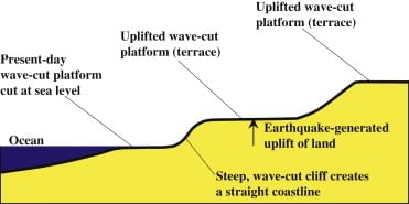
- Cliffs are formations of steep or gently sloping rocks, their profiles influenced by geological characteristics and surrounding topography.
- The angle of a cliff face is determined by geological factors and the intensity of wave erosion at its base, where high-energy waves are more destructive than low-energy ones.
- Many cliffs feature a 'knick-point' near the high-water mark, known as the 'wave-cut notch,' formed by wave undercutting.
- Abrasion, corrosion, and hydraulic action further erode the notch, extending it backward into the cliff.
- As undercutting persists, the cliff above becomes unsupported and unstable, eventually leading to collapse.
- The backwash of waves removes the eroded material, leaving behind a wave-cut platform.
- This process repeats, causing the cliff to continue retreating, resulting in coastal erosion.
The process of cliff retreat and wave-cut platform formation:
Headlands and bay
- These features are typically located in regions where layers of durable (hard) and less durable (soft) rocks alternate, creating a discordant coastline.Initially, erosion targets the less durable rock, such as clay, carving out a bay.
- A bay refers to a sea inlet where the land curves inward, often featuring a beach.
- Meanwhile, the more resilient rock, like limestone, remains projecting outward into the sea, forming a headland.
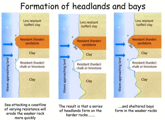
- A headland typically features cliffs along its sides, projects out to sea, is usually longer than it is wide, and consists of resistant rock.
- A bay usually has a wide, open entrance from the sea, a roughly semi-circular shape extending into the coastline, land that is lower than the surrounding headlands, and may or may not have a beach.
Question for Coastal LandformsTry yourself: What is the main factor that influences the angle of a cliff face?View Solution
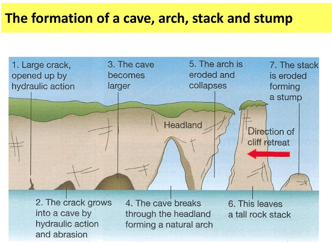
Caves, arches and stacks
- When waves approach the shore, their velocity decreases as they encounter the seabed.
- This alters the wave direction, causing the crests to align parallel to the coastline, a phenomenon known as wave refraction.
- Refraction concentrates erosive forces on all sides of the headland.
- Weaknesses in the headland are exploited by hydraulic action, abrasion, and corrosion.
- As cracks widen, abrasion begins to erode the forming cave.
- The cave expands over time, eventually breaking through the headland to create an arch.
- Erosion continues to widen and thin the arch's base, both from below by wave action and from above by weathering.
- Ultimately, the arch's roof collapses, leaving a solitary rock column known as a stack.
- The stack is undercut at its base by wave action and weathering from above until it crumbles, forming a stump.
Depositional Landforms
Beach
- Beaches typically form in protected areas like bays.
- Deposition takes place via constructive wave action, where the swash is stronger than the backwash.
- Beach formation commonly occurs during calmer summer months.
- Occasionally, strong winds may carry offshore sand onto the shore.
- This blown sand can accumulate and create sand dunes in the beach's backshore.
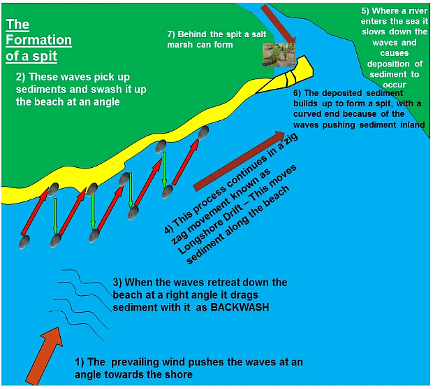
Spit
- A spit is an elongated strip of sand or shingle extending from the shoreline into the sea.
- Spit formation is triggered by changes in coastline shape or the presence of a river mouth, preventing a spit from forming across the estuary.
- The shape of a spit, including whether it has a curved end, depends on wind and current directions.
- A notable example is Spurn Point, which spans three and a half miles across the Humber Estuary in northeast England.
Formation Stages
- Sediment is transported by longshore drift along the coastline.
- When the coastline changes direction, shallow, sheltered areas facilitate sediment deposition.
- Increased friction leads to further deposition.
- Over time, a spit gradually builds up to sea level and extends.
- Changes in wind direction can alter wave patterns, resulting in a hooked end for the spit.
- The area behind the spit becomes sheltered, allowing for the deposition of silts that form salt marshes or mud flats.
Bar
- A bar occurs when a spit connects two headlands across a bay.
- It results in the formation of a sandbar, which can also develop offshore due to wave action.
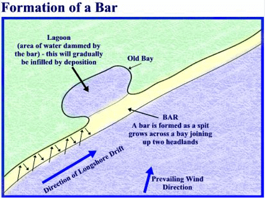
Lagoon
- A lagoon is a small body of water separated from the sea.
- It may form behind a bar or tombolo but is not permanent and can fill with sediment, creating new land.
Tombolo
- A tombolo forms when a spit connects the mainland to an island.
- An example is Chesil Beach in Dorset, which links the mainland to the Isle of Portland.
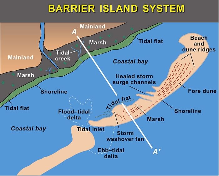
Barrier Island
- Barrier islands develop alongside the coast in a parallel formation.
- The primary distinction between a bar and a barrier island lies in their connectivity to the mainland and water bodies. A bar connects two headlands, while a barrier island is open at one or both ends.
Sand dunes
- Sand dunes are characterized by their dynamic nature, undergoing rapid changes.
- Typically, sandy beaches are accompanied by sand dunes, resulting from strong onshore winds carrying dried-out, exposed sand.
- Dunes are formed when sand grains are caught and deposited against obstacles like debris, rocks, or driftwood.
- Onshore winds push the seaward side of dune ridges towards the leeward side, causing them to move inland.
- The formation of sand dunes is facilitated by the interplay between winds and vegetation.
Formation of a sand dune
- Windblown sand accumulates against barriers such as pebbles or driftwood.
- With the capture of more sand particles, dunes expand, organizing into rows perpendicular to the prevailing wind direction.
- Over time, vegetation colonizes and stabilizes the ridges of the dunes through a process known as succession.
- Pioneer plant species, the first to establish, encounter challenges such as:
a. Salinity.
b. Scarce moisture due to rapid drainage of sand (high permeability).
c. Wind exposure.
d. Temporary burial by wind-blown sand.
e. Rising sea levels.
Embryo Dunes
- Wind-blown dry sand is trapped by debris, initiating deposition.
- Pioneer species like Lyme Grass and Sea Couch Grass start to establish.
- Soil content is minimal, and pH levels are high (alkaline).
- Embryo dunes are delicate and typically reach a maximum height of 1 meter.
Fore Dunes
- Embryo dunes provide some shelter from the prevailing wind.
- This allows for the growth of other plant species like Marram Grass.
- Marram grass begins to stabilize the dune with its root system.
- These plants contribute organic matter to the dunes, enhancing their suitability for subsequent plant growth.
- A microclimate forms in the dune slack.
- Fore dunes can reach a maximum height of 5 meters.
Yellow Dunes
- Initially, these dunes have a yellow hue which darkens over time as organic material enriches the soil.
- Marram grass remains dominant, but more delicate flowering plants and insects inhabit the dune slacks.
- Exposed sand decreases to 20% from an initial 80%.
- Maximum height does not exceed 8 meters.
Grey Dunes
- Grey dunes are more stable, with less than 10% of sand exposed, and exhibit greater biodiversity.
- Soil acidity and water content increase with the accumulation of humus.
- Shrubs and bushes start to appear.
- Height ranges from 8 to 10 meters.
Mature Dunes
- These are the oldest and most stable dunes, located several hundred meters or more from the shoreline.
- The soil can support diverse flora and fauna, including oak trees and alders, representing the climax vegetation.
- Mature dunes mark the final stage in succession, known as the climax community stage.
Question for Coastal LandformsTry yourself: What is the process by which a cave evolves into an arch?View Solution
The document Coastal Landforms | Geography for GCSE/IGCSE - Class 10 is a part of the Class 10 Course Geography for GCSE/IGCSE.
All you need of Class 10 at this link: Class 10
|
55 videos|68 docs|78 tests
|
FAQs on Coastal Landforms - Geography for GCSE/IGCSE - Class 10
| 1. What are erosional landforms formed by coastal processes? |  |
Ans. Erosional landforms formed by coastal processes include headlands and bays, caves, arches, and stacks.
| 2. What are some examples of depositional landforms found along coastlines? | |
Ans. Some examples of depositional landforms found along coastlines include beaches, spits, and barrier islands.
| 3. How do headlands and bays differ in terms of their formation and characteristics? | |
Ans. Headlands are formed when the sea erodes the land, creating a promontory that juts out into the water, while bays are indentations in the coastline where the sea has eroded the land behind a headland.
| 4. How are caves, arches, and stacks created along coastal areas? | |
Ans. Caves are formed by the erosion of weak areas in the rock by the action of waves, arches are created when a cave erodes through to the other side of a headland, and stacks are isolated columns of rock that are left behind as the coastline erodes.
| 5. What role does deposition play in shaping coastal landscapes? | |
Ans. Deposition plays a crucial role in shaping coastal landscapes by adding sediment to the coastline, creating features such as beaches, spits, and barrier islands.
About this Document

Oct 02, 2025
Last updated
Related Exams
Document Description: Coastal Landforms for Class 10 2025 is part of Geography for GCSE/IGCSE preparation.
The notes and questions for Coastal Landforms have been prepared according to the Class 10 exam syllabus. Information about Coastal Landforms covers topics
like Erosional Landforms, Headlands and bay, Caves, arches and stacks, Depositional Landforms and Coastal Landforms Example, for Class 10 2025 Exam. Find important definitions, questions, notes, meanings, examples, exercises and tests below for Coastal Landforms.
Introduction of Coastal Landforms in English is available as part of our Geography for GCSE/IGCSE
for Class 10 & Coastal Landforms in Hindi for Geography for GCSE/IGCSE course.
Download more important topics related with notes, lectures and mock test series for Class 10
Exam by signing up for free. Class 10: Coastal Landforms | Geography for GCSE/IGCSE - Class 10
Description
Full syllabus notes, lecture & questions for Coastal Landforms | Geography for GCSE/IGCSE - Class 10 - Class 10 | Plus excerises question with solution to help you revise complete syllabus for Geography for GCSE/IGCSE | Best notes, free PDF download
Information about Coastal Landforms
In this doc you can find the meaning of Coastal Landforms defined & explained in the simplest way possible. Besides explaining types of
Coastal Landforms theory, EduRev gives you an ample number of questions to practice Coastal Landforms tests, examples and also practice Class 10
tests

Related Searches
Free
,practice quizzes
,study material
,Coastal Landforms | Geography for GCSE/IGCSE - Class 10
,ppt
,MCQs
,Previous Year Questions with Solutions
,Sample Paper
,shortcuts and tricks
,Viva Questions
,Exam
,Coastal Landforms | Geography for GCSE/IGCSE - Class 10
,Summary
,Objective type Questions
,Semester Notes
,video lectures
,Important questions
,Extra Questions
,past year papers
,mock tests for examination
,Coastal Landforms | Geography for GCSE/IGCSE - Class 10
;


Additional Information about Coastal Landforms for Class 10 Preparation
Coastal Landforms Free PDF Download
The Coastal Landforms is an invaluable resource that delves deep into the core of the Class 10 exam.
These study notes are curated by experts and cover all the essential topics and concepts, making your preparation more efficient and effective.
With the help of these notes, you can grasp complex subjects quickly, revise important points easily,
and reinforce your understanding of key concepts. The study notes are presented in a concise and easy-to-understand manner,
allowing you to optimize your learning process. Whether you're looking for best-recommended books, sample papers, study material,
or toppers' notes, this PDF has got you covered. Download the Coastal Landforms now and kickstart your journey towards success in the Class 10 exam.
Importance of Coastal Landforms
The importance of Coastal Landforms cannot be overstated, especially for Class 10 aspirants.
This document holds the key to success in the Class 10 exam.
It offers a detailed understanding of the concept, providing invaluable insights into the topic.
By knowing the concepts well in advance, students can plan their preparation effectively.
Utilize this indispensable guide for a well-rounded preparation and achieve your desired results.
Coastal Landforms Notes
Coastal Landforms Notes offer in-depth insights into the specific topic to help you master it with ease.
This comprehensive document covers all aspects related to Coastal Landforms.
It includes detailed information about the exam syllabus, recommended books, and study materials for a well-rounded preparation.
Practice papers and question papers enable you to assess your progress effectively.
Additionally, the paper analysis provides valuable tips for tackling the exam strategically.
Access to Toppers' notes gives you an edge in understanding complex concepts.
Whether you're a beginner or aiming for advanced proficiency, Coastal Landforms Notes on EduRev are your ultimate resource for success.
Coastal Landforms Class 10 Questions
The "Coastal Landforms Class 10 Questions" guide is a valuable resource for all aspiring students preparing for the
Class 10 exam. It focuses on providing a wide range of practice questions to help students gauge
their understanding of the exam topics. These questions cover the entire syllabus, ensuring comprehensive preparation.
The guide includes previous years' question papers for students to familiarize themselves with the exam's format and difficulty level.
Additionally, it offers subject-specific question banks, allowing students to focus on weak areas and improve their performance.
Study Coastal Landforms on the App
Students of Class 10 can study Coastal Landforms alongwith tests & analysis from the EduRev app,
which will help them while preparing for their exam. Apart from the Coastal Landforms,
students can also utilize the EduRev App for other study materials such as previous year question papers, syllabus, important questions, etc.
The EduRev App will make your learning easier as you can access it from anywhere you want.
The content of Coastal Landforms is prepared as per the latest Class 10 syllabus.
|
© EduRev
|
Education Revolution
|


|


Signup to see your scores
go up within 7 days!
Access 1000+ FREE Docs, Videos and Tests
Takes less than 10 seconds to signup