Division of The Himalayas - UPSC PDF Download
Geographically, the entire Himalayan region can be divided into:
1. The Himalayan Ranges
2. The Trans Himalayas
3. The Eastern Hills
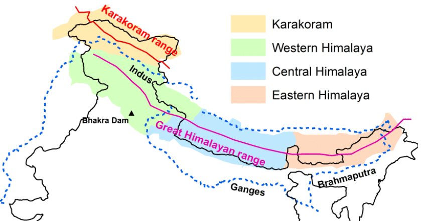
Mountain ranges in the Himalayan
region
1. The Himalayan Ranges
- The Himalayan ranges are a series of parallel ranges that are separated by deep valleys.
- As in all young fold mountains, we find a densely dissected “ridge-and valley-topography” in the Himalayas.
- Some prominent valleys include Valley of Kashmir and the Karewas, the Kangra and the Kulu valley in Himachal Pradesh, the Dun Valley, the Bhagirathi Valley (near Gangotri) and the Mandakini Valley in Nepal.
- The individual valleys have a steep gradient towards the south and a gentler slope towards the north.
- In the east, the Himalayas rise abruptly from the plains of Bengal and Awadh and suddenly attain greater elevation within a short distance from the foot of the mountains.
- Thus the peaks of Kanchenjunga and Everest are only a few kilometres from the plains and are visible from there.
- However, the western Himalayas rise gradually from the plains from the series of ranges.
(a) THE SHIVALIK RANGE
These comprise the outermost range of Himalayas and hence known as the Outer Himalayas. It has southern steep slopes and assumes a hogback appearance.
Its characteristic features include:
- Flat scarps
- Anticlinal crests
- Synclinal valleys etc.
The range runs almost parallel to the lesser Himalayas to about 2400 km. The width varies from 50kms in Himachal Pradesh to 15kms in Arunachal Pradesh. It is almost unbroken in succession except for a gap of 80 - 90kms which is occupied by the valley of Tista river. Altitude: 600 - 1500 mts.
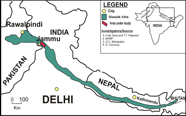
Shivalik Range
Formation
- They are formed of sands, gravel and conglomerates brought by the rivers flowing from the higher range of Himalayas.
- These had been folded and faulted by the Earth movements from the Middle Miocene to Lower Pleistocene ages. They were the last to form of all ranges.
- As they were formed after the formation of the Himalayas, they obstructed the course of rivers draining from the higher reaches of the Himalayas and formed temporary lakes.
- The debris brought by these rivers were deposited in these lakes. After the rivers cut through the Shiwaliks, the lakes drained away leaving behind plains called “duns” or “doons” in the west and “duar” in the east. Example : Dehradun in Uttarakhand.
- The Eastern part of the Shiwaliks has thick forest cover which is thin towards the west while the southern slopes are devoid of forest cover and are highly dissected by several seasonal streams locally known as Chos.
Different names of Shivalik are:
- Jammu Hills in Jammu
- Dafl, Miri, Abor, Mishmi Hills in Arunachal Pradesh
(b) THE MIDDLE OR LESSER HIMALAYA
- This lies between the Shiwaliks in the south and the Greater Himalayas in the north. It is also called Himachal or Lower Himalaya.
- Linear longitudinal ranges with steep, bare, southern slopes and more gentle, forest covered northern slopes. This gives a hogback look more pronounced than the Shiwaliks.
- Due to intensive compressive forces, the fold mountains of the Middle Himalayas are broken and not a continuous range.
- Important ranges include Pir Panjal (longest), Dhaola Dhar, the Mussoorie Range, the Nag Tiba and the Mahabharat Lekh. ( continuation of Mussoorie Range and is in southern Nepal)
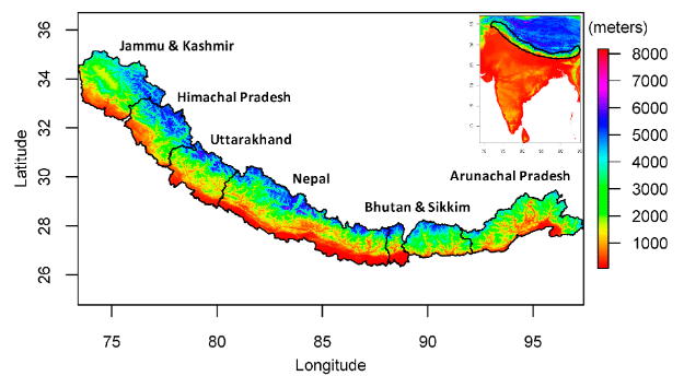
The Middle Himalayas (Green shaded
region)
(i) Pir Panjal
- The Pir Panjal range in Kashmir is the longest and the most important.
- Extends from Jhelum river to Beas river for 300-400kms
- Contains mostly Volcanic rocks.
- It is separated from Zaskar Range by the Valley of Kashmir.
- The Kashmir Valley straddles between the Zaskar and Pir Panjal ranges and hence is an intermontane valley. It is a contentious area geopolitically and is administered by India as a part of the Union Territory of Jammu and Kashmir.
- Kashmir valley is traversed by the Jhelum and the Chenab rivers. It also houses the renowned Dal and Wular lakes.
- It is a fertile valley, where fruit orchards, rice, maize, wheat, etc are grown. The valley is known for its Karewa soil formation, which is ideal for saffron cultivation, which is a highly priced spice.
- Important passes in Pir Panjal are:
(i) Pir Panjal pass
(ii) Bidil pass
(iii) Gulabgarh pass
(iv) Banihal pass - The Kishanganga, Jhelum and Chenab rivers cut through this range.
- Southeast of Ravi river, the Pir Panjal continues as Dhaola Dhar, passing through Dalhousie, Dharamshala and Shimla.
- Important glaciers in Pir Panjal are shown in the table below:
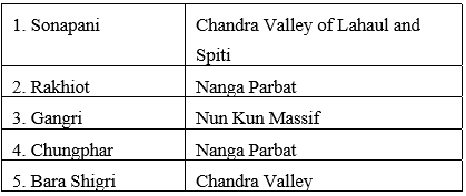
(ii) Dhaula Dhar Range
- It stretches from the banks of the Beas river in Kullu and then curves towards the town of Mandi, finally running north through Bara Bhangal to join the Pir Panjal range.
- It is cut across by the river Ravi.
- Mostly composed of granite but limestone and sandstone also exist in some parts.
- The highest point is Hanuman Tibba.
- The Lam Dal Lake and the Indrahar Pass are located here.
(iii) Mussoorie Range
- These are small hills running from the Shiwalik range in the south towards the Nag Tibba Range.
- It forms the water divide between Ganga and Sutlej rivers.
- The popular hill resort, Mussoorie is located in this range.
(c) THE GREAT HIMALAYAS
- This is also known as Inner Himalayas, Central Himalaya or Himadri.
- It is the northernmost and the innermost of all the Himalayan ranges.
- Average elevation: 6100m above sea level; Average width 25km.
Formation
It is formed of crystalline (granite and gneiss) and is overlain by metamorphosed sediments. The folds in the range are asymmetrical with a steep south slope and a gentle north slope giving it hogback topography. The mountain arc convex to the south terminates abruptly in the Nanga Parbat in the north-west and the Namcha Barwa in the north-east.
This mountain range boasts the tallest peaks in the world with the highest being Mount Everest (8850m). This range is formidable- it cannot be easily crossed even through the passes because they are generally higher than 4570m above sea level and snowbound for most of the year.
Important passes:
- Burzil pass and Zoji la in Jammu and Kashmir
- BaraLacha La and Shipkila in Himachal Pradesh
- Thaga La, the Niti pass and Lipu Lekh pass in Uttarakhand
- Nathu La and Jelep La in Sikkim
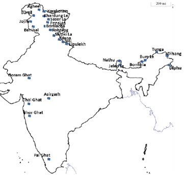
Important Passes of India
➢ Important Peaks of Great Himalayas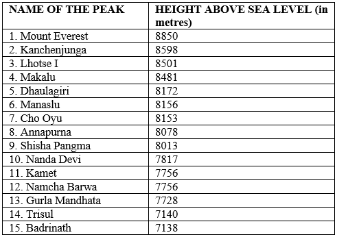
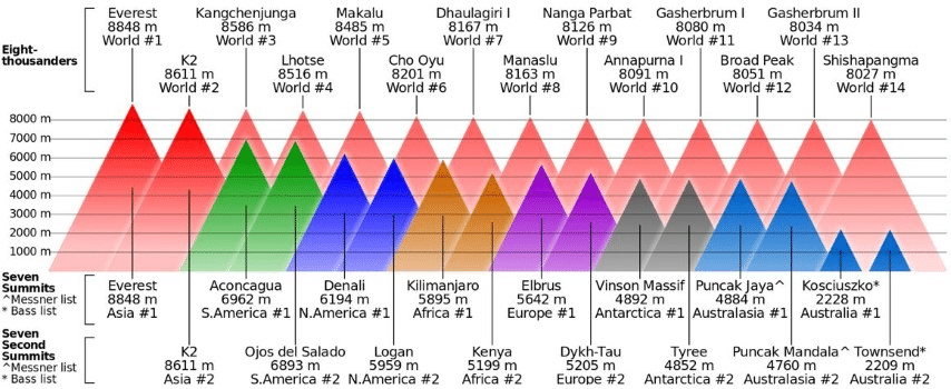
Some Important Himalayan Peaks
2. THE TRANS HIMALAYAS
- These are immediately north of the Greater Himalayas.
- This part of the Himalayan ranges is also called as Tibetan Himalaya as most of it lies in Tibet.
- Main Ranges: The Zaskar, the Ladakh, the Kailas and the Karakoram.
- Average Elevation: 3000 m above sea level.
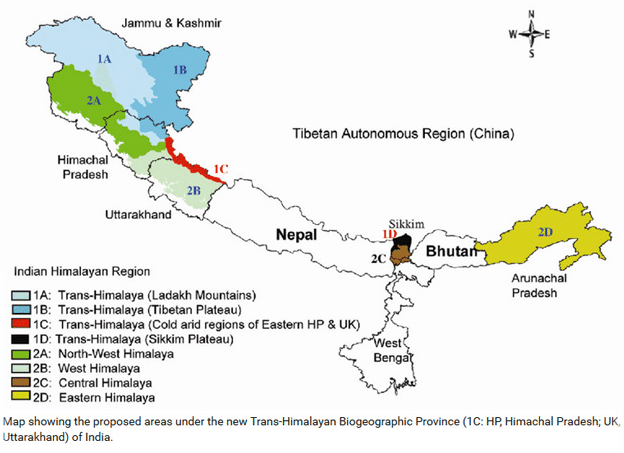
The Trans-Himalayas
➢ Main Ranges of Trans Himalaya
(i) Zaskar Range: It branch off from the Great Himalayan Range and runs almost parallel to it. The Nanga Parbat forms its culmination in the north-west.
(ii) Ladakh Range: This runs north of Zaskar Range and is parallel to it. It is about 300 km long and its average elevation is 5800 m above the sea level.
(iii) Kailas Range: It is an offshoot of the Ladakh Range. Its average elevation is above 55000-6000 m above sea level. The highest peak is Mt. Kailash (6714m). River Indus originates from the northern slopes of the Kailash Range.
(iv) Karakoram Range: The northernmost range of the Trans Himalayas is the Great Karakoram Range also known as Krishnagiri Range. It forms India’s frontier with Afghanistan and China and acts as the watershed between India and Turkistan. The average width of the range: 120-140 km. Average Elevation 5500m.
- Some peaks are more than 8000m above sea level. K2/ Godwin Austen (8611m) is the second highest peak in the world and the highest peak in India.
- Some important glaciers in the Karakoram Range:-
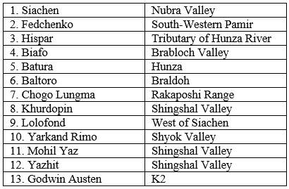
➢ The Ladakh Plateau lies to the north-east of the Karakoram Range. The average elevation: over 5000m above sea level and is the highest plateau of the Indian Union. It has been dissected into several plains and mountains.
Some of the important ones are:
- Soda Plains
- Aksai Chin
- Lingzi Tang
- Depsang Plains
- Chang Chenmo
1. Ladakh Range
2. Karakoram Range
3. Kailas Range
4. Zaskar Range
Choose the correct answer:
3. THE EASTERN HILLS/ THE PURVANCHAL
- After passing the Dihang gorge, the Himalayas take a sudden southward turn and form a series of comparatively low hills that runs in the shape of a crescent with its convex side pointing towards the west. These are called the Purvanchal.
- It extends from Arunachal Pradesh in the north to Mizoram in the south and forms the boundary with Myanmar. They differ from the Himalayas in terms of relief and morphology. To its north is the Patkai Bum which forms the International boundary between Arunachal Pradesh and Myanmar.
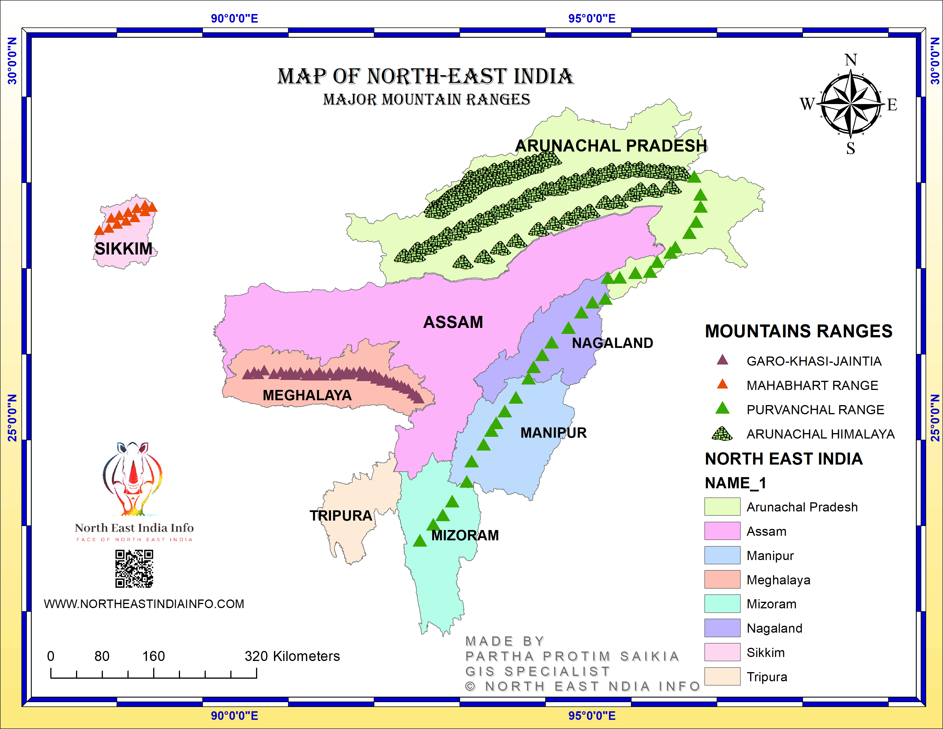 Purvanchal Hills
 - It is made up of strong sandstone.
- Further to the south, it merges into the Naga Hills where Saramati (3826 m) is the highest peak.
- Patkai Bum and the Naga Hills form the watershed between India and Myanmar.
- South of Naga hills are the Manipur Hills whose elevation is less than 2500 m which form the boundary between Manipur and Myanmar. Naga and Manipur hills are separated by the Barail Range.
- South of Manipur Hills are the Mizo Hills (earlier known as Lushai Hills)
- The highest point is the Blue Mountain (2157m) in the south.
- The Meghalaya Plateau consisting of the Garo, Khasi and Jaintia Hills (from West to East) are not part of the Purvanchal Hill system. These are an extension of the Peninsular Plateau.
FAQs on Division of The Himalayas - UPSC
| 1. What is the division of the Himalayas? |  |
| 2. What are the geographical features of the Eastern Himalayas? |  |
| 3. What are the main features of the Central Himalayas? |  |
| 4. What are the cultural aspects of the Western Himalayas? |  |
| 5. What are some popular tourist destinations in the Himalayas? |  |


