Geography: April 2024 Current Affairs | General Test Preparation for CUET UG - CUET Commerce PDF Download
India Developing Early Warning Systems in Partner Nations
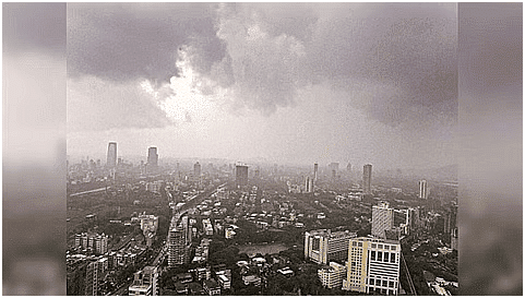
Context
India is actively working to support neighboring nations and small island countries in establishing early warning systems to mitigate the effects of extreme weather events. This effort is intended to minimize the loss of life and property, in line with the United Nations' 'Early Warnings for All' initiative.
How does India Plan to Help Partner Countries?
About:
- Due to the lack of capacity in many countries, especially those that are poor, least developed, or small island nations like Maldives and Seychelles, India is committed to playing a crucial role in assisting countries such as Nepal, Maldives, Sri Lanka, Bangladesh, and Mauritius in developing early warning systems.
Role of India in Developing Early Warning System (EWS):
- India is offering technical expertise and financial assistance to five partner countries through public-private partnerships for financial backing, with technical support from India and other contributing nations.
- India will assist in establishing meteorological observatories in partner countries.
- Partner nations will gain access to India's numerical models to enhance their forecasting capabilities.
- India will assist in creating decision support systems to facilitate timely responses to extreme weather events.
- The respective ministries of communication in partner nations will collaborate to establish data exchange and warning dissemination systems.
What are the Trends Related to the Extreme Weather Events?
- Global Trends: A report from the World Meteorological Organization (WMO) highlights a five-fold increase in natural disasters between 1970 and 2019, with water-related disasters emerging as the most prevalent globally.
- Impact on Asia: Asia has experienced significant impacts, with over 146,000 fatalities and more than 911 million people directly affected by disasters from 2013 to 2022. Economic damages in 2022 alone exceeded USD 36 billion, mainly due to flooding and storms.
- Human and Economic Toll: Between 1970 and 2021, nearly 12,000 weather, climate, or water-related disasters occurred, resulting in over two million deaths and economic losses surpassing USD 4.3 trillion.
- The Role of Climate Change: Climate change exacerbates the frequency and severity of disasters, making them more likely and challenging to manage effectively.
- Future Projections: By 2030, it is projected that the world could experience 560 medium- to large-scale disasters annually.
- India As a Key Player: India's efforts to strengthen early warning systems highlight the importance of international collaboration in addressing the escalating threat of natural disasters and climate change.
Demographic Transition of India
Context
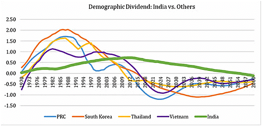
- India’s population growth is a significant concern, with UN projections estimating it to reach 1.7 billion by 2065, underscoring the ongoing transition of the demographic dividend.
- It redirects attention to a critical yet less emphasised factor: the declining fertility rates, forecasted to decrease to 1.29 by 2051, as per the Lancet Report.
- The government’s anticipated Total Fertility Rate (TFR) for 2021-2025 (1.94) and 2031-2035 (1.73) surpasses the estimates provided by The Lancet study and NFHS 5 data.
- This indicates the potential for India’s population to stabilise below 1.7 billion sooner than the projected year of 2065.
The Demographic Transition and Demographic Dividend
- A demographic shift denotes alterations in a population’s makeup over time, influenced by factors like birth and death rates, migration patterns, and shifts in social and economic conditions.
- A demographic dividend arises when a nation’s population transitions from a high dependency ratio (comprising mainly children and elderly) to a higher proportion of working-age adults.
- This structural change can fuel economic growth and development provided the country invests in human capital and fosters conditions for productive employment.
What Factors Triggered Demographic Transition in India?
- Rapid Economic Development: Economic growth, especially since the early 21st century, has been a key catalyst for demographic transition. Enhanced living standards, improved healthcare, and expanded education access have collectively driven down fertility rates.
- Reduction in Infant and Child Mortality Rates: Declines in infant and child mortality have lessened the necessity for larger families to provide old-age support. With improved healthcare and reduced child mortality, families feel more secure in having fewer children.
- Rise in Women’s Education and Work Participation Rates: Increased female education and workforce engagement have been instrumental. As women attain higher education and financial independence, they opt for smaller families and postpone childbirth, resulting in lower fertility rates.
- Improvement in Housing Conditions: Better housing and access to basic amenities enhance quality of life, influencing family planning decisions. Families often choose smaller sizes when living conditions improve.
The Challenges of Demographic Transition in India
- Dependency Ratio Shift: Initially, a decrease in Total Fertility Rate (TFR) leads to a decline in the dependency ratio and a larger working-age population. However, over time, it results in a larger proportion of elderly dependents, straining healthcare and social welfare resources, akin to situations observed in China, Japan, and European countries.
- Uneven Transition Across States: The decline in fertility rates varies across Indian states, with larger states like Uttar Pradesh, Bihar, and Jharkhand potentially taking longer to achieve replacement level fertility. This can worsen regional economic development and healthcare disparities.
- Labour Productivity and Economic Growth: While the demographic transition can boost labour productivity and economic growth, managing the ageing workforce and ensuring skill development for the younger population pose challenges.
What are the Opportunities of Demographic Transition in India?
- Enhanced Labour Productivity: The demographic transition can lead to a slowdown in population growth, potentially increasing the availability of capital resources and infrastructure per capita, thus boosting labour productivity.
- Reallocation of Resources: Decreasing fertility rates enable resources to be redirected towards education and skill development, enhancing human capital and workforce productivity.
- This shift may improve educational outcomes without additional state spending, as seen in states like Kerala where declining Total Fertility Rate (TFR) has reduced school enrollments.
- Increased Women Participation in Workforce: Lower fertility rates reduce the need for childcare, potentially leading to greater female workforce participation. Trends like higher female engagement in schemes such as the Mahatma Gandhi National Rural Employment Guarantee (MGNREGA) indicate a growing trend towards female labour force participation.
- Spatial Redistribution of Labour: Labour movement from regions with surplus to those with expanding industries can create spatial balance in the labour market. This trend may be bolstered by growing sectors in southern states, Gujarat, and Maharashtra attracting labour from northern states. Over time, this should improve working conditions, reduce wage discrimination for migrant workers, and address security concerns in receiving states through institutional safeguard
Way Forward
- As highlighted in the Asia 2050 report, India stands to become a prominent economic force in the 21st century by leveraging opportunities such as sectoral and spatial workforce redistribution, skill enhancement, and increased women’s participation in the labour force.
- Effectively harnessing India’s demographic dividend can substantially enhance global economic competitiveness.
- The shifting population dynamics underscore the importance of policy formulation, especially in healthcare, education, and skill advancement.
- Policies must be tailored to meet the unique requirements of women and other marginalised segments, promoting inclusive growth and development.
Time Zone for Moon
Context
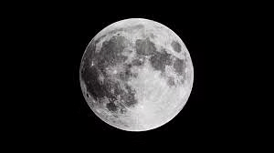
The European Space Agency is currently developing a universal timekeeping system specifically designed for the moon.
What is Timekeeping on the Moon?
About:
- The Moon, Earth's only natural satellite, experiences its own unique day and night cycle, lasting approximately 29.5 Earth days. Currently, time on the Moon is measured using Universal Time Coordination (UTC), the same system used on Earth.
- The European Space Agency is developing 'Coordinated Lunar Time' (LTC) as a standardized time system for the Moon.
Need of LTC:
- LTC will serve as a precise timekeeping reference for lunar spacecraft and satellites that require exceptional accuracy for their missions. It will facilitate synchronized communication between satellites, astronauts, bases, and Earth.
- Due to the Moon's longer day compared to Earth's, using UTC for daily activities on the Moon would be challenging. The International Space Station (ISS), orbiting Earth, will continue to use coordinated universal time (UTC).
- The Moon's weaker gravitational force causes time to move approximately 58.7 microseconds faster per day compared to Earth. To address this, researchers propose establishing a lunar time zone based on the Moon's day and night cycle, aiding lunar settlers in time management and activity coordination.
- A lunar time zone would facilitate research, experimentation, and data collection on the Moon, while preventing confusion and errors from using different timekeeping systems.
Challenges:
- Establishing a unified time standard for the Moon necessitates extensive global cooperation and consensus on the scientific aspects of timekeeping.
India’s Soil Erosion Crisis
Context
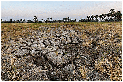
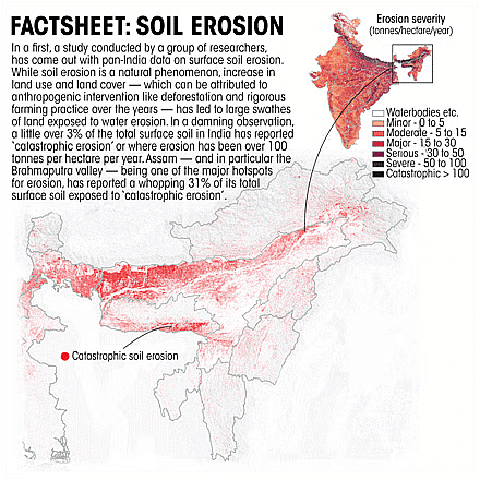
A recent study has highlighted the alarming extent of soil erosion in India, indicating substantial challenges and implications for agricultural productivity and environmental sustainability. The study utilized the Revised Universal Soil Loss Equation (RUSLE) to estimate soil erosion nationwide. This equation takes into account various factors including projected crop damage, rainfall patterns, soil erodibility, and land management practices.
What are the Key Highlights of the Study?
- 30% of India's landmass is experiencing "minor" soil erosion, 3% facing "catastrophic" topsoil loss.
- Brahmaputra Valley in Assam is identified as the country's biggest hotspot for soil erosion.
- Odisha highlighted as another hotspot for "catastrophic" erosion due to anthropogenic interventions.
- Catastrophic erosion is defined as over 100 tonnes of soil lost per hectare annually.
What is the Status of Soil Erosion in India?
About Soil Erosion
Soil erosion refers to the process of soil being moved or displaced from one location to another. The rate of erosion can vary based on factors such as climate, topography, vegetation cover, and human activities.
Factors Contributing to Soil Erosion
- Natural Causes:
- Wind: Strong winds can lift and carry away loose soil particles, particularly in dry regions with sparse vegetation.
- Water: Heavy rainfall or fast-flowing water can detach and transport soil particles, especially on sloped terrain or areas with limited vegetation cover.
- Glaciers and Ice: Glacier movement can scrape and transport large amounts of soil, and freezing/thawing cycles can break soil particles and increase erosion susceptibility.
- Human-Induced Factors:
- Deforestation: Removing trees and vegetation for land clearing eliminates the natural root network that holds soil in place, increasing its vulnerability to erosion.
- Poor Agricultural Practices: Conventional farming methods like excessive tilling can degrade soil structure and increase erosion risk. Leaving fields bare during fallow periods or improper crop rotation also contribute.
- Overgrazing: Excessive livestock grazing damages vegetation cover, exposing soil to erosion.
- Construction Activities: Land clearing and excavation during construction disturb soil, making it more susceptible to erosion without proper precautions.
- Degraded Soil in India:
- According to the National Bureau of Soil Survey and Land Use Planning, approximately 30% of India's soil is degraded. Of this, around 29% is lost to the sea, 61% is transferred from one location to another, and 10% is deposited in reservoirs.
What are the Challenges Related to Soil Health in India?
- Low Organic Carbon Content: Indian soils typically have very low organic carbon content, which is crucial for fertility and water retention.
- The soil organic carbon (SOC) content in Indian soils has declined from 1% to 0.3% in the past 70 years.
- Nutrient Deficiencies: A significant portion of Indian soils suffer from deficiencies in major nutrients like nitrogen, phosphorus, and potassium.
- Over-reliance on chemical fertilisers exacerbate this problem.
- Water Management Issues: Both water scarcity and improper irrigation practices harm soil health. Insufficient water can lead to salinisation, while over-irrigation can cause waterlogging, both impacting soil fertility and structure.
- Around 70% of irrigation water in India is wasted due to the poor management of the farmer.
- Socioeconomic Factors: Land fragmentation due to population pressures and economic constraints can make it difficult for farmers to adopt sustainable practices that improve soil health.
- The average landholding size in India is 1-1.21 hectare.
What Measures can be Adopted to Prevent Soil Erosion and Improve Soil Health?
- Biochar and Biofertilizers
- Combining the application of biochar with biofertilizers represents a potent strategy. Biochar retains nutrients and water, while biofertilizers enhance nutrient availability and promote soil health. This approach can reduce dependence on chemical fertilizers and enhance soil fertility.
- Biochar is a charcoal-like substance produced through pyrolysis (heating in the absence of oxygen) of organic materials such as crop residues, manure, or weeds. Biofertilizers consist of live microorganisms that enhance soil fertility and plant growth.
- Drone Technology for Precision Agriculture
- The Namo Drone Didi Scheme can be integrated with soil conservation efforts. Drones equipped with multispectral sensors can map soil health parameters like nutrient levels, organic matter content, and moisture levels over large agricultural fields.
- This data enables precise application of fertilizers and soil amendments, minimizing wastage and optimizing effectiveness. Drones can also be used for targeted seeding and weed control, minimizing soil disturbance.
- Regenerative Agriculture Practices
- Integrating no-till farming and incorporating compost allows for a tailored approach to different regions. Exploring innovative cover cropping techniques such as multi-species cover cropping can provide additional benefits like weed suppression and improved soil structure.
Taiwan Earthquake and Pacific Ring of Fire

Context
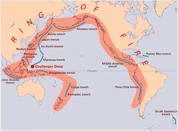
Taiwan experienced a 7.2 magnitude earthquake, the most powerful in the past 25 years. The quake's epicenter was situated just 18 kilometers south-southwest of Hualien County in eastern Taiwan. Taiwan is susceptible to earthquakes due to its location along the Pacific "Ring of Fire," where about 90% of the world's earthquakes occur.
What is Ring of Fire?
- About
- The Ring of Fire is essentially a string of hundreds of volcanoes and earthquake-sites which runs along the Pacific Ocean.
- It is a semicircle or horse shoe in shape and stretches nearly 40,250 kilometres.
- Numerous tectonic plates involved
- The Ring of Fire traces the meeting points of numerous tectonic plates.
- This includes the Eurasian, North American, Juan de Fuca, Cocos, Caribbean, Nazca, Antarctic, Indian, Australian, Philippine, and other smaller plates.
- All these encircle the large Pacific Plate.
- Runs through various countries
- It runs through 15 more countries including the USA, Indonesia, Mexico, Japan, Canada, Guatemala, Russia, Chile, Peru, and the Philippines.
Why is the Ring of Fire vulnerable to earthquakes?
- The Ring of Fire witnesses so many earthquakes due to constant sliding past, colliding into, or moving above or below each other of the tectonic plates.
- As the edges of these plates are quite rough, they get stuck with one another while the rest of the plate keeps moving.
- An earthquake occurs when the plate has moved far enough and the edges unstick on one of the faults.
- Taiwan experiences earthquakes due to the interactions of two tectonic plates — the Philippine Sea Plate and the Eurasian Plate.
Why are there so many volcanoes in the Ring of Fire?
- The abundance of volcanoes in the Ring of Fire is primarily due to a geological process called subduction. This occurs when two tectonic plates collide, with the heavier plate being forced beneath the other, creating a deep trench. Specifically, when an oceanic plate (like the Pacific Plate) is subducted into a hotter mantle plate, it heats up, leading to the mixing of volatile elements and the production of magma.
- This magma then rises through the overlying plate and erupts at the surface, resulting in the formation of volcanoes. The Ring of Fire hosts numerous volcanoes because most of the world's subduction zones are located in this region.
Why is Taiwan so exposed to earthquakes?
- Taiwan is highly vulnerable to earthquakes due to its location along the Pacific Ring of Fire, which is characterized by frequent seismic activity. The island is situated at the convergence of two tectonic plates—the Philippine Sea Plate and the Eurasian Plate—resulting in significant tectonic stress and frequent seismic events.
- Additionally, Taiwan's mountainous landscape can amplify ground shaking during earthquakes, leading to landslides and other secondary hazards.
Preparedness of Taiwan
- During a recent earthquake measuring 7.2 according to Taiwan's earthquake monitoring agency (or 7.4 according to the U.S. Geological Survey), several buildings in Hualien were damaged, although losses in the capital Taipei were minimal despite strong shaking. Taiwan has implemented rigorous building codes, maintains a world-class seismological network, and conducts widespread public education campaigns on earthquake safety.
- The government continuously updates quake resistance requirements for buildings and offers subsidies to residents for checking their buildings' seismic resilience. Furthermore, Taiwan conducts regular earthquake drills in schools and workplaces, and public media and mobile alerts regularly disseminate earthquake notifications and safety information.
Total Solar Eclipse

Context
On April 8, 2024, a total solar eclipse will occur, providing a rare celestial spectacle as the Sun temporarily disappears from view in the sky.
About Total Solar Eclipse
- A total solar eclipse is a condition when the Moon passes between the Sun and the Earth and completely blocks the Sun's disk, casting a huge shadow on the surface.
- People viewing the eclipse from locations where the Moon’s shadow completely covers the Sun–known as the path of totality–will experience a total solar eclipse.
- As per NASA, during this timeframe, the sky will darken, resembling the onset of dawn or dusk.
- Weather permitting, individuals along the path of totality will have the opportunity to observe the Sun’s corona, its outer atmosphere typically obscured by the Sun’s bright face.
- The Sun’s corona, the outermost layer of its atmosphere extending millions of kilometers into space, is exclusively visible during a solar eclipse. Appearing as a faint, pearly-white halo encircling the darkened disk of the Sun, it becomes observable only during this celestial event.
- This solar eclipse will be characterised by a phenomenon known as totality - a condition when viewers may be able to see the chromosphere (a region of the solar atmosphere, appearing as the thin circle of pink around the Moon) along with the corona.
- The totality will offer a rare view where you can momentarily see the stars during the time as the surroundings go completely dark.
- It will also be marked by a dip in air temperatures.
Magnetic Fossils in Bay of Bengal
Context
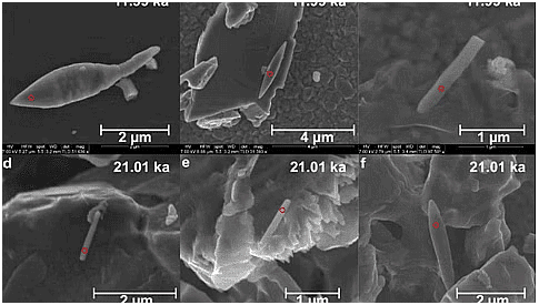
Recently, Researchers at the CSIR-National Institute of Oceanography discovered 50,000-year-old magnetic fossils in the Bay of Bengal. It is one of the youngest and most enormous magnetic fossils.
Magnetic Fossils in Bay of Bengal: Key Findings of the Study
- Fluctuations in Monsoon: Analysis of sediment samples revealed changes in monsoon strength over the last Glacial Maximum-Holocene epoch, which influenced weathering and sedimentation.
- The Holocene represents the most recent interglacial interval of the Quaternary Period.
- Appropriate environment for Magnetic Fossil Growth: According to the study, warming events are not required to produce large magneto fossils; instead, a proper balance of iron, organic carbon, and suboxic environments is critical.
- Role of Rivers in Formation of Magnetic Fossils: The rivers Godavari, Mahanadi, Ganga-Brahmaputra, Cauvery, and Penner, which flow into the Bay of Bengal, all played essential roles in the development of magnetofossils.
- Discharge of Freshwater: The freshwater discharge from these rivers, combined with other oceanographic processes such as eddy formation, resulted in oxygen levels in these waters that are not often observed in other low-oxygen zones.
- Finding of Single-Celled Organisms: Researchers discovered many benthic and planktonic foraminifera, single-celled organisms with shells that live near the seabed and float freely in water.
About Magento Fossils
- About: These are the fossilized remains of magnetic particles produced by magnetotactic bacteria, commonly known as magneto bacteria, and discovered and preserved in geological records.
- Definition: Magneto fossils are biological materials that include magnetic minerals, primarily magnetite (Fe3O4) and greigite (Fe3S4).
- Magnetotactic bacteria are primarily prokaryotic organisms that align with the earth’s magnetic field. These distinctive creatures were originally described in 1963.
- Following the Magnetic Field: These organisms were thought to follow the magnetic field to areas with high oxygen concentrations.
- Characteristics of Magnetotactic Bacteria: These bacteria contained “novel structured particles, rich in iron” in microscopic sacs that functioned as a compass.
- These magnetotactic bacteria produce microscopic crystals of magnetite or greigite, both iron-rich minerals. The crystals assist them in navigating the fluctuating oxygen levels of the aquatic body in which they live.
Types of Magneto Fossils
- Bacterial Magnetite: Certain bacteria may produce magnetite within their cells, forming chains of magnetosomes that function as tiny compass needles.
- Magnetic Crystals in Organisms: Some organisms, including mollusks, fish, and birds, can biomineralize magnetite or greigite within their tissues.
- Significance of Magneto Fossils: Paleoenvironmental Reconstruction: The presence of magneto fossils in sedimentary rocks can reveal information about past habitats, such as oxygen levels, temperature, and even the presence of certain animals.
- Paleomagnetism: Magneto fossils help to reconstruct the Earth’s past magnetic field. Scientists can learn about the past orientation of the Earth’s magnetic field by examining the orientation and intensity of magnetic minerals in fossils.
- Biological Behaviour: Investigating magneto fossils can provide information about the behaviour and ecology of ancient creatures.
- For example, the presence of magnetite in some creatures may imply that they can navigate using the Earth’s magnetic field.
Tropical Cyclones Need New Category
Context
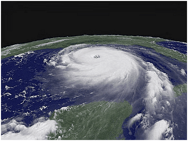
A new study published in the Proceedings of the National Academy of Sciences suggests that hurricane wind speeds can exceed 309 km/hour, leading researchers to propose the addition of a Category 6 to the current wind scale.
What are the Key Highlights of the Study?
Reevaluation of the Saffir-Simpson (SS) Scale:
- Concerns have arisen regarding the adequacy of the Saffir-Simpson (SS) Hurricane Wind Scale, which has been in use for over 50 years to convey hurricane risk based solely on wind speed. The SS scale consists of five categories, ranging from category 1 to category 5, with category 5 winds exceeding 252 km/hour.
- The cumulative impact of wind, storm surge, and rainfall during a category 5 event would completely destroy any structure. The indefinite nature of Category 5 may no longer effectively communicate the escalating risk of hurricane damage in a warming climate.

- Introduction of Hypothetical Category 6:
- Due to Global Warming, there is now a need to define a category 6 cyclone.
- The warming can be observed not only at the sea surface, but also in the depths of the ocean, which increases the heat content of the ocean and thus favours the intensification of tropical cyclones.
- To address the limitations of the existing scale the introduction of a hypothetical Category 6 to the Saffir-Simpson Wind Scale is proposed with the wind speed above 309 km/hour.
- Impact of Global Warming on Hurricane Intensification:
- Increased greenhouse gas emissions have caused the Earth to warm by about 1.10 degrees Celsius since pre-industrial times and caused more intense tropical cyclones in the oceans.
- For every degree of warming, the strongest cyclones are getting 12% stronger, making them 40% more destructive.
- As the oceans warm, cyclones also strengthen faster and spend more lifetime over the oceans.
- In 2023, tropical cyclone Freddy spent 37 days over the oceans, making it the longest-lived cyclones ever recorded.
- Implications for Risk Messaging:
- The findings underscore the importance of revising risk messaging to better inform the public about the increased risk of major hurricanes due to global warming.
- SS Scale does not address issues related to inland flooding and storm surge, which are also critical components of hurricane risk.
- Therefore, changes in messaging beyond wind-based scales are necessary to adequately communicate the full spectrum of hurricane hazards.
Africa’s Afar Triangle: Birthplace of a Potential New Ocean
Context
Recent geological findings suggest that Africa's Afar Triangle could be the birthplace of a new ocean in 5 to 10 million years. This phenomenon, unfolding amidst the rich and diverse landscapes of the African continent, offers a rare glimpse into the dynamic processes that shape Earth's geography.
What is Africa’s Afar Triangle?
- About: The Afar Triangle, nestled in the Horn of Africa, is a geological depression where three tectonic plates, the Nubian, Somali, and Arabian plates converge.
- It is part of the East African Rift system, which extends from the Afar region down through eastern Africa.
- Beyond its geological significance, the Afar Triangle holds a rich paleontological history, disclosing fossil specimens of some of the earliest hominins.
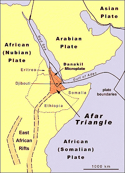
- Tectonic Movement and Rift Expansion: The Afar region has been experiencing gradual tectonic movements for millions of years.
- The rift's expansion was notably highlighted in 2005 when a significant rift opened up in the Ethiopian desert, indicating the ongoing separation of the African continent at a tectonic level.
- Factors Responsible for Rift’s Expansion:
- One of the key factors driving the rifting process is believed to be a massive plume of superheated rocks rising from the mantle beneath East Africa.
- This plume could be exerting pressure on the overlying crust, causing it to stretch and fracture.
- Also, the magmatism in the region, particularly at the Erta Ale volcano, offers clues to the tectonic transition, with characteristics that mimic those of a mid-ocean ridge.
- Magmatism is the formation and motion of magma below Earth's surface. It contributes to various phenomena on Earth, such as filling tectonic cracks, forming mountains, and aiding in the release of heat from the Earth's core.
- Formation of Ocean: This ongoing rift expansion in this region could potentially lead to the formation of a new ocean, tentatively named the "Alvor-Teide Atlantic Rift".
- This new body of water would be the result of the Red Sea and the Gulf of Aden flooding over the Afar region and into the East African Rift Valley.
Honeycomb Clouds and Clean Air of Southern Ocean the Earth
Context
Scientists found that the Southern Ocean's clean air results from reduced winter sulphate production, along with the cleansing effect of clouds and rain, particularly from open honeycomb clouds, enhancing climate modelling and improving air quality.
- The Southern Ocean, an expansive and isolated body of water surrounding Antarctica, has been acknowledged for its exceptionally pure air. Yet, the precise causes of this notable phenomenon had remained undisclosed until recent scientific progress unveiled the interaction involving clouds, rainfall, and a distinctive cloud structure called the honeycomb cloud.
Beyond the Absence of Human Activity
- While the limited human presence in this region naturally translates to less industrial pollution from burning fossil fuels or using chemicals, it's not the sole contributor.
- Natural sources like sea spray, tiny airborne droplets produced by crashing waves, and wind-whipped dust particles add their own share of fine particles, known as aerosols, to the atmosphere. Regardless of their origin, these aerosols are detrimental to air quality. The goal is to minimise their presence for truly clean air.
Rainfall's Role in Purification
- Research has brought to light the crucial role clouds and rain play in purifying the Southern Ocean's atmosphere.
- Unlike other parts of the world, the Southern Ocean experiences occasional, short-lived rain showers with exceptional intensity.
Honeycomb Clouds
- With the new generation of satellites offering high-resolution images, researchers were able to identify distinct honeycomb patterns within the cloud formations across the vast expanse of the Southern Ocean. These honeycomb clouds hold immense significance for regulating Earth's climate.
- When a honeycomb cell is filled with clouds, creating a "closed" state, it appears whiter and brighter. This characteristic allows it to reflect more sunlight back into space, contributing to a cooler Earth.
- Empty, or "open," honeycomb cells might seem less cloudy in satellite imagery, but here's the surprising twist: they are linked to cleaner air. These open cells are packed with more moisture, leading to significantly heavier rain showers compared to their closed counterparts. These intense downpours effectively "wash out" the aerosol particles from the air, acting as a natural air scrubber.
- Another interesting observation is that open honeycomb clouds are more prevalent during winter months. This neatly coincides with the period when the Southern Ocean boasts its cleanest air. Scientists believe large-scale weather systems influence the formation of these open and closed honeycomb patterns.

Southern Ocean
- The Southern Ocean, also known as the Antarctic Ocean, is a vast body of water encircling Antarctica. It holds the distinction of being the world's second-smallest ocean.
- It was formed around 34 million years ago when Antarctica and South America drifted apart, creating the Drake Passage.
- Occupying the southernmost waters of the Earth, the Southern Ocean generally stretches south of 60 degrees latitude.
- This ocean plays a vital role in regulating Earth's climate through a process called overturning circulation. Similar to the Atlantic Meridional Overturning Circulation (AMOC), this circulation helps move heat around the globe.
|
164 videos|800 docs|1160 tests
|


