Long Questions: Maps | NCERT Summary: UPSC PDF Download
Q1: What are symbols? Why do we need them?
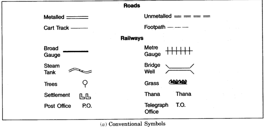
Ans: Symbols: It is impossible to draw actual shape and size of different features like buildings, roads, trees, railway lines or a well on a map, so we use various symbols to show these features.
- Symbols give much information in a limited space.
- With the help of these symbols, we can draw maps and read them easily.
- Without knowing the language of a certain place, we can collect information from maps with the help of these symbols.
- Maps have a universal language – a language that can be read by all. An international agreement facilitates the use of these symbols.
- These symbols are called Conventional Symbols.
- Some of the conventional symbols are shown in the figure given below.
- Various colours in maps are also used for the same purpose.


Q2: How is distance measured? Define a scale.
Ans: Maps reduce the entire world or its part to fit on a sheet of paper. But this reduction is done very carefully so that distances between the places are kept true:
- Reduction of map is only possible when small distances on paper represents a large distance on the ground.
- To reduce a map, a scale is chosen.
Scale is the ratio between the actual distance on the ground and the distance shown on the map.
- The distance between school and home of student is 10 km. If he shows this 10 km distance by 2 cm on map, it means, 1 cm on the map will show 5 km on ground. Thus the scale will be 1 cm. = 5 km. In this way scale is very important in a map. If the scale is known it will be easy to calculate distance between any two places.
- Scales are used for measuring distance. For example to find out the distance between the post office and the clock tower one can measure the distance between these points on the map. (Then the same distance on the scale. Types of Maps on the Basic of Scale.)
Q3: What kind of maps provide detailed information?
Ans: The maps could be on a small scale or on a vast scale. Large scale maps are used to get detailed information. Large distances are represented on paper by maps by decreasing them. The scale is the ratio between the real distance and the distance on the map. A modest scale is used to represent countries. Small scale maps are the name for this type of map. The size is greater to represent smaller places such as towns and villages. This type of map is referred to as a large scale map since it contains a lot of information.
Q4: What is the difference between a map and a plan?
Ans: A map is a scaled representation of a portion of the world's surface or the entire earth surface on a flat surface. The goal is to work with a tiny region on a vast scale. Maps are used to depict vast areas such as continents, countries, states, and cities, as well as smaller areas such as towns and villages. Plans are used to provide information such as the length and width of a room, among other things. This type of information is not included in the map.
Q5: How symbols are useful in reading a map?
Ans: It is impossible to draw all of the things on the maps to their exact shape and size, such as buildings, bridges, roads, trains, and so on. To demonstrate these characteristics, standard letters, colours, tints, drawings, and lines are employed instead. These symbols take up very little space, but they transmit a lot of information. As a result, symbols on maps are easier to use. It also neatens up the map and makes it easier to read.
Q6: Write down the three components of the map.
Ans: A map is a drawing on a flat surface that is drawn to scale. A map's three components are distance, direction, and symbol. Maps are drawn at smaller scales since that is the only way they will fit on the paper.The north direction is indicated on maps with the letter ‘N.' Because everything on a map can't be drawn to exact size and shape, symbols are employed to represent it.
Q7: How maps are more useful than globes?
Ans: The globe is important when we wish to study the entire earth as a whole. When only a small portion of the earth is being investigated, however, they do not yield much information. Maps can depict a portion of the earth or the full globe. They can aid in the visualisation of political divisions such as countries, states, and cities. Mountains, oceans, seas, rivers, and other physical features can also be displayed. Other data, such as rainfall and forests, can be displayed on maps.
|
666 docs
|

|
Explore Courses for UPSC exam
|

|


