NCERT Summary: India Location - 1 | Geography for UPSC CSE PDF Download
| Table of contents |
|
| Introduction |
|
| Structure |
|
| Physiography |
|
| Longitudinal Division |
|
| Glossary |
|

Introduction
The mainland of India extends from Kashmir in the north to Kanyakumari in the south and Arunachal Pradesh in the east to Gujarat in the west. India’s territorial limit further extends towards the sea up to 12 nautical miles (about 21.9 km) from the coast.
Statute mile= 63,360 inches
Nautical mile= 72,960 inches
1 Statute mile= about 1.6 km (1.584 km)
1 Nautical mile= about 1.8 km (1.852 km)
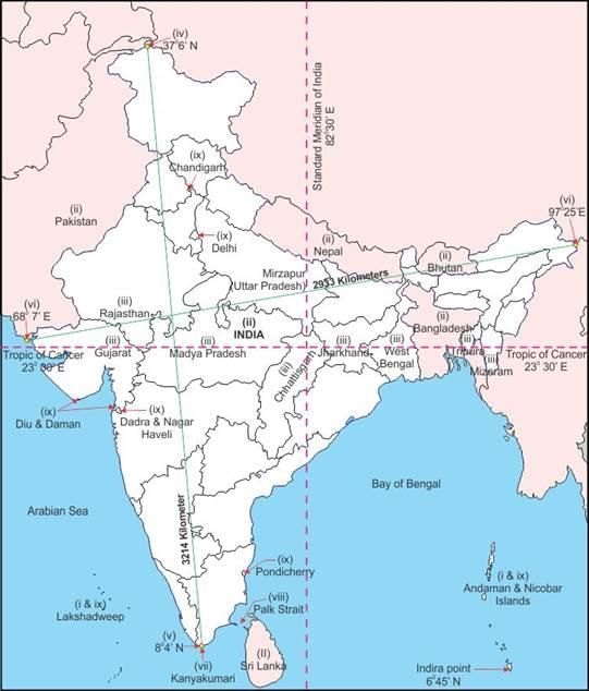
- Our southern boundary extends up to 6º45 N latitude in the Bay of Bengal. If you work out the latitudinal and longitudinal extent of India, they are roughly about 30 degrees, whereas the actual distance measured from north to south extremity is 3,214 km, and that from east to west is only 2,933 km.
What is the reason for this difference?
This difference is based on the fact that the distance between two longitudes decreases towards the poles whereas the distance between two latitudes remains the same everywhere.
- From the values of latitude, it is understood that the southern part of the country lies within the tropics and the northern part lies in the sub-tropical zone or the warm temperate zone. This location is responsible for large variations in landforms, climate, soil types, and natural vegetation in the country.
- There is a general understanding among the countries of the world to select the standard meridian in multiples of 7º30 of longitude. That is why 82º30 E has been selected as the ‘standard meridian’ of India. Indian Standard Time is ahead of Greenwich Mean Time by 5 hours and 30 minutes. There are some countries where there is more than one standard meridian due to their vast east-to-west extent.
For example, the USA has seven time zones. - Now, let us observe the extent and its implications on the Indian people. From the values of longitude, it is quite discernible that there is a variation of nearly 30 degrees, which causes a time difference of nearly two hours between the easternmost and the westernmost parts of our country.
What is the use of the standard meridian?
While the sun rises in the northeastern states about two hours earlier as compared to Jaisalmer, the watches in Dibrugarh, Imphal in the east and Jaisalmer, Bhopal or Chennai in the other parts of India show the same time.
Why does this happen? Name a few places in India through which the standard meridian passes?
- India with its area of 3.28 million sq. km accounts for 2.4 percent of the world’s land surface area and stands as the seventh-largest country in the world.
Structure
Current estimation shows that the earth is approximately 4600 million years old. Based on the variations in its geological structure and formations.
Indian can be divided into three geological divisions. These geological regions broadly follow the physical features:
- The Peninsular Block
- The Himalayas and other Peninsular Mountains
- Indo-Ganga-Brahmaputra Plain
➤ The Peninsular Block
- The northern boundary of the Peninsular Block may be taken as irregular the running from Kachchh along the western flank of the Aravali Range near Delhi and then roughly parallel to the Yamuna and the Ganga as far as the Rajmahal Hills and the Ganga delta.
- Apart from these, the Karbi Anglong and the Meghalaya Plateau in the northeast and Rajasthan in the west are also extensions of this block. The northeastern parts are separated by the Media fault in West Bengal from the Chotanagpur plateau. In Rajasthan, the desert and other desert-like features overlay this block.
- The Peninsula is formed essentially by a great complex of very ancient gneisses and granites, which constitutes a major part of it. Since the Cambrian period, the Peninsula has been standing like a rigid block with the exception of some of its western coasts which is submerged beneath the sea and some other parts changed due to tectonic activity without affecting the original basement. As a part of the Indo-Australian Plate, it has been subjected to various vertical movements and block faulting.
- The rift valleys of the Narmada, the Tapi and the Mahanadi, and the Satpura block mountains are some examples of it. The Peninsula mostly consists of relict and residual mountains like the Aravali hills, the Nallamala hills, the Javadi hills, the Veliconds hills, the Palkonda range, and the Mahendragiri hills, etc. The river valleys here are shallow with low gradients.
- Most of the east-flowing rivers form deltas before entering into the Bay of Bengal. The deltas formed by the Mahanadi, the Krishna, the Kaveri, and the Godavari are important examples.
➤ The Himalayas and other Peninsular Mountains
- The Himalayas along with other peninsular mountains are young, weak, and flexible in their geological structure unlike the rigid and stable peninsular Block, Consequently, they are still subjected to the interplay of exogenic and endogenic forces, resulting in the development of faults, folds, and thrust plains.
- These mountains are tectonic in origin, dissected by fast-flowing rivers which are in their youthful stage. Various landforms like gorges, V-shaped valleys, rapids, waterfalls, etc. are indicative of this stage.
➤ Indo-Ganga-Brahmaputra Plain
- The third geological division of India comprises the plains form by the river Indus, the Ganga, and the Brahmaputra. Originally, it was a geo-synclinal depression that attained its maximum development during the third phase of the Himalayan during the third phase of Himalayan mountain formation approximately about 64 million years ago.
- Since then, it has been gradually filled by the sediments brought by the Himalayan and Peninsular rivers. The average depth of alluvial deposits in these plains ranges from 1,000-2,000 m.
Physiography
‘Physiography’ of an area is the outcome of structure, process, and stage of development.
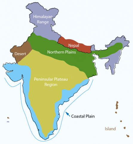
Based on these macro variations, India can be divided into the following physiographic divisions:
- Northern and Northeastern Mountains
- Northern Plain
- Peninsular Plateau
- The Indian Desert
- Coastal Plains
- The Islands
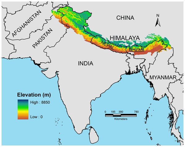
North and North Eastern Himalaya
- The formation of Physical features of the north and north-eastern Himalay is a result of “Plate tectonics” According to Plate Tectonic theory earth is divided into several plateaux.
- The formation of Himalayas & the north eastern mountain is due to the convergence of two plates Eurasia (North of Himalaya) and Gondwana (Indian subcontinent Australia, South Africa, South America). Both the plates came close to each other and Tethys sediment called geosyncline was pressed from two sides gave birth to the current Himalaya mountains.
- The Himalayan uplift out of the Tethys sea and subsidence of the northern flank of the peninsular plateau resulted in the formation of a large basin. In due course of time, this depression gradually got filled with deposition of sediments by the rivers flowing from the mountains in the north and the peninsular plateau in the south. Flatland of extensive alluvial deposits led to the formation of the northern plains of India.
- The land of India displays great physical variation. Geologically, the Peninsular Plateau constitutes one of the ancient landmasses on the earth’s surface. It was supposed to be one of the most stable land blocks. The Himalayan and the Northern Plains are the most recent landforms. From the viewpoint of geology, the Himalayan Mountains form an unstable zone. The whole mountain system of Himalaya represents a very youthful topography with high peaks, deep valleys, and fast-flowing rivers. The northern plains are formed of alluvial deposits. The peninsular plateau is composed of igneous and metamorphic rocks with gently rising hills and wide valleys.
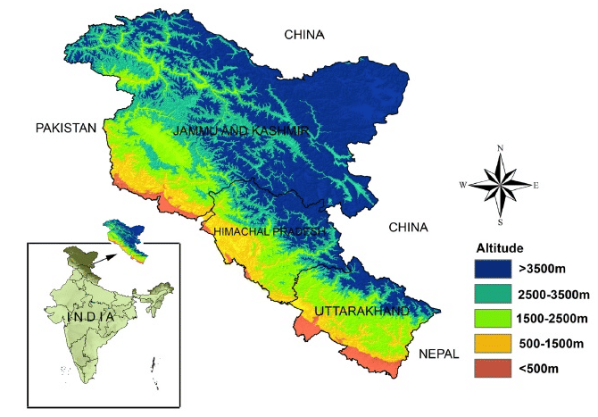
- The Himalayas, geologically young and structurally fold mountains stretch over the northern borders of India. These mountain ranges run in a west-east direction from the Indus to the Brahmaputra. The Himalayas represent the loftiest and one of the most rugged mountain barriers of the world. They form an arc, which covers a distance of about 2,400 Km.
 The Himalaya
 - Their width varies from 400 Km in Kashmir to 150 Km in Arunachal Pradesh. The altitudinal variations are greater in the eastern half than those in the western half.
- The Himalayas consists of three parallel ranges in their longitudinal extent. A number of valleys lie between these ranges. The northernmost range is known as the Great or Inner Himalayas or the ‘Himadri’. It is the most continuous range consisting of the loftiest peaks with an average height of 6,000 meters. It contains all the prominent Himalayan peaks. The folds of the Great Himalayas are asymmetrical in nature. The core of this part of the Himalayas is composed of granite. It is perennially snowing bound, and a number of glaciers descend from this range.
- The range lying to the south of the Himadri forms the most rugged mountain system and is known as Himachal or lesser Himalaya. The ranges are mainly composed of highly compressed and altered rocks. The altitude varies between 3,700 and 4,500 meters and the average width is 50 Km. While the Pir Panjal range forms the longest and the most important range, the Dhaula Dhar and the Mahabharat ranges are also prominent ones. This range consists of the famous valley of Kashmir, the Kangra, and the Kullu Valley in Himachal Pradesh. This region is well known for its hill stations.
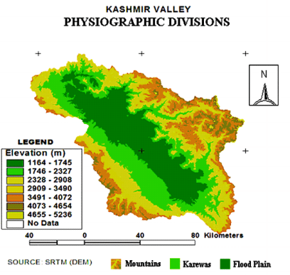
- Karewas are the thick deposits of glacial clay and other materials embedded with moraines. The outermost range of the Himalayas is called the Shiwaliks. They extend over a width of 10.50 Km and have an altitude varying between 900 and 1100 meters. These ranges are composed of unconsolidated sediment brought down by rivers from the main Himalayan ranges located farther north. These valleys are covered with thick gravel and alluvium. The longitudinal valley lying between the lesser Himalayas and the Shiwaliks is known as Duns. Dehra Dun, Kotli Dun, and Patli Dun are some of the well-known Duns.
- An Interesting Fact in Kashmir Valley, the meanders in Jhelum river are caused by the local base level provided by the erstwhile larger lake of which the present Dal lake is a small part.
- There are large-scale regional variations within the Himalayas.
On the basis of relief, alignment of ranges, and other geomorphological features the Himalayas can be divided into the following sub-divisions:
Longitudinal Division
- Kashmir or Northwestern Himalayas
- Himachal and Uttaranchal Himalayas
- Darjeeling and Sikkim Himalayas
- Arunachal Himalaya
- Eastern Hills and Mountains
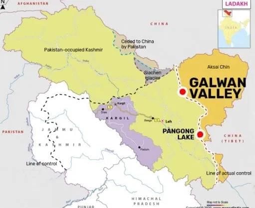
- It comprises a series of ranges such as the Karakoram, Ladakh, Zaskar and Pir Panjal. The northeastern part of the Kashmir Himalayas is a cold desert, which lies between the Greater Himalayas and the Karakoram ranges. Between the Great Himalayas and the Pir Panjal range, lies the world-famous Valley of Kashmir and the famous Dal Lake.
- Important glaciers of South Asia such as the Baltoro and Siachen are also found in this region. The Kashmir Himalayas are also famous for Karewa formations, which are useful for the cultivation of Zafran, a local variety of saffron. Some of the important passes of the region are Zoji La on the Great Himalayas. Banihal on the Panjal, Photo La on the Zaskar and Khardung La on the Ladakh range.
- Some of the important fresh lakes such as Dal and Wular and saltwater lakes such as Pangong Tso and Moriri are also in this region. This region is drained by the river Indus and its tributaries such as the Jhelum and the Chenab.
 Pangong Tso
 - Kashmir and the northwestern Himalayas are well-known for their scenic beauty and picturesque landscape. The landscape of the Himalayas is a major source of attraction for adventure tourists. Some famous places of pilgrimage such as Vaishno Devi, Amarnath Cave, Charar -e-Shariff, etc. are also located here and a large number of pilgrims visit these places every year.
- Srinagar, the capital city of the Jammu and Kashmir is located on the banks of the Jhelum river. Dal Lake in Srinagar presents an interesting physical feature. Jhelum in the valley of Kashmir is still in its youth stage and yet forms meander- a typical feature associated with the mature stage in the evolution of fluvial landforms.
- The southernmost part of this region consists of longitudinal valleys known as ‘duns’. Jammu dun and Pathankot dun are important examples.
➤ The Himachal and Uttaranchal Himalayas
- This part lies approximately between the Ravi in the west and the Kali (a tributary of Ghaghara) in the east. It is drained by two major river systems of India, i.e. the Indus and the Ganga. Tributaries of the Indus include the river Ravi, the Beas, and the Satluj, and the tributaries of Ganga flowing through this region include the Yamuna and the Ghaghara.
- The northernmost part of the Himachal Himalayas is an extension of the Ladakh cold desert, which lies in the Spiti subdivision of district Lahul and Spiti. All three ranges of the Himalayas are prominent in this section also.
- These are the Great Himalayan range, the Lesser Himalayas (which is locally known as Dhaoladhar in Himachal Pradesh and Nagtibha in Uttaranchal), and the Shiwalik range from the North to the South.
- In this section of Lesser Himalayas, the altitude between 1,000-2,000 m especially attracted to the British colonial administration, and subsequently, some of the important hill stations such as Dharamshala, Mussoorie, Shimla Kaosani and the cantonment towns and health resorts such as Shimla, Mussoorie, Kasauli, Almora, Lansdowne, and Ranikhet, etc. were developed in this region.
 Western Himalayas
- The two distinguishing features of this region from the point of view of physiography are the ‘Shiwalik’ and ‘Dun formations’. Some important duns located in this region are the Chandigarh- Kalka dun, Nalagarh dun, Dehra Dun, Harike dun, and the Kota dun, etc.
- Dehra Dun is the largest of all the duns with an approximate length of 35-45 km and a width of 22-25 km. In the Great Himalayan range, the valleys are mostly inhabited by the Bhotia’s. These are nomadic groups who migrate to ‘Bugyals’ (the summer grasslands in the higher reaches) during the summer months and return to the valleys during winters. The famous ‘Valley of flowers' is also situated in this region.
- The places of pilgrimage such as the Gangotri, Yamunotri, Kedarnath, Badrinath, and Hemkund Sahib are also situated in this part. The region is also known to have five famous Prayags (river confluences).
Can you name some other famous prayags in other parts of the country?
➤ The Darjeeling and Sikkim Himalayas
- They are flanked by Nepal Himalayas in the west and Bhutan Himalayas in the east. It is relatively small but is the most significant part of the Himalayas. Known for its fast-flowing rivers such as Tista, it is a region of high mountain peaks like Kanchenjunga (Kanchangiri) and deep valleys.
- The higher reaches of this region are inhabited by Lepcha tribes while the southern part, particularly the Darjeeling Himalayas, has a mixed population of Nepalis, Bengalis and tribals from Central India. The British, taking advantage of the physical conditions such as moderate slope, thick soil cover with high organic content, well-distributed rainfall throughout the year and mild winters, introduced tea plantations in this region.
- As compared to the other sections of the Himalayas, these along with the Arunachal Himalayas are conspicuous by the absence of the Shiwalik formations. In place of Shiwaliks here, the ‘duar formations’ are important, which have also been used for the development of tea gardens.
- Sikkim and Darjeeling Himalayas are also known for their scenic beauty and rich flora and fauna, particularly various types of orchids.
Glossary
- Cambrian period: This is a time in Earth's history about 541 million years ago. It's famous because a lot of different kinds of animals started to appear then, which scientists call the "Cambrian explosion."
- Faulting: This happens when the Earth's surface cracks and moves. These cracks can form because the ground is being pulled apart or squished together, and they can lead to earthquakes.
- Gneisses: A type of rock that has been changed by heat and pressure deep within the Earth. It has stripes or layers and is made from older rocks that have been transformed.
- Granites: A very hard, grainy rock that is often used in buildings and monuments. It forms when magma (molten rock) cools down slowly deep under the Earth's surface.
- Geo-synclinal depression: A big dip or valley in the Earth's surface that gets filled with lots of sediments (sand, mud, and other materials) over time. This can eventually turn into mountains.
 View Answer
- Glacial clay: A very fine, smooth kind of dirt that was carried and left behind by glaciers (huge sheets of ice that move over the land).
- Moraines: Piles of rocks and dirt that are left behind when glaciers melt. These piles can tell scientists where glaciers used to be and how big they were.
- Plate tectonics: A theory that explains how the Earth's surface is made of big plates of rock that move around. These movements can cause earthquakes, volcanoes, and mountains to form.
- Geosyncline: An old-fashioned term for a big dip in the Earth where lots of layers of rocks and dirt have piled up over a long time. These areas can be pushed up by movements in the Earth to form mountains.
- Tectonic: Anything related to the movement and activity of the Earth's plates. This includes how mountains are made, why earthquakes happen, and how continents can drift apart or come together.
- Alluvial deposits: Dirt, sand, and other materials that rivers carry along and then drop in new places. This can create fertile land that's good for farming.
- Metamorphic rocks: Rocks that have changed because they were heated up and squeezed inside the Earth. This process can make new kinds of rocks with different colors and patterns.
- Rift valleys: Big, long, narrow valleys that form when a piece of the Earth's surface moves downward between two big cracks (faults).
- Igneous rocks: Rocks that are made when magma (liquid rock from inside the Earth) cools down and hardens. This can happen on the surface (like lava from a volcano) or deep underground.
- Deltas: Land that is made from mud, sand, and other stuff that rivers carry along and then spread out where the river meets the sea or a lake.
- Prayags: Sacred places in India where two or more rivers meet. People often go there to pray and perform religious ceremonies.
- Duns: Wide valleys between mountains. These valleys are often very fertile and good places for farming.
- Bhotias: A group of people who live in the Himalayan mountains. They often move from place to place with the seasons, living in high mountains in the summer and moving to warmer valleys in the winter.
- Bugyals: High mountain meadows in the Himalayas. These green, grassy areas are used by people to graze their animals during the summer.
- Orchids: A large family of beautiful flowers that can be found all over the world. They have many different shapes, sizes, and colors.
- Sub-tropical zone: This is a part of the world that is just below the tropics. It has hot summers and mild winters. This zone is known for having a variety of weather patterns and supports diverse plant and animal life.
- Warm temperate zone: An area of the Earth that experiences mild temperatures, not as hot as the tropics but warmer than the cold temperate zones. It's known for having four distinct seasons.
- Standard meridian: A line of longitude chosen by a country as the basis for its time zone. The standard meridian for India is 82°30'E, and it helps the entire country have one uniform time.
- Tectonic in origin: Describes geographical features, like mountains, that were formed by the movement of the Earth's plates. For example, the Himalayas were formed by the plates of India and Eurasia colliding.
- Exogenic forces: Processes or forces that originate outside the Earth's surface and shape the planet's surface. These include things like wind, water, and ice that erode and sculpt the landscape.
- Endogenic forces: Forces that come from within the Earth and cause changes to the planet's surface. These include volcanic activity and the movement of tectonic plates.
- Relict mountains: Mountains that have been worn down by erosion over millions of years and are remnants of larger, ancient mountain ranges.
- Residual mountains: Similar to relict mountains, these are what remain after extensive erosion and weathering of larger mountains. They stand as evidence of the Earth's ancient geological history.
- Youthful stage: In geology, this term describes rivers or landscapes that are in an early stage of development, characterized by steep gradients, deep valleys, and little erosion.
- Mature stage: This refers to a stage in the development of a river or landscape where the terrain has been significantly shaped by erosion, leading to wider valleys and smoother slopes.
- Himalayan uplift: Refers to the process of the Himalayan mountains being pushed upwards due to the tectonic collision between the Indian Plate and the Eurasian Plate.
- Sediments: Particles of rock, soil, or organic materials that are transported and deposited by wind, water, or ice. They can accumulate over time to form sedimentary rock.
- Geo-synclinal: Pertaining to a large-scale depression in the Earth's crust that fills with sediment and can eventually be uplifted to form mountain ranges.
- Plateau: A large, flat area that is higher than the surrounding land. Plateaus can be formed by various geological processes, including volcanic activity and uplift by tectonic forces.
- Peninsular: Relating to a piece of land that is surrounded by water on three sides but connected to a larger landmass. In the context of India, the Peninsular Plateau is a large plateau in the southern part of the country that is surrounded by seas on three sides.
|
175 videos|624 docs|192 tests
|
FAQs on NCERT Summary: India Location - 1 - Geography for UPSC CSE
| 1. What is the physiography of India? |  |
| 2. How is India longitudinally divided? | |
| 3. Where is India located geographically? | |
| 4. What is the significance of the Northern Plains in India's physiography? | |
| 5. How does the physiography of India influence its climate and biodiversity? | |


Extra Questions
,Free
,Semester Notes
,NCERT Summary: India Location - 1 | Geography for UPSC CSE
,video lectures
,study material
,Exam
,Sample Paper
,MCQs
,NCERT Summary: India Location - 1 | Geography for UPSC CSE
,Viva Questions
,practice quizzes
,Important questions
,mock tests for examination
,Summary
,past year papers
,Objective type Questions
,Previous Year Questions with Solutions
,shortcuts and tricks
,ppt
,NCERT Summary: India Location - 1 | Geography for UPSC CSE
;


NCERT Summary: India Location - 1 Free PDF Download
Importance of NCERT Summary: India Location - 1
NCERT Summary: India Location - 1 Notes
NCERT Summary: India Location - 1 UPSC Questions
Study NCERT Summary: India Location - 1 on the App
|
© EduRev
|
Education Revolution
|


|


