NCERT Summary: Soils - 2 | Geography for UPSC CSE PDF Download
Water Resources
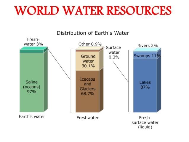
Water is a precious resource that is plentiful on Earth. Approximately 71 per cent of our planet is covered with water, but only 3 per cent of that is fresh water. A very small portion of fresh water is actually accessible for human use, and its availability varies over time and across different locations.
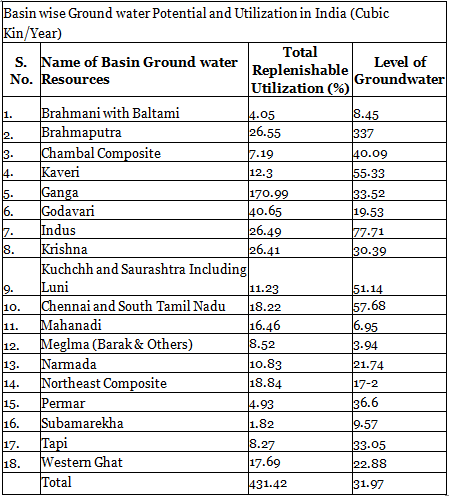
India, which makes up about 2.4 per cent of the world's land area, has around 4 per cent of the world's water resources, supporting about 16 per cent of the global population. The country receives around 4,000 cubic km of water from precipitation each year. However, due to geographical and hydrological challenges, only about 690 cubic km (or 32 per cent. of the available surface water can be used effectively. The total replenishable groundwater resources in India are estimated to be around 432 cubic km, with the Ganga and Brahmaputra basins accounting for about 46 per cent of these resources.
Surface Water Resources
The surface water resources in India are derived from four main sources:
- Rivers
- Lakes
- Ponds
- Tanks
India is home to approximately 10,360 rivers and their tributaries, each longer than 1.6 km. The average annual flow across all river basins in India is estimated to be 1,869 cubic km. However, due to various geographical and hydrological challenges, only about 690 cubic km of this water (approximately 32 per cent. is usable.
The flow of water in a river is influenced by the size of its catchment area and the amount of rainfall it receives. Although the Ganga, Brahmaputra, and Barak rivers cover only one-third of India’s land area, they account for 60 per cent of the country’s surface water resources because of the high rainfall in their catchment areas. In contrast, much of the annual water flow in southern rivers such as the Godavari, Krishna, and Kaveri has been effectively harnessed. There is still significant potential for better water utilization in the Brahmaputra and Ganga basins.
Groundwater Resources
India has a total of about 432 cubic km of replenishable groundwater resources, with the Ganga and Brahmaputra basins contributing approximately 46 per cent of these resources. Groundwater usage is particularly high in the north-western states and certain areas of southern India.
States such as Punjab, Haryana, Rajasthan, and Tamil Nadu exhibit very high levels of groundwater utilization. In contrast, states like Chhattisgarh, Odisha, and Kerala use only a small portion of their groundwater potential. Other states, including Gujarat, Uttar Pradesh, Bihar, Tripura, and Maharashtra, are utilizing their groundwater resources at a moderate level. If current trends continue, the demand for water may exceed available supplies, potentially harming development and leading to social issues.
Water Demand and Utilization
India has traditionally been an agrarian economy, with about two-thirds of its population dependent on agriculture. As a result, enhancing irrigation to increase agricultural production is a primary focus in the Five Year Plans. Various multipurpose river valley projects, including the Bhakra-Nangal, Hirakund, Damodar Valley, Nagarjuna Sagar, and Indira Gandhi Canal Project, have been launched to address this need. Presently, the demand for water in India is predominantly driven by the requirements of irrigation.
Agriculture consumes the vast majority of both surface and groundwater resources, accounting for 89 per cent of surface water and 92 per cent of groundwater. In contrast, the industrial sector utilizes only 2 per cent of surface water and 5 per cent of groundwater. The domestic sector, however, has a larger share of surface water usage at 9 per cent, compared to its groundwater usage. While the agricultural sector's share of total water use is significantly higher than that of other sectors, it is anticipated that the shares of the industrial and domestic sectors will increase as development progresses.
Demand of Water for Irrigation
Water is essential for irrigation in agriculture due to the uneven distribution of rainfall across India. Many regions, especially in North-Western India and the Deccan plateau, experience low rainfall and are susceptible to drought. Most areas are dry during the winter and summer months. Irrigation facilitates multiple cropping and has been proven to improve agricultural productivity compared to un-irrigated land. Furthermore, high-yielding crop varieties demand a consistent moisture supply, which developed irrigation systems can provide. This has significantly contributed to the success of the green revolution in states like Punjab, Haryana, and western Uttar Pradesh.
In these states, over 85 per cent of the net sown area is irrigated, primarily for the cultivation of wheat and rice. Among the total net irrigated area, 76.1 per cent in Punjab and 51.3 per cent in Haryana are irrigated using wells and tube wells. This indicates a substantial reliance on groundwater resources, leading to their depletion in these regions. The data also highlights a high proportion of irrigation through wells and tube wells in the mentioned states.
Water Pollution and Management
The excessive use of groundwater resources has led to a decline in the groundwater table in various states. Particularly, states like Rajasthan and Maharashtra have experienced increased concentrations of fluoride in groundwater due to over-extraction. This practice has also contributed to higher levels of arsenic in certain areas of West Bengal and Bihar.
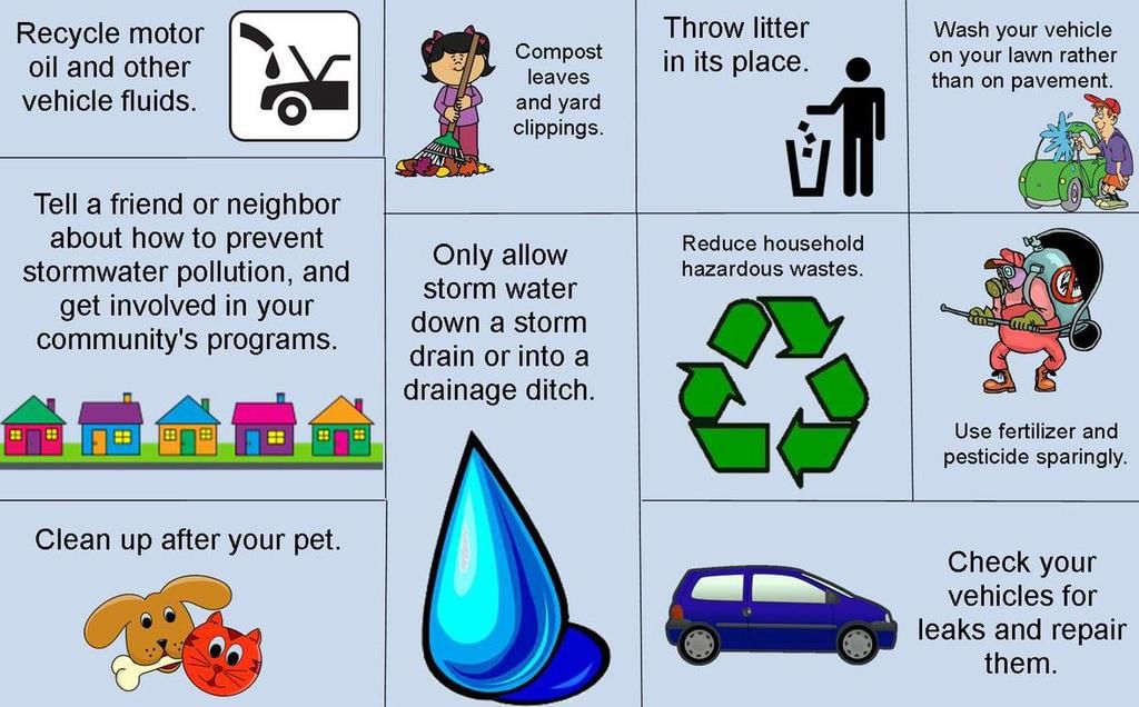
Prevention of Water Pollution: Our available water resources are deteriorating rapidly. Major rivers in the country tend to have better water quality in less populated hilly regions. In contrast, river water in the plains is heavily utilized for:
- Irrigation
- Drinking
- Domestic purposes
- Industrial uses
However, drains carrying agricultural (fertilizers and insecticides), domestic (solid and liquid wastes), and industrial effluents flow into these rivers. The concentration of pollutants in rivers is particularly high during the summer when water flow is low.
The Central Pollution Control Board (CPCB), along with State Pollution Control Boards, has been monitoring the water quality of national aquatic resources at 507 stations. Data from these stations indicate that organic and bacterial contamination remain the primary sources of pollution in rivers. The Yamuna River is often cited as one of the most polluted rivers in the country, especially between Delhi and Etawah.
Other rivers facing severe pollution issues include:
- Sabarmati at Ahmedabad
- Gomti at Lucknow
- Kali
- Adyar
- Cooum (entire stretches)
- Vaigai at Madurai
- Musi of Hyderabad
- Ganga at Kanpur and Varanasi
Groundwater pollution has been attributed to high levels of heavy/toxic metals, fluoride, and nitrates in various regions across the country.
Legislative measures such as the Water (Prevention and Control of Pollution) Act 1974 and the Environment Protection Act 1986 have not been effectively enforced. As a result, in 1997, there were 251 polluting industries located along rivers and lakes.
The Water Cess Act 1977, intended to reduce pollution, has also had limited impact. There is an urgent need to raise public awareness about the importance of water and the repercussions of water pollution. Public knowledge and action can significantly mitigate pollutants from agricultural, domestic, and industrial discharges.
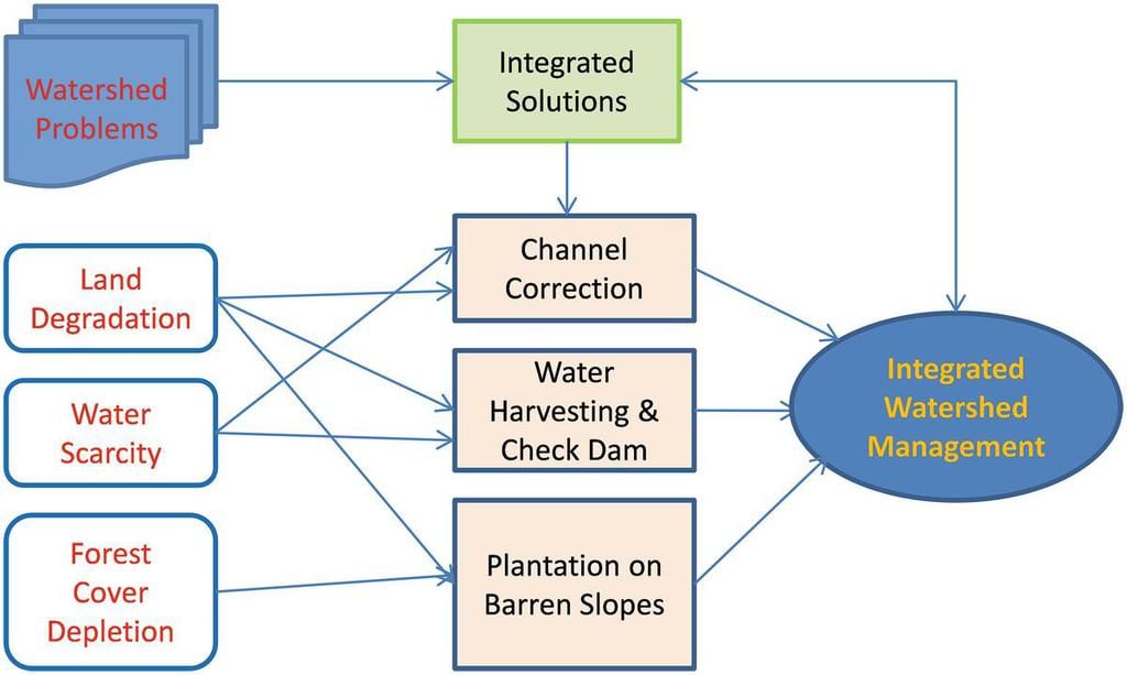
Watershed Management: Watershed management primarily involves the effective management and conservation of surface and groundwater resources. It aims at:
- Preventing runoff
- Storing and recharging groundwater through techniques such as percolation tanks and recharge wells
In a broader context, watershed management encompasses the conservation, regeneration, and prudent use of all natural resources (including land, water, plants, and animals) and human resources within a watershed.
Integrated Watershed Management Plan, Tehri Garhwal (Uttarakhand)
Watershed management aims to balance the use of natural resources with the needs of society, and its success relies heavily on community participation.
Various programmes for watershed development and management have been launched by the Central and State Governments, with some being implemented by non-governmental organisations as well. One such initiative is the Hariyali project, sponsored by the Central Government, which focuses on helping rural communities conserve water for drinking, irrigation, fisheries, and afforestation. This project is carried out by Gram Panchayats with active community involvement.
Community Participation in Water Harvesting
- The Neeru-Meeru (Water and You) programme in Andhra Pradesh and the Arvary Pani Sansad in Alwar, Rajasthan, have emphasised the construction of various water harvesting structures, including percolation tanks, dug-out ponds (Johad), and check dams, with active participation from local communities.
- In Tamil Nadu, the government has mandated the inclusion of water harvesting structures in all new buildings to promote water conservation.
While some watershed development projects have successfully revitalised the environment and the economy, there are only a few success stories, and most programmes are still in their early stages. Raising awareness about the benefits of watershed management is crucial, as this integrated approach can help ensure sustainable water availability.
Rainwater Harvesting
Rainwater harvesting is a method of capturing and storing rainwater for various purposes, including recharging groundwater aquifers. It is a low-cost and environmentally friendly practice aimed at preserving every drop of water by directing rainwater to
- bore wells
- pits
- wells
The benefits of rainwater harvesting include
- Increased water availability
- Prevention of declining groundwater levels
- Improved groundwater quality through the dilution of contaminants such as fluoride and nitrates
- Reduction of soil erosion and flooding
- Prevention of saltwater intrusion in coastal areas when used to recharge aquifers
Various communities across India have been practising rainwater harvesting for a long time. In rural areas, traditional methods involve using surface storage bodies such as
- lakes
- ponds
- irrigation tanks
In Rajasthan, structures known as Kund or Tanka (covered underground tanks) are constructed near homes or villages to store rainwater.
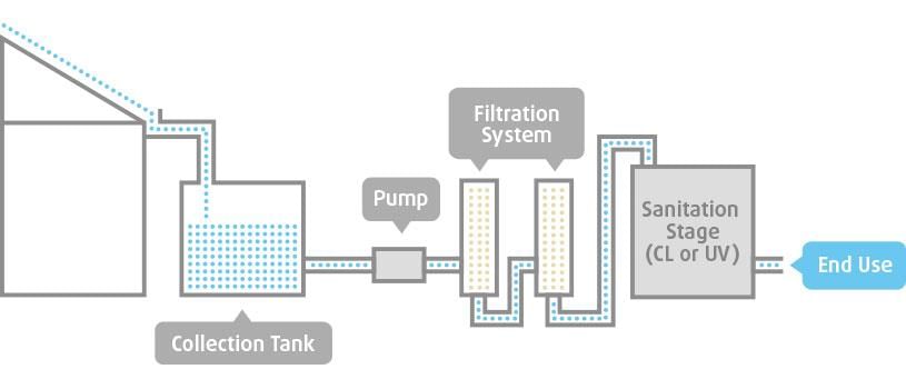
Rainwater Harvesting and Water Management in India
Rainwater harvesting is an effective method to conserve water resources by collecting rainwater from rooftops and open spaces. This technique reduces the reliance on groundwater for domestic use, helping to bridge the demand-supply gap and save energy required for pumping groundwater. Additionally, rainwater harvesting leads to an increase in groundwater levels.
Currently, rainwater harvesting is being implemented on a large scale in various states across India, with urban areas benefiting significantly due to their higher water demand exceeding supply.
Other important measures to address India’s water issues include desalination in coastal regions, management of brackish water in arid areas, and transferring water from surplus to deficit regions through interlinking of rivers. However, the most crucial aspect for individual users, households, and communities is the pricing of water.
Highlights of India’s National Water Policy, 2002
The National Water Policy 2002 outlines water allocation priorities in the following order: drinking water, irrigation, hydro-power, navigation, and industrial and other uses. Key features of the policy include:
- Including a drinking water component in irrigation and multi-purpose projects where no alternative source of drinking water is available.
- Prioritizing drinking water provision for all humans and animals.
- Regulating and limiting the exploitation of groundwater.
- Regular monitoring of surface and groundwater quality.
- Implementing a phased programme to improve water quality.
- Enhancing the efficiency of water utilization across all uses.
- Raising awareness about water as a scarce resource.
- Promoting conservation consciousness through education, regulation, incentives, and disincentives.
|
175 videos|476 docs|193 tests
|
FAQs on NCERT Summary: Soils - 2 - Geography for UPSC CSE
| 1. What are the different layers of soil? |  |
| 2. How does soil formation occur? |  |
| 3. What factors influence soil formation? |  |
| 4. How does soil support plant growth? |  |
| 5. How can soil erosion be prevented? |  |

|
Explore Courses for UPSC exam
|

|


