NCERT Summary: Transport & Communication - 1 | Geography for UPSC CSE PDF Download
| Table of contents |
|
| Transport & Communication |
|
| Border Road Organization (BRO) |
|
| RAIL TRANSPORT |
|
| WATER TRANSPORT |
|
| AIR TRANSPORTATION |
|

Transport & Communication
The use of transport and communication depends upon our need to move things from place of their availability to the place of their use.
1. Road Transport in India:
Overview:
- India has one of the largest road networks globally, spanning over 63 lakh km as of 2025, including highways, expressways, and rural roads.
- 85% of passenger and 70% of freight traffic rely on roads, particularly suitable for shorter distances, with GNSS-based tolling enhancing efficiency.
Historical Background:
- Limited modern road transport in India pre-World War II.
- The 'Nagpur Plan' in 1943 aimed at road development, but implementation challenges persisted.
- Post-Independence, a twenty-year road plan (1961) was introduced, followed by modern initiatives like Bharatmala Pariyojana in 2017.
2. Classification of Roads:
National Highways (NH):
- Roads constructed and maintained by the Central Government.
- Strategic importance for inter-state transport, defense movement, and connecting key locations.
- Managed by the National Highways Authority of India (NHAI) since 1995, with over 1.46 lakh km as of 2025.
- NHs constitute 2.3% of total road length but carry 40% of road traffic, supported by expressways like Delhi-Mumbai Expressway.
State Highways (SH):
- Constructed and maintained by state governments.
- Connect state capitals, district headquarters, and important towns.
- Comprise 4% of the total road length, integrated with PM Gati Shakti for multi-modal connectivity.
District Roads:
- Link District Headquarters with other significant nodes in the district.
- Contribute to 14% of the total road length, upgraded under state-specific schemes.
Rural Roads:
- Vital for connecting rural areas.
- Account for 80% of the total road length in India, bolstered by PMGSY Phase IV.
- Density varies regionally based on terrain characteristics.
Other Roads:
- Border Roads: Constructed by the Border Road Organization (BRO) for strategic and economic development, especially in challenging terrains.
- International Highways: Foster harmonious relationships with neighboring countries, enhancing connectivity with India, e.g., India-Myanmar-Thailand Trilateral Highway.
Border Road Organization (BRO)
Establishment:
- Founded in May 1960 to accelerate economic development and enhance defense preparedness.
- Focus on strategically important roads along the northern and northeastern boundaries.
Achievements:
- Constructed over 61,000 km of roads by March 2025, including climate-resilient infrastructure.
- Notable projects include Atal Tunnel (9.02 km, longest above 10,000 ft) and roads in high-altitude terrains like Chandigarh to Manali and Leh.
Responsibilities:
- Multifaceted construction agency with tasks ranging from road construction to snow clearance in high-altitude areas, supporting projects like IMEC.
4. Road Distribution in India:
Density Variation:
- Uneven distribution with density varying from 12 km in Jammu and Kashmir to 517 km in Kerala (2025).
- National average density is 181 km per 100 sq km, reflecting infrastructure growth.
- Determinants: Nature of terrain and the level of economic development.
Factors Influencing Variation:
- Construction ease and cost play a role; plains have higher density and better road quality compared to hilly and plateau areas.
- Northern and major southern states have higher road density, while the Himalayan region, Madhya Pradesh, and Rajasthan have lower density, though PMGSY bridges gaps.
NATIONAL HIGHWAYS DEVELOPMENT PROJECTS
North-South and East-West Corridors: Completed by 2020, the North-South corridor connects Srinagar in Jammu and Kashmir to Kanyakumari in Tamil Nadu (including Kochi-Salem) with 4,076 km. The East-West Corridor connects Silchar in Assam to Porbandar in Gujarat with 3,640 km, enhanced by Bharatmala’s economic corridors like Amritsar-Jamnagar.
Bharatmala Pariyojana: Launched in 2017, this flagship program targets 83,677 km of highways by 2027, including 34,800 km in Phase I (nearing completion by 2025). It focuses on economic corridors, border roads, and expressways like Delhi-Mumbai Expressway, supporting PM Gati Shakti’s multi-modal vision.
RAIL TRANSPORT
1. History and Overview of Indian Railways:
Inception:
- Indian Railways originated in 1853 with a 34 km line from Bombay to Thane.
Scale and Importance:
- Largest government undertaking in India, with a 100% electrified network by 2024.
- Extensive network spanning 68,000 km as of 2025, including high-speed corridors.
Management Structure:
- Divided into eighteen zones, including South Coast Railway Zone (2019), for efficient management.
- Centralized management system faces challenges due to the vast network, mitigated by IRCTC’s digitalization.
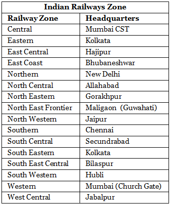
2. Zone-wise Performance:
Railway Zones:
- Eighteen zones established to manage and operate the railway network efficiently, with Vande Bharat trains enhancing connectivity.
- Each zone is responsible for a specific geographic area, integrated with Dedicated Freight Corridors.
Table Data:
- Zone-wise performance data provides insights into operational aspects, including freight and passenger traffic growth post-DFC operationalization.
3. Development of Railway Routes:
Colonial Era Connectivity:
- Initial railway development focused on connecting areas around towns, raw material producing regions, plantations, hill stations, and cantonment towns during British colonial rule.
Post-Independence Expansion:
- After Independence, railway routes extended to other areas, contributing to nationwide connectivity, with 100% electrification by 2024.
Significant Development - Konkan Railway:
- Konkan Railway (1998):
- 760 km track from Roha (Maharashtra) to Mangalore (Karnataka).
- Connects Mumbai and Mangalore along the western coast, now electrified and upgraded for Vande Bharat services.
- Remarkable engineering feat with 146 rivers, 2000 bridges, and 91 tunnels, including the longest tunnels in Asia (6.5 km).
- Joint enterprise of Karnataka, Goa, and Maharashtra governments, a model for PPP in rail infrastructure.
- Konkan Railway (1998):
4. Regional Distribution of Railway Network:
Dense Areas:
- Railways well-developed in areas around towns, raw material production zones, hill stations, and cantonment towns, enhanced by DFCs.
Sparse Areas:
- Relatively less dense network in hill states, northeastern states, central parts of India, and Rajasthan, though Amrit Mahotsav projects improve connectivity.
5. Role of Railways in Mass Transportation:
- Continued Significance:
- Despite other modes, railways remain the primary means of mass transit, with over 100 Vande Bharat trains and Mumbai-Ahmedabad Bullet Train trials by 2025.
6. Rural Roads and Pradhan Mantri Grameen Sadak Yojana:
- Special Impetus:
- Rural roads received focus under the Pradhan Mantri Grameen Sadak Yojana, with Phase IV (2024) targeting 25,000 km of new roads.
- Aim: Connect every village to a major town with an all-season motorable road, supporting rural e-commerce and mobility.
WATER TRANSPORT
1. Importance of Waterways:
Versatility:
- Essential for both passenger and cargo traffic.
- Particularly suitable for heavy and bulky materials, with 24 operational National Waterways by 2025.
- Regarded as the cheapest means of transport, aligned with Sagarmala’s coastal shipping goals.
Fuel Efficiency and Eco-friendliness:
- Water transport is fuel-efficient and environmentally friendly, supporting India’s Net Zero 2070 target.
2. Types of Waterways:
Inland Waterways:
- Traditional mode of transport predating railways.
- Faced competition from road and rail but revitalized under Sagarmala.
- Irrigation diversions affected navigability, addressed by IWAI’s dredging efforts.
- India has 14,500 km of navigable waterways, with 111 National Waterways notified, contributing 2% to transportation by 2025.
- Comprises rivers, canals, backwaters, creeks, etc., with 3,000 km of rivers and 1,200 km of canals operational.
Inland Waterways Authority:
- Established in 1986 for the development, maintenance, and regulation of national waterways.
- 111 inland waterways declared as National Waterways, with 24 operational by 2025 (e.g., NW-1, NW-2, NW-3).
- Additional waterways like NW-4 (Godavari-Krishna) and NW-5 (Mahanadi-Brahmani) upgraded for cargo and tourism.
Significance of Kerala's Backwaters:
- Backwaters (Kadal) in Kerala offer cheap transport and attract tourists, integrated with NW-3.
- Nehru Trophy Boat Race (Vallankali) held in Kerala's backwaters, boosting tourism economy.
National Waterways:
National Waterway Route NW-1 Allahabad to Haldia (Ganga-Bhagirathi-Hooghly river system) NW-2 Sadiya to Dhubri (Brahmaputra river) NW-3 Kollam to Kottapuram (West Coast Canal, Champakara Canal, and Udyogmandal Canal)
3. Oceanic Waterways:
Geographical Overview:
- India has a coastline of approximately 7,517 km, including islands.
- Thirteen major and 200 minor ports support oceanic routes, with Vadhavan Port under development by 2025.
Economic Significance:
- Plays a vital role in India's economy, with 95% of foreign trade volume and 70% by value moving through ocean routes, handling 1,600 million tonnes by 2025.
- Facilitates transportation between islands and mainland, enhanced by Sagarmala’s port modernization.
AIR TRANSPORTATION
Speed and Efficiency:
- Fastest means of movement, reducing travel time significantly.
- Essential for a large country like India with diverse terrain and climatic conditions, supported by UDAN 5.0.
Distance Reduction:
- Plays a crucial role in minimizing distances, enhancing connectivity, with over 150 airports by 2025.
2. Development and Management of Air Transport:
Historical Overview:
- Initiated in 1911 with airmail operations between Allahabad and Naini.
- Significant development post-Independence, with privatization of airports (e.g., Adani Group).
- Airport Authority of India manages 153 airports, including 30 international, domestic, and civil enclaves by 2025.
Corporations in Air Transport:
- Nationalization led to the establishment of Air India and Indian Airlines, with Air India privatized in 2022 under Tata Group.
- Private companies like IndiGo, SpiceJet, and Akasa Air dominate, offering passenger services across 300+ routes.
3. History of Indian Airlines:
Milestones:
- 1911: Launch of air transport between Allahabad and Naini.
- 1947: Major companies like Indian National Airways, Tata Sons Limited, Air Services of India, and Deccan Airways provided air transport.
- 1951: Bharat Airways, Himalayan Aviation Limited, Airways India, and Kalinga Airlines joined services.
- 1953: Nationalization led to the formation of two corporations - Air India International and Indian Airlines (merged into Air India in 2011).
Current Operations:
- Air India (Tata Group) offers international and domestic air services, with fleet expansion targeting 300 aircraft by 2027.
- Domestic movement in 2025 involves 30 million passengers and 25 lakh metric tonnes of cargo, driven by UDAN 5.0.
- Pawan Hans provides helicopter services in hilly areas and is popular among tourists in the northeastern sector, with eVTOL trials planned.
4. Oil and Gas Pipelines:
Convenience and Efficiency:
- Pipelines are efficient for transporting liquids, gases, and even solids converted into slurry over long distances, critical for energy security.
Oil India Limited (OIL):
- Engaged in exploration, production, and transportation of crude oil and natural gas.
- Constructed Asia's first cross-country pipeline (1,157 km) from Naharkatiya oilfield in Assam to Barauni refinery in Bihar, now part of National Gas Grid.
Recent Developments:
- Extensive pipeline network of 22,000 km by 2025, including Urja Ganga (2,655 km) and green hydrogen pipelines under trial.
- Completed pipelines include Salaya-Mathura (1,256 km) and Numaligarh-Siliguri (660 km).
- New projects: Ethanol blending pipelines and Chabahar Port-linked networks for regional energy trade.
5. Communication Networks:
Historical Evolution:
- Evolution from drum beats, smoke signals, and fast runners to modern means like post office, telegraph, printing press, telephone, satellites, and 5G networks.
Modes of Communication:
- Personal Communication System:
- Internet, with 900 million users and 5G covering 90% of India by 2025, is the most effective and advanced means.
- Facilitates direct contact through email, access to vast knowledge, and e-commerce via ONDC and UPI.
- Cost-effective and efficient, with India Post’s digital logistics and Starlink’s rural connectivity trials.
- Personal Communication System:
6. Indian Railways - Three Types based on Rail Breadth:
Broad Gauge:
- Distance between two rails: 1.676 meters (corrected from 1.616 m).
- Dominates with 86% of total length, used by Vande Bharat and Bullet Trains.
Meter Gauge:
- Distance between two rails: One meter.
- Reduced to 10% of total length by 2025 due to gauge conversion to broad gauge.
Narrow Gauge:
- Distance between two rails: 0.762 meters or 0.610 meters.
- Accounts for 2% of total length, primarily for heritage routes like Darjeeling Himalayan Railway.
7. Emerging Transport Technologies:
Green and Futuristic Transport:
- Electric vehicle infrastructure expanded with 10,000 charging stations by 2025 under FAME III.
- Hyperloop trials (e.g., IIT Madras-Virar) and hydrogen fuel cell vehicles align with India’s sustainability goals.
- PM Gati Shakti integrates transport modes, enhancing logistics efficiency for Vision 2047.
|
264 videos|875 docs|232 tests
|
FAQs on NCERT Summary: Transport & Communication - 1 - Geography for UPSC CSE
| 1. What are the different modes of transport mentioned in the article? |  |
| 2. How are roads important for transportation? | |
| 3. What is the role of communication in transportation? | |
| 4. How does the article explain the role of railways in transport? | |
| 5. What are the advantages of waterways as a mode of transport? | |


shortcuts and tricks
,NCERT Summary: Transport & Communication - 1 | Geography for UPSC CSE
,Viva Questions
,Semester Notes
,MCQs
,study material
,Objective type Questions
,Previous Year Questions with Solutions
,Important questions
,Exam
,Sample Paper
,ppt
,NCERT Summary: Transport & Communication - 1 | Geography for UPSC CSE
,Free
,past year papers
,mock tests for examination
,video lectures
,practice quizzes
,Extra Questions
,NCERT Summary: Transport & Communication - 1 | Geography for UPSC CSE
,Summary
;


NCERT Summary: Transport & Communication - 1 Free PDF Download
Importance of NCERT Summary: Transport & Communication - 1
NCERT Summary: Transport & Communication - 1 Notes
NCERT Summary: Transport & Communication - 1 UPSC Questions
Study NCERT Summary: Transport & Communication - 1 on the App
|
© EduRev
|
Education Revolution
|


|


within 7 days!