Indian Geography: Size & Location- 2 | Geography for UPSC CSE PDF Download
| Table of contents |

|
| Types of Weathering |

|
| Physical Weathering Processes |

|
| Chemical Process of Weathering |

|
| Biological Weathering |

|
| Atmosphere |

|
| The Himalayas |

|
Types of Weathering
There are three main types of weathering:
- Physical weathering/Mechanical weathering,
- Chemical weathering,
- Biological weathering.
Physical Weathering Processes
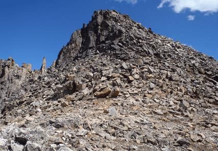 Mechanical weatheringThis process refers to the mechanical disintegration of rocks in which their mineralogical composition is not changed. This is brought about chiefly by temperature changes, e.g., thermal expansion and contraction. The following are some of the important processes of physical weathering.
- Exfoliation: In this case, thin sheets of rock split off owing to differential expansion and contraction during heating and cooling over the diurnal temperature range.
- Crystal growth: The soluble constituents of the rocks or minerals, enter the rocks through fractures and joints, along with water. With the evaporation of water, the solution is precipitated to form crystals or crystalline aggregates and as they grow, they exert large expansive stresses, which help in breaking up some rocks.
- Freezing of water: Water, as we know, expands by about 9.05 per cent in volume when it freezes. The water seeps down into the fracture and under suitable climatic conditions, begins to freeze at the top of the fracture first. As freezing continues, the pressure exerted on the walls becomes more and more intense, which results in widening the existing fracture and new fractures form. This is the dominant mode of weathering, in climates where there is repeated freezing and thawing. This is also known as Frost action.
- Differential expansion: Rock-forming minerals expand when heated, but contract when cooled. Where rock surfaces are exposed daily to intense heating by direct solar rays, alternating with intense cooling by longwave radiation at night, the resulting expansion and contraction of mineral grains tend to break them apart.
The intense heat of forest and bush fires is known to cause rapid flaking and scaling of exposed rock surfaces.
Chemical Process of Weathering
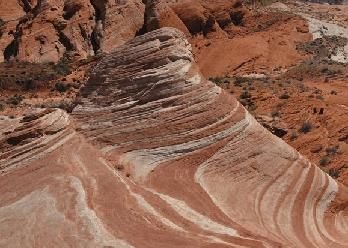 Chemical weathering
- It is also known as mineral alteration and consists of a number of chemical reactions. All these reactions change the original silicate minerals of igneous rock, the primary minerals, into new compounds, the secondary minerals, that are stable in the surface environment.
- Besides, sedimentary and metamorphic rocks are also substantially affected by the chemical processes of weathering. Chemical weathering is more important than mechanical weathering in almost all climatic regions.
Following processes are notably responsible for chemical weathering:
- Oxidation: The presence of dissolved oxygen in the water in contact with mineral surfaces leads to oxidation; which is the chemical union of oxygen atoms with atoms of other metallic elements. Oxygen has a particular affinity for iron compounds and these are among the most commonly oxidised materials.
- Hydration: The chemical union of water with a mineral is called hydration. It is sometimes confused with ‘hydrolysis’, the reaction between water and a compound. The process of hydration is particularly effective on some aluminium bearing minerals, such as feldspar.
- Carbonation: Carbon dioxide is a gas and is a common constituent of the earth’s atmosphere. Rainwater in course of its passage through the atmosphere dissolves some of the carbon dioxide present in the air. It thus turns into a weak acid called carbonic acid, H2CO3 and is the most common solvent acting on the crust. The effect of this process is well noticed in the limestone or chalk areas in the humid regions of the world.
Besides the above, another process known as “Solution” is quite significant in bringing about the chemical weathering of rocks. In this case, some of the minerals get dissolved by water and thus removed in solution, for example, gypsum, halite etc.
1. Exfoliation
2. Oxidation
3. Frost Action
4. Hydration
5. Crystal Growth
Biological Weathering
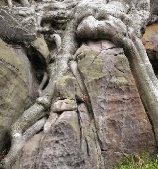 Biological weathering
- This process of weathering is mainly related to the activities of various organisms. Organisms, mainly plants and bacteria, take part in the transformation of rocks at the surface, in the following ways:
(a) Bio-physical processes
(b) Bio-chemical processes.
Bio-physical Processes
- Plant roots, growing between joint blocks and along with minute fractures between mineral grains, exert an expansive force tending to widen those opening and sometimes create new fractures.
- Insects like earth-worm, snails etc. loosen the soil cover and create suitable conditions for the various external agencies to have their own action on the underlying rocks, which ultimately lead to rock weathering.
Bio-chemical Processes
- Sometimes, certain groups of bacteria, algae and mosses break rock-forming silicates down directly, removing from them elements like silicon, potassium, phosphorous, calcium, magnesium, that they need as nutrients. This transformation sometimes occurs on a large scale and is decisive in the alteration of parent rocks and facilitate rock weathering.
- After the death of animals or plants, with their subsequent decay and degeneration, chemically active substances are produced, which are capable of bringing about rock weathering. For example, humic acid which is formed during decay and degeneration of plant life is capable of bringing about rock weathering effectively, to some extent. Question for Indian Geography: Size & Location- 2Try yourself:Due to the death of living beings, active chemical compounds are released into the soil, which will result in rock weathering. This process of weathering comes under which form?View Solution
Atmosphere
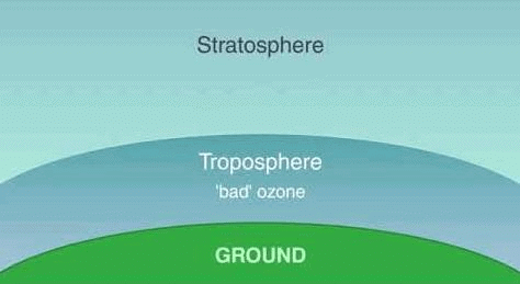
Troposphere
- It roughly extends to a height of 8 km near the poles and about 18 km. at the equator.
- The thickness of the troposphere at the equator is the greatest because heat is transported to great heights by strong convection currents.
- Temperature decreases with height in this layer, roughly at the rate of 1°C for 165 meters of ascent. This is known as the normal lapse rate.
- This layer contains dust particles and over 90% of the earth’s water vapour.
- All vital atmospheric processes leading to various climatic and weather conditions take place in this layer.
- Aviators of jet aeroplanes often avoid this layer due to the presence of bumpy air pockets and fly through tropopause which separates the troposphere from the stratosphere.
Stratosphere
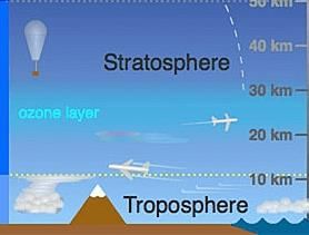 Stratosphere
- Here the air is at rest and movement is almost horizontal. It is an isothermal region and is free of clouds, dust and water vapour.
- Its upper strata are rich in ozone which prevents ultra-violet radiation by absorbing them.
- Up to a height of 20 k.m. temperature remains constant and afterwards, it gradually increases up to a height of 50 km.
Mesosphere
It extends up to a height of 80 km. from the earth’s surface. Temperature decreases with height again and reaches up to 100°C at a height of 80 km.
Ionosphere
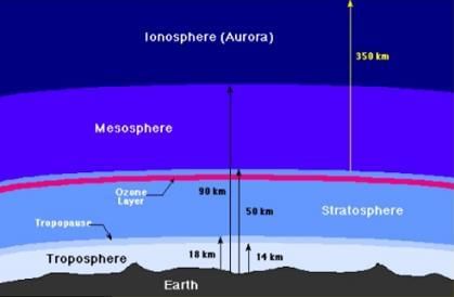 Ionosphere
- It extends up to a height of 150 km. It is a region of electrically charged or ionized air lying next to the mesosphere. It protects us from falling meteorites.
- It reflects Radio waves. It is due to this sphere that the radio waves travel in a curved path and that radio transmission is received by us.
Aurora Borealis
- Aurora comprises an electric discharge and is usually accompanied by a magnetic storm. Because of this electric discharge, the air particles at a higher attitude begin to shine.
- This light in the Northern Hemisphere is called Aurora Borealis and in the southern hemisphere is Aurora Australis.
ground i.e nearest to farthest
1. Ionosphere
2. Troposphere
3. Stratosphere
4. Mesosphere
Insolation
- Insolation is the incoming solar radiation. It is received in the form of short waves. The earth’s surface receives this radiant energy at the rate of two calories per square centimetre per minute.
- Of the total radiant solar energy that strikes the outer surface of the atmosphere, about 51% is able to reach the earth’s surface directly or indirectly (scattered) and is absorbed. The rest is lost through scattering (by gas molecules), reflection (by clouds) and absorption (largely by water vapour) passing through the atmosphere.
- The amount of insolation reaching the earth’s surface and its effectiveness per unit depends upon.
(i) the angle of incidence or the inclination of sun’s rays;
(ii) the duration of sun-shine or the length of the day, and
(iii) transparency of the atmosphere.
Factors controlling temperature:
- Latitude
- Differential Heating of land and water
- Winds
- Ocean currents
- Attitude
- Aspect
- Cloud cover, etc.
Temperature Anomaly
- The difference between the mean temperature of any place and the mean temperature of its parallel is called the temperature anomaly or thermal anomaly. It thus expresses, deviation from the normal.
- The largest anomalies occur in the Northern Hemisphere and the smallest in the Southern Hemisphere.
- The anomaly is said to be negative when the temperature at a place is less than the expected temperature of the latitude and positive when the temperature is more than the expected temperature of the latitude.
- For the year as a whole, the anomalies are negative over the continents from about 40° latitude towards the poles and positive towards the equator.
- Oceans, the anomalies are positive poleward from about 40° latitude and negative towards the equator.
Pressure
Atmospheric pressure depends primarily on three factors:- Altitude,
- Temperature,
- Earth Rotation
Combined Influence of Rotation and Temperature on Pressure
- Low temperatures at the poles result in the contraction of air and hence the development of high pressure.
- High temperatures along with the equator result in the expansion of air and hence the development of low pressure. This is called the Doldrums Low Pressure.
- Air blowing away from the poles crosses parallels that are getting longer. It, therefore, spreads out to occupy greater space, that is, it expands and its pressure falls. These low pressure belts become noticeable along parallels 60° N and 60° S. As air moves away from the poles, more air moves in from higher levels to take its place. Some of this comes from the rising low pressure air in latitudes 60° N and 60° S.
- Air rising at the equator spreads out and moves towards the poles. As it does so it crosses parallels which are getting shorter and it has to occupy less space. It contracts and its pressure rises. This happens near latitudes 30° N and 30° S and in these latitudes the air begins to sink, thus, building up the high pressure belts of these latitudes. These are called the Horse Latitude High Pressures.
Polar Winds
- They blow from the Polar High Pressures to the Temperate Low Pressures.
- They are better developed in the Southern Hemisphere than in the Northern Hemisphere.
- They are irregular in the Northern Hemisphere.
Westerlies
- They blow from the Horse Latitudes to the Temperate Low Pressures.
- They are deflected to the right to become the S. Westerlies in the Northern Hemisphere and to the left to become the N. Westerlies in the Southern Hemisphere.
- They are variable in both direction and strength. They contain depressions.
Trade Wind
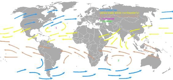 Trade winds
- The word ‘trade’ comes from the Saxon word tredan which means to tread or follow a regular path.
- They blow from the Horse Latitudes to the Doldrums.
- They are deflected to the right to become the N.E. Trades in the Northern Hemisphere and to the left to become the S.E. Trades in the Southern Hemisphere.
- They are very constant in strength and direction.
- They sometimes contain intense depressions.
The Himalayas
The word Himalaya means the abode of snow, as most of its higher peaks are covered with perpetual snow. They are the youngest and the highest folded mountains on the earth, rising to over 8,000 m above the sea level, which run in an east-west direction along the northern boundary of India for 2,400 km and are 240-500 km broad. Their real stretch is between the Indus and the Brahmaputra, thus forming India’s northern frontier from Jammu and Kashmir to Arunachal Pradesh. The Himalayas comprise three almost parallel fold ranges interspersed with deep valleys and extensive plateaus.
The Himadri or the Greater Himalayas
- This is the innermost (northernmost), loftiest and most continuous of the Himalayan ranges with an average height of 6,000 m and always covered with snow. The alpine zone (4,800m and above) vegetation comprises rhododendrons, trees with crooked and twisted stems, thick shrubs with a variety of beautiful flowers and grass.
- Some of the world’s loftiest peaks are found in the greater Himalayas such as Mt. Everest (8,848m, located in Nepal, highest peak in the world), Mt. Godwin Austin or K2 (8,611m, located in India but under Pakistan occupational, Kanchanjunga (8,596 m, in India), Dhaulagiri (8,166 m, in Nepal), Nanga Parbat (8,126m, in India), Nanda Devi (7,817 m, in India) etc.
- Few passes, though at a very high elevation (over 4,500 m) and snowbound for most of the year, occur in these ranges such as Bara Lapcha La and shipli La (Himachal Pradesh), Thaga la, Niti and Lipu Lekh; (UP), Nathula and Jelep La (Sikkim), and Brazil and Jogila (Kashmir)etc.
The Himachal or the Lesser or Middle Himalayas
- Lying to the north of Shivaliks, they have an averages elevation of about 3,500-5000m with an average width throughout the year. The southern slopes are rugged and bare while northern slopes are gentler and have thick to 2,400 m elevation, coniferous forests are found at 2,400 to 3,000 m elevation and in lower slopes are found chir, deodar, blue pines, oak and magnolia.
- Some of the important ranges of the Lesser Himalayas are Pir Panjal, Nag Tiba, Mahabharat and Mussoorie range. These are snow-capped but less inaccessible. Some of the important hill stations of the Himachal range are Chakrata, Mussoorie, Shimla, Ranikhet, Nainital, Almora and Darjeeling, all situated at a height between 1,500 m and 2,000 m above sea level.
The Shivalik or Outer Himalayas
- They are the outermost range of the Himalayas made up mostly of tertiary sediments brought by rivers from the main Himalayan ranges. They consist of foot-hills running to the south of Himachal from Jammu and Kashmir to Arunachal Pradesh.
- They are 1,000 to 1,500 m high with a width ranging from 15 to 50 km. The region is mostly ill-drained (like that of Terai) but cooled and finely wooded. Valleys, termed duns, separate the Sivalik range from the Himachal. Some of the duns in these ranges are Udhampur and Kotli valleys in Jammu and Dehradun, Kota, Patli and Chaukhamba valleys in UP.
The Trans Himalayas or Tibetan Himalayas
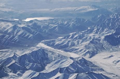 Trans Himalayas
- It comprises the Karakoram and the Kailash range. The trans-Himalaya consists of lofty peaks and glaciers. Some important peaks are K2, the highest peak (8,611m), Hidden Peak (8,068m), Broad Peak.
Significance of Himalayas
The Himalayas are of great significance for the land and people of the subcontinent.- Physical Barrier: The Himalayas act as a physical barrier between the subcontinent.
- Birthplace of Rivers: The massive snowfields and glaciers of the Himalayas are sources of many perennial rivers upon whose water depends on much of irrigation and hydroelectric power of the Indo-Gangetic plain. The silt brought by these rivers has made the Indo-Gangetic plain very fertile, making it one of the most densely populated regions in the world.
- Influence on Climate: The Himalayas protect the Indo-Gangetic plain from the bitterly cold winds which blow from Central Asia and Tibet during winter. It compels the rain-bearing winds blowing from the sea in the south to shed all their load of rain on the Northern Plain.
- Flora and Fauna: The slopes of these mountains are forested and have valuable resources of timber and other useful products. These forests also provide shelter to a wide variety of wildlife which is rarely seen anywhere else.
- Mineral Resources: The Himalayas have commercially valuable minerals such as copper, lead, zinc, bismuth, antimony, nickel, cobalt and tungsten. They are also the storehouse of precious and semi-precious stones. Coal and petroleum are the other mineral fuels found in this region.
- Other Economic Resources: Green pastures of the lower Himalayas have enabled sheep and goat rearing an important occupation. Sericulture is also carried on here.
- Tourist Abode: When the neighbouring lands are suffering from scorching heat in summer, the lower and upper range of the Himalayas, because of their height, enjoy a cool and pleasant climate thus attracting a large number of tourists during the spring and summer seasons.
|
175 videos|472 docs|197 tests
|
FAQs on Indian Geography: Size & Location- 2 - Geography for UPSC CSE
| 1. What are the different types of weathering? |  |
| 2. What is physical weathering? |  |
| 3. How does chemical weathering occur? |  |
| 4. What is biological weathering? |  |
| 5. How does the atmosphere contribute to weathering? |  |

|
Explore Courses for UPSC exam
|

|
