Drainage System Class 11 Geography
| Table of contents |
|
| Introduction |
|
| Drainage Systems of India |
|
| The River Systems of the Himalayan Drainage |
|
| The Peninsular Drainage System |
|
| Extent of Usability of River Water |
|

Introduction
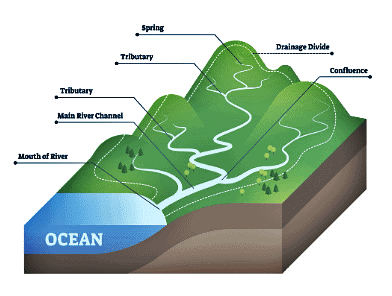
- Drainage refers to the movement of water through specific channels, and when these channels are collected together, they form a drainage system. The pattern of drainage in a particular area is influenced by various factors, including historical geology, rock types, landscape features, slope, water volume, and the frequency of water flow.
- A river gathers water from a region known as its catchment area. The area drained by a river and its smaller streams is called a drainage basin. The boundary that separates different drainage basins is known as a watershed. Large rivers have catchments called river basins, while smaller streams are often referred to as watersheds, which are typically smaller in size compared to basins.
- The Indian drainage system can be divided into two main types:
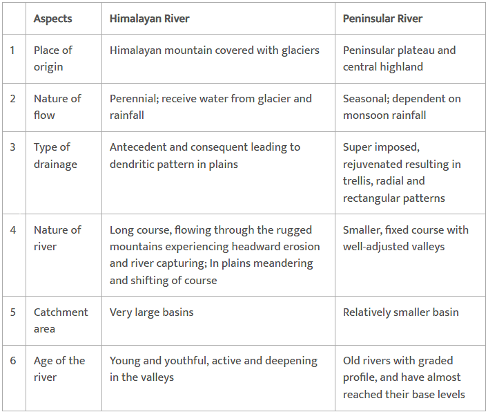
i) Himalayan drainage - developed over a long period and includes the basins of the Ganga, Indus, and Brahmaputra rivers. These rivers are permanent because they receive water from both melting snow and rainfall.
ii) Peninsular drainage - mainly consists of rivers that rely on rainfall and are usually temporary. - River basins and watersheds function with a sense of unity, meaning that changes in one part can affect the entire basin or watershed. This interconnectedness is crucial for understanding how drainage systems operate.
Important Drainage Patterns
The drainage pattern that resembles tree branches is called dendritic, such as the rivers in the northern plains. When rivers originate from a hill and flow in different directions, the drainage pattern is known as radial, as observed with rivers from the Amarkantak range.
- Based on the direction of water flow towards the sea, drainage systems are categorized into two groups:
i) Arabian Sea drainage
ii) Bay of Bengal drainage
These systems are separated by the Delhi ridge, the Aravalis, and the Sahyadris. Approximately 77 percent of the drainage area, including rivers like the Ganga, Brahmaputra, and Mahanadi, flows into the Bay of Bengal. In contrast, 23 percent, including rivers like the Indus, Narmada, Tapi, Mahi, and Periyar, drain into the Arabian Sea.
- Regarding the size of watersheds, India’s drainage basins are classified into three categories:
i) Major river basins - with over 20,000 sq. km of catchment area, including 14 basins like the Ganga, Brahmaputra, and Narmada;
ii) Medium river basins - with areas between 2,000-20,000 sq. km, comprising 44 river basins like the Kalindi and Periyar;
iii) Minor river basins - with areas smaller than 2,000 sq. km, including several rivers in low rainfall regions.
Drainage Systems of India
Indian drainage system consists of a large number of small and big rivers. It is the outcome of the evolutionary process of the three major physiographic units and the nature and characteristics of precipitation.
On the basis of the mode of origin, nature and characteristics, the Indian drainage may also be classified into two main types
1. Himalayan Drainage
2.Peninsular Drainage,
The Himalayan Drainage
- The rivers in this region create impressive features such as giant gorges, V-shaped valleys, rapids, and waterfalls as they flow through the mountains.
- When these rivers enter the plains, they form various depositional features including flat valleys, ox-bow lakes, and flood plains.
- Major rivers in this system include the Ganga, Indus, and Brahmaputra rivers.
- These rivers are perennial, meaning they are constantly supplied by both melting snow and precipitation.
Evolution of the Himalayan Drainage
- Geologists believe that a mighty river called Shiwalik or Indo-Brahma traversed the entire longitudinal extent of the Himalaya from Assam to Punjab and onwards to Sind, and finally discharged into the Gulf of Sind near lower Punjab during the Miocene period some 5-24 million years ago.
- The evidence for this theory lies in the continuous deposits of sand, silt, clay, and boulders found along the Shiwalik, indicating its past presence.
- Over time, the Indo-Brahma Riverwas split into three major drainage systems:
- The Brahmaputra River in Assam, along with its tributaries in the east.
- The Ganga River and its tributaries in the central region.
- The Indus River and its five tributaries in the western area.
- This division is thought to have occurred due to geological changes during the Pleistocene epoch, particularly the uplift of the Potwar Plateau, which acted as a natural barrier separating the Indus and Ganga drainage systems.
The River Systems of the Himalayan Drainage
The Himalayan drainage consists of several river systems but the following are the major river systems
The Indus System
- It is one of the largest river basins of the world, covering an area of 11,65,000 sq. km (in India it is 321, 289 sq. km and a total length of 2,880 km (in India 1,114 km).
- It enters into Pakistan near Chillar in the Dardistan region. Find out the area known as Dardistan.
- The Indus also known as the Sindhu, is the westernmost of the Himalayan rivers in India.
- Tributaries such as the Shyok, the Gilgit, the Zanskar, the Hunza, the Nubra, the Shigar, the Gasting and the Dras.
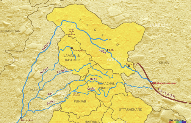
- It originates from a glacier near Bokhar Chu (31 °15' N latitude and 81 °40' E longitude) in the Tibetan region at an altitude of 4,164 m in the Kailash Mountain range.
- In Tibet, it is known as ‘Singi Khamban; or Lion’s mouth. After flowing in the northwest direction between the Ladakh and Zaskar ranges, it passes through Ladakh and Baltistan.
- It cuts across the Ladakh range, forming a spectacular gorge near Gilgit in Jammu and Kashmir.
- The other important tributaries joining the right bank of the Indus are the Khurram, the Tochi, the Gomal, the Viboa and the Sangar. They all originate in the Sulaiman ranges.
The Ganga System
- The Ganga river system is the largest in India having a number of perennial and nonperennial rivers originating in the Himalayas in the north and the Peninsula in the south, respectively.
- The Ganga is the most important river of India both from the point of view of its basin and cultural significance. It rises in the Gangotri glacier near Gaumukh (3,900 m) in the Uttarkashi district of Uttarakhand. Here, it is known as the Bhagirathi.
- It cuts through the Central and the Lesser Himalayas in narrow gorges.
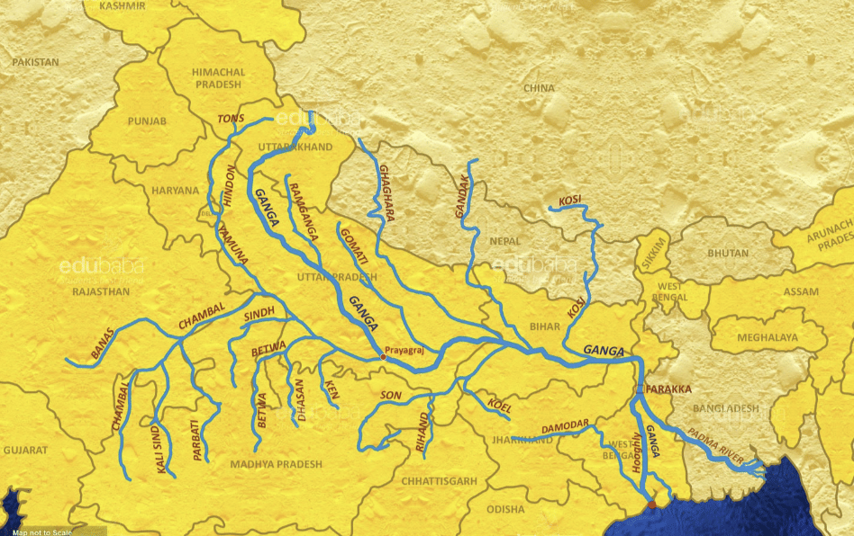
- At Devprayag, the Bhagirathi meets the Alaknanda, hereafter, it is known as the Ganga.
- The other tributaries of Alaknanda such as the Pindar joins it at Karna Prayag while Mandakini or Kali Ganga meets it at Rudra Prayag.
- The Ganga enters the plains at Haridwar. From here, it flows first to the south, then to the south-east and east before splitting into two distributaries, namely the Bhagirathi and the Hugli. The river has a length of 2,525 km. It is shared by Uttarakhand (110 km) and Uttar Pradesh (1,450 km), Bihar (445 km) and West Bengal (520 km).
- The Ganga basin covers about 8.6 lakh sq. km area in India alone.
- The river finally discharges itself into the Bay of Bengal near the Sagar Island.
The Namami Gange Programme, launched in 2014, aims to rejuvenate the Ganga by reducing pollution and conserving its ecosystem. Its focus areas include sewage treatment, riverfront development, surface cleaning, biodiversity, afforestation, public awareness, industrial effluent monitoring, and transforming Ganga-adjacent villages (Ganga Gram).
The Brahmaputra System
- The Brahmaputra, one of the largest rivers of the world, has its origin in the Chemayungdung glacier of the Kailash range near the Mansarovar lake.
- The Rango Tsangpo is the major right bank tributary of this river in Tibet. It emerges as a turbulent and dynamic river after carving out a deep gorge in the Central Himalayas near Namcha Barwa (7,755 m). The river emerges from the foothills under the name of Siang or Dihang.
- In Bangladesh, the Tista joins it on its right bank from where the river is known as the Yamuna. It finally merges with the river Padma, which falls in the Bay of Bengal.
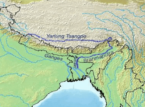
- The Brahmaputra is well-known for floods, channel shifting and bank erosion. This is due to the fact that most of its tributaries are large, and bring a large quantity of sediments owing to heavy rainfall in its catchment area. It enters India west of Sadiya town in Arunachal Pradesh.
- The Brahmaputra receives numerous tributaries in its 750 km long journey through the Assam valley. Its major left bank tributaries are the Burhi Dihing and Dhansari (South) whereas the important right bank tributaries are the Subansiri, Kameng, Manas and Sankosh. The Brahmaputra enters into Bangladesh near Dhubri and flows southward.
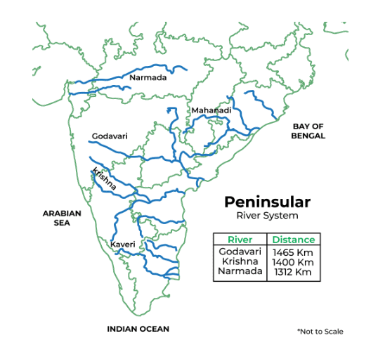
The Peninsular Drainage System
- The Peninsular drainage system is older than the Himalayan one. This is evident from the broad, largely-graded shallow valleys, and the maturity of the rivers.
- The Western Ghats running close to the western coast act as the water divide between the major Peninsular rivers, discharging their water in the Bay of Bengal and as small rivulets joining the Arabian Sea.
- Most of the major Peninsular rivers except Narmada and Tapi flow from west to east. The Chambal, the Sind, the Betwa, the Ken, the Son, originating in the northern part of the Peninsula belong to the Ganga river system.
- Peninsular rivers are characterised by fixed course, absence of meanders and non-perennial flow of water. The Narmada and the Tapi which flow through the rift valley are, however, exceptions.
The Evolution of Peninsular Drainage System
Three major geological events in the distant past have shaped the present drainage systems of Peninsular India:
- Subsidence of the western flank of the Peninsula leading to its submergence below the sea during the early tertiary period. Generally, it has disturbed the symmetrical plan of the river on either side of the original watershed.
- Slight tilting of the Peninsular block from northwest to the southeastern direction gave orientation to the entire drainage system towards the Bay of Bengal during the same period.
- The upheaval of the Himalayas when the northern flank of the Peninsular block was subjected to subsidence and the consequent trough faulting. The Narmada and The Tapi flow in trough faults and fill the original cracks with their detritus materials. Hence, there is a lack of alluvial and deltaic deposits in these rivers.
River Systems of the Peninsular Drainage
The Mahanadi
Originating near Sihawa in the Raipur district of Chhattisgarh, the Mahanadi river flows through the state of Odisha before emptying into the Bay of Bengal. The river stretches 851 kilometers and has a catchment area of approximately 1.42 lakh square kilometers.
- The basin of the Mahanadi is shared between Madhya Pradesh, Chhattisgarh, and Odisha.
- The river's basin is 53 percent located in Madhya Pradesh and Chhattisgarh, while 47 percent is in Odisha.
The Mahanadi river is known for its significant role in irrigation and agriculture in the region.
The Godavari
- The Godavari river is the longest river in Peninsular India, measuring 1,465 kilometers in length.
- It originates in the Nasik district of Maharashtra and flows eastward into the Bay of Bengal.
- The Godavari river basin covers an area of approximately 3.13 lakh square kilometers.
- The basin is distributed as follows: 49 percent in Maharashtra, 20 percent in Madhya Pradesh and Chhattisgarh, and the remaining portion in Andhra Pradesh.
- Major tributaries of the Godavari include the Penganga, Indravati, Pranhita, and Manjra rivers.
- The Godavari river is prone to significant flooding, especially in its lower reaches south of Polavaram, where it forms a picturesque gorge.
The Krishna
- The Krishna river is the second-largest east-flowing river in India, measuring 1,401 kilometers in length.
- It originates near Mahabaleshwar in the Sahyadri mountain range and flows eastward into the Bay of Bengal.
- The catchment area of the Krishna river is divided among three states: 27 percent in Maharashtra, 44 percent in Karnataka, and 29 percent in Andhra Pradesh.
- Major tributaries of the Krishna river include the Koyna, Tungabhadra, and Bhima rivers.
The Kaveri
- The Kaveri river originates in the Brahmagiri hills of Kodagu district in Karnataka, at an elevation of 1,341 meters.
- The river stretches 800 kilometers and drains an area of approximately 81,155 square kilometers.
- The catchment area of the Kaveri basin is distributed as follows: 3 percent in Kerala, 41 percent in Karnataka, and 56 percent in Tamil Nadu.
- The upper region of the Kaveri basin receives rainfall during the southwest monsoon (summer), while the lower region receives rainfall during the northeast monsoon (winter).
- This unique rainfall pattern allows the Kaveri river to maintain a relatively stable flow throughout the year, with less fluctuation compared to other Peninsular rivers.
- Important tributaries of the Kaveri include the Kabini, Bhavani, and Amravati rivers.
The Narmada
- The Narmada river originates on the western side of the Amarkantak plateau at an elevation of approximately 1,057 meters and flows through a rift valley between the Satpura and Vindhyan mountain ranges.
- The river passes through the Dhuandhar waterfall near Jabalpur and travels approximately 1,312 kilometers before meeting the Arabian Sea south of Bharuch, forming a wide 27-kilometer-long estuary.
- The catchment area of the Narmada river is around 98,796 square kilometers.
- The Sardar Sarovar Project, a major water resource project, is built on this river.
The Tapi
- The Tapi river originates from Multai in the Betul district of Madhya Pradesh.
- The river flows westward for approximately 724 kilometers and drains an area of about 65,145 square kilometers.
- The basin of the Tapi river is distributed as follows: 79 percent in Maharashtra, 15 percent in Madhya Pradesh, and 6 percent in Gujarat.
Extent of Usability of River Water
Variability in Water Distribution: Perennial rivers flow year-round, while non-perennial rivers lack water in dry seasons. Excess water during the rainy season often causes floods.
Management Issues: Problems stem more from poor water management than from water scarcity, affecting how floods and droughts are addressed simultaneously.
Inter-Basin Water Transfer: Suggests transferring water from surplus basins to deficit ones and explores existing schemes for inter-basin linkage.
Challenges of River Linking: Highlights logistical challenges, including terrain unevenness, and questions the availability of surplus water for consistent transfer.
Pollution and Usage Problems: Discusses river water pollution from urban, industrial, and ritual sources, and ranks issues like water quantity, pollution, silt, and uneven flow.
Clean-up Initiatives: References major efforts like the Ganga Action Plan and suggests organizing a debate and creating a write-up on river cleanliness initiatives.
|
70 videos|289 docs|44 tests
|
FAQs on Drainage System Class 11 Geography
| 1. What are the major river systems in the Himalayan drainage of India? |  |
| 2. How does the Peninsular drainage system differ from the Himalayan drainage system? | |
| 3. What factors affect the usability of river water in India? | |
| 4. What are the implications of river pollution on the drainage systems in India? | |
| 5. Why is it important to study the drainage systems of India? | |


ppt
,mock tests for examination
,Exam
,Viva Questions
,Drainage System Class 11 Geography
,practice quizzes
,shortcuts and tricks
,study material
,Summary
,Important questions
,Previous Year Questions with Solutions
,Drainage System Class 11 Geography
,Drainage System Class 11 Geography
,Objective type Questions
,past year papers
,Extra Questions
,MCQs
,Sample Paper
,Free
,video lectures
,Semester Notes
;


Revision Notes - Drainage System Free PDF Download
Importance of Revision Notes - Drainage System
Revision Notes - Drainage System
Revision Notes - Drainage System Humanities/Arts Questions
Study Revision Notes - Drainage System on the App
|
© EduRev
|
Education Revolution
|


|


