Class 10 Exam > Class 10 Notes > Geography for GCSE/IGCSE > River Landforms
River Landforms | Geography for GCSE/IGCSE - Class 10 PDF Download

River landscape characteristics
- The changes in river channel characteristics lead to alterations in the river landscape.
- Upland and lowland regions of rivers exhibit distinct landforms.
- Upland Features:
- Waterfalls
- Gorges
- V-shaped valleys
- Interlocking spurs
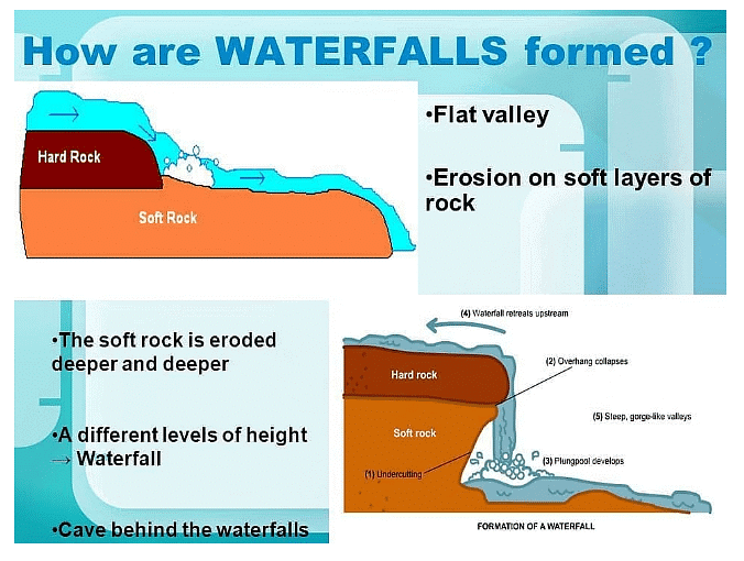
Waterfalls and gorges
- Waterfalls form when there's a descent in the river bed from one level to another.
- This descent often occurs due to variations in rock hardness, where hard rock overlays softer rock.
- The primary erosional processes involved are hydraulic action and abrasion.
- Soft rock erodes more rapidly, creating an undercut beneath the hard rock, resulting in a plunge pool.
- Subsequently, an overhang of hard rock develops, eventually collapsing over time.
- The collapse contributes to the deepening of the plunge pool through increased abrasion.
- The cycle repeats, causing the waterfall to retreat upstream, leaving behind a steep-sided gorge.
Question for River LandformsTry yourself: Which erosional processes are primarily involved in the formation of waterfalls and gorges in river landscapes?View Solution
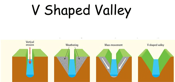
V-shaped valleys
- Vertical erosion is the primary force shaping the upper course of a river. It involves the downward cutting into the riverbed, gradually deepening the river channel.
- Weathering and mass movement processes contribute to the collapse of materials from the valley sides into the river, leading to the formation of a steep, V-shaped valley.
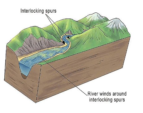
Interlocking spurs
- Meandering of the river channel begins in the upper course.
- Erosion occurs primarily on the outer side of the bends.
- In upland regions, this erosion process shapes interlocking spurs.
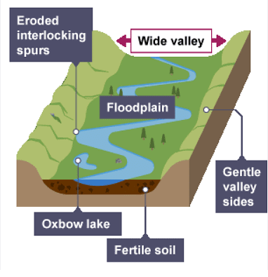
Lowland features
- Meanders
- Ox-bow lakes
- Floodplains
- Levees
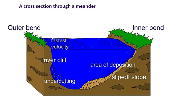
Meanders
- In lowland regions, lateral erosion prevails.
- Meanders expand in size over time.
- The swiftest water flow, known as the thalweg, occurs on the outer side of the river bends, promoting erosion:
- This erosion creates an undercut along the riverbank, resulting in a river cliff.
- Subsequently, the riverbank collapses, causing the meander's edge to advance outward.
- Conversely, the slowest flow occurs on the inner side of the river bends, leading to deposition:
- Deposits accumulate, forming a slip-off slope.
- The interplay of deposition and erosion causes the meander to migrate across the valley.
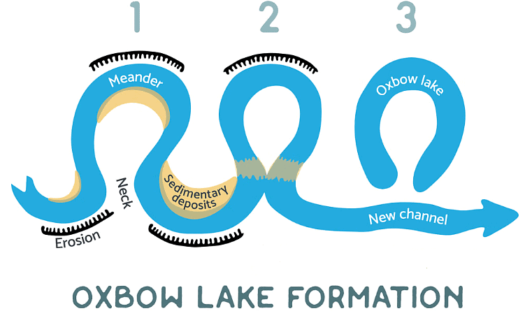
Oxbow lakes
- Meander size typically enlarges as distance downstream increases.
- Erosion along the outer bends can eventually create a meander neck.
- During floods, the river may breach the meander neck, creating a straighter path for water.
- Reduced water flow at the entry and exit points of the meander results in deposition.
- Eventually, the meander may become isolated from the main river channel, forming an oxbow lake.
Floodplains and Levees
- Floodplains are level areas of land situated on both sides of a river.
- The movement of meanders contributes to the creation of floodplains.
- Elevated discharge can result in the river overflowing its banks.
- As water spreads over the floodplain, a larger portion comes into contact with the land surface.
- Enhanced friction slows down the water's velocity, leading to gradual deposition of material across the floodplain, thereby elevating its height.
- Initially, the heaviest materials are deposited nearest to the river channel, forming natural embankments known as levees.
Question for River LandformsTry yourself: What is the primary force shaping the upper course of a river?View Solution
The document River Landforms | Geography for GCSE/IGCSE - Class 10 is a part of the Class 10 Course Geography for GCSE/IGCSE.
All you need of Class 10 at this link: Class 10
|
55 videos|68 docs|78 tests
|
FAQs on River Landforms - Geography for GCSE/IGCSE - Class 10
| 1. What are some common lowland features found in river landscapes? |  |
Ans. Some common lowland features found in river landscapes include floodplains, meanders, oxbow lakes, and levees.
| 2. How do meanders form in river landscapes? | |
Ans. Meanders form in river landscapes due to the erosion on the outer bank of a river bend and deposition on the inner bank, causing the river to curve and form loops.
| 3. What is the significance of levees in river landscapes? | |
Ans. Levees in river landscapes are natural embankments that form along the banks of rivers during flooding, helping to contain the water within the river channel and protecting surrounding areas from flooding.
| 4. How do oxbow lakes form in river landscapes? | |
Ans. Oxbow lakes form in river landscapes when a meander loop is cut off from the main river channel due to erosion and sediment deposition, creating a curved lake.
| 5. What role do floodplains play in river landscapes? | |
Ans. Floodplains in river landscapes are flat, fertile areas that are periodically inundated by river flooding, providing important habitats for wildlife and allowing for the deposition of nutrient-rich sediments.
About this Document

Oct 02, 2025
Last updated
Related Exams
Document Description: River Landforms for Class 10 2025 is part of Geography for GCSE/IGCSE preparation.
The notes and questions for River Landforms have been prepared according to the Class 10 exam syllabus. Information about River Landforms covers topics
like River landscape characteristics, Lowland features and River Landforms Example, for Class 10 2025 Exam. Find important definitions, questions, notes, meanings, examples, exercises and tests below for River Landforms.
Introduction of River Landforms in English is available as part of our Geography for GCSE/IGCSE
for Class 10 & River Landforms in Hindi for Geography for GCSE/IGCSE course.
Download more important topics related with notes, lectures and mock test series for Class 10
Exam by signing up for free. Class 10: River Landforms | Geography for GCSE/IGCSE - Class 10
Description
Full syllabus notes, lecture & questions for River Landforms | Geography for GCSE/IGCSE - Class 10 - Class 10 | Plus excerises question with solution to help you revise complete syllabus for Geography for GCSE/IGCSE | Best notes, free PDF download
Information about River Landforms
In this doc you can find the meaning of River Landforms defined & explained in the simplest way possible. Besides explaining types of
River Landforms theory, EduRev gives you an ample number of questions to practice River Landforms tests, examples and also practice Class 10
tests

Related Searches
Important questions
,video lectures
,shortcuts and tricks
,River Landforms | Geography for GCSE/IGCSE - Class 10
,Viva Questions
,Sample Paper
,River Landforms | Geography for GCSE/IGCSE - Class 10
,Semester Notes
,River Landforms | Geography for GCSE/IGCSE - Class 10
,Exam
,MCQs
,study material
,past year papers
,Objective type Questions
,Extra Questions
,practice quizzes
,Summary
,Free
,mock tests for examination
,ppt
,Previous Year Questions with Solutions
;


Additional Information about River Landforms for Class 10 Preparation
River Landforms Free PDF Download
The River Landforms is an invaluable resource that delves deep into the core of the Class 10 exam.
These study notes are curated by experts and cover all the essential topics and concepts, making your preparation more efficient and effective.
With the help of these notes, you can grasp complex subjects quickly, revise important points easily,
and reinforce your understanding of key concepts. The study notes are presented in a concise and easy-to-understand manner,
allowing you to optimize your learning process. Whether you're looking for best-recommended books, sample papers, study material,
or toppers' notes, this PDF has got you covered. Download the River Landforms now and kickstart your journey towards success in the Class 10 exam.
Importance of River Landforms
The importance of River Landforms cannot be overstated, especially for Class 10 aspirants.
This document holds the key to success in the Class 10 exam.
It offers a detailed understanding of the concept, providing invaluable insights into the topic.
By knowing the concepts well in advance, students can plan their preparation effectively.
Utilize this indispensable guide for a well-rounded preparation and achieve your desired results.
River Landforms Notes
River Landforms Notes offer in-depth insights into the specific topic to help you master it with ease.
This comprehensive document covers all aspects related to River Landforms.
It includes detailed information about the exam syllabus, recommended books, and study materials for a well-rounded preparation.
Practice papers and question papers enable you to assess your progress effectively.
Additionally, the paper analysis provides valuable tips for tackling the exam strategically.
Access to Toppers' notes gives you an edge in understanding complex concepts.
Whether you're a beginner or aiming for advanced proficiency, River Landforms Notes on EduRev are your ultimate resource for success.
River Landforms Class 10 Questions
The "River Landforms Class 10 Questions" guide is a valuable resource for all aspiring students preparing for the
Class 10 exam. It focuses on providing a wide range of practice questions to help students gauge
their understanding of the exam topics. These questions cover the entire syllabus, ensuring comprehensive preparation.
The guide includes previous years' question papers for students to familiarize themselves with the exam's format and difficulty level.
Additionally, it offers subject-specific question banks, allowing students to focus on weak areas and improve their performance.
Study River Landforms on the App
Students of Class 10 can study River Landforms alongwith tests & analysis from the EduRev app,
which will help them while preparing for their exam. Apart from the River Landforms,
students can also utilize the EduRev App for other study materials such as previous year question papers, syllabus, important questions, etc.
The EduRev App will make your learning easier as you can access it from anywhere you want.
The content of River Landforms is prepared as per the latest Class 10 syllabus.
|
© EduRev
|
Education Revolution
|


|


Signup on EduRev and stay on top of your study goals
10M+ students crushing their study goals daily