Types & Distribution of Precipitation | Geography Optional for UPSC (Notes) PDF Download
| Table of contents |

|
| Introduction |

|
| Types of Precipitation |

|
| Types of Rainfall |

|
| World Distribution of Rainfall |

|
Introduction
In the field of Climatology, precipitation is the result of a continuous process where water vapor in the atmosphere condenses and forms larger particles. When the air's resistance can no longer support these particles against the pull of gravity, they descend to the ground. Therefore, precipitation refers to the release of moisture after water vapor condenses, and this generally occurs in either a liquid or solid state.
In meteorology, precipitation encompasses any substance formed by the condensation of atmospheric water vapor, which then falls to the ground under the influence of gravity from clouds. Common types of precipitation include drizzle, rain, sleet, snow, ice pellets, and hail.
Precipitation occurs when a segment of the atmosphere becomes saturated with water vapor, reaching 100% relative humidity, causing the water to condense and fall. Consequently, it's important to note that fog and mist are not considered precipitation; they are suspensions because the water vapor in them hasn't condensed enough to precipitate.
Types of Precipitation
- Rainfall occurs when water droplets measuring over 5 mm in size fall from the sky.
- Virga refers to precipitation that evaporates before it reaches the ground due to passing through dry air.
- Drizzle is a light rain with droplets smaller than 0.5 mm, often evaporating before hitting the surface.
- Snowfall happens when the temperature is below 0°C, resulting in the release of moisture in the form of hexagonal crystal flakes.
- Sleet forms when raindrops freeze or melted snow refreezes as they encounter sub-freezing air near the ground.
- Hailstones are created when raindrops freeze as they transition from warmer to colder air, reaching the ground as small ice pellets, often with multiple layers of ice.
Types of Rainfall
As per Climatology, rainfall may be classified into three main types – the conventional, the orographic/relief and the cyclonic/frontal.
Convectional Rainfall
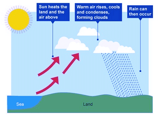
The air being heated becomes light and rises in convection currents. As it rises, it expands and loses heat and consequently, condensation takes place and cumulus clouds are formed. This process releases latent heat of condensation which further heats the air and forces the air to go further up.
Convectional precipitation is heavy but of short duration, highly localized, and is associated with a minimum amount of cloudiness. It occurs mainly during summer and is common over equatorial doldrums in the Congo Basin, the Amazon basin, and the islands of south-east Asia.
Orographic Rainfall
- When the saturated air mass comes across a mountain, it is forced to ascend and as it rises, it expands (because of a fall in pressure) and the temperature falls, and the moisture is condensed.
- This type of precipitation occurs when warm, humid airstrikes an orographic barrier (a mountain range) head-on. Due to the initial momentum, the air is forced to rise. As the moisture-laden air gains height, condensation sets in, and soon saturation point is reached. The surplus moisture falls as orographic rainfall along the windward slopes.
- The chief characteristic of this sort of rain is that the windward slopes receive greater rainfall. After giving rain on the windward side, when these winds reach the other slope, they descend, and their temperature goes up.

- Then their capacity to take in moisture increases and hence, these leeward slopes are left rainless and dry. The area situated on the leeward side, which gets less rainfall is known as the rain-shadow area (Some arid and semi-arid regions are a direct consequence of the rain-shadow effect. Example: Patagonian desert in Argentina, Eastern slopes of Western Ghats).
- It is also known as the relief rain, for example-Mahabaleshwar, situated on the Western Ghats, receives more than 600 cm of rainfall, whereas Pune, lying in the rain shadow area, receives only about 70 cm.
- The Wind descending on the Leeward Side is heated adiabatically and is called Katabatic Wind.
Frontal Rainfall
When two air masses with different temperatures meet, turbulent conditions are produced. Along the front convection takes place and causes precipitation. For instance, in northwest Europe, cold continental air and warm oceanic air converge to produce heavy rainfall in adjacent areas.
Cyclonic Rain
Cyclonic Rainfall is convectional rainfall on a large scale. The precipitation in a tropical cyclone is of conventional type while that in a temperate cyclone is because of frontal activity.
Monsoonal Rainfall
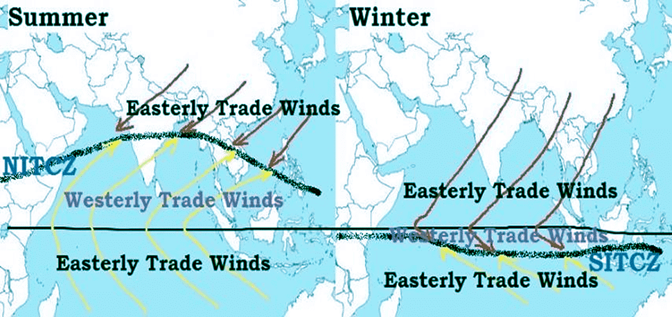
This form of precipitation is marked by the seasonal change in wind patterns, such as the southwest monsoon, which transport moisture from the ocean and result in substantial rainfall across South and Southeast Asia.

World Distribution of Rainfall
Precipitation levels vary across the Earth's surface and exhibit seasonal differences. Generally, as one moves away from the equator towards the poles, rainfall diminishes progressively.
- Coastal regions around the world experience higher rainfall compared to inland areas. This is primarily because oceans serve as substantial sources of moisture.
- Between latitudes 35° and 40° north and south of the equator, eastern coastlines receive more rainfall, which decreases towards the west. However, between 45° and 65° north and south of the equator, due to westerlies, rainfall is first encountered on the western edges of continents and decreases towards the east.
- When mountains run parallel to the coast, rainfall is greater on the coastal side facing the wind, and it diminishes on the leeward side.
- Based on the annual precipitation levels, major precipitation patterns in the world can be categorized as follows:
- Equatorial regions, windward slopes of mountains in the cool temperate zone along western coasts, and monsoon-influenced coastal areas receive heavy rainfall exceeding 200 cm per year.
- Continental interiors experience moderate rainfall ranging from 100 to 200 cm per year. Coastal regions of continents receive moderate rainfall as well.
- Central portions of tropical regions and eastern and inland sections of temperate regions receive rainfall between 50 and 100 cm per year.
- Areas in the rain shadow of inland regions and high latitudes receive very low rainfall, less than 50 cm per year.
- The seasonal distribution of rainfall is a crucial factor in assessing its impact. In certain areas, such as the equatorial belt and the western parts of cooler temperate regions, rainfall is evenly spread throughout the year.
|
191 videos|373 docs|118 tests
|
FAQs on Types & Distribution of Precipitation - Geography Optional for UPSC (Notes)
| 1. What are the types of precipitation? |  |
| 2. What are the types of rainfall? |  |
| 3. How is rainfall distributed around the world? |  |
| 4. What are the types and distribution of precipitation discussed in the article? |  |
| 5. What are some frequently asked questions about precipitation in the UPSC exam? |  |
|
191 videos|373 docs|118 tests
|

|
Explore Courses for UPSC exam
|

|


