Geography of North America- 2 | Famous Books for UPSC Exam (Summary & Tests) PDF Download

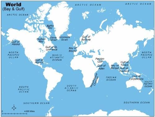
Gulfs Of North America
A gulf is a portion of the ocean that penetrates land which is very large in size, shape, and depth. They are generally larger and more deeply indented than bays and often make excellent harbors. Many important trading centers are located on gulfs.
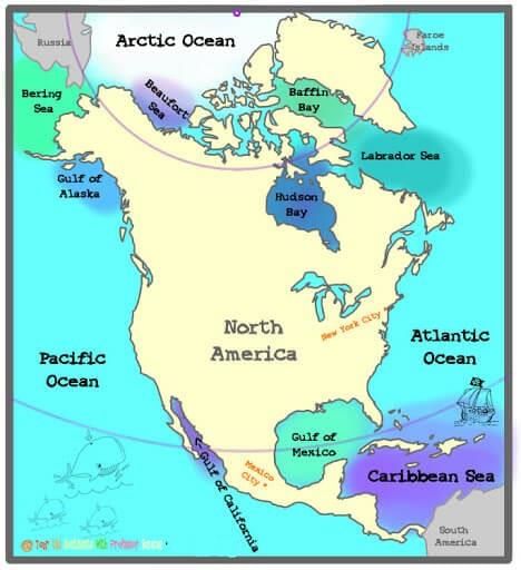
- Gulf of Mexico
- Gulf of Alaska
- Gulf of California
- Gulf of St. Lawrence
Gulf Of Mexico
It is an important economic site for three countries and surrounded by the United States, Mexico, and the island nation of Cuba. As one of the biggest gulf, it has a coastline of 5000 kilometers.
Gulf Of Alaska
It is situated in the northwestern part of North America where two types of water run into each other, a light, almost electric blue merging with a darker slate-blue.
Gulf Of California
It separates the Baja California Peninsula from the Mexican mainland. It has a coastline of 4000 km( 2600 miles). It is considered to be one of the most diversified seas on the planet and is home to more than 5,000 species of microinvertebrates.
Gulf Of St. Lawrence
It is a water outlet of the North American Great Lakes via Saint Lawrence river. It’s a semi-enclosed sea that covers 236,000 square kilometers (91,000 sq mi) and containing about 35,000 cubic kilometers (8,400 cu mi) of water, which results in an average depth of 148 meters (486 ft).
Islands
The world famous islands of North America are:
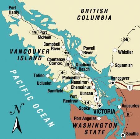
Vancouver Island
It is situated on Canada’s Pacific Coast, is known for its mild climate and thriving arts community. It is separated from British Columbia mainland by the Strait of Georgia and Queen Charlotte Strait and from Washington by the Juan De Fuca Strait.
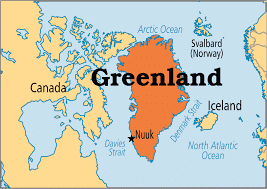
Greenland
It is a massive island situated between Atlantic and Arctic oceans and 80% of its land is covered by ice.
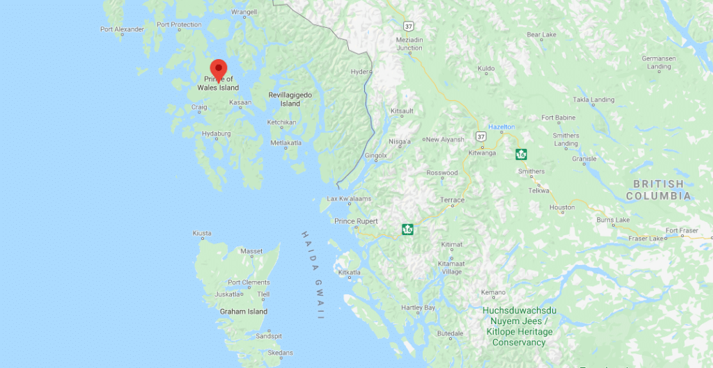
Prince Of Wales Island
It is one of the islands of the Alexander Archipelago in the Alaska Panhandle. This ranks four among the island in size.
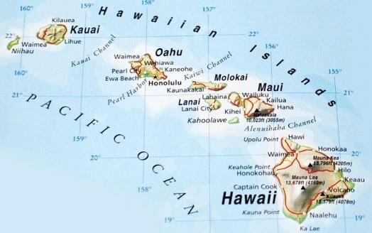
Hawaii Island
It is otherwise known as the Big Island provides a vast canvas of natural environment and it is the largest island of the Hawaiian archipelago in the Central Pacific.
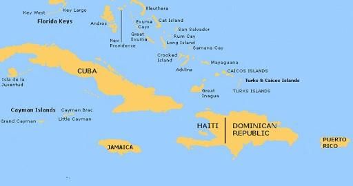
Cuba Islands Of Antilles
It is known as the sugar bowl of the World and its vast source of metallic resources include cobalt, nickel, iron ore, chromium, and copper. Other resources include timber, petroleum, silica, salt, and arable land.
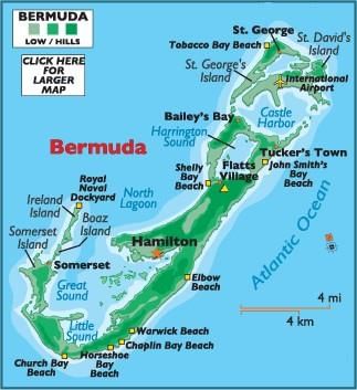
Bermuda Island
It is the territory of the British Islands in North Atlantic and famous for its pink sand beaches such as Elbow and Horseshoe Bay.
Drainage Pattern
There are many rivers in North America. River of North America can be grouped according to the seas they drain into, like
- Rivers draining into the Gulf of Mexico
- Rivers draining into the Atlantic Ocean
- Arctic Ocean drainage
- Pacific Ocean Drainage
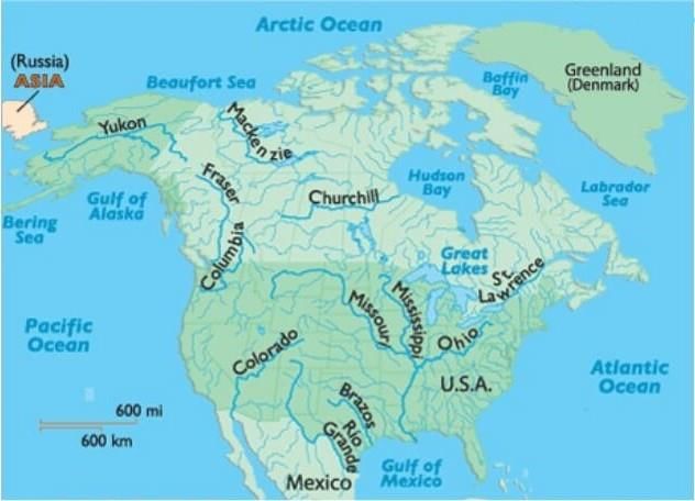
1. The Rivers Draining Into The Gulf Of Mexico
These are the Mississippi, Missouri and their tributaries drain the whole of the lower Central Lowlands. They start from the Western Cordilleras. The Ohino and Tennesse. Rivers which are also tributaries of the Mississippi but have their source in the Appalachians are exceptions.
2. Rivers draining into the Atlantic Ocean
River St. Lawrence is the large river of this group. In this group the smaller rivers of the Fall Line can also be included.
3. Arctic Ocean drainage
River Mackenzie which has many shallow lakes on the Canadian Shield. River Nelson flow into the Hudson Bay.
4. Pacific Ocean Drainage
River Yukon in Alaska, Columbia, Fraser, and Colorado along the west coast. The Colorado River cuts across the Colorado plateau and forms the world’s most famous and attractive deep gorges, known as grand canons having nearly one km depth. Among the other rivers, the Yukon, the Fraser, the Snake, the Humboldt, the Sacramento, the San Joaquin, etc. are well known.
Seas In North America
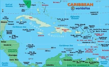
Caribbean Sea
It is a sub-oceanic basin bordered by coasts of Venezuela, Colombia, and Panama; to the west by Costa Rica, Nicaragua, Honduras, Guatemala, Belize, and the Yucatán Peninsula of Mexico; to the north
by the Greater Antilles islands of Cuba, Hispaniola, Jamaica, and Puerto Rico; and to the east by the north-south chain of the Lesser Antilles, consisting of the island arc that extends from the Virgin Islands in the northeast to Trinidad.
Beaufort Sea
It is situated in the north of Canada and Alaska is known to be the marginal sea of Arctic Ocean covering an area of 184,000 sq. miles and the average depth of 3,239 ft (1,004 m).
Hudson Bay
It is known as the second largest bay in the world which encompasses an area of 1,230,000 square kilometer (470,000mi) and large body of Salt water.
Labrador Sea
It is bordered by continental shelves and separates Canada from Green Land.
Bering Sea
It is situated on the extreme North of North America separating the continents of Asia and north America.
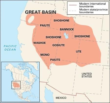
Inland Drainage System
The Great Basin area in the Rocky Mountains (Middle) has rivers which do not reach the coast, but terminate in the land. This is the Inland Drainage System.
The rivers are small, seasonal and end up in saline lakes.
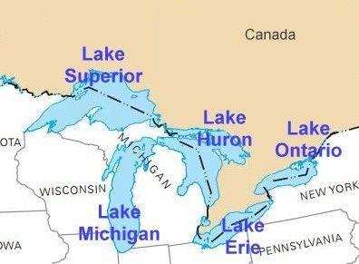
Lakes In North America
- The Lakes of the Canadian Shield are freshwater bodies.
- The Great Salt Lake between the Rockies and the Sierra Nevada has a high salt content and is an area of ‘Inland drainage’.
- Lake Erie in Ontario, Canada, and Michigan, New York, Ohio, Pennsylvania in the USA.
- Lake Huron in Ontario, Canada, and Michigan in the USA.
- Lake Ontario in Ontario, and New York in the USA.
- Lake St Clair in Ontario, and Michigan in the USA.
- Lake Superior in Michigan, Minnesota, Wisconsin in the USA.
|
745 videos|1444 docs|633 tests
|
FAQs on Geography of North America- 2 - Famous Books for UPSC Exam (Summary & Tests)
| 1. What countries are part of North America? |  |
| 2. What are the major physical features of North America? | |
| 3. What is the climate like in North America? | |
| 4. What are the main economic activities in North America? | |
| 5. Are there any significant natural hazards in North America? | |


Objective type Questions
,past year papers
,Geography of North America- 2 | Famous Books for UPSC Exam (Summary & Tests)
,video lectures
,practice quizzes
,shortcuts and tricks
,Viva Questions
,mock tests for examination
,Free
,MCQs
,Important questions
,Previous Year Questions with Solutions
,Exam
,Extra Questions
,Semester Notes
,study material
,Sample Paper
,Geography of North America- 2 | Famous Books for UPSC Exam (Summary & Tests)
,Summary
,ppt
,Geography of North America- 2 | Famous Books for UPSC Exam (Summary & Tests)
;


Geography of North America- 2 Free PDF Download
Importance of Geography of North America- 2
Geography of North America- 2 Notes
Geography of North America- 2 UPSC Questions
Study Geography of North America- 2 on the App
|
© EduRev
|
Education Revolution
|


|


