UPSC Exam > UPSC Notes > Geography for UPSC CSE > Formation & Division of Plains
Formation & Division of Plains | Geography for UPSC CSE PDF Download
| Table of contents |
|
| The Great North Indian Plain |
|
| Formation of the Indo-Gangetic–Brahmaputra Plain |
|
| Features of Indo – Gangetic – Brahmaputra Plain |
|
| Geomorphological Features |
|

The Great North Indian Plain
The Indo-Gangetic- Brahmputra Plain, also known as the Indus-Ganga Plain and the North Indian River Plain, is a 2.5-million km2 (630-million-acre) fertile plain encompassing northern regions of the Indian subcontinent, including most of northern and eastern India.
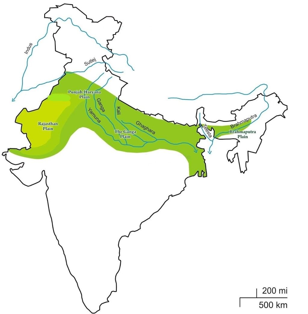
- It also encompasses the eastern parts of Pakistan, virtually all of Bangladesh, and the southern plains of Nepal
- The Great North Indian plains are a homogeneous surface with an invisible slope.
- These are alluvial fertile plains formed by the deposition process of the Himalayan Rivers.
- Along with the Himalayan Rivers, the Vindhyan Rivers are also having a prominent role in making the land fertile.
- It deposits a large number of sediments along the foothills. The sedimentary deposition makes this area fertile and the breadbasket of the country and it plays a crucial role in socio-economic-cultural spheres.
Formation of the Indo-Gangetic–Brahmaputra Plain
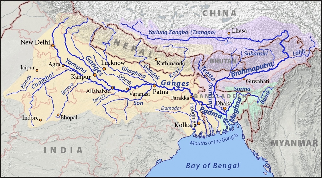
- These plains have been formed by the depositional works of the three major river systems – Indus, Ganga, and Brahmaputra. The sediments of these rivers filled the wide depression that existed between the Peninsular and Himalayan regions.
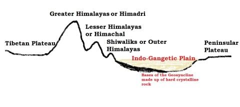
- The formation of the Indo-Gangetic plain is closely related to the formation of Himalayas.
Trough Formation
- The rivers which were previously flowing into Tethys sea (Before Indian Plate collided with Eurasian Plate – continental drift, plate tectonics) deposited huge amount of sediments in the Tethys Geosyncline. [Geosyncline – a massive depression]
- The Himalayas are formed out of these sediments, which were uplifted, folded, and compressed due to the northern Indian Plate movement.
- The northern movement of the Indian Plate also created a trough to the south of Himalayas.
Depositional Activity
- During the initial stages of upliftment of sediments, the already existing rivers changed their course several times, and they were rejuvenated each time (perpetual youth stage of rivers {Fluvial Landforms}).
- The rejuvenation is associated with intense headward and vertical downcutting of the soft strata overlying the harder rock stratum.
- Headward erosion and vertical erosion of the river valley in the initial stages, lateral erosion in later stages contributed a massive amount of conglomerates (detritus)(rock debris, silt, clay etc.) which were carried downslope.
- [Head ward erosion == Erosion at the origin of a stream channel, which causes the origin to move back away from the direction of the streamflow, and so causes the stream channel to lengthen]
- These conglomerates were deposited in the depression (Indo-Gangetic Trough or Indo-Gangetic syncline) (the base of the geosyncline is hard crystalline rock) between peninsular India and the convergent boundary (the region of present day Himalayas). Question for Formation & Division of PlainsTry yourself:A Geosyncline is aView Solution
New Rivers and more Alluvium
- The raising of the Himalayas and the subsequent formation of glaciers gave rise to many new rivers. These rivers, along with glacial erosion {Glacial Landforms}, supplied more alluvium which intensified the filling of the depression.
- With the accumulation of more and more sediments (conglomerates), the Tethys sea started receding.
- With the passage of time, the depression was filled with alluvium, gravel, rock debris (conglomerates) and the Tethys completely disappeared, leaving behind a monotonous aggradational plain
(i) monotonous = featureless topography
(ii) aggradational plain =plain formed due to depositional activity. - Indo-Gangetic plain is a monotonous aggradational plain formed due to fluvial depositions.
- Upper peninsular rivers have also contributed to the formation of plains, but a minimal extent.
- During recent times (since a few million years), depositional work of three major river systems viz., the Indus, the Ganga, and the Brahmaputra have become predominant.
- Hence this arcuate (curved) plain is also known as Indo-Gangetic-Brahmaputra Plain.
Features of Indo – Gangetic – Brahmaputra Plain
- Indo-Gangetic-Brahmaputra Plain is the largest alluvial tract of the world.
- It stretches for about 3,200 km from the mouth of the Indus to the mouth of the Ganga. Indian sector of the plain accounts for 2,400 km.
- The Shiwaliks well marks the northern boundary, and the southern boundary is a wavy irregular line along the north edge of Peninsular India.
- Sulaiman and Kirthar ranges mark the western border. On the eastern side, the plains are bordered by Purvanchal hills.
- The width of the plain varies from region to region. It is widest in the west where it stretches for about 500 km. Its width decreases in the east.
- The thickness of the alluvium deposits also varies from place to place. The maximum depth of the alluvium up to the basement rocks is about 6,100 m (not uniform and varies significantly from place to place).
- The cones or alluvial fans of Kosi in the north and those of Son in the south exhibit greater alluvial thickness while the intra-cone areas have relatively shallower deposits.
- Extreme horizontality of this monotonous plain is its chief characteristic.
- Its average elevation is about 200 m above mean sea level. The highest peak is 291 m above indicate sea level near Ambala (This elevation forms the drainage divide or watershedbetween the Indus system and Ganga system).
- Its average gradient from Saharanpur to Kolkata is only 20 cm per km, and it decreases to 15 cm per km from Varanasi to the Ganga delta.
Question for Formation & Division of PlainsTry yourself:Eastern Side of the Indo - Gangetic- Brahmaputra plain is bordered by
View Solution
Geomorphological Features
The Great North Indian plain is divided into the following subdivisions based on relief features:
- The Bhabar Plains
- The Terai Tract
- The Bhangar
- The Khadar
- Reh or Kollar
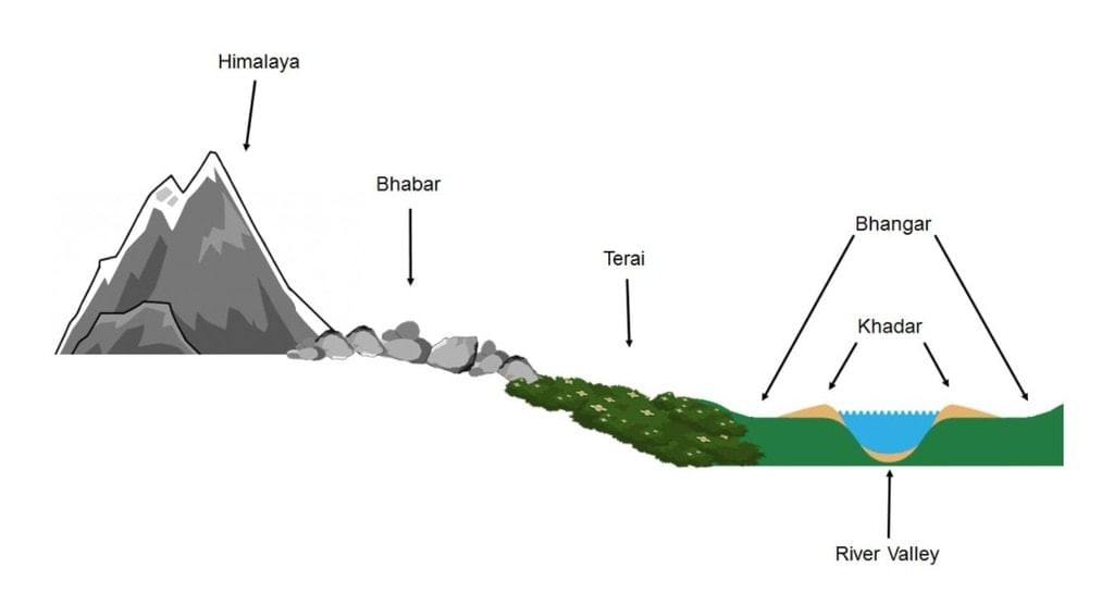
1. The Bhabar Plains
- It is a narrow, porous, northernmost stretch of Indo-Gangetic plain.
- It is about 8-16 km wide running in an east-west direction along the foothills (alluvial fans) of the Shivalik.
- They show a remarkable continuity from the Indus to the Tista.
- Rivers descending from the Himalayas deposit their load along the foothills in the form of alluvial fans.
- These alluvial fans have merged to build up the bhabar belt.
- The porosity of bhabar is a unique feature.
- The porosity is due to the deposition of many pebbles and rock debris across the alluvial fans.
- The streams disappear once they reach the bhabar region because of this porosity.
- Therefore, the area is marked by dry river courses except in the rainy season.
- The Bhabar belt is comparatively narrow in the east and extensive in the western and north-western hilly regions.
- The area is not suitable for agriculture, and only big trees with large roots thrive in this belt.
2. The Terai Tract
- Terai is an ill-drained, damp (marshy)and thickly forestednarrow tract to the south of Bhabar running parallel to it.
- The Terai is about15-30 km wide.
- The underground streams of the Bhabar belt re-emerge in this belt.
- This thickly forested region provides shelter to a variety of wildlife. [Jim Corbett National Park in Uttarakhand and Kaziranga National Park in Assam lie in Terai region]
- The Terai is more marked in the eastern part than in the west because the eastern parts receive a comparatively higher amount of rainfall.
- Most of the Terai land, especially in Punjab, Uttar Pradesh and Uttarakhand, has been turned into agricultural land that gives good sugarcane, rice, and wheat crops.
3. The Bhangar
- The Bhangar is the older alluvium along the river beds forming terraces higher than the flood plain.
- The terraces are often impregnated with calcareous concretions known as ‘KANKAR’.
- ‘The Barind plains’ in the deltaic region of Bengal and the ‘bhur formations’ in the middle Ganga and Yamuna doab are regional variations of Bhangar.
- Bhur denotes an elevated piece of land situated along the Ganga river banks, especially in the upper Ganga-Yamuna Doab. This has been formed due to the accumulation of wind-blown sands during the hot, dry months of the year.
- Bhangar contains fossils of animals like rhinoceros, hippopotamus, elephants, etc.
4. The Khadar
- The Khadar is composed of newer alluvium and forms the flood plains along the river banks.
- A new layer of alluvium is deposited by river floods almost every year.
- This makes them the most fertile soils of the Ganges.
5. Reh or Kollar
- Reh or Kollar comprises saline efflorescences of drier areas in Haryana.
- Reh areas have spread in recent times with an increase in irrigation (capillary action brings salts to the surface).
The document Formation & Division of Plains | Geography for UPSC CSE is a part of the UPSC Course Geography for UPSC CSE.
All you need of UPSC at this link: UPSC
|
264 videos|875 docs|232 tests
|
FAQs on Formation & Division of Plains - Geography for UPSC CSE
| 1. What are the major geological processes involved in the formation of the Indo-Gangetic-Brahmaputra Plain? |  |
Ans. The Indo-Gangetic-Brahmaputra Plain was primarily formed through the sedimentation processes that occurred as a result of the erosion of the Himalayan mountain range. The rivers originating from the Himalayas, such as the Ganges, Yamuna, and Brahmaputra, carried sediments down to the plains, depositing them over millions of years. Additionally, tectonic activities contributed to the uplifting of the Himalayas, which further influenced the landscape of the plains.
| 2. What are the key geomorphological features of the Indo-Gangetic-Brahmaputra Plain? | |
Ans. The Indo-Gangetic-Brahmaputra Plain is characterized by its vast, flat expanse with several distinct geomorphological features including alluvial plains, river valleys, and floodplains. The region is also marked by the presence of river terraces, oxbow lakes, and periodic flood zones. The plain is divided into different sections based on the variations in topography and sediment deposition.
| 3. How is the Indo-Gangetic-Brahmaputra Plain divided in terms of its geographical features? | |
Ans. The Indo-Gangetic-Brahmaputra Plain can be divided into several regions based on elevation and river systems. These include the Punjab Plain, the Haryana Plain, the Ganges Plain, and the Brahmaputra Valley. Each of these sections has unique characteristics in terms of soil types, vegetation, and agricultural practices, largely influenced by the river systems that flow through them.
| 4. What is the significance of the Indo-Gangetic-Brahmaputra Plain for agriculture and settlement? | |
Ans. The Indo-Gangetic-Brahmaputra Plain is one of the most fertile regions in India, making it a significant area for agriculture. The alluvial soil enriched by river sediments is ideal for growing a variety of crops, including rice, wheat, and sugarcane. Additionally, the plain's flat terrain and abundant water supply support dense human settlement and agricultural development, contributing significantly to the economy of the region.
| 5. What environmental challenges does the Indo-Gangetic-Brahmaputra Plain face today? | |
Ans. The Indo-Gangetic-Brahmaputra Plain faces several environmental challenges, including flooding, soil erosion, and water pollution. Flooding is a recurring issue during the monsoon season, which can lead to loss of crops and displacement of communities. Additionally, urbanization and industrial activities have contributed to the pollution of rivers, affecting the water quality and biodiversity in the region. Sustainable management practices are essential to address these challenges.
About this Document

8.7K Views

4.74/5
Rating

Sep 20, 2025
Last updated
Related Exams
Document Description: Formation & Division of Plains for UPSC 2025 is part of Geography for UPSC CSE preparation.
The notes and questions for Formation & Division of Plains have been prepared according to the UPSC exam syllabus. Information about Formation & Division of Plains covers topics
like The Great North Indian Plain, Formation of the Indo-Gangetic–Brahmaputra Plain, Features of Indo – Gangetic – Brahmaputra Plain, Geomorphological Features and Formation & Division of Plains Example, for UPSC 2025 Exam. Find important definitions, questions, notes, meanings, examples, exercises and tests below for Formation & Division of Plains.
Introduction of Formation & Division of Plains in English is available as part of our Geography for UPSC CSE
for UPSC & Formation & Division of Plains in Hindi for Geography for UPSC CSE course.
Download more important topics related with notes, lectures and mock test series for UPSC
Exam by signing up for free. UPSC: Formation & Division of Plains | Geography for UPSC CSE
Description
Full syllabus notes, lecture & questions for Formation & Division of Plains | Geography for UPSC CSE - UPSC | Plus excerises question with solution to help you revise complete syllabus for Geography for UPSC CSE | Best notes, free PDF download
Information about Formation & Division of Plains
In this doc you can find the meaning of Formation & Division of Plains defined & explained in the simplest way possible. Besides explaining types of
Formation & Division of Plains theory, EduRev gives you an ample number of questions to practice Formation & Division of Plains tests, examples and also practice UPSC
tests

Related Searches
Formation & Division of Plains | Geography for UPSC CSE
,ppt
,Semester Notes
,past year papers
,Viva Questions
,MCQs
,Important questions
,Sample Paper
,video lectures
,Extra Questions
,Formation & Division of Plains | Geography for UPSC CSE
,Formation & Division of Plains | Geography for UPSC CSE
,mock tests for examination
,shortcuts and tricks
,Previous Year Questions with Solutions
,Exam
,Free
,Summary
,practice quizzes
,Objective type Questions
,study material
;


Additional Information about Formation & Division of Plains for UPSC Preparation
Formation & Division of Plains Free PDF Download
The Formation & Division of Plains is an invaluable resource that delves deep into the core of the UPSC exam.
These study notes are curated by experts and cover all the essential topics and concepts, making your preparation more efficient and effective.
With the help of these notes, you can grasp complex subjects quickly, revise important points easily,
and reinforce your understanding of key concepts. The study notes are presented in a concise and easy-to-understand manner,
allowing you to optimize your learning process. Whether you're looking for best-recommended books, sample papers, study material,
or toppers' notes, this PDF has got you covered. Download the Formation & Division of Plains now and kickstart your journey towards success in the UPSC exam.
Importance of Formation & Division of Plains
The importance of Formation & Division of Plains cannot be overstated, especially for UPSC aspirants.
This document holds the key to success in the UPSC exam.
It offers a detailed understanding of the concept, providing invaluable insights into the topic.
By knowing the concepts well in advance, students can plan their preparation effectively.
Utilize this indispensable guide for a well-rounded preparation and achieve your desired results.
Formation & Division of Plains Notes
Formation & Division of Plains Notes offer in-depth insights into the specific topic to help you master it with ease.
This comprehensive document covers all aspects related to Formation & Division of Plains.
It includes detailed information about the exam syllabus, recommended books, and study materials for a well-rounded preparation.
Practice papers and question papers enable you to assess your progress effectively.
Additionally, the paper analysis provides valuable tips for tackling the exam strategically.
Access to Toppers' notes gives you an edge in understanding complex concepts.
Whether you're a beginner or aiming for advanced proficiency, Formation & Division of Plains Notes on EduRev are your ultimate resource for success.
Formation & Division of Plains UPSC Questions
The "Formation & Division of Plains UPSC Questions" guide is a valuable resource for all aspiring students preparing for the
UPSC exam. It focuses on providing a wide range of practice questions to help students gauge
their understanding of the exam topics. These questions cover the entire syllabus, ensuring comprehensive preparation.
The guide includes previous years' question papers for students to familiarize themselves with the exam's format and difficulty level.
Additionally, it offers subject-specific question banks, allowing students to focus on weak areas and improve their performance.
Study Formation & Division of Plains on the App
Students of UPSC can study Formation & Division of Plains alongwith tests & analysis from the EduRev app,
which will help them while preparing for their exam. Apart from the Formation & Division of Plains,
students can also utilize the EduRev App for other study materials such as previous year question papers, syllabus, important questions, etc.
The EduRev App will make your learning easier as you can access it from anywhere you want.
The content of Formation & Division of Plains is prepared as per the latest UPSC syllabus.
|
© EduRev
|
Education Revolution
|


|


Signup to see your scores
go up
within 7 days!
within 7 days!
Takes less than 10 seconds to signup