Ocean Current and types of Currents | Geography for UPSC CSE PDF Download
| Table of contents |
|
| Ocean Currents |
|
| Types of Ocean Currents |
|
| Forces Responsible For Ocean Currents |
|
| Important ocean currents |
|
| Causes of Ocean Currents |
|
| Desert Formation and Ocean Currents |
|

Ocean Currents
Ocean current is a continuous general movement of Ocean Water in a specific direction. As an analogy, you can perceive it as a river flowing over the ocean surface. About 10% of the water in the World’s Ocean is involved in the Surface Currents.
Most surface currents move water in the horizontal and vertical direction in the top layer above the thermocline (The layer where temperature changes steeply). The water beneath the thermocline also circulates, but the movement is very slow.
If you remember, the heat budget was different in the latitudes with heat surplus in the tropics and heat deficit in the arctic region (Beyond 40 degrees N and S).
All the weather phenomenon and circulatory phenomenon transfer heat from the tropics towards the pole and maintain the heat balance. The ocean currents follow the same phenomenon.
Ocean currents are categorized as warm ocean currents and cold ocean currents.
It would be best to keep this in mind that warm and cold are not because of their absolute temperature. It is because of their impact on the destination region.
A current that moves towards the pole in both the hemispheres is a warm current because it carries warm water from lower latitudes to the upper latitudes.
On the contrary, a current coming from the upper latitudes towards the tropics is a cold current.
Types of Ocean Currents
➤ Based on depth
- The ocean currents may be classified based on their depth as surface currents and deep water currents:
- surface currents constitute about 10 percent of all the water in the ocean, and these waters are the upper 400 m of the ocean;
- deep water currents make up the other 90 percent of the ocean water. These waters move around the ocean basins due to variations in density and gravity.
(i) The density difference is a function of different temperatures and salinity
(ii) These deep waters sink into the deep ocean basins at high latitudes where the temperatures are cold enough to cause the density.
- Deep waters sink into the deep ocean basins at high latitudes, where the temperatures are cold enough to cause the density to increase.Question for Ocean Current and types of CurrentsTry yourself:Which one of the following ocean currents is different from others?View Solution
➤ Based on temperature
- Ocean currents are classified based on temperature: as cold currents and warm currents:
- Cold currents bring cold water into warm water areas [from high latitudes to low latitudes]. These currents are usually found on the west coast of the continents (currents flow in the clockwise direction in the northern hemisphere and anti-clockwise direction in the southern hemisphere) in the low and middle latitudes (true in both hemispheres) and on the east coast in the higher latitudes in the Northern Hemisphere;
- Warm currents bring warm water into cold water areas[low to high latitudes] and are usually observed on the east coast of continents in the low and middle latitudes (true in both hemispheres). In the northern hemisphere, they are found on the west coasts of continents in high latitudes.
Forces Responsible For Ocean Currents
Primary Forces
➤ Influence of insolation
- Heating by solar energy causes the water to expand. That is why near the equator, the ocean water is about 8 cm higher in level than in the middle latitudes.
- This causes a very slight gradient, and water tends to flow down the slope. The flow is normally from east to west.
➤ Influence of wind (atmospheric circulation)
- Wind blowing on the surface of the ocean pushes the water to move. Friction between the wind and the water surface affects the movement of the water body in its course.
- Winds are responsible for both magnitude and direction [Coriolis force also affects direction] of the ocean currents. Example: Monsoon winds are responsible for the seasonal reversal of ocean currents in the Indian ocean.
- The oceanic circulation pattern roughly corresponds to the earth’s atmospheric circulation pattern.
- The air circulation over the oceans in the middle latitudes is mainly anticyclonic [Sub-tropical High-Pressure Belt] (more pronounced in the southern hemisphere than in the northern hemisphere due to differences in the extent of landmass). The oceanic circulation pattern also corresponds to the same.
- The oceanic circulation follows this pattern at higher latitudes, where the wind flow is mostly cyclonic [Sub-polar Low-Pressure Belt].
- In regions of pronounced monsoonal flow [Northern Indian Ocean], the monsoon winds influence the current movements which change directions according to seasons.
➤ Influence of gravity
- Gravity tends to pull the water down to pile and create gradient variation.
➤ Influence of Coriolis force
- The Coriolis force intervenes and causes the water to move to the right in the northern hemisphere and to the southern hemisphere.
- These large accumulations of water and the flow around them are called Gyres. These produce large circular currents in all the ocean basins. One such circular current is the Sargasso Sea.
Secondary Forces
- Temperature differences and salinity differences are secondary forces.
- Differences in water density affect the vertical mobility of ocean currents (vertical currents).
- Water with high salinity is denser than water with low salinity, and in the same way, cold water is denser than warm water.
- Denser water tends to sink, while relatively lighter water tends to rise.
- Cold-water ocean currents occur when the cold water at the poles sinks and slowly moves towards the equator.
- Warm-water currents travel out from the equator along the surface, flowing towards the poles to replace the sinking cold water.
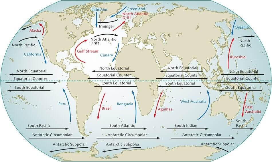
Important ocean currents
You need to remember cold and warm ocean currents.
Causes of Ocean Currents
➤ Planetary Winds
Planetary winds play a vital role in the formation and sustenance of ocean currents. Since planetary winds blow with consistency, over the ocean's surface, they tend to push the water in one direction because of friction. This is the main cause of the flow of water.
Because of the Coriolis Effect, in the Northern Hemisphere currents flow to the wind direction right while in the Southern Hemisphere, winds blow to the left.
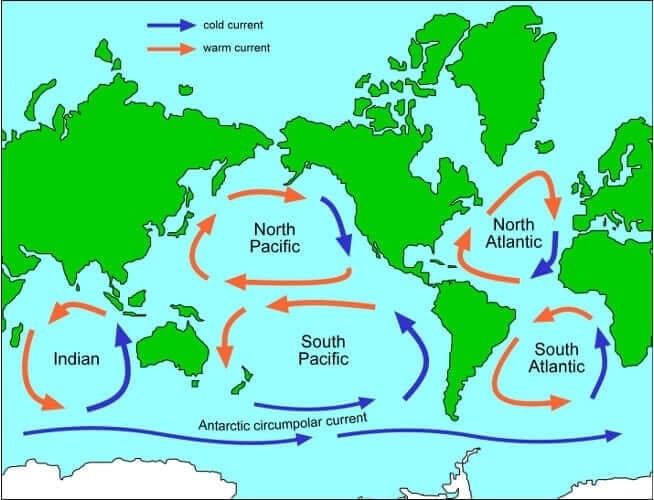
Intervening continents and basin topography often block the water's continuous flow and often deflect the moving water in a circular pattern.
This circular motion of water along the periphery of the ocean basin is called Gyre. The following Map will broadly show the formation of different gyres in Oceans.
Effect of the temperature
- There are marked variations in the horizontal and vertical distribution of the temperatures in the ocean.
- In general, the temperature decreases as we move towards the pole from the equator.
- There is an inverse relationship between temperature and density of the water, i.e. higher the temperature, the lower its density. As a result, the warm and low-density water from the equatorial region moves towards the colder polar waters.
- Contrary to this, there is a movement of ocean water below the water surface in subsurface current from colder polar areas to warmer equatorial area. The Gulf Stream and Kuroshio Current (warm) are excellent examples of this.
➤ Salinity
- The salinity of the Ocean varies from place to place. Water with high salinity is denser than the one with low salinity.
- Ocean currents on the water surface are generated from low salinity areas to the areas of high salinity.
- For example, ocean currents are moving from the ocean to inland seas, i.e. ocean current flows from the Atlantic to the Mediterranean Sea.
- A similar ocean current is seen from the Indian Ocean to the Red Sea via Bab Al Mandab. Peru Current also originates because of the difference in density.
Rotation of Earth
- The rotation of the earth from west to east on its axis is the cause of a deflective force called Coriolis force.
- Like winds, it deflects the ocean current in the Northern Hemisphere towards its right and the Southern Hemisphere.
- Because of this, ocean currents form a clockwise circulation in the Northern Hemisphere and Counterclockwise circulation in the Southern Hemisphere at the periphery of the ocean. This giant loop is called Gyre.
- A gyre formed in Northern Atlantic is of special importance as it traps the ocean's inner water and makes it stagnant.
- This stagnant body of water is known as the Sargasso sea named after the Sargassum weed found in it.
- Sargassum is unique vegetation endemic to it and is an internationally protected area. The Sargasso Sea is the only sea totally inside an ocean.Question for Ocean Current and types of CurrentsTry yourself:Which of the following factors influence ocean currents?
1. Rotation of the Earth
2. Air pressure and wind
3. Ocean water density
4. Revolution of the Earth
Select the correct answer using the codes given below
View Solution
Configuration of the coastline
Coastline plays an important role in governing the direction of the flow of the ocean current. For example, the equatorial current after being obstructed by the Brazilian coast is bifurcated into two branches. The Northern Branch is called the Caribbean current while the Southern branch is called the Brazilian current.
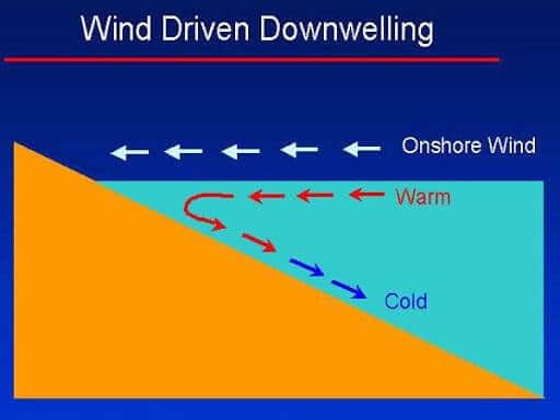
Note: After hitting a coastline, apart from moving towards North and South, some of the water also moves downward, this is called Downwelling. This water penetrates deep in the ocean and moves parallel to the surface current as an undercurrent and comes out on the other side of the ocean as upwelling. Since this upwelling water comes out from the depth, it is relatively cold and brings a lot of nutrients to the surface. Regions, where upwelling is present, are rich fishing grounds Example: Peru coast.
Desert Formation and Ocean Currents
Major hot deserts are located between 20-30 degree latitudes and on the continents' western side. Why?
- The aridity of the hot deserts is mainly due to the effects of off-shore Trade Winds. Hence they are also called Trade Wind Deserts.
- The world's major hot deserts are located on the western coasts of continents between latitudes 15° and 30°N. And S (Question asked in Previous Mains Exam).
- They include the biggest Sahara Desert (3.5 million square miles). The next biggest desert is the Great Australian Desert. The other hot deserts are the Arabian Desert, Iranian Desert, Thar Desert, Kalahari and Namib Deserts.
- The hot deserts lie along the Horse Latitudes or the Sub-Tropical High-Pressure Belts where the air is descending, a condition least favourable for precipitation of any kind to take place.
- The rain-bearing Trade Winds blow off-shore and the Westerlies that are on-shore blow outside the desert limits.
- Whatever winds reach the deserts blow from cooler to warmer regions, and their relative humidity is lowered, making condensation almost impossible.
- There is scarcely any cloud in the continuous blue sky. The relative humidity is extremely low, decreasing from 60 per cent in coastal districts to less than 30 per cent in the desert interiors. Under such conditions, every bit of moisture is evaporated and the deserts are thus regions of permanent drought. Precipitation is both scarce and most unreliable.
- On the western coasts, cold currents give rise to mists and fogs by chilling the on-coming air. This air is later warmed by contact with the hot land, and little rainfalls.
- The cold Peruvian current's desiccating effect along the Chilean coast is so pronounced that the mean annual rainfall for the Atacama Desert is not more than 1.3 cm.
Atlantification
- Streams of warmer water from the Atlantic Ocean flow into the Arctic at the Barents Sea.
- This warmer, saltier Atlantic water is usually fairly deep under the more buoyant Arctic water at the surface.
- Lately, however, the Atlantic water has been creeping up. That heat in the Atlantic water helps keep ice from forming and melting existing sea ice from below.
- This process is called “Atlantification”.
- The ice is now getting hit both from the top by a warming atmosphere and at the bottom by a warming ocean.
|
175 videos|619 docs|192 tests
|
FAQs on Ocean Current and types of Currents - Geography for UPSC CSE
| 1. What are ocean currents? |  |
| 2. What are the different types of ocean currents? | |
| 3. What forces are responsible for ocean currents? | |
| 4. What are some important ocean currents? | |
| 5. What causes ocean currents? | |


Semester Notes
,video lectures
,Free
,practice quizzes
,shortcuts and tricks
,Extra Questions
,Ocean Current and types of Currents | Geography for UPSC CSE
,Summary
,mock tests for examination
,Viva Questions
,Objective type Questions
,Ocean Current and types of Currents | Geography for UPSC CSE
,study material
,Exam
,Important questions
,Previous Year Questions with Solutions
,past year papers
,Sample Paper
,ppt
,MCQs
,Ocean Current and types of Currents | Geography for UPSC CSE
;


Ocean Current and types of Currents Free PDF Download
Importance of Ocean Current and types of Currents
Ocean Current and types of Currents Notes
Ocean Current and types of Currents UPSC Questions
Study Ocean Current and types of Currents on the App
|
© EduRev
|
Education Revolution
|


|


