Types, Patterns and Morphology of Rural Settlements | Geography Optional for UPSC PDF Download
Introduction to Settlement Geography
- In geography, archaeology, and statistics, a populated place or settlement refers to a community where people reside. Settlements can vary in size, from a small group of houses to large cities with extensive urbanized areas. These communities can consist of hamlets, villages, towns, and cities.
- A settlement reflects the socioeconomic conditions and environmental limitations of a given area, encompassing both physical structures like houses and the people who live there. It represents the social, historical, cultural, and religious aspects of human life within a specific geographic environment.
- The development of settlements can be traced back to nomadic herders who eventually settled in one place due to the growth of families and the need for a stable living environment. As a result, villages began to form, often centered around agricultural activities.
- Over time, some villages accumulated non-agricultural surpluses, leading to the development of 'Mandis,' or marketplaces. Transportation routes connected these Mandis, giving rise to urban settlements. Consequently, settlements have evolved through various stages of human history, reflecting the diverse social and geographical factors that influence their formation.

Rural settlement vs Urban settlement
There are five key criteria that distinguish rural settlements from urban settlements:
- Morphology (physical structure): Urban settlements are characterized by tall buildings, broad roads, administrative centers, and recreational spaces, while rural settlements primarily consist of agricultural landscapes.
- Function (Primary, Secondary, Tertiary): The majority of the population in rural areas are engaged in primary activities, such as agriculture, while people in urban areas typically have jobs in secondary (manufacturing) and tertiary (service) sectors.
- Demography (population density): Urban settlements have high population densities and compact living spaces, whereas rural areas have lower population densities and more scattered settlements.
- Cultural traits: Urban areas often exhibit social class stratification, while rural areas tend to have more prominent caste and religious stratification.
- Infrastructure: Urban and rural areas differ in both economic and social infrastructure.
- Economic infrastructure: This includes transportation and communication systems, which are generally more developed in urban areas compared to rural areas.
- Social infrastructure: Urban areas typically have better access to health care, education, and recreational facilities compared to rural areas.
Census of India gives definitions of rural and urban areas based on three criteria:
- Rural Settlement
- Population is less than 5000
- Population density is less than 400 persons/Sq. km.
- More than 75 % of people are engaged in Agricultural and associated primary activities
- Run by Gram-Panchayats.
- Urban Settlement
- Population is greater than 5000
- Population density is greater than 400 persons/Sq. km. or 1000 persons/Sq. Mile
- More than 75 % of people are engaged in Non-Agricultural activities
- Run by Municipality, Cantonment Board, Corporation, etc.
Rural Settlement
- A rural settlement is a community where the majority of residents are involved in primary activities such as agriculture, forestry, mining, or fishing. These settlements consist of disorganized clusters of closely connected houses with poor ventilation and inadequate sewage and drainage systems. The roads in these settlements are often winding and not well-planned, sometimes ending abruptly at houses.
- Rural settlements not only encompass villages but also the surrounding agricultural fields, forestry areas, and livestock-raising lands that are functionally integrated with the village. These communities are characterized by strong social bonds and a high degree of cohesion among residents, reflecting a powerful centripetal force due to the close relationships between people.
- Both the physical layout and the social structure of rural settlements contribute to their overall makeup. They are made up of the village itself, along with agricultural land, forestry, and livestock-raising areas. These settlements are a reflection of the socio-economic aspirations of the people, their adaptability, the historical development of a living civilization, and their economic functionality.
In summary, a rural settlement is a community primarily focused on primary activities such as agriculture and resource extraction. These settlements are characterized by their disorganized layout, strong social ties, and integration of the village with surrounding agricultural and resource-based areas. Rural settlements represent the aspirations, adaptability, and history of the people who live there, as well as their economic functionality.
Hamlet
- A hamlet is a small human settlement.
- In British geography, a hamlet is considered smaller than a village and distinctly without a church.
- Officially, a hamlet differs from a village in having no commercial premises, but has residences and may have community buildings such as churches and public halls.
Village
- A village is a clustered human settlement or community, larger than a hamlet but smaller than a town, with a population ranging from a few hundred to a few thousand.
- In the past, villages were a usual form of community for societies that practice subsistence agriculture, and also for some non-agricultural societies.
- According to the 2011 census of India, 68.84% of Indians (around 833.1 million people) live in 640,867 different villages.
Rurban
- Rural + Urban
- Transitional Phase in between Rural and Urban settlements
- Run by Gram Panchayets
- Population is more than 5000 but less than 10,000.
Town
- A town is a medium-sized human settlement. Towns are generally larger than villages but smaller than cities, though the criteria which constitute them vary considerably in different parts of the world.
- Large town – 20,000 to 1 lakh people
- Town – 5,000 to 20,000 people.
- Census towns are defined as places that satisfy the following criteria:
- Minimum population of 5,000
- At least 75% of male working population engaged in non-agricultural pursuits
- Density of population at least 400/km2. (1,000 per sq. mile).
City
- A city is a large human settlement. Cities generally have extensive systems for housing, transportation, sanitation, utilities, land use, and communication. Their density facilitates interaction between people, government organizations, and businesses, sometimes benefiting different parties in the process.
- City – 1 lakh to 3 lakh Population
- Large City – 3 lakh to 1 million population.
Metropolis
- A metropolis is a large city or conurbation which is a significant economic, political, and cultural center for a country or region, and an important hub for regional or international connections, commerce, and communications. The term is Ancient Greek and means the “mother city” of a colony (in the ancient sense), that is, the city that sent out settlers.
- Minimum Population – 1 to 3 million.
- Conurbation – 3 to 10 million people.
Megalopolis
- The term was used by Patrick Geddes in his 1915 book Cities in Evolution. Jean Gottmann popularised this term in 1961.
- A megalopolis (sometimes called a megapolis; also megaregion, or supercity) is typically defined as a chain of roughly adjacent metropolitan areas, which may be somewhat separated or may merge into a
- continuous urban region.
- Megalopolis is derived from Greek:(mégas) meaning ‘great’ and (pólis) meaning ‘city’, therefore literally a ‘great city’. This term is closer in meaning to megacity.
- A megalopolis, also known as a mega-region, is a clustered network of cities.
- Gottmann defined its population as 25 million.
- Doxiadis defined a small megalopolis a similar cluster with a population of about 10 million.
Primate City
- A primate city (Latin: “prime, first rank”) is the largest city in its country or region, disproportionately larger than any others in the urban hierarchy.
- First proposed by the geographer Mark Jefferson in 1939.
- He defines a primate city as being “at least twice as large as the next largest city and more than twice as significant.”
- Among the best known examples of primate cities are London and Paris.
- Other major primate cities include Athens, Baghdad, Bangkok, Budapest, Buenos Aires, Cairo, Dublin, Jakarta, Kuala Lumpur, Lima, Mexico City, Seoul, Tehran, and Vienna.
Morphology of Rural Settlement
- Morphology refers to the internal structure or the constructional plan of a village which includes the layout of streets and roads, arrangement of houses, pattern of housing, geometrical size and shape of village and agricultural fields, location of either the water body, religious site, or the house of the village headman.
- Rural Morphology includes
- Physical Morphology
- Social Morphology
Physical Morphology
- Physical Morphology includes the study of the relationship between the following:
- Road to lane relationship: It includes how roads are connected to lanes.
- Lane to lane relationship:
- It is description of geometrical arrangement of lanes. How they are connected to each other and ending at what points.
- In Indian villages, lanes are extremely narrow meandering and ending abruptly. This shows unplanned character of Indian villages.
- In UK, cruciform villages have all the lanes cutting across 90 degree, because they are planned villages.
- Lane to house relationship:
- Geometry of lanes determines the arrangement of houses because houses grow along lanes.
- In India, lanes are largely unplanned and arrangement of houses determines the lane type.
- House to house relationship:
- Physical morphology is also determined by the spacing between the houses.
- In clustered villages, houses are unevenly spaced or they have wall to wall arrangement.
- Houses are hardly according to geometrical plan and their average height is variable.
- There is clustering of houses based on social structure/cast system.
- Role of geometrical shape of the agriculture field also determines the village pattern.
- House type can range from ‘Pucca’ to ‘Kutcha’ and in older parts of villages, ventilation is closed to the roof (depends on whether village is developed or not).
Social Morphology
- It refers to the social structure of a village which is based on cast, or class.
- In Indian villages, caste hierarchy is reflected in the morphology of villages.
- Social factors like division of work, untouchability (not so prominent now), social prohibition over the work of women and lower casts had all led to a distinct social morphology of Rural Settlements from urban ones.
- The following factors affect the following morphological character of villages:
- Arrangement of buildings
- Pattern of streets and fields
- Functional characteristics of settlement.
- For example, the houses of higher cast people like Brahmins and Rajputs would be large and people from the lower cast would have huts, kutcha houses with cattle.
- The intermediate regions of rural settlement comprise of the people of service casts like Ahirs, Jats, Loth, etc.
- Cast based hamlets at times emerge. These are closely linked with centre under the Jajmani system (inter cast cooperation like higher cast people requiring lower cast people for some specific work like ironsmith) and act like a unit.
- K. N. Singh in his religious ritual and secular dominance model highlighted the importance of two concepts:
- Development of twin settlement which included:
- Caste Hindus
- Outcasts
- The segregation was much pronounced during the past favouring the outgrowth of the helmeted structure of villages, In the case of compact settlements out-castes generally lived on the outer parts of the built-up area in a direction (south, south-east, and north, etc.) less conducive for wind movement, for even air gets polluted after coming in contact with a Shudra‘s body.
- How and why these traditions came into being is a matter of debate amongst scholars, but the author believes these untouchables to be the remnant of the pre-Aryan tribes who were always despised by the Aryans and later Rajput settlers.
- Secular dominance model: Under this model, all caste and religion came together as functional units under the old Jajmani system. For example, landowners required the services of landless people for the cultivation of fields.
Thus, the socio-cultural traits of rural settlement is also a field of study in the settlement system
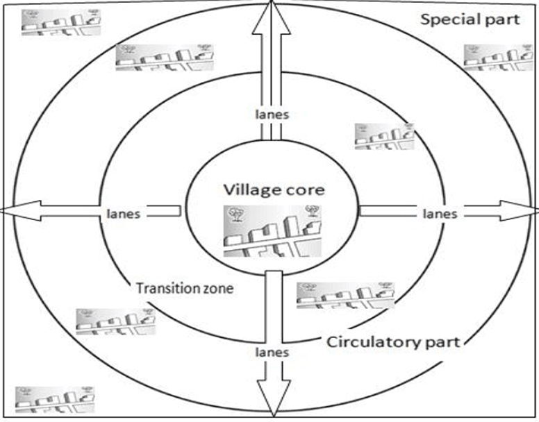
Doxiadis classification of Rural Morphology
- Earliest attempt to classify Rural Morphology was done by Doxiadis.
- He classified rural morphology into four sectors:
- Homogenous sector or Village core:
- It consists of the central part of the village.
- It has a religious site, water body or Zamindar/ Village headman’s house, or community land.
- It is surrounded by the own caste man of village Zamindar.
- It is the most densely populated region and congested part of the village reflecting patriarchal society and security concerns.
- Transitional zone
- This part is occupied by the village servicemen e.g. Goldsmith, Blacksmith, Milkman, weavers, etc.
- This zone is attached with the core of the village where middle caste people are mixed with poor upper caste people.
- This zone is also known as the Artisans zone.
- Circulatory part:
- It is the outer periphery of the village where new houses and settlers have been migrated or settled outward due to congestion of the core.
- Thus, this zone has mixed land use in terms of social structure.
- Special part:
- It was occupied by landless labours outside the village close to farmlands because of work opportunities on-field and social segregation.
- They are usually the people from the lower castes.
Types of Rural Settlement
- Types of rural settlements are determined by various factors such as social interactions, geographical and climatic conditions, and land capacity. The capability of the land is directly related to the concentration of settlements in an area.
- A rural settlement type refers to the arrangement and clustering of houses or villages within a rural landscape, which typically consists of villages, agricultural lands, and pasture lands. The way these settlements are spaced out and arranged in terms of their geometrical proximity across the rural landscape is indicative of the specific settlement type.
- There are various methods to analyze and understand rural settlement types, primarily through statistical analysis. Two common approaches include the nearest neighbor approach and the coefficient of dispersal method. These methods help in understanding the distribution and arrangement of settlements within a rural area, providing valuable insights into the patterns of rural habitation.
Nearest neighbour approach
- In this approach, the degree of nucleation will be presented through an index value.
- It refers to the spacing between either houses or villages over the rural landscape.
Rn is the index value which is derived from the formula
Rn = 2d√(n/A)
Where,
Rn – Index value
d = distance between either houses or villages
n = number of houses or villages
a = total Area of the given landscape under consideration

Coefficient of dispersal method
- Calculation of settlement type through this method is given below
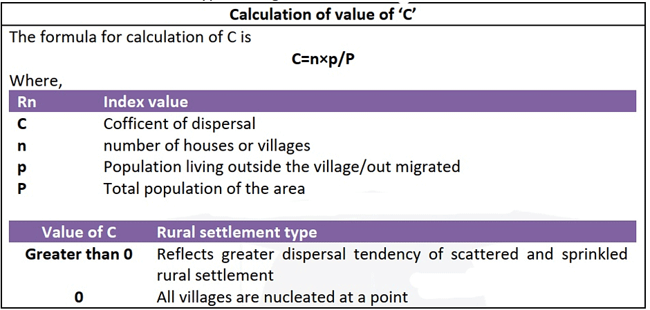
- Above method signifies that greater the value of ‘C’ greater the dispersed settlement.
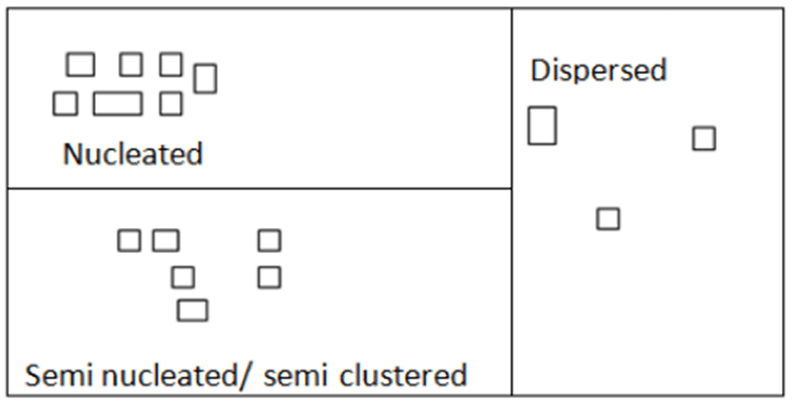
Based on above analysis, there are three types of settlement
- Nucleated/clustered
- Semi nucleated/ semi clustered
- Dispersed
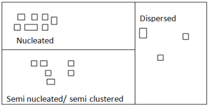
Nucleated/Clustered Rural Type
Advantages of Nucleated/Clustered Rural Type Settlements:
- Efficient use of resources: Due to the close proximity of houses and other structures, resources such as water, electricity, and other utilities can be efficiently distributed and managed.
- Social cohesion: Living in close proximity to one another encourages social interaction and bonding among the community members. This fosters a sense of unity and support among the inhabitants.
- Security: Nucleated settlements provide better security to the residents as they can easily look out for each other in case of any danger or threat.
- Economies of scale: The close proximity of structures and inhabitants makes it easy for businesses and services to thrive in nucleated settlements. This can lead to the growth of local economies and employment opportunities.
- Accessibility: Nucleated settlements often have well-developed transportation networks, making it easy for inhabitants to access essential services such as healthcare, education, and markets.
- Cultural preservation: Nucleated settlements often have a strong sense of identity and culture due to shared customs, beliefs, and traditions. This can lead to the preservation of cultural practices and heritage.
Disadvantages of Nucleated/Clustered Rural Type Settlements:
- Overcrowding: Due to the high degree of nucleation and the close proximity of houses, overcrowding can become a significant issue. This can lead to problems such as lack of privacy, noise pollution, and the spread of diseases.
- Limited land availability: With the increasing population, the availability of land for agriculture, housing, and other developmental activities becomes limited in nucleated settlements.
- Environmental degradation: The high concentration of population and human activities in nucleated settlements can lead to environmental problems such as pollution, waste disposal issues, and deforestation.
- Inadequate infrastructure: Due to the rapid growth of population in nucleated settlements, infrastructure such as housing, road networks, and utilities may not be able to keep up with the increasing demand, leading to inadequate services and living conditions.
- Socio-economic disparities: Nucleated settlements can sometimes lead to socio-economic disparities among the inhabitants, with some sections of the population enjoying better access to resources and opportunities than others.
- Lack of privacy: The close proximity of houses and other structures in nucleated settlements can lead to a lack of privacy for the inhabitants, which can be a significant drawback for some individuals.
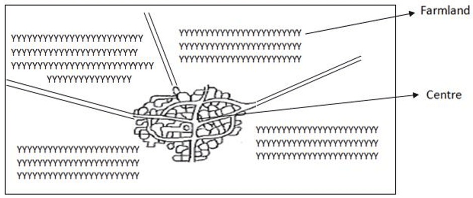
Distribution of Nucleated settlements
- Nucleated settlements are widely found in productive alluvial plains.
- The need for cooperation in agricultural activities like a tilting of land, borrowing of agricultural implements, etc. brings the farmer communities together.
- Uniform relief leads to similarities in lifestyles which foster a sense of brotherhood.
- This is further strengthened by socio-economic bonds formed due to class, kinship, and other linkages. E.g. Indo-Gangetic plains, Nile valley, Huwang Ho valley, etc.
- Hunting and fishing communities:
- Hunting and fishing require collective effort in making, marinating, and handling fishing boats.
- It requires cooperation, management and thus compactness is needed.
- It is observed among American Red Indians, along Brahmaputra, Hooghly river valleys.
- Security:
- The need to defend against wild animals, common enemies leads to the formation of compact or nucleated settlements. Example: Forests and valleys of Shiwalik, western and eastern India, Rajasthan, Punjab, Bundelkhand, etc.
- Compact settlements are found on hilltops and ridges in Nagaland for protection against invasion of head hunters.
- Scarcity of resource:
- When the resources of an area are poor and scanty, the compactness of a settlement enables the maximum utilization of resources.
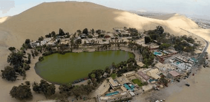
- For example, people in arid region settle around the area with water resources such as Oasis (in Sahara, Rajasthan)
Distribution of Nucleated Settlement in India
- In India, the presence of intensive agriculture often results in the formation of compact settlements. For instance, the Purvas and Majras communities in the Ganga plains have emerged due to the prevalence of intensive agriculture in the region. Similarly, well-planned villages in recently irrigated areas, such as Ferozpur in Punjab and Ganganagar in Rajasthan, also display compact settlement patterns as a consequence of intensive agriculture practices.
- In these compact settlements, one can find that the marketplaces, shops, and religious places are usually situated close to the densely populated center. Additionally, there is a high degree of segregation along caste lines in rural areas with compact settlement types.
- The majority of the world's settlements follow a compact nature, especially in areas with intensive agriculture. Examples of such regions include the Northern Plains of India, cultivable tracts in East China, Egypt, Pakistan, Bangladesh, Mexico, the North West European Plains, and Kenya.
Semi-Compact/Semi Nucleated Settlements
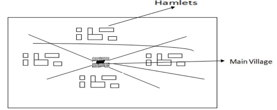
- In rural areas with poor land capability, the rural landscape consists of the houses which are clustered in hamlets
- Here, large land areas need to be cultivated to support small human groups and to avoid the travel distance and to save on time, energy, there is diffusion and dispersal of population
- Here, ‘Rn’ is between 1.5 to 2.5
- The hydrology of the area with a dispersed settlement type is poor.
- The area under dispersed settlement type is in a transitional phase in the growth of the compact settlement.
- With increasing population and adoption of new technologies, the scattered settlements starts taking the shape of semi-compact settlements.
- Examples of semi-compact settlements are
- East of Aravallis in Rajasthan
- Hilly tracts of Madhya Pradesh, Arunachal Pradesh, Meghalaya, Manipur, Mizoram, Tripura, the valley of Brahmaputra.
- Malwa plateau
- Bundelkhand plateau
- Drier parts of Deccan plateau.
Dispersed or Scattered Settlements
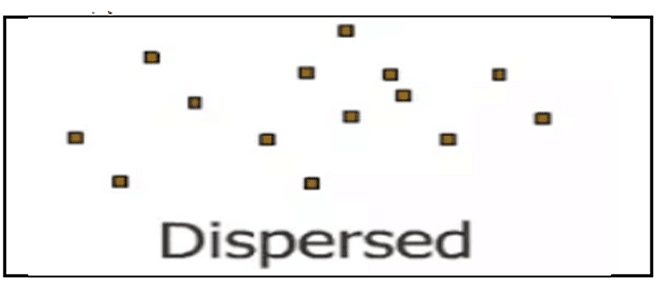
- Villages having dispersed or scattered settlements have farmstead scattered over a much wider area. It reflects poor hydrology and land capability.
- ‘Rn’ for this type of settlement is greater than 2.5.
- Number of houses per unit area in these types of settlements is very low and there is a wide gap between the houses.
- Such Rural Settlements are the characteristics of deserts/semi-arid land with poor land capability or regions affected by natural hazards.
- Such villages are common in:
- Areas of extreme climate
- Hilly tracts
- Deserts
- Thick forests
- Grasslands
- Areas of extensive agriculture.
- Poor agriculture land
- Areas where it is essential for farmers to live on agricultural land rather than distant village settlement
- Dispersed rural settlements are typically more recent developments, as people have sought to move away from densely populated areas in search of new spaces. Technological advancements have enabled people to inhabit even deserts and other harsh environments.
- In the late 19th century, steppe grasslands east of the Urals in Uzbekistan and Russia emerged as dispersed settlements. Similarly, such settlements can be found in large agricultural regions, such as the Prairies in the US and Canada, the Pampas in Argentina, and the Downs in Australia.
- In India, dispersed settlements are present in semi-desert regions like Rajasthan, the forested areas of North East India, the Shiwaliks, Jammu and Kashmir, and various parts of the Peninsular region. These types of settlements can also be found in sparsely populated areas, such as northern Canada, Central Australia, Scandinavian countries, and the western USA.
- Some regions with fertile land and a favorable climate also have dispersed settlements, often due to historical or socio-cultural factors. For instance, when a portion of an overcrowded population leaves a village to establish a new settlement, it often results in a dispersed settlement. This can be observed in the Northern plains, situated between two large, compact settlements.
- Similarly, when people move into marshy lands, Khadar tracts, or marginal upland farms, they require a larger area to support their livelihoods, resulting in isolated farms. Dispersed settlement types can be found in the rain shadow regions of the Western Ghats, as well as in Leh-Ladakh, Kutchh, and western Rajasthan.
 Rural Settlement Forms
- Farmstead
- It includes a cluster of 2 to 3 houses.
- The regions having farmstead are the regions of extensive agriculture.
- Examples- Temperate grassland, Prairies, Downs.
- Hamlet
- It includes cluster of 7 to 9 houses
- It signifies poor land capability, low population density.
- It is found in Rajasthan, UK, Scotland
- Village
- It includes a cluster of more than 10 houses.
Classification of Villages
- Pura:
- The place where a habitat had been in ancient days and where chief habitats are all around or nearby areas is called Pura. These villages have great historical continuity.
- This habitat is the nucleus of the area.
- Khas
- It is also called as Sadate.
- It is the central village that was the center of revenue collection in medieval times.
- Kalan
- Kalan are the larger villages with huge clusters of houses.
- The word Kalan is used for large villages and used at the end of the name of the village i.e. Bound Kalan. People of several classes and castes live in such villages.
- Khurd
- Khurd villages are a small cluster of houses.
- This word is used for small villages
- Khera
- This word is used for small colonies and also for the higher land of the village. Khera has great social value for the village community because almost all the shows such as Ramlila Nautanki, etc. take place here.
- In some areas, the word Khera is used for those places where the rums of an ancient fort are found.
- Nanglay
- It comprises a group of small villages where one village is surrounded by several satellite villages.
Pattern of Rural Settlement
- A pattern of rural settlement refers to the overall design and organization of homes and communities in rural areas.
- This includes the arrangement and physical appearance of buildings, as well as the layout of agricultural lands and transportation routes.
- The concept encompasses not only the geometric shape of structures but also the distribution and arrangement of these elements within the landscape.
- By examining the patterns of rural settlements, one can better understand the planning, organization, and overall structure of these areas.
- Each of the rural settlement types has separate geometrical patterns which is given below.
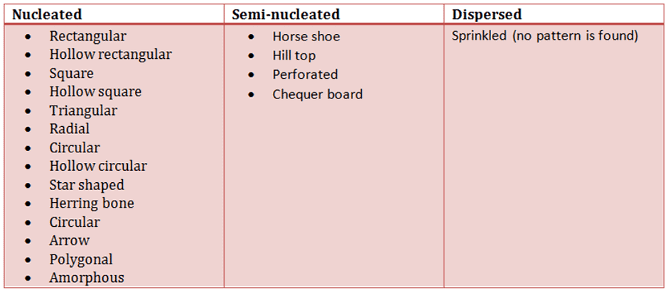
Nucleated Settlements Pattern
Rectangular Pattern- The settlements with rectangular patterns have a high degree of nucleation.
- More than 50% of the world population lives in such settlements.
- This pattern of settlement is most common in India.
- This pattern of settlement is found where the land capability is high
- The areas having this pattern of settlement have a high degree of clustering and high population density.
- The shape of the cultivated land is rectangular.
- Examples (India)
- Most of North Indian villages have rectangular patterns dominated by caste groups.
- Ganga-Yamuna-Doab, Eastern Uttar Pradesh villages, Western Bihar villages.
- Examples (Worldwide)
- Villages of southeast China
- Villages in Myanmar along rivers
- Regions with high population density like well-planned settlements of Germany, Russia, China, Israel, France, etc. (these are the places with planned settlements)
- The settlements with rectangular pattern have narrow meandering streets and lanes
- In the central part, the village headman or old Zamindar house with his own caste man has greater nucleation while away from the center spacing between house increases.

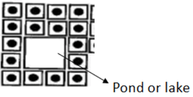
Hollow Rectangular
- If a village develops along a water body, a religious site, or an open community land in the center, it is called a hollow rectangular
- Such villages are typical of wet point settlements.
- E.g. villages over Tamil Nadu Plateau, Deccan Plateau.
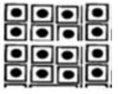
Square Pattern
- It is the modified form of a rectangular pattern.
- The degree of compactness in the square pattern of settlement is high.
- The size of farmland are responsible for such villages.
Hollow Square Pattern
- It is similar to square pattern settlement except for the fact that it consists of some water body, pond, temple, etc. at the center of the settlement.
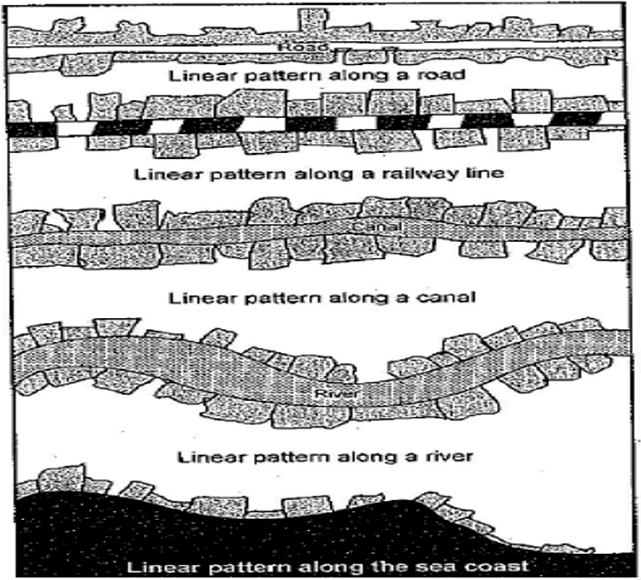
Linear Settlement
- When houses are arranged along the bank of a river or coastline or transportation line, the pattern of settlement formed will be linear.
- Examples of the linear settlement include
- Northern Malabar, Mopla Villages, fisherman villages along roads in Ganga-Yamuna doab.
- Houses along NH-7
- Development of villages along Trans Siberian Railways, Canadian Pacific Highway, Nile Valley, Indus River.
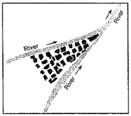
Triangular Pattern (Arrow head pattern)
- When either two roads or two rivers are converging at a point, there will be a clustering of houses either on the doab or between the transportation lines.
- Such villages have limited growth options and their growth is unidirectional.
- Examples:
- Delta of Egypt and Nigeria
- North Bihar, villages, Northern Assam, settlements along NH-7 in MP where Block/district roads are meeting highways.
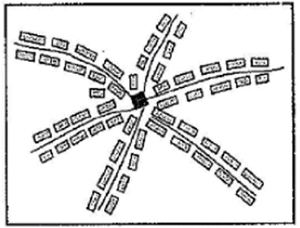
Radial Pattern
- When transportation lines are emerging from a point like over a dome-shaped plateau, the radial pattern develops and the houses cluster around the roads connecting the top of the plateau.
- Examples:
- Villages in Marathwada
- Ridges of Deccan plateau
- Settlements near Haridwar
- Ozark plateau in the USA
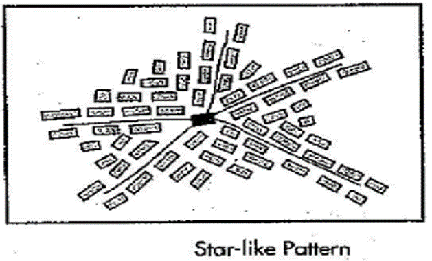
Star Shaped Settlement
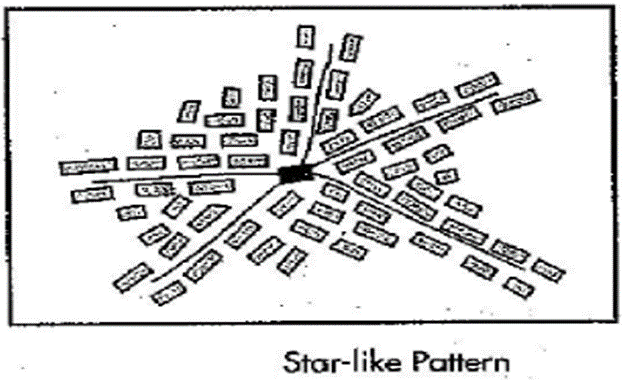
- When space between radial roads gets filled, it gives rise to star shaped settlement.
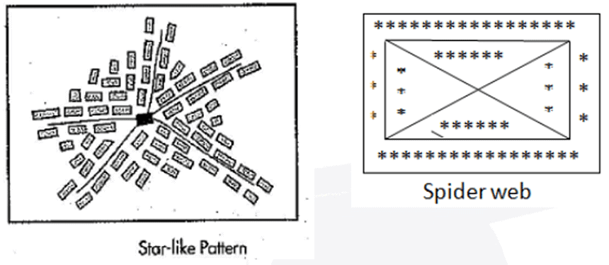
Spider Web Settlement
- When the interconnecting roads between the radial roads attract new houses, then it gives rise to Spider web settlement pattern.
Circular Pattern
- It is a variant of a rectangular pattern.
- Social security and defense play an important role in the development of the circular pattern of settlement beside land capability and hydrology.
- Fisherman and salt producer’s community settle along sea coasts and salt lakes developing a circular pattern of settlement
- Examples:
- Rohilkhand, Ganga-Yamuna Doab
- Masai Tribes of Tanzania, Kraal
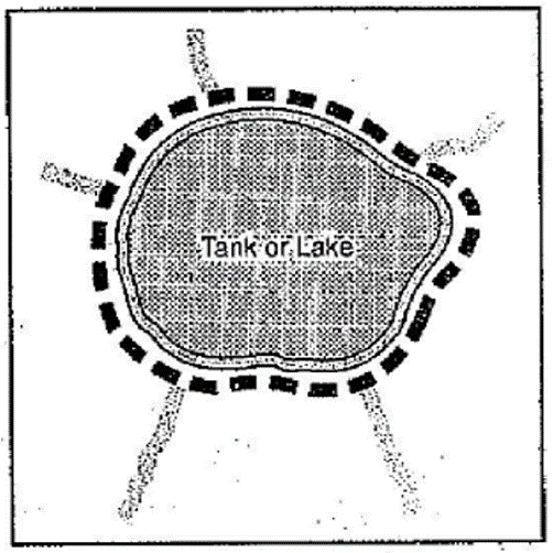
Hollow Circular Pattern
- When the circular pattern of settlement is developed around a central water body it is called as Hollow circular pattern of settlement.
Star Shaped Pattern
- This pattern of settlement develops when three or more transportation lines cross each other.
- Examples:
- NH-47 in Tamil Nadu
- Villages in coastal Orissa
- Alabama mining state of USA
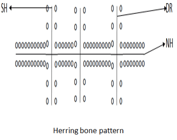
Herring Bone pattern
- When one or major transportation line is crossed by several state highways or district roads at a 90-degree angle, then it gives rise to the Herring Bone pattern of settlement.
- Examples:
- NH-47 in Tamil Nadu (between SalemTrivandrum)
- NH-47 between Bhopal and Bangalore
- Very common in the Eurasian part of the Trans Siberian Railway
- Canadian and Australian villages.
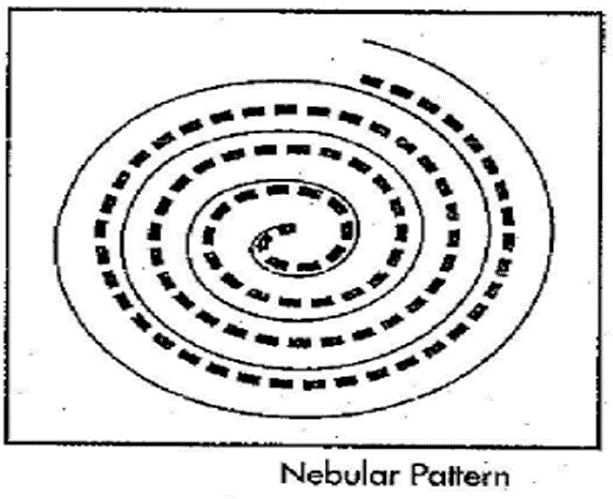
Nebular Pattern
- This type of settlement pattern develops when transportation lines appear like a Nebula of circular ring emerging from centre.
- Such patterns are common in south German villages located over highlands.
- It is uncommon in India but can be found in the Shillong plateau where the expansion of larger villages have the nebular pattern.
- Polygonal pattern
- It is the variant of a rectangular pattern of settlement
- Rectangular settlements in their transitional stage of growth can be either polygonal or amorphous.
- Example: North Gangetic plain
- Amorphous pattern of settlement
- These types of settlements do not have definite shapes.
- Most of them are semi clustered villages that are dispensing out because of centrifugal forces.
- Cruciform settlement pattern
- This type of settlement is found in many European villages due to higher development of transportation routes. The villages are settled in planned way.
- Examples
- Settlements along NH-7 in South India
- South of Bangalore district roads across NH-7
Semi-Nucleated Settlements Pattern
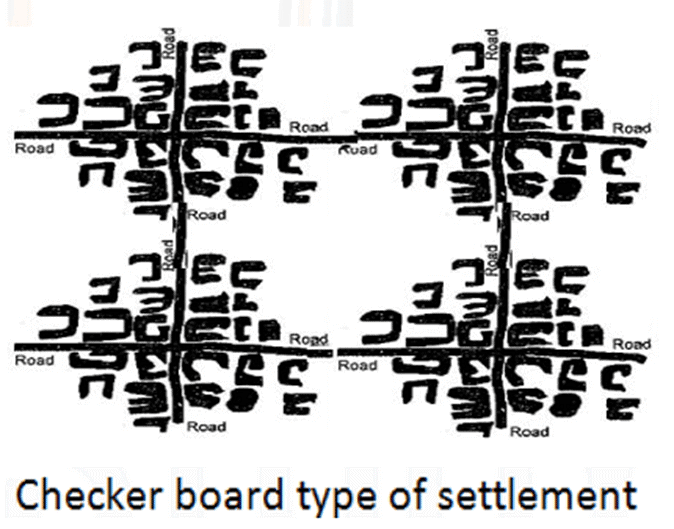
Checker Board Type of Settlement- When semi nucleated eventually becomes nucleated, the transition phase gives rise to the checkerboard type of settlement.
- In this type of settlement, the transport networks are developed so that they form a grid over the landscape.
- There are junction points at the transportation link crossings where the settlements are developed.
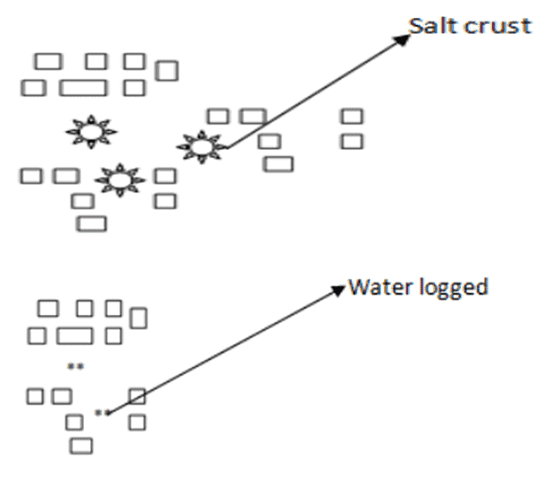
Perforated Settlements
- When the houses in semi nucleated settlements are widely dispersed because of the existence of salt crust as in Marshy lands over Bengal delta, then it gives rise to perforated settlements
- Examples:
- Bangladeshi villages which are affected by the cyclone, floods, and waterlogging.
- Villages in Northern Sahara where sand dunes are located between hamlets.
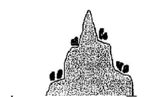
Hill Top Settlements
- These type of settlements are found in Naga villages for the purpose of defense
- Houses are along the edge of top so that the tribes can keep vigil over the movement of enemy tribes.
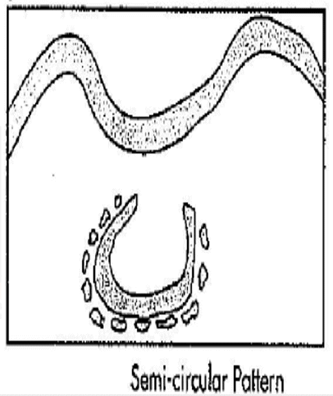
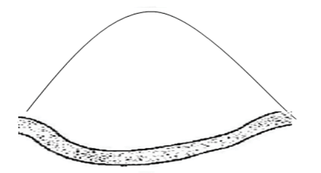
Horse shoe pattern/ semi circular pattern
- It develops along the foothills of mountains and spurs, crescent, or along the banks of the large rivers.
- Examples:
- Villages near Haridwar, Shiwalik, and Bhabhar region.
- Tribal villages of Arunachal Pradesh.
Conclusion
In conclusion, settlement geography explores the various types of human settlements, their formation, and the factors influencing their distribution and morphology. From rural to urban settlements, factors such as land capability, hydrology, socio-economic conditions, and cultural aspects play a significant role in determining the settlement patterns. Nucleated, semi-nucleated, and dispersed settlements, as well as hamlets, villages, towns, cities, and megalopolises, are all examples of different human settlements. Understanding these settlements is essential for planning and managing resources, preserving cultural heritage, and ensuring sustainable development in the face of population growth and environmental challenges.Frequently Asked Questions (FAQs) of Types, Patterns and Morphology of Rural Settlements
What is the difference between rural and urban settlements?
Rural settlements are communities where the majority of residents are involved in primary activities such as agriculture, forestry, mining, or fishing. They consist of disorganized clusters of closely connected houses with poor ventilation and inadequate sewage and drainage systems. Urban settlements, on the other hand, are characterized by tall buildings, broad roads, administrative centers, and recreational spaces, with the majority of the population engaged in secondary (manufacturing) and tertiary (service) sectors.
What are the main factors that influence the distribution and arrangement of rural settlements?
The distribution and arrangement of rural settlements are influenced by various factors such as social interactions, geographical and climatic conditions, and land capability. These factors determine the degree of nucleation or clustering of houses and villages within the rural landscape.
What are the three main types of rural settlements based on their distribution and arrangement?
The three main types of rural settlements based on their distribution and arrangement are nucleated/clustered, semi-nucleated/semi-clustered, and dispersed or scattered settlements.
What are the advantages and disadvantages of nucleated/clustered rural settlements?
Advantages of nucleated/clustered rural settlements include efficient use of resources, social cohesion, security, economies of scale, accessibility, and cultural preservation. Disadvantages include overcrowding, limited land availability, environmental degradation, inadequate infrastructure, socio-economic disparities, and lack of privacy.
In which regions of India can one find examples of the different types of rural settlements?
Examples of nucleated settlements can be found in the Northern Plains of India, cultivable tracts in East China, and other regions with intensive agriculture. Semi-compact settlements can be found east of the Aravallis in Rajasthan, hilly tracts of Madhya Pradesh, and other areas with poor land capability. Dispersed settlements are present in semi-desert regions like Rajasthan, forested areas of North East India, the Shiwaliks, Jammu and Kashmir, and various parts of the Peninsular region.
|
303 videos|636 docs|252 tests
|
FAQs on Types, Patterns and Morphology of Rural Settlements - Geography Optional for UPSC
| 1. What is settlement geography? |  |
| 2. What are nucleated settlements? |  |
| 3. What is a semi-nucleated settlement? |  |
| 4. What factors influence the types and patterns of rural settlements? |  |
| 5. How does settlement morphology vary in rural areas? |  |


