Globe - Latitudes & Longitudes Summary Class 6 Social Science Chapter 2
| Table of contents |
|
| Introduction of the Chapter: |
|
| Parallels of latitudes |
|
| Heat Zones of the Earth |
|
| What are Longitudes? |
|
| Longitude and Time |
|
| Why do we have Standard Time? |
|
| Some Important Questions |
|

Introduction of the Chapter:
In this Class 6 chapter "Globe: Latitudes & Longitudes" we challenge the idea that Earth is a perfect sphere, exploring its unique shape – slightly flattened at the poles and bulging at the equator.
 Globe: Latitudes & Longitudes
- Using the globe as our guide, we'll dive into the significance of latitudes and longitudes, uncovering their role in understanding Earth's geography.
- From practical applications to the importance of the Equator and Prime Meridian, this chapter promises a fascinating exploration of our planet's intricacies.
Let's have a look at Summary of this NCERT Chapter in the document:
Globe & Important Terms Related to it
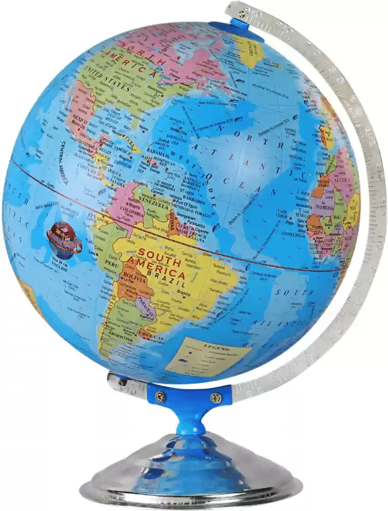
A globe is a spherical model of Earth. It serves purposes similar to some maps. A model globe of Earth is called a terrestrial globe.
 Globe
Globe
- Varying Size and Type: Globe is a true model (miniature form) of the earth. Globes may be of varying size and type – big ones, which cannot be carried easily, small pocket globes, and globe-like balloons, which can be inflated and are handy and carried with ease.
- Not Fixed: The globe is not fixed. It can be rotated the same way as a top spin or a potter’s wheel. On the globe, countries, continents, and oceans are shown in their correct size.
Overview of Important Terms
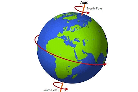
- Axis and Poles: A distinctive feature of the globe is its axis – a needle fixed through it in a tilted manner. This axis serves as a point of reference, representing the Earth's rotational axis. Two crucial points on the globe where the needle passes are the North Pole and the South Pole, signifying the extremes of the Earth's axis.
 Axis and Poles
 - Movement of the Globe: While the globe shares a resemblance with Earth's movement – it can be rotated around its axis from west to east – a significant difference exists. Unlike the real Earth, which moves around its imaginary axis, the globe uses the needle as a simulated axis for illustrative purposes.
- Equator and Hemispheres: The globe introduces another imaginary line, the equator, which horizontally divides it into two equal parts. This equatorial line is of utmost importance, as it distinguishes the Earth into the Northern Hemisphere and the Southern Hemisphere – both halves being equal in size.
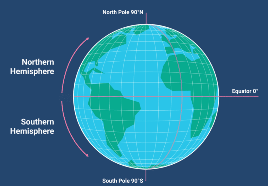 Equator: Northern and Southern Hemisphere
 - Latitudes and Parallel Circles:
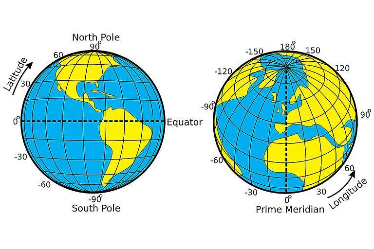
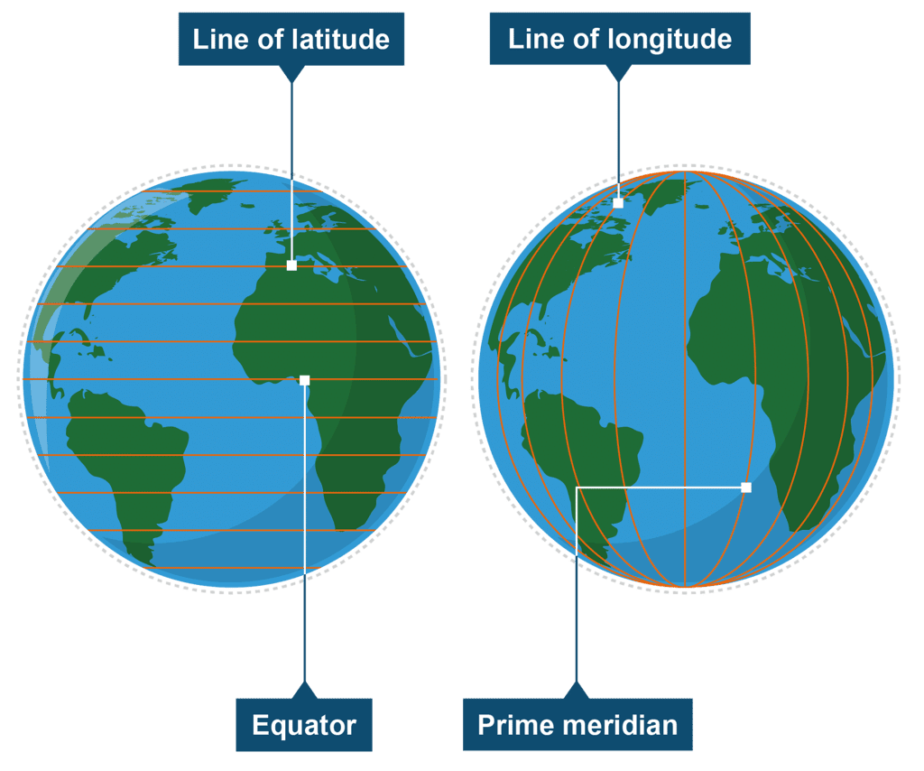
The equator, serving as an imaginary circular line, becomes a crucial reference point for locating places on the Earth. Parallel circles, termed parallels of latitudes, extend from the equator to the poles. Latitudes, measured in degrees, quantify the distance north or south of the equator. For instance, the equator itself represents zero degrees latitude, while 90 degrees north latitude designates the North Pole, and 90 degrees south latitude marks the South Pole.
Parallels of latitudes
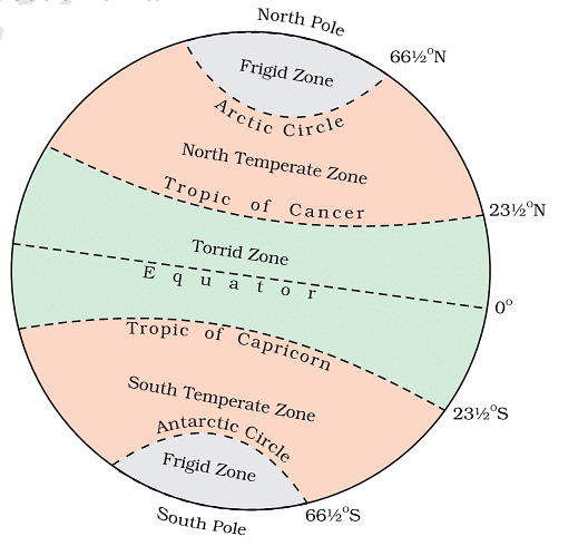
All parallel circles from the equator up to the poles are called parallels of latitudes. Latitudes are measured in degrees.
 Parallel of Latitudes and Heat Zones
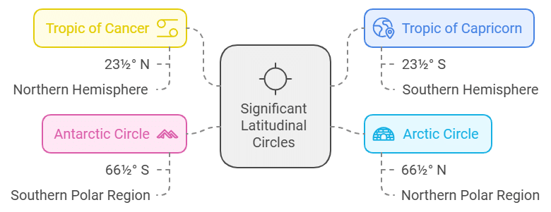
In understanding Earth's geography, certain parallel circles, termed as parallels of latitudes, play a significant role. Beyond the equator (0°), North Pole (90°N), and South Pole (90°S), four critical parallels are noteworthy:
- Tropic of Cancer (23½° N): This imaginary line is located in the Northern Hemisphere, approximately 23½ degrees north of the equator.
- Tropic of Capricorn (23½° S): Situated in the Southern Hemisphere, this parallel rests approximately 23½ degrees south of the equator.
- Arctic Circle (66½° N): Positioned about 66½ degrees north of the equator, the Arctic Circle marks a significant latitude in the Northern Hemisphere.
- Antarctic Circle (66½° S): Conversely, in the Southern Hemisphere, the Antarctic Circle is situated around 66½ degrees south of the equator.
Heat Zones of the Earth
The Earth's heat distribution is intricately linked to its latitudinal zones, creating distinct climatic regions:
 Representation of how sunlight is received at slanting and straight surface
Torrid Zone
- The mid-day sun is exactly overhead at least once a year on all latitudes in between the Tropic of Cancer and the Tropic of Capricorn. This area, therefore, receives the maximum heat and is called the Torrid Zone.
Temperate Zones
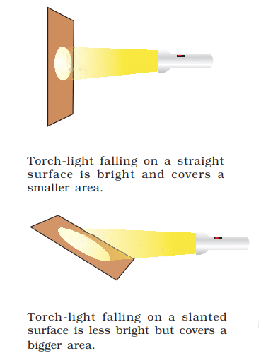
- Extending from the Tropic of Cancer to the Arctic Circle in the Northern Hemisphere and from the Tropic of Capricorn to the Antarctic Circle in the Southern Hemisphere, these zones boast moderate temperatures. This happens because the sun rays come at a slant in these areas. So, this part of the earth receives mild temperature. These zones are called the Temperate Zones.
Frigid Zones
- Areas between the Arctic Circle and the North Pole and those between the Antarctic Circle and the South Pole receive sun rays at a big slant. Due to this, the sun is never much above the horizon. So, this part of the earth receives the least amount of heat and remains very cold. These zones are called Frigid Zones.
What are Longitudes?
The imaginary lines which run from the North Pole to the South Pole, are called longitudes. These are also called meridians of longitude. These lines aid in measuring the east or west distance from a designated meridian.
 Latitudes and Longitudes
- The earth has been divided into 180° longitudes towards the east and 180° longitudes towards the west.
- Prime Meridian: Numbering meridians uniformly was challenging, leading to the adoption of the Prime Meridian. This meridian, passing through Greenwich, serves as the reference point (0° longitude). Counting 180° eastward and westward from the Prime Meridian divides the Earth into the Eastern and Western Hemispheres.
Longitude and Time
The best means of measuring time is by the movement of the earth, the moon and the planets.
- When the Prime Meridian of Greenwich has the sun at the highest point in the sky, all the places along this meridian will have mid-day or noon.
- As the earth rotates from west to east, those places east of Greenwich will be ahead of Greenwich time and those to the west will be behind it.
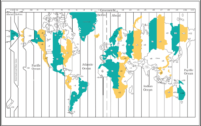 Time Zones of the World
How to Calculate Time?
- The rate of difference can be calculated as follows. The earth rotates 360° in about 24 hours, which means 15° an hour or 1° in four minutes.
- Thus, when it is 12 noon at Greenwich, the time at 15° east of Greenwich will be 15 × 4 = 60 minutes, i.e., 1 hour ahead of Greenwich time, which means 1 p.m.
- But at 15° west of Greenwich, the time will be behind Greenwich time by one hour, i.e., it will be 11.00 a.m. Similarly, at 180°, it will be midnight when it is 12 noon at Greenwich.
Why do we have Standard Time?
The local time of places, which are on different meridians are bound to differ. In India, for instance, there will be a difference of about 1 hour and 45 minutes in the local times of Dwarka in Gujarat and Dibrugarh in Assam.
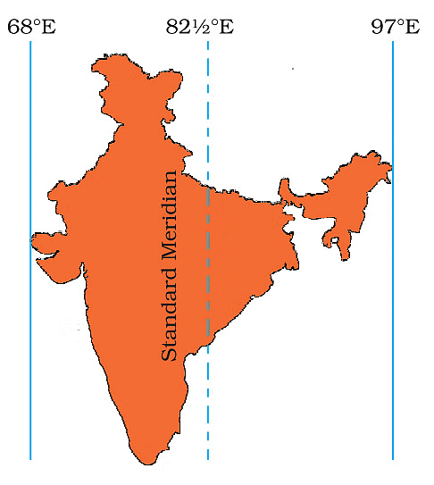 Indian Standard Meridian
- It is, therefore, necessary to adopt the local time of some central meridian of a country as the standard time for the country.
- In India, the longitude of 82½° E (82° 30’E) is treated as the standard meridian. The local time at this meridian is taken as the standard time for the whole country. It is known as the Indian Standard Time (IST).
Some Important Questions
Q.1. What is ‘Standard Time’?
Answer: Standard time is a consistent time adopted for a specific area or country. It is usually determined based on the meridian at the center of the respective time zone.
Q.2. What is ‘Latitude’?
Answer: Latitude is the measurement of the distance of a location north or south of the Equator, expressed in degrees.
Q.3. What are the different zones of Earth?
Answer: The Earth has three primary climate zones: tropical, temperate, and polar, each characterized by distinct temperature and weather patterns.
Q.4. What is the true shape of the Earth?
Answer: The Earth is not a perfect sphere. It is slightly flattened at the North and South Poles and exhibits a bulging shape around the equator.
Q.5. How is time regulated globally?
Answer: Time regulation is achieved globally through the division of the Earth into time zones. Each time zone corresponds to a specific longitudinal region, and standard time is calculated based on the meridian at the center of that zone. This ensures a uniform and organized time system worldwide.
|
297 videos|1066 docs|204 tests
|
FAQs on Globe - Latitudes & Longitudes Summary Class 6 Social Science Chapter 2
| 1. What are latitudes and how do they relate to the heat zones of the Earth? |  |
| 2. What are longitudes and how do they relate to time? | |
| 3. Why do we have standard time? | |
| 4. How are latitudes and longitudes used in navigation? | |
| 5. How do latitudes and longitudes affect climate patterns on Earth? | |


Globe - Latitudes & Longitudes Summary Class 6 Social Science Chapter 2
,practice quizzes
,Previous Year Questions with Solutions
,Sample Paper
,Globe - Latitudes & Longitudes Summary Class 6 Social Science Chapter 2
,Extra Questions
,study material
,past year papers
,Globe - Latitudes & Longitudes Summary Class 6 Social Science Chapter 2
,MCQs
,Summary
,shortcuts and tricks
,Semester Notes
,video lectures
,ppt
,Exam
,Important questions
,mock tests for examination
,Objective type Questions
,Free
,Viva Questions
;


NCERT Summary: Globe - Latitudes & Longitudes Free PDF Download
Importance of NCERT Summary: Globe - Latitudes & Longitudes
NCERT Summary: Globe - Latitudes & Longitudes Notes
NCERT Summary: Globe - Latitudes & Longitudes Class 6 Questions
Study NCERT Summary: Globe - Latitudes & Longitudes on the App
|
© EduRev
|
Education Revolution
|


|


