Geography: May 2023 UPSC Current Affairs | Current Affairs & Hindu Analysis: Daily, Weekly & Monthly PDF Download
| Table of contents |

|
| The Slowdown in Overturning Circulation |

|
| Son River |

|
| Palghat Gap |

|
| Cyclone Mocha |

|
| Galapagos Islands |

|
| Zero Shadow Day |

|
| Anji Khad Bridge |

|
The Slowdown in Overturning Circulation
Why in News?
Recently, Deep Ocean currents in Antarctica are slowing down earlier than predicted, potentially disrupting the crucial overturning circulation.
- The slowdown in circulation and declining oxygen levels in the deep ocean have been observed, indicating significant changes in the Antarctic deep ocean over the past three decades.
- The consequences of this phenomenon are further underscored by the impacts of melting Antarctic ice on the overturning circulation.
What is Overturning Circulation?
- About:
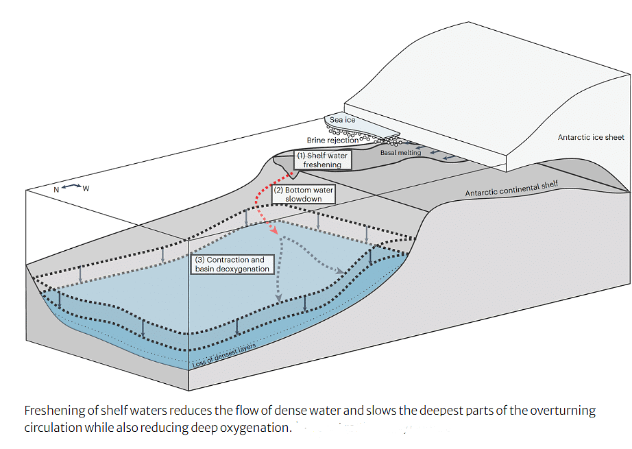
- Overturning circulation refers to the global network of ocean currents that redistribute heat, carbon, and nutrients across the world's oceans.
- In Antarctica, it involves the sinking of dense, oxygen-rich water from the surface, its spread along the sea floor, and slow rise in distant regions.
- Process:
- In polar regions, the surface water cools due to low temperatures and exposure to frigid air masses.
- The cooling leads to the formation of sea ice, which extracts freshwater from the surrounding seawater. This process increases the salinity and density of the remaining water.
- The high salinity and density cause the surface water to become denser, making it more likely to sink.
- The dense water sinks to deeper layers, forming what is known as bottom water.
- The sinking of dense water drives the deeper limb of the overturning circulation. It flows towards the equator, while at the same time, warmer surface water from lower latitudes moves towards the poles.
- As the deep-water travels, it gradually mixes with surrounding water masses, exchanging heat, carbon, and nutrients. Eventually, the upwelling of this modified water occurs in other regions, completing the overturning circulation.
- Importance:
- Overturning circulation plays a crucial role in maintaining climate stability on Earth.
- It facilitates the transport of heat, carbon, and nutrients, influencing the planet's climate system.
- Additionally, it ensures the supply of oxygen to the deep ocean, supporting marine life and its ecosystems.
- Impact of Slowdown in Overturning Circulation:
- The observed slowdown of deep ocean currents in Antarctica, occurring earlier than anticipated, raises concerns about climate stability.
- A reduced flow of bottom water results in a decline in oxygen supply to the deep ocean, impacting oxygen-dependent organisms.
- Lower oxygen levels may lead to behavioral changes, migrations, and disruptions in the marine food chain.
- Moreover, the slowdown amplifies global warming as the ocean's capacity to store carbon dioxide and heat diminishes, intensifying the greenhouse effect.
- Melting Antarctic Ice and its Contribution:
- Melting Antarctic ice disrupts the formation of Antarctic bottom water, making surface waters fresher and less dense, impeding their sinking.
- This disruption weakens the overturning circulation, further diminishing the oxygen supply to the deep ocean.
- The replacement of bottom water with warmer, oxygen-depleted waters exacerbates the decline in oxygen levels.
- Additionally, melting ice contributes to rising sea levels through thermal expansion as warmer water occupies more space.

Son River
Why in News?
The National Green Tribunal (NGT) has issued a directive to halt all mining activities in Son riverbed in Sonbhadra district, Uttar Pradesh.
- The directive addresses illegal mining, imposing environmental compensation on mining companies.
What are the Characteristics of Son River?
- About:
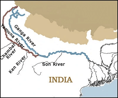
- The Son River, also known as the Sone River, is a perennial river that flows through central India.
- The Son River is the 2nd-largest southern (right bank) tributary of the Ganges after the Yamuna River.
- Geography:
- It originates near Amarkantak Hill in the Gaurela-Pendra-Marwahi district of Chhattisgarh and finally merges with the Ganges River near Patna in Bihar.
- Son forms a series of waterfalls at the edge of Amarkantak plateau.
- It flows through four states: Chhattisgarh, Madhya Pradesh, Uttar Pradesh, and Bihar.
 Tributaries:
- Ghaghar, Johilla, Chhoti Mahanadi, Banas, Gopad, Rihand, Kanhar and North Koel River.
- Prominent Dams and Hydroelectric Projects:
- Bansagar Dam in Madhya Pradesh
- Rihand Dam near Pipri in Uttar Pradesh on Rihand River.
- Indrapuri Barrage in Bihar; it diverts water from the Son River to the Sone Canal System for irrigation purposes.
- Koilwar Bridge constructed in 1862 in Bihar; it serves as India's oldest river bridge, connecting Arrah with Patna.
Palghat Gap
Context
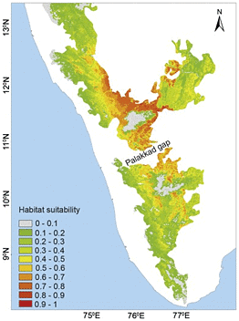
The Palghat Gap in the Western Ghats is a significant break in the mountain range, measuring about 40 km wide.
About the Gap
Information | Details | |
Surrounding hills | It is characterized by the steep Nilgiris and Anamalai hills on either side, both rising above 2,000 meters above sea level. | |
Importance | Gateway into the State of Kerala for roads and railways | |
River flowing through it | Bharathappuzha river | |
Vegetation | Unlike the tropical rainforests found in other parts of the Western Ghats, the vegetation in the Palghat Gap is classified as dry evergreen forest. | |
Shear Zone | Geologically, the Palghat Gap is a shear zone running from east to west.
Shear zones are weak regions in the Earth’s crust, which occasionally result in tremors felt in the Coimbatore region. | |
Origin | The origin of the Gap can be traced back to the separation of Australia and Africa from the Gondwana landmass, causing continental drift. | |
Biogeographic distinctions | Several species of flora and fauna are found only on one side of the Gap. Also, the Mitochondrial DNA of elephants on the Nilgiris side differ from those in Anamalai and Periyar sanctuaries | |
Rainfall | The Western Ghats north of the Palghat Gap receive more annual rainfall, but the south experiences rainfall more evenly distributed throughout the year. | |
Biodiversity South of the Gap | Abundant species richness and diversity. Reason: The warm weather, evenly distributed rainfall, proximity to the equator, and moist air | |
Other gaps | Thal Ghat Pass (Kasara Ghat) (connects Mumbai to Nashik); Bhor Ghat Pass (connects Mumbai to Pune via Khopoli); Amba Ghat Pass (connects: Ratnagiri district to Kolhapur); Naneghat Pass (connects Pune district with Junnar city); Amboli Ghat Pass (connects Sawantwadi of Maharashtra to Belgaum of Karnataka) | |
Cyclone Mocha
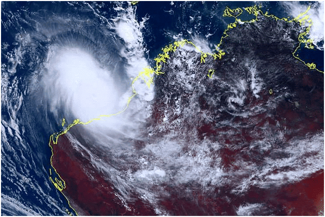
The India Meteorological Department (IMD) recently issued a bulletin forecasting that cyclone Mocha is expected to intensify into a severe storm.
- About Cyclone Mocha:
- It is a tropical cyclone formed over the southern Bay of Bengal.
- The cyclone's name ‘Mocha’ is suggested by Yemen and was named after the Red Sea port city, which is known to have introduced coffee to the world.
- How a Tropical Cyclone Formed?
- A tropical cyclone is formed only over warm ocean waters near the equator.
- Warm, moist air rises up and away from the ocean surface, creating an area of low pressure.
- It causes the air from surrounding areas with higher pressure to move towards the low-pressure area.
- This leads to the warming up of air and causes it to rise above.
- As the air rises & cools, the water in the air forms clouds.
- This complete system of clouds and wind spins & grows, along with the ocean’s heat.
- As the wind rotation speed increases, an eye gets formed in the middle.
- Characteristics of a Tropical Cyclone:
- The centre of a cyclone is very calm and clear with very low air pressure.
- The average speed is 120 kmph.
- They have closed isobars which leads to greater velocity. Isobars are imaginary lines on a weather map that connect locations with equal atmospheric pressure.
- They develop over oceans and seas only.
- They move from east to west under the influence of trade winds.
- They are seasonal in nature.
- How are Cyclones Classified?
- Cyclones are classified on the basis of wind speed by the Indian Meteorological Department (IMD):
- Depression: Wind speeds of between 31–49 km/h
- Deep Depression: Between 50-61 km/h
- Cyclonic Storm: Between 62–88 km/h
- Severe Cyclonic Storm: Between 89-117 Km/h
- Very Severe Cyclonic Storm: Between 118-166 Km/h
- Extremely Severe Cyclonic Storm: Between 166-221 Km/h
- Super Cyclonic Storm: Above 222 Km/h
Galapagos Islands
Why in News?
- According to a recent study, Cold ocean currents have sheltered the Galápagos Islands from global warming.
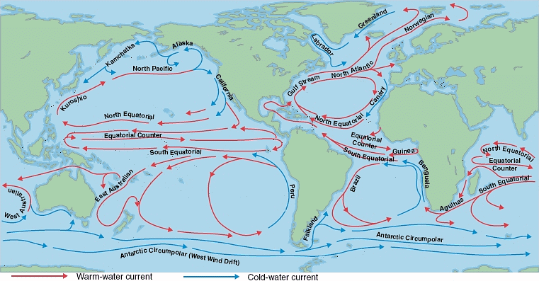
- The islands are protected from an otherwise warming the Pacific Ocean by a cold, eastward equatorial ocean current.
- The equatorial undercurrent in the Pacific Ocean is bound to the equator by the force of the planet’s rotation. Under the ocean’s surface, a swift circulation of cold, nutrient-rich water flows from west to east.
What is Galapagos Archipelago?
- Location:
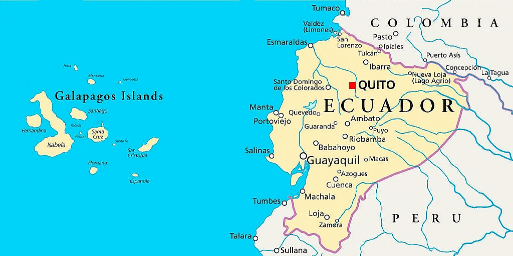
- The Galapagos Islands, spread over almost 60,000 sq km, are a part of Ecuador.
- These are located in the Pacific Ocean around 1,000 km away from the South American continent.
- Protection Status:
- Ecuador made a part of the Galapagos a wildlife sanctuary in 1935, and the sanctuary became the Galapagos National Park in 1959.
- In 1978, the islands became UNESCO’s first World Heritage Site.
- Wildlife:
- It contains aquatic species such as manta rays and sharks which have been endangered by commercial fishing.
- It also hosts a wide array of aquatic wildlife, including marine iguanas, and waved albatrosses.
- Galápagos is home to the critically endangered — Galápagos penguin, Galápagos fur seal and Galápagos sea lion.
- Also, the giant tortoises found here – 'Galápagos' in old Spanish – give the islands its name.
- Significance:
- The British naturalist Charles Darwin made key observations in 1835 that shaped his theory of evolution.
- Darwin described the islands as a “world in itself”.
- Corals do not bleach and die in these waters off the west coast of Ecuador.
What are Ocean Currents?
- About:
- Ocean currents are the continuous, predictable, directional movement of seawater. It is a massive movement of ocean water that is caused and influenced by various forces. They are like river flows in oceans.
- Types:
- Cold currents: It brings cold water into warm water areas. These currents are usually found on the west coast of the continents in the low and middle latitudes (true in both hemispheres) and on the east coast in the higher latitudes in the Northern Hemisphere.
Examples: Canary Current, California Current, Benguela Curren etc. - Warm currents: It brings warm water into cold water areas and is usually observed on the east coast of continents in the low and middle latitudes (true in both hemispheres).
Examples: North Atlantic, Gulf Stream, the Kuroshio Current etc.
- Cold currents: It brings cold water into warm water areas. These currents are usually found on the west coast of the continents in the low and middle latitudes (true in both hemispheres) and on the east coast in the higher latitudes in the Northern Hemisphere.
Which are the Factors that Influences Ocean Current?
- Ocean Currents are Influenced by Two types of Forces:
- Primary Forces:
- Heating by solar energy: Heating by solar energy causes the water to expand. That is why, near the equator the ocean water is about 8 cm higher in level than in the middle latitudes. This causes a very slight gradient and water tends to flow down the slope.
- Wind: Wind blowing on the surface of the ocean pushes the water to move. Friction between the wind and the water surface affects the movement of the water body in its course.
- Gravity: Gravity tends to pull the water down the pile and create gradient variation.
- Coriolis Force: The Coriolis force intervenes and causes the water to move to the right in the northern hemisphere and to the left in the southern hemisphere.
- These large accumulations of water and the flow around them are called Gyres.
- These produce large circular currents in all the ocean basins.
- Primary Forces:
- Secondary Forces:
- Differences in Water Density: Water with high salinity is denser than water with low salinity and in the same way cold water is denser than warm water.
- Denser water tends to sink, while relatively lighter water tends to rise.
- Temperature of Water: Cold-water Ocean currents occur when the cold water at the poles sinks and slowly moves towards the equator.
- Warm-water currents travel out from the equator along the surface, flowing towards the poles to replace the sinking cold water.
Zero Shadow Day
In News
- At 12:17 PM IST on April 25, Bengaluru and at all places along the 130 north Latitude experienced a ‘Zero Shadow Day’.
What is ‘Zero Shadow Day’(ZSD)?
- A ZSD is a day on which the Sun does not cast a shadow of an object at solar noon, when the sun will be exactly at the zenith position(highest point in the sky)
- ZSD happens twice a year for locations in the tropics (between the Tropic of Cancer at +23.5 degrees of latitude and the Tropic of Capricorn at -23.5 degrees of latitude). So, places north of Ranchi in India does not have Zero shadow day.
- One ZSD falls during Uttarayan (movement of the Sun from south to north from winter solstice to summer solstice) and one other during Dakshinayan (back from north to south).
- The dates will vary for different locations on Earth.
Why does a ZSD happen?
- Uttarayan and Dakshinayan happen because Earth’s rotation axis is tilted at an angle of roughly 23.5° to the axis of revolution around the Sun.
- When the Sun is at the zenith its rays make the shadow exactly under it, making it look like no shadow.
Anji Khad Bridge
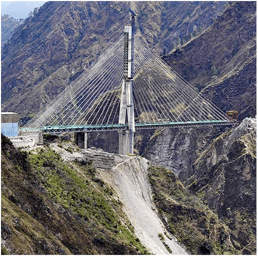
All 96 cables on the first cable-stayed bridge in India, the Anji Khad bridge, have been fully installed in a record time of 11 months.
About Anji Khad Bridge
- It is an under-construction rail bridge in Jammu & Kashmir on the Indian Railways Jammu – Baramulla rail line.
- It will connect the Union Territory of Kashmir with the rest of the country by train.
- It is constructed over the Anji River, a tributary of the Chenab River between Katra and Reasi.
- Anji Khad Bridge will be the first cable-stayed railway bridge in the country.
- It is an asymmetrical cable-stayed bridge balanced on the axis of a central pylon.
- The total length of the structure is 25 metres.
- It stands at a height of 331 meters above the river bed.
- The bridge has a single-line railway track and a 3.75-metre-wide service road.
- The project is being executed by Konkan Railway Corporation Limited (KRCL) and Hindustan Construction Company.
|
44 videos|5271 docs|1113 tests
|

