Geography: January 2024 Current Affairs | Current Affairs: Daily, Weekly & Monthly - CLAT PDF Download
| Table of contents |
|
| 150 Years of India Meteorological Department |
|
| Rock Glaciers |
|
| Krishna-Godavari Basin |
|
| Chilika Lake |
|
| Timor-Leste |
|
| Okinawa |
|
| Willingdon Island |
|
| Aigai |
|
| Torkham Border |
|
| Baltic Sea |
|
150 Years of India Meteorological Department
Context
The India Meteorological Department (IMD), tasked with delivering public weather services, will reach its 150th anniversary on January 15, 2025. In honor of this significant achievement, IMD intends to host a year-long nationwide celebration across all its sub-offices from January 15, 2024, to January 15, 2025.
What is India Meteorological Department (IMD)?
- About:
- It is the National Meteorological Service of the country and the principal government agency in all matters relating to meteorology and allied subjects.
- It is an agency of the Ministry of Earth Sciences, Government of India.
- Objectives:
- To take meteorological observations and to provide current and forecast meteorological information for optimum operation of weather-sensitive activities like agriculture, irrigation, shipping, aviation, offshore oil explorations, etc.
- To warn against severe weather phenomena like tropical cyclones, norwesters, duststorms, heavy rains and snow, cold and heat waves, etc., which cause destruction of life and property.
- To provide meteorological statistics required for agriculture, water resource management, industries, oil exploration and other nation-building activities.
- To conduct and promote research in meteorology and allied disciplines.
How has the IMD Evolved Over The Years?
- Historical Background:
- In 1864, two devastating cyclones hit Kolkata and the Andhra coast, causing significant loss of life.
- The severity of these calamities highlighted the absence of a system to monitor atmospheric parameters, leading to the establishment of the India Meteorological Department (IMD) in 1875.
- Evolution of IMD:
- The IMD commenced its official operations with the appointment of just one individual, HF Blanford, an Englishman recognized as the Imperial Meteorological Reporter.
- Under the leadership of Gilbert Walker, appointed as the head of IMD in 1903, significant progress was made in understanding monsoons.
- Walker identified large-scale oscillations in atmospheric circulations, laying the foundation for modern comprehension of the El Niño phenomenon.
- Over 150 years, IMD has grown into a massive organization with permanent observatories and automatic weather stations across the country.
- Advancements in Cyclone Forecasting:
- The IMD experienced a pivotal moment in 1999 during the Odisha super cyclone, prompting significant investments in technology and manpower. Since then, cyclone-related casualties have notably decreased, attributed to IMD's effective forecasts.
- IMD’s cyclone forecasts now serve not just India but the entire neighbourhood, with as many as 13 countries in the region operating their cyclone management systems using these forecasts.
- Diversified Roles:
- Initially focused on weather forecasting, IMD now provides specialized services for elections, sporting events, space launches, and various sectors.
- Global Role and Recognition:
- IMD's enhanced capabilities have led to its recognition as the Regional Climate Centre for South Asia.
- IMD has partnered to contribute to the United Nations’ ‘Early Warning for All’ programme, for which 30 countries have been identified.
Rock Glaciers
A recent investigation unveiled more than 100 active permafrost features identified within the Jhelum basin, posing the potential for catastrophic disasters in the future.
About Rock Glaciers
- A rock glacier is a mass of rock, ice, snow, mud, and water that moves slowly down a mountain under the influence of gravity.
- Unlike an ice glacier, rock glaciers usually have very little ice visible at the surface.
- The rock glacier might consist of a mass of ice covered by rock debris, or it might consist of a mass of rock with interstitial ice.
- Formation:
- Rock glaciers typically form in mountainous regions where there is a combination of permafrost, rock debris, and ice.
- One common scenario involves a pre-existing glacier that accumulates debris and rocks as it moves.
- Over time, if the glacier recedes or thaws, the debris-covered ice can transform into a rock glacier.
- These are classified as ‘active’ or ‘relict’ to indicate the status of permafrost within them, identified by the appearance of the rock surfaces.
- Impacts
- It increases the risk of glacial lake outburst floods (GLOFs).
- It may also make landslides more frequent with the land on the melting ice becoming loose.
Krishna-Godavari Basin
Context
The Oil and Natural Gas Corporation (ONGC) has initiated crude oil extraction from its extensive deep-sea venture in the Krishna-Godavari (KG) basin. This project encountered numerous delays and deadline extensions in recent years. Situated approximately 35 km off the Andhra Pradesh coastline, it has finally commenced operations.
- This project is expected to add 7 percent each to India’s current production of oil and natural gas.
- Large projects like KG-DWN-98/2 are critical to the country’s objective of reducing its reliance on oil and gas imports to meet its rapidly growing energy needs.
- India is the world’s third-largest consumer of crude oil and depends on imports to meet over 85 percent of its requirement.
- The country is also a major importer of natural gas, as domestic gas output is able to meet around 50 per cent of the demand.
- The location of the oil well is 30 km in the Bay of Bengal off the coast of Kakinada.
Significance of oil production in Krishna-Godavari Basin
India is the third largest consumer and importer of crude oil in the world.
The oil production at KG basin will help in:
- Significant reduction of import bill
- Boosting India’s energy security
- Providing boost to India’s economy
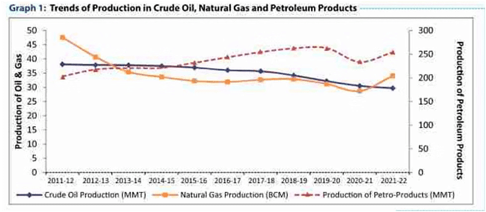
As evident from the above graph, India’s domestic crude oil production has been on a decreasing trend since 2011-12. In this situation, the start of crude oil production from KG Basin will significantly enhance India’s domestic crude production.
About Krishna-Godavari Basin
- Krishna Godavari basin refers to extensive deltaic plain formed by two rivers Krishan & Godavari formed on the coast of Andhra Pradesh and the adjoining areas of Bay of Bengal.
- KG Basin is a proven petroliferous basin of continental margin located on the east coast of India.
- The onland area of KG Basin covers an area of 15,000 sq km and offshore part covers an area of 25,000 sq km up to 1000 m isobath.
- The basin contains about 5 km thick sediments with several cycles of deposition ranging from Late Carboniferous to Pliestocene.
- KG basin is also rich in Shale Gas.
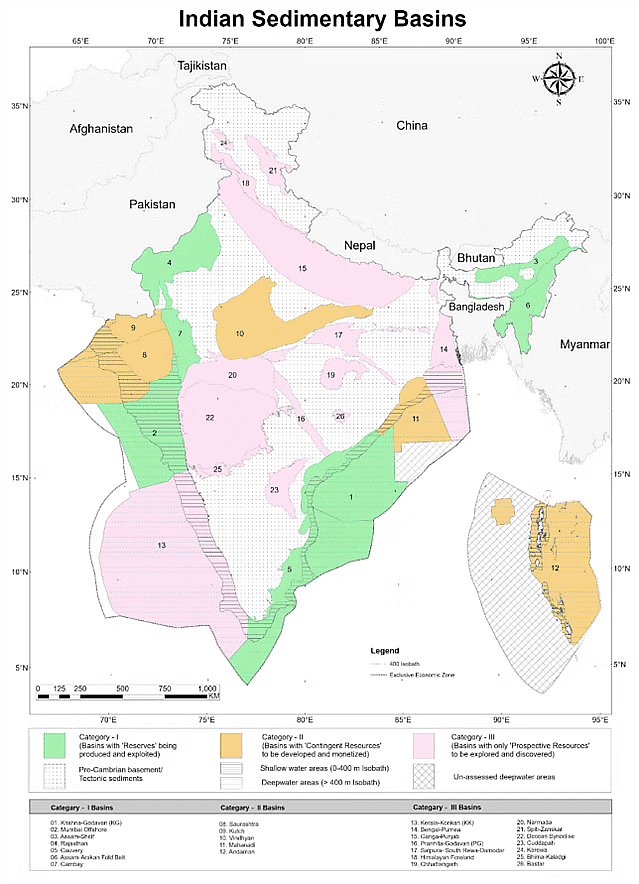
Major sedimentary basins of India
- India has an estimated sedimentary area of 3.36 million sq km comprising 26 sedimentary basins. Of this 1.63 sq km is on land, shallow offshore upto 400m – isobath have an areal extent of 0.41 sq km and deep water beyond 400m isobath having sedimentary area of 1.32 sq km.
- Of the total sedimentary area, 49% of total area is located onland, 12% in shallow water and 39% in the deepwater area.
Basins are categorised as follows:
Category I: (Basins with reserves being produced and potential to be exploited at increased recovery)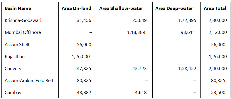 Category II: Basins with contingent resources to be developed and produced
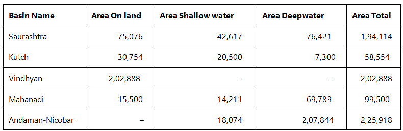 Category III: Basins with only prospective resources to be explored and discovered
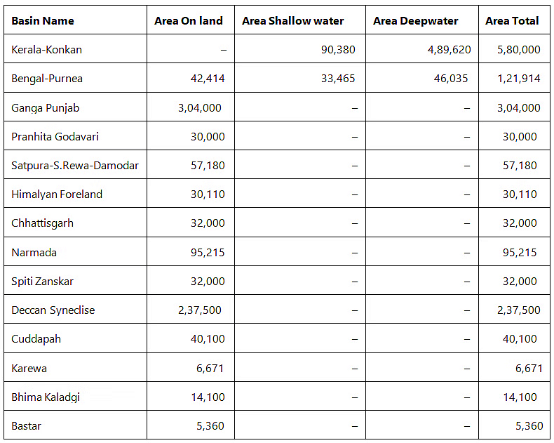
Directorate General of Hydrocarbons (DGH)
- DGH is a regulatory body under the administrative control of Ministry of Petroleum and Natural Gas (MoPNG) established in 1993.
- The body was created by a notification of Ministry of Petroleum and Natural Gas.
- DGH has an Advisory Council appointed by the Government who are eminent persons in the field of hydrocarbon exploration and production.
Functions of Directorate General of Hydrocarbons (DGH)
- Provide technical advice to MoPNG on issues relevant to exploration and optimal exploration and exploitation of hydrocarbons
- A nodal agency for implementation of NELP and CBM policy on behalf of Ministry of Petroleum & Natural Gas
- To review the exploration programs of companies operating under Petroleum Exploration Licenses granted under the Oilfields (Regulation and Development) Act, 1948 and the Petroleum and Natural Gas Rules, 1959 with a view to advising Government on the adequacy of these programs.
- To evaluate the hydrocarbon reserves discovered and estimated by the operating companies
- To advise the Government on the offering of acreages for exploration to companies as well as matters relating to relinquishment of acreage by companies
- To review the development plans for commercial discoveries of hydrocarbon reserves proposed by the operating companies and advise Government on the adequacy of such plans and the exploitation rates proposed and matters relating thereto
- To review and audit concurrently the management of petroleum reservoirs by operating companies and to advise on any mid-course correction required to ensure sound reservoir management practices in line with the optimal exploitation of reserves and the conservation of petroleum resources
- To regulate the preservation, upkeep and storage of data and samples pertaining to petroleum exploration, drilling, production of reservoirs etc. and to cause the preparation of data packages for acreage on offer to companies
- All other matters incidental thereto and such other functions as may be assigned by Government from time to time
- Assist Government in Contract management functions
- Exploration & Development of unconventional hydrocarbon resources like Gas Hydrate, Shale Gas/Oil and Oil Shale
- Issue Essentiality Certificate for indigenous procurement of goods used in E&P sector to avail GST concession.
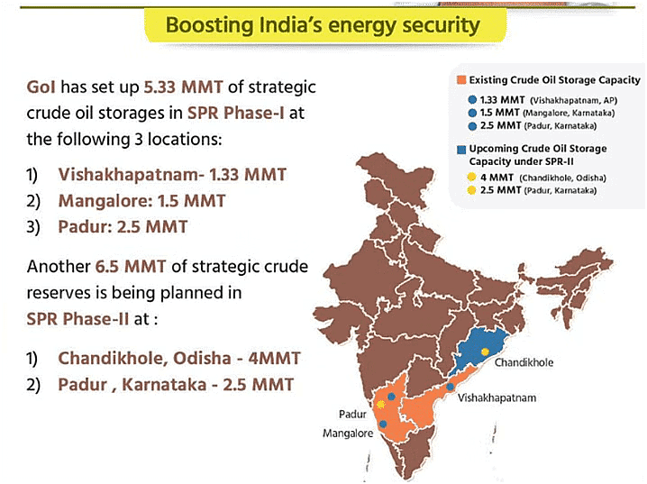
- In 2004, the Government of India, aiming to enhance the nation's energy security, opted to construct Strategic Petroleum Reserves (SPRs) facilities.
- Additionally, a Special Purpose Vehicle (SPV) was established to oversee the building and operation of strategic crude reserves. The Indian Strategic Petroleum Reserve Limited (ISPRL) was established as a wholly owned subsidiary of the Oil Industry Development Board (OIDB), functioning as a Body Corporate.
- During Phase-I of the SPR program, ISPRL completed the construction and filling of underground rock caverns with a total capacity of 5.33 MMT at three locations: Visakhapatnam (1.33 MMT) in Andhra Pradesh, and Mangalore (1.5 MMT) and Padur (2.5 MMT) in Karnataka.
- These reserves are intended for emergency use, especially in the event of significant disruptions in the global crude oil supply chain. The Abu Dhabi National Oil Company (ADNOC), the national oil company of the UAE, participated in Phase-I of India's SPR program.
- Moreover, the Union Cabinet granted approval for the establishment of an additional 6.5 MMT of Strategic Petroleum Reserves at two locations: Chandikhol (4 MMT) in Odisha and Padur (2.5 MMT) in Karnataka.
- This expansion also includes the installation of two dedicated Single Point Mooring (SPM) systems for Padur and Chandikhol, along with associated pipelines, under a Public-Private Partnership (PPP) model, as part of Phase-II.

Chilika Lake
Context
According to the 2022 water bird status survey conducted at Chilika Lake, nearly 1.1 million water birds and species dependent on wetlands visited the lake. Chilika Lake stands as the largest brackish water lake and a vital wintering ground for birds in the Indian subcontinent.
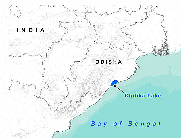
Key Points
- About Chilika Lake:
- Chilika is Asia's largest and world's second largest lagoon.
- In 1981, Chilika Lake was designated the first Indian wetland of international importance under the Ramsar Convention.
- Major attraction at Chilika is Irrawaddy dolphins which are often spotted off Satapada Island.
- The large Nalabana Island (Forest of Reeds) covering about 16 sq km in the lagoon area was declared a bird sanctuary in 1987.
- Kalijai Temple - Located on an island in the Chilika Lake.
- Chilika lake hosts birds migrating from thousands of miles away from the Caspian Sea, Lake Baikal, Aral Sea, remote parts of Russia, Kirghiz steppes of Mongolia, Central and South East Asia, Ladakh and the Himalayas.
- The birds find the vast mud-field and abundant fish stock here suitable to congregate.
- Migratory Species in India:
- India is a temporary home to several migratory animals and birds.
- The important among these include Amur Falcons, Bar-headed Geese, Black-necked cranes, Marine turtles, Dugongs, Humpback Whales, etc.
- India has also launched the National Action Plan for the conservation of migratory species under the Central Asian Flyway as India is a party to Convention on Migratory Species (CMS).
Timor-Leste
Introduction
Prime Minister of India engaged in bilateral discussions with Timor-Leste President Jose Ramos-Horta at Mahatma Mandir in Gandhinagar, setting a new precedent for diplomatic relations between the two nations.
Historical Context
India's recognition of Timor-Leste's sovereignty soon after its independence in 2002 marked the beginning of formal diplomatic ties. Since then, both countries have strived to strengthen their relationship through various channels.
Economic and Development Cooperation
Bilateral trade between India and Timor-Leste, while modest, has seen consistent growth over the years. A closer look at trade statistics reveals the dynamics of this economic relationship:

India's assistance in Timor-Leste's development journey has been notable, spanning infrastructure, capacity building, and human resource development projects.
Agreements and MOUs
Both nations have signed bilateral agreements and Memoranda of Understanding (MOUs) across various sectors such as trade, education, culture, and technology, reflecting a commitment to deepening cooperation.
Capacity Building and Development Cooperation
India has been a steadfast partner in Timor-Leste's capacity building efforts, offering training slots, scholarships, and support in diplomatic training. Furthermore, India's contribution extends to grants for infrastructure projects and healthcare assistance.
Projects and Initiatives
- Several notable projects underline India's commitment to Timor-Leste's progress:
- Establishment of a Centre of Excellence in IT
- Bamboo Skills Development and Demonstration Centre
- Projects under IBSA Fund and India – UN Development Partnership Fund
Indian Community and Peacekeeping
The Indian community in Timor-Leste, comprising advisors, entrepreneurs, and professionals, has actively contributed to the nation's development. Additionally, both India and Timor-Leste have participated in UN Peacekeeping missions, showcasing their shared commitment to global peace.
Challenges and Opportunities
While economic opportunities abound, Timor-Leste faces developmental challenges that India's expertise in healthcare, education, and technology can address. Moreover, geopolitical dynamics necessitate a nuanced approach to diplomacy.
Timor-Leste's Role in India's Act East Policy
Timor-Leste occupies a strategic position in India's Act East Policy, offering avenues for economic engagement, diplomatic cooperation, and security partnerships. Noteworthy aspects of this relationship include:
- Strategic Geopolitical Location
- Economic Engagement
- Diplomatic Cooperation
- Cultural Exchanges
- Strategic Partnership and Security Cooperation
- ASEAN Connectivity
- Energy Security
- Humanitarian Assistance and Disaster Relief (HADR)
Conclusion
The evolving partnership between India and Timor-Leste holds immense potential across diplomatic, economic, and developmental domains. As both nations continue to collaborate, Timor-Leste's role in India's Act East Policy remains pivotal, contributing to regional stability and prosperity.
Okinawa
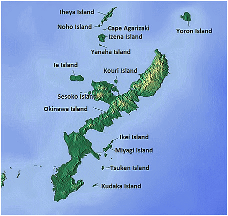
Context
Japan Resumed Landfill Work at New US Military Site on Okinawa.
About:
- Okinawa Prefecture is located in the eastern part of the Asian continent.
- It is the southwestern most point of the Japanese archipelago.
- It is located between Taiwan and Kyushu, the southwestern most of Japan's four main islands. Okinawa remains under Japanese administration today.
- Okinawa comprises 160 islands of varied sizes and enjoys warm and pleasant temperatures throughout the year.
- The warm Kuroshio Current flows through the clear ocean waters of Okinawa, creating an environment in which coral, f ish, and other sea creatures thrive.
- It is the only region in Japan that is in the subtropical zone, and is blessed with a warm climate all year round.
Willingdon Island
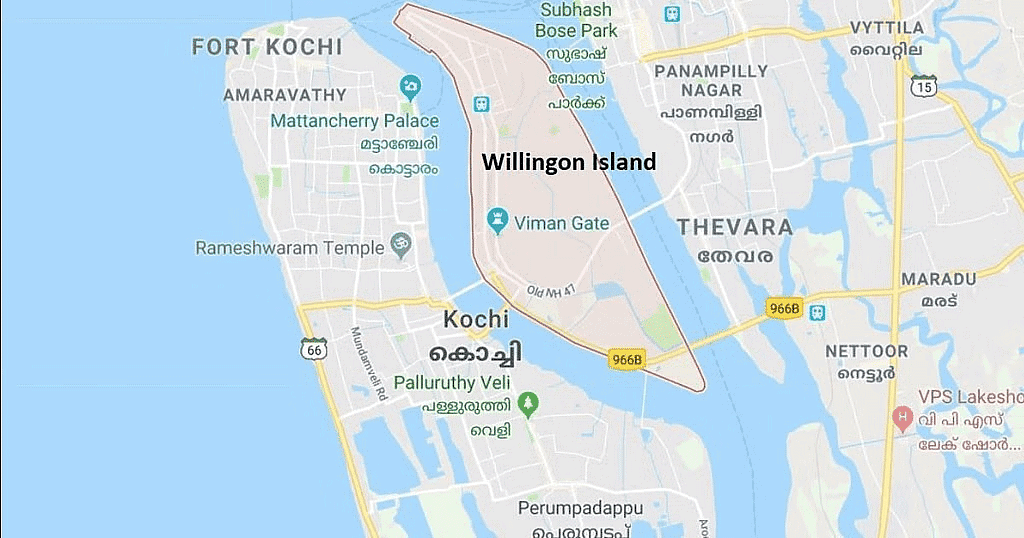
Context
The Cochin Port Joint Trade Union Forum has appealed to the Prime Minister to revive commercial activities on Willingdon Island.
About
- It was created during the construction of the modern port of Kochi in 1936. It is named after the then Viceroy of India, Lord Willingdon.
- Location: The island is located between the backwaters of Kochi (Kochi Lake) and the Arabian Sea.
- Accessibility: It is connected to the mainland by road and railway bridges. It serves as an important transportation hub.
- Port Facilities: It houses the Kochi Naval Base and the headquarters of the Southern Naval Command of the Indian Navy.
- Commercial Hub: The island is a major commercial and industrial center in Kochi, hosting offices, hotels, and warehouses. It is known for its vibrant economic activities.
- Naval Infrastructure: Apart from the naval base, the island has naval establishments, including the Southern Naval Command Maritime Museum.
- Cruise Terminal: The island hosts the Cochin Port Trust's main cruise terminal, facilitating cruise tourism in the region.
 |
Download the notes
Geography: January 2024 Current Affairs
|
Download as PDF |
Aigai
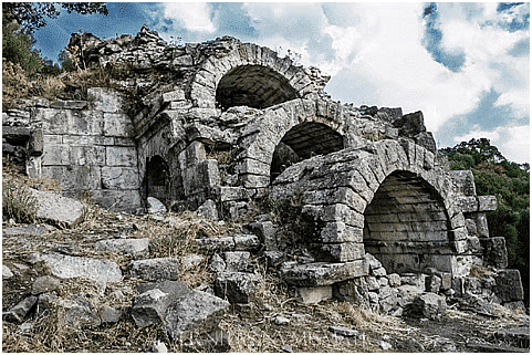
Context
The ancient Palace of Aigai reopened after a 16-year.
About
- The city of Aigai was the ancient first capital of the Kingdom of Macedonia.
- It was discovered in the 19th century near Vergina, in northern Greece.
- The most important remains are the monumental palace, lavishly decorated with mosaics and painted stuccoes, and the burial ground.
- Alexander the Great was crowned in the ancient Palace of Aigai.
- It was built by Philip II, the father of Alexander the Great, the tombs of Philip and other Macedonian kings are nearby. After the assassination of his father, Alexander was crowned at the palace in 336 BC.
- The palace and the nearby tombs are listed as a World Heritage Site by UNESCO.
Torkham Border
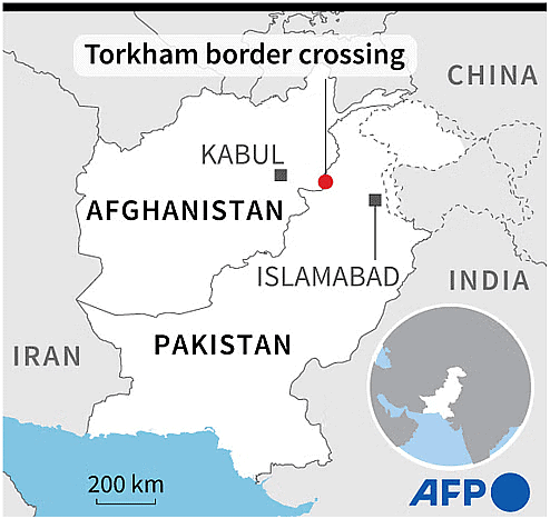
Context
Trade between Pakistan and Afghanistan resumed recently after the two sides reopened a key northwestern border crossing-Torkham border, shut for more than 10 days.
About
- The Torkham border crossing is an important economic and strategic lifeline for both Pakistan and Afghanistan.
- The Torkham border crossing links Pakistan's western Khyber Pakhtunkhwa Province to Nangarhar, an eastern Afghan province, through the historic Khyber Pass.
- It is one of the busiest border crossings located along the Grand Trunk Road on the international border between the two countries.
- Issues: The crossing has been a flashpoint for tension between Pakistan and Afghanistan for many years, due to its strategic location and the porous nature of the border.
- In 2021, the crossing was briefly seized by Taliban fighters during their offensive that ultimately led to the fall of the Afghan government.
- It has been closed a number of times in recent months, mainly following clashes between the security forces for varied reasons including repairs of the border fence by Pakistan.
 |
Take a Practice Test
Test yourself on topics from CLAT exam
|
Practice Now |
Baltic Sea
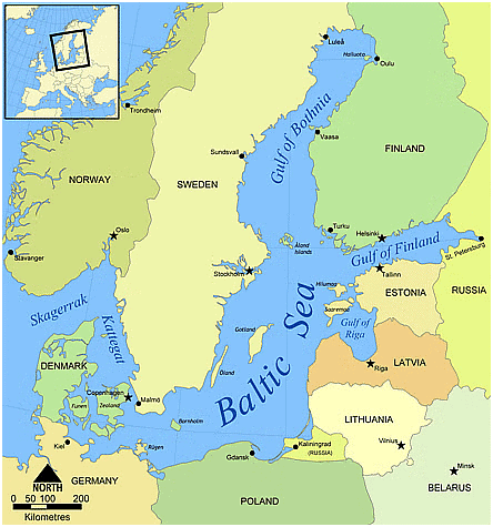
Context
Russia blamed Kyiv for attack on gas terminal at Baltic Sea port.
About
- The Baltic Sea is an arm of the North Atlantic Ocean. It is bound by the Scandinavian Peninsula, the mainland of Northern Europe, Eastern Europe and Central Europe, and the Danish islands.
- Surrounded by countries: Denmark, Germany, Poland, Lithuania, Latvia, Estonia, Russia, Finland and Sweden.
- It is extending from the Danish straits to the Gulf of Finland.
- It is connected to the North Sea through the Danish straits and the Kattegat, and it connects to the White Sea through the Baltic Canal.
- It is connected to St. Petersburg by the Gulf of Finland. The Gulf of Riga is located between Estonia and Latvia.
- The Baltic Sea is characterized by low salinity compared to ocean water. It is a brackish sea, meaning it has a mixture of saltwater from the North Sea and freshwater from various rivers.
- Islands: It has numerous islands, both large and small. Some of the notable ones include Gotland and Öland (Sweden), Saaremaa and Hiiumaa (Estonia), and Rügen (Germany).
|
969 docs|678 tests
|


shortcuts and tricks
,MCQs
,Geography: January 2024 Current Affairs | Current Affairs: Daily
,Previous Year Questions with Solutions
,Sample Paper
,Free
,video lectures
,Extra Questions
,Semester Notes
,ppt
,Exam
,Viva Questions
,study material
,Important questions
,Objective type Questions
,Weekly & Monthly - CLAT
,Weekly & Monthly - CLAT
,Weekly & Monthly - CLAT
,Geography: January 2024 Current Affairs | Current Affairs: Daily
,Geography: January 2024 Current Affairs | Current Affairs: Daily
,practice quizzes
,Summary
,past year papers
,mock tests for examination
;


Geography: January 2024 Current Affairs Free PDF Download
Importance of Geography: January 2024 Current Affairs
Geography: January 2024 Current Affairs Notes
Geography: January 2024 Current Affairs CLAT Questions
Study Geography: January 2024 Current Affairs on the App
|
© EduRev
|
Education Revolution
|


|


