Detailed Chapter Notes - Climate


In the last two chapters, you learned about the physical features and rivers of India-both are important parts of the natural environment. Now, it's time to explore the third major element: atmospheric conditions, or simply, the climate.
Have you ever wondered:
- Why do we wear warm clothes in December?
- Why does it get extremely hot in May?
- Why do we get heavy rains during June and July?
The answers lie in understanding India's climate.
What is Climate?
Climate means the average weather conditions of a place over a long period (usually more than 30 years). Weather, on the other hand, is the condition of the atmosphere at a particular moment. Both include elements like temperature, wind, humidity, rainfall, and atmospheric pressure.
You may have noticed that the weather can change within a single day. However, over weeks and months, we see patterns-for example, some months are hot and dry, others are cool and wet. Based on these patterns, the year is divided into different seasons such as summer, winter, and rainy season.
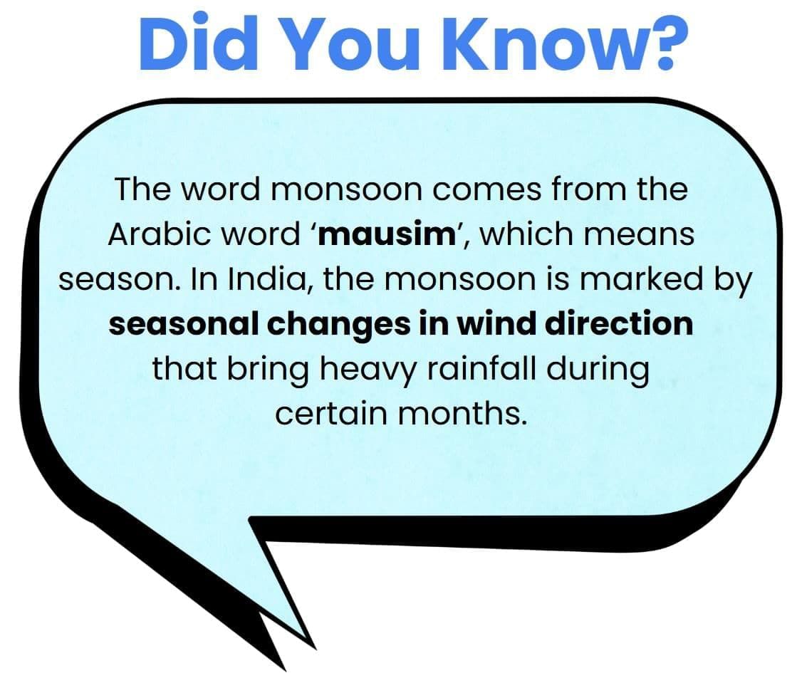
The world is divided into various climatic zones. But do you know what kind of climate India has? It is known as the monsoon type of climate.
Even though there's a general pattern to the Indian climate, there are clear regional differences:
- Temperature variations: In summer, it can be 50°C in Rajasthan and only 20°C in Kashmir. In winter, Drass (J&K) can drop to -45°C, while Thiruvananthapuram stays around 22°C.
- Rainfall differences: Rainfall is not the same everywhere. While Meghalaya receives over 400 cm of rainfall, Ladakh and Western Rajasthan get less than 10 cm. Most places get rain between June and September, but Tamil Nadu receives most of its rain during October and November.
Generally, coastal areas have mild temperature changes, while inland areas have more extreme seasonal differences. Rainfall usually decreases from east to west in the Northern Plains.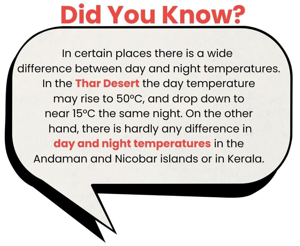
These climate differences influence how people live-from the clothes they wear to the food they eat and the houses they build.
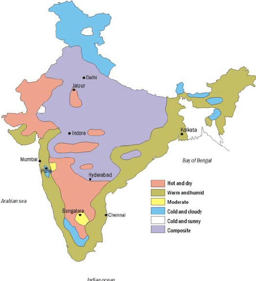 Different Climatic Zones in India
Try yourself: Most parts of India receive rainfall during which of the following months?
Climatic Controls
The climate of any place on Earth is influenced by several key natural factors, known as climatic controls. There are six major controls that work together to shape the temperature, rainfall, and overall weather pattern of a region:
- Latitude: The Earth is curved, so sunlight does not reach all parts equally. Places near the equator get more direct sunlight and are usually warmer. As you move towards the poles, the sunlight is less intense, making those areas cooler.
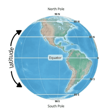 Latitudes
 - Altitude (Height above sea level): As we go higher above the Earth's surface (like climbing a mountain), the air becomes thinner and cooler. This is why hills and mountains are cooler than the plains, especially in summer.
- Pressure and Wind System: The movement of air pressure and wind patterns depends on the latitude and altitude of a place. These wind systems affect both temperature and rainfall in different regions.
- Distance from the Sea (Continentality): Places close to the sea have more moderate temperatures, meaning they don't get too hot or too cold. However, places that are far from the sea experience extreme weather-very hot summers and very cold winters. This effect is called continentality.
- Ocean Currents: The movement of warm or cold ocean water near the coast also affects the climate. For example, if warm ocean currents flow near a coastal area, they raise the temperature, while cold currents lower it-especially when winds blow from the sea to the land.
- Relief (Landforms like mountains): Mountains can block winds and affect rainfall. For example, if rain-bearing winds hit a mountain, they rise and cool, causing rainfall on one side (the windward side). The other side (called the leeward side) receives very little rain and stays dry.
Factors Affecting India's Climate
Latitude
The Tropic of Cancer runs through the middle of India-from the Rann of Kutch in the west to Mizoram in the east. This divides the country into two parts:
- The southern part lies in the tropical zone, which is generally hot and humid.
- The northern part lies in the subtropical zone, where temperatures are a bit cooler.
So, India has both tropical and subtropical climate features because of its location.
Altitude (Height above sea level)
India has the Himalayan mountains in the north with an average height of about 6,000 metres, and low-lying coastal areas with elevations of only around 30 metres.
The Himalayas play an important role in controlling India's climate:
- They block cold winds from Central Asia during winter.
- As a result, India has milder winters compared to other places at the same latitude, like Central Asia.
Pressure and Winds
India's climate and weather are mainly controlled by three important atmospheric factors:
- Pressure and surface winds
- Air movement in the upper atmosphere
- Western cyclones and tropical storms
Regular Wind Pattern:
India lies in a region where northeast winds blow. These winds start from a high-pressure area in the northern hemisphere and move towards the equator, where there is low pressure. Because of the Coriolis effect (caused by Earth's rotation), these winds bend to the right.
These winds come from land and carry very little moisture, so they don't bring much rain. Based on this, India should have been a dry land-but it is not. Why?
Unique Pressure and Wind Conditions in India:
- In Winter:
A high-pressure area forms north of the Himalayas. From here, cold and dry winds blow towards the south, where the pressure is low (over the oceans). These winds don't bring rain. - In Summer:
A low-pressure area develops over northwest India and central Asia due to intense heat. At the same time, a high-pressure area exists over the southern Indian Ocean. This leads to a complete change in wind direction:
a) Winds blow from the Indian Ocean towards India.
b) They move in a southeasterly direction, cross the equator, and turn southwest due to the Coriolis effect.
c) These are called the Southwest Monsoon Winds.
These monsoon winds blow over warm oceans, collect a lot of moisture, and bring heavy rainfall to most parts of India.
The Seasons
India has a monsoon-type climate, which means the weather changes clearly from one season to another. These changes are more noticeable in the inland areas of the country. In coastal regions, the temperature stays more or less the same, but the amount of rainfall can vary.
Have you ever thought about how many seasons your region experiences?
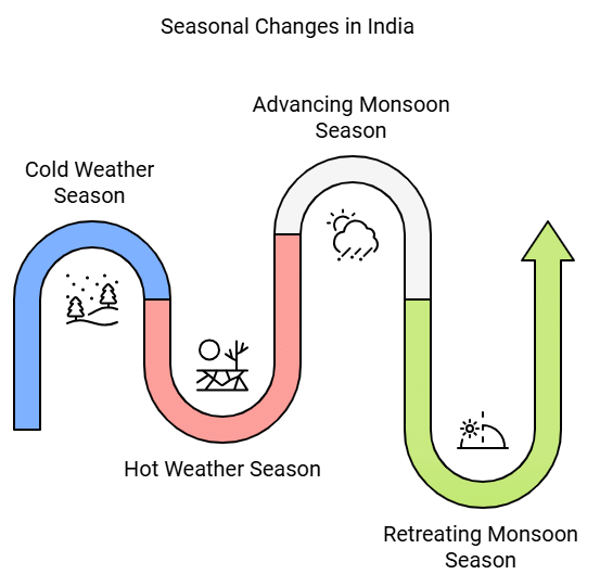
In general, India goes through four main seasons:
- Cold Weather Season (Winter)
- Hot Weather Season (Summer)
- Advancing Monsoon (Rainy Season)
- Retreating Monsoon (Post-Monsoon Season)
These seasons may feel a bit different in different parts of the country, but this is the overall seasonal pattern across India.
Try yourself: Which one of the following causes rainfall during winters in north-western part of India?
The Cold Weather Season (Winter)
- The cold weather season in northern India lasts from mid-November to February, with December and January being the coldest months.
- Temperatures drop from south to north in India. For example, Chennai on the eastern coast has an average temperature of 24-25°C, while the northern plains see temperatures between 10°C and 15°C. Days tend to be warm, but nights get quite cold during this season.
- Frost is common in the north, and the higher Himalayan slopes see snowfall.
- During this time, the northeast trade winds dominate the country, blowing from land to sea, leading to a mostly dry season. However, some rainfall occurs on the Tamil Nadu coast as these winds blow from sea to land.
- In northern India, there is a slight variation in rainfall patterns during winter.
- A notable aspect of the cold weather season in the northern plains is the arrival of cyclonic disturbances from the west and northwest. These low-pressure systems come from the Mediterranean Sea and western Asia, moving into India and bringing essential winter rains to the plains and snowfall to the mountains.
- Though the total winter rainfall, locally called 'mahawat', is small, it is very important for the growth of 'rabi' crops.
- The peninsular region does not experience a distinct cold season, as there is hardly any noticeable change in temperature during winter due to the influence of the sea.
The Hot Weather Season (Summer)
From March to May, most parts of India experience the hot weather season. This happens because the sun appears to move northward, and the heat belt (the hottest part of Earth) also shifts north. This leads to a rise in temperatures across the country.
- In March, the Deccan Plateau records high temperatures of around 38°C.
- In April, places like Gujarat and Madhya Pradesh see temperatures reaching 42°C.
- In May, the temperature in northwestern India often reaches 45°C or more.
- Peninsular India (southern part) stays a bit cooler because of the cooling effect of the nearby seas and oceans.
As summer progresses:
- Temperatures rise and air pressure drops in northern India.
- By late May, a low-pressure area forms from the Thar Desert in the northwest to Patna and the Chotanagpur Plateau in the east. This leads to air circulation in the region.
Special Weather Features of Summer:
- Loo: These are hot, dry, and strong winds that blow during the day, especially in north and northwest India. They can be very dangerous and sometimes even life-threatening.
- Dust Storms: Common in May, these storms bring cool breezes and light rain, giving temporary relief from the heat.
- Local Thunderstorms: These sudden and violent storms bring heavy rain, strong winds, and sometimes hail. In West Bengal, they are known as 'Kaal Baisakhi'.
- Mango Showers: Towards the end of summer, states like Kerala and Karnataka get early rain showers. These are called pre-monsoon showers and help in ripening mangoes, so they are also called 'mango showers'.
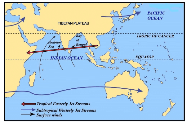 Atmospheric Conditions over the Indian Subcontinent in the Month of June
Try yourself: What causes rainfall in West Bengal during the hot weather season?
Advancing Monsoon (The Rainy Season)
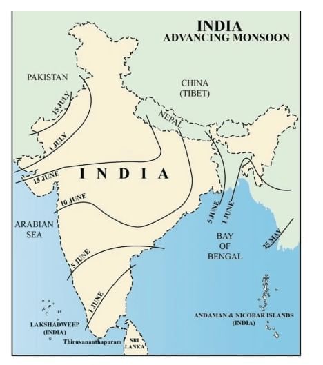
By the beginning of June, the low-pressure area over the northern plains becomes stronger. This low pressure pulls in the southeast trade winds from the southern hemisphere. These winds start from the warm oceans in the south, cross the equator, and turn into southwest monsoon winds as they enter India.Since these winds travel over the warm oceans, they carry a lot of moisture and bring heavy rainfall to the Indian subcontinent. They are strong winds, blowing at about 30 km/h. Except for the northwestern desert areas, these monsoon winds cover almost the entire country within a month.
Where Does It Rain the Most?
- The western side of the Western Ghats (mountains along the west coast) gets very heavy rain-more than 250 cm.
- The Deccan Plateau and Madhya Pradesh, though in the rain shadow area, still receive some rainfall.
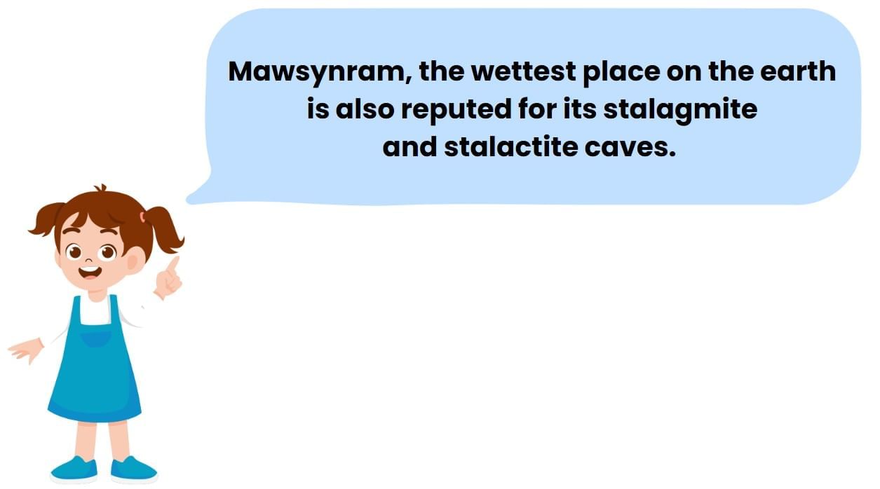
- The northeastern part of India gets the maximum rainfall, especially Mawsynram in Meghalaya, which receives the highest average rainfall in the world.
- In the Ganga Valley, rainfall decreases from east to west.
- Rajasthan and Gujarat get very little rain.
Breaks in the Monsoon
The monsoon doesn't bring rain every day. It often comes in spells-there are a few wet days, followed by dry days. These are called 'breaks' in the monsoon.
This happens because of the movement of a low-pressure area called the monsoon trough. When this trough is over the plains, these areas get good rain. But when it moves north towards the Himalayas, the plains become dry, and heavy rains occur in the hills, sometimes causing floods.
Tropical Depressions and Uncertainty
- The amount and duration of rainfall also depends on tropical depressions-low-pressure systems that form over the Bay of Bengal and move inland.
- These depressions follow the monsoon trough and play a key role in how much rain falls in different parts of India.
Why Is the Monsoon Unpredictable?
- The monsoon is not regular. It can bring floods in one region and drought in another.
- Its arrival and retreat are often delayed or early.
- Because of this uncertainty, it affects the farming calendar and creates difficulties for millions of farmers across the country.
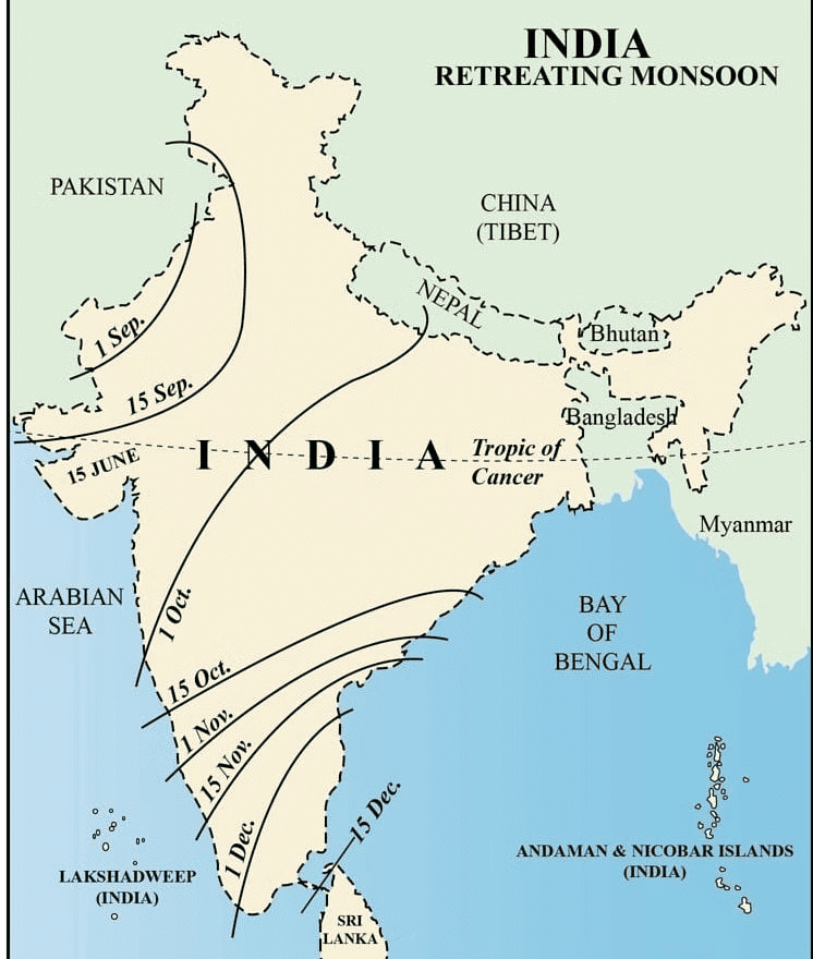
Retreating/Post Monsoons (The Transition Season)
During October and November, the sun starts moving southward, and the low-pressure area over the northern plains becomes weaker. It is slowly replaced by a high-pressure area, and the southwest monsoon winds begin to retreat (move back).
By early October, the monsoon completely withdraws from the Northern Plains.
Changing Weather in October-November
This time is a transition between the rainy season and the winter season.
- The weather becomes clearer, and the sky is mostly blue.
- Daytime temperatures are still high, but the nights become cooler and more pleasant.
- The land is still moist from the rains, and because of the mix of heat and humidity, the weather feels hot and uncomfortable during the day. This is called 'October Heat'.
- By late October, temperatures in northern India start to drop quickly.
Cyclones and Rainfall
In early November, the low-pressure area over northwest India shifts to the Bay of Bengal. This leads to the formation of cyclonic storms over the Andaman Sea.
- These cyclones usually move towards the eastern coast of India and bring heavy rainfall.
- They can be very dangerous and often cause serious damage in densely populated coastal areas.
- The deltas of the Godavari, Krishna, and Kaveri rivers are especially affected.
- Sometimes, the coasts of Odisha, West Bengal, and even Bangladesh are hit.
- The Coromandel Coast (along Tamil Nadu) gets most of its rainfall during this season, mainly from these cyclonic storms.

Distribution of Rainfall
Some parts of India get a lot of rainfall, while others get very little.
- The western coast (like Kerala and coastal Karnataka) and the northeastern states (like Meghalaya and Assam) get more than 400 cm of rain every year.
- But areas like western Rajasthan, parts of Gujarat, Haryana, and Punjab get less than 60 cm of rain annually.
- Central parts of the Deccan Plateau and areas east of the Sahyadri Hills also get very little rainfall. Do you know why? These places lie in the rain shadow region, so rain clouds do not reach them easily.
- Another dry area is Leh in Jammu and Kashmir, where rainfall is also very low.
- Most other parts of India receive moderate rainfall. Snowfall mostly happens in the Himalayan region only.
- Because monsoons are not regular, the amount of rain changes from year to year.
- In places where rainfall is usually low (like parts of Rajasthan, Gujarat, and the back side of the Western Ghats), this change is very unpredictable.
- As a result:
- Areas with too much rain may face floods.
- Areas with very little rain may suffer from droughts.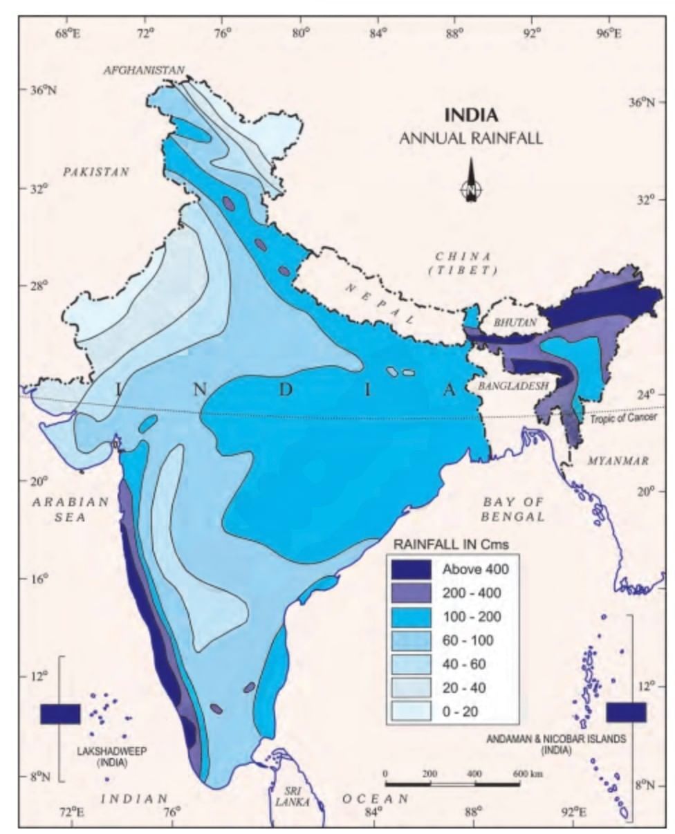 Annual Rainfall
Monsoon as a Unifying Bond
The Himalayas protect India from the icy cold winds of Central Asia, so northern India stays warmer than other places at the same distance from the equator. The Peninsular Plateau, surrounded by the sea on three sides, has moderate (not too hot or cold) temperatures.
Even with these factors, there are big temperature differences in different regions. Still, the monsoon brings unity to the whole country.
The changing monsoon winds and their weather create a regular cycle of seasons. Though the rains may come late, early, or unevenly, this is a special feature of Indian monsoons.
Everything in India - from the landscape, plants, and animals to farming, festivals, and daily life - depends on the monsoon. Every year, people all over India wait for the rains to begin farming.
The monsoon winds give water that helps start agriculture, and the rivers that carry this water help connect different parts of the country, just like one big family.
Advancing Monsoon (The Rainy Season)
Formation and Movement
- By early June, an intense low-pressure area forms over the northern plains of India.
- This attracts southeast trade winds from the southern hemisphere.
- These winds cross the equator and turn into southwest monsoon winds.
- As they pass over warm oceans, they collect a lot of moisture.
- These winds are strong, blowing at about 30 km/h.
- They cover most of India within a month, except the far northwest.
 The Onset of South West Monsoon Rainfall During Southwest Monsoon
- Brings a complete change in weather across India.
- Western Ghats receive very heavy rainfall (more than 250 cm) on the wind-facing side.
- Deccan Plateau and Madhya Pradesh also get some rain, even though they lie in rain shadow areas.
- The northeastern region gets the most rainfall in the country.
- Mawsynram in the Khasi Hills receives the highest average rainfall in the world.
- Rainfall in the Ganga valley decreases from east to west.
- Rajasthan and parts of Gujarat receive very little rain.
Breaks in Monsoon
- The monsoon has wet and dry spells, called monsoon breaks.
- Rain doesn't fall every day-it comes in intervals.
- These breaks are caused by the movement of the monsoon trough (a low-pressure zone).
- When the trough is over the plains, those areas get good rain.
- When it shifts closer to the Himalayas, the plains stay dry and mountain areas get heavy rain. - Heavy rains in mountain areas can cause floods in the plains.
Role of Tropical Depressions
- Tropical depressions form in the Bay of Bengal and move along the monsoon trough.
- These systems affect the amount and duration of rainfall.
- They can cause floods in some areas and droughts in others.
Uncertainty of Monsoon
- The monsoon is unpredictable and irregular in timing, strength and duration.
- Causes floods in one region and drought in another.
- Its irregular pattern often disrupts the farming schedule of millions of Indian farmers.
Retreating/Post-Monsoons (The Transition Season)
Monsoon Withdrawal
- In October-November, as the sun shifts southward, the monsoon trough weakens over the northern plains, leading to the development of a high-pressure system.
- The southwest monsoon winds gradually diminish, causing the monsoon to withdraw from the Northern Plains.
- October and November signify a transition from the rainy season to drier winter conditions, marked by clear skies and a shift to drier weather patterns.
 Retreating Monsoon
October Heat
- During October, India experiences high temperatures and humidity, known as the 'October heat' phenomenon, which can make the weather oppressively hot.
Cyclonic Activity
- In late October, temperatures in northern India begin to decrease rapidly as low-pressure conditions move from northwestern India towards the Bay of Bengal.
- By early November, low-pressure conditions in the Bay of Bengal lead to the formation of cyclonic depressions over the Andaman Sea.
- These cyclones often cross the eastern coasts of India, bringing heavy rain and causing significant damage.
Impact of Cyclones
- The deltas of the Godavari, Krishna, and Kaveri rivers, as well as the coastal areas of Odisha, West Bengal, and Bangladesh, are frequently affected by cyclones, leading to substantial destruction of life and property.
- The Coromandel Coast relies significantly on depressions and cyclones for its rainfall, which plays a crucial role in shaping the region's weather patterns.
Distribution of Rainfall
High Rainfall Areas
- The western coast and northeastern India receive more than 400 cm of rainfall annually.
Low Rainfall Areas
- Western Rajasthan, parts of Gujarat, Haryana, and Punjab experience less than 60 cm of rainfall each year.
- The interior of the Deccan Plateau and the eastern side of the Sahyadris also receive low precipitation.
- Leh in Jammu and Kashmir is another area with very low rainfall.
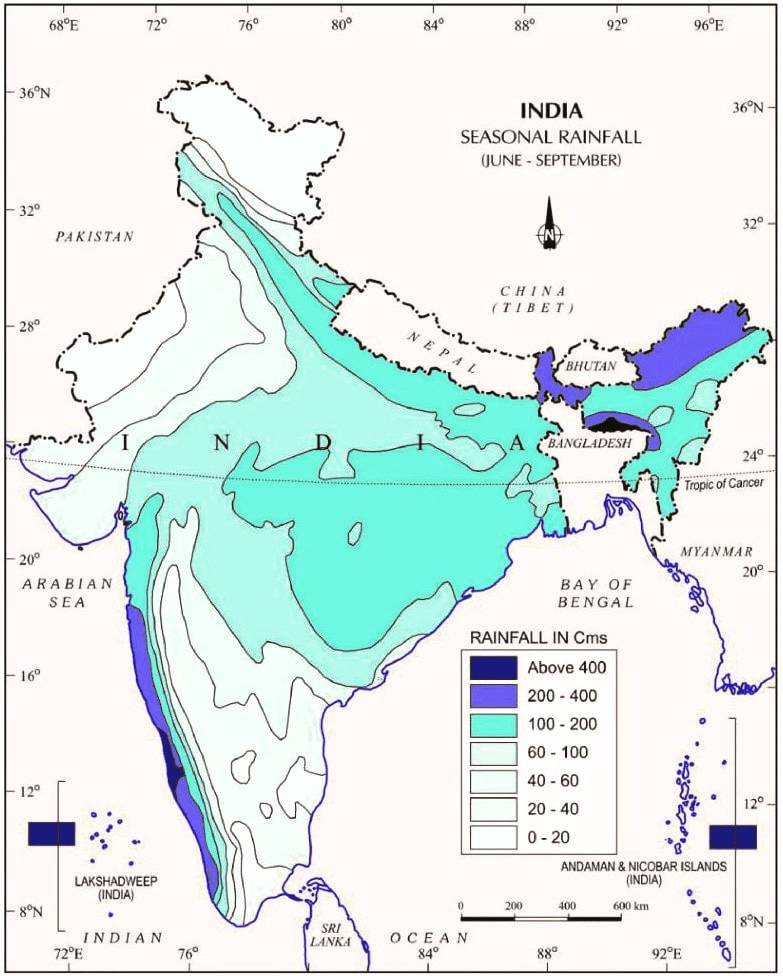 Seasonal Rainfall
Low Rainfall Areas
- Western Rajasthan, parts of Gujarat, Haryana, and Punjab experience less than 60 cm of rainfall each year.
- The interior of the Deccan Plateau and the eastern side of the Sahyadris also receive low precipitation.
- Leh in Jammu and Kashmir is another area with very low rainfall.
Moderate Rainfall Areas
- Most of the rest of the country receives moderate rainfall.
- Snowfall is generally limited to the Himalayan region.
Rainfall Variability and Its Impacts
- Annual rainfall varies significantly across the country due to the nature of the monsoons.
- High rainfall regions are prone to flooding, while low rainfall areas are susceptible to drought conditions.
Monsoon As A Unifying Bond
- The Himalayas block the cold winds from Central Asia, which helps northern India stay warmer than other places at the same latitude.
- The Peninsular Plateau, surrounded by the sea on three sides, has moderate temperatures due to the influence of the sea.
- Even with these natural effects, there are still large differences in temperature in different parts of the country.

- The monsoon winds bring a shared weather pattern to the whole country.
- These winds change with the seasons and create a regular cycle of different weather conditions.
- Though the rainfall is not always regular or evenly spread, this variation is a common feature of the monsoons.
- The monsoon plays an important role in shaping India's land, plants, animals, farming schedule, and festivals.
- People across India eagerly wait every year for the monsoon to arrive.
- The rain brought by the monsoon helps start farming activities all over the country.
- The rivers that carry this rainwater connect various regions and support agriculture across India.
Key Terms
- Weather vs. Climate: Weather describes the short-term atmospheric conditions in a specific place at a specific time, while climate refers to the average long-term weather patterns over a significant period, typically 30 years. This distinction helps in understanding daily weather forecasts versus long-term climate patterns.
- Temperature Variations: The significant differences in temperature across various regions due to factors like geographical location, altitude, and proximity to water bodies. For example, Rajasthan experiences extreme heat, while Pahalgam in Jammu and Kashmir has moderate summer temperatures.
- Precipitation Variations: Differences in the amount and type of precipitation (rain, snow, sleet) that different regions receive based on their climate zones. High variability affects agriculture, water resources, and overall weather patterns.
- Climatic Controls: Factors that influence a region's climate, including latitude, altitude, pressure and wind systems, distance from the sea, ocean currents, and relief features. Each of these factors contributes differently to shaping the local climate by affecting temperature, humidity, and precipitation.
- Latitude and Climate: The position of a place on the Earth's surface in relation to the equator (latitude) affects its solar radiation intake, influencing its overall climate. Tropical regions near the equator receive more sunlight and have warmer climates compared to polar regions near the poles.
- Altitude's Impact on Climate: Higher altitudes are characterized by thinner air, which can hold less heat, leading to cooler temperatures. This is why mountainous regions typically have colder climates than areas at sea level.
- Pressure and Wind Systems: The movement and interaction of different air pressure systems across the Earth influence weather patterns and climatic conditions. For example, high-pressure systems are generally associated with stable and dry weather, while low-pressure systems can lead to storms and rainfall.
- Continentality (Distance from the Sea): The effect of an area's distance from the sea on its climate, where areas closer to the sea have milder climates and smaller temperature fluctuations compared to inland areas.
- Ocean Currents: Streams of seawater moved by various global wind systems that can significantly influence coastal climates by carrying warm or cold water across different parts of the globe.
- Relief Features: Geographic features like mountains that affect climate by blocking wind and precipitation, creating varied weather patterns on their windward and leeward sides.
- Monsoon: A seasonal wind system that dramatically influences the climate of regions like India by bringing heavy rains during the summer months. The monsoon is crucial for agriculture but also causes significant weather-related challenges like flooding.
- Cyclonic Depressions: Low-pressure areas in the atmosphere that can lead to severe weather conditions, including storms and heavy rainfall, particularly impactful in shaping the seasonal weather patterns in regions like India.
FAQs on Detailed Chapter Notes - Climate
| 1. What is climate and how is it different from weather for Class 9 SST? |  |
| 2. What are the main factors that affect climate in different regions? | |
| 3. How do pressure systems and winds control the climate of India? | |
| 4. What are the different climate zones and their characteristics for exam preparation? | |
| 5. Why is the Coriolis effect important in understanding global climate patterns? | |


