


All Exams >
Class 9 >
Social Studies (SST) Class 9 >
All Questions
All questions of Drainage for Class 9 Exam
Which one of the following lakes differs from the rest in the group?- a)Dal Lake
- b)Nainital Lake
- c)The Guru Gobind Sagar Lake
- d)Bhimtal Lake
Correct answer is option 'C'. Can you explain this answer?
Which one of the following lakes differs from the rest in the group?
a)
Dal Lake
b)
Nainital Lake
c)
The Guru Gobind Sagar Lake
d)
Bhimtal Lake
|
|
Geetika Chopra answered |
The Guru Gobind Sagar Lake differs from the rest of the lakes in the group.
Reasons:
Location:
- The Guru Gobind Sagar Lake is located in the state of Himachal Pradesh, while the other lakes are located in Uttarakhand and Jammu and Kashmir.
Origin:
- The Guru Gobind Sagar Lake is a man-made reservoir, created by the Bhakra Dam on the Sutlej River. In contrast, the other lakes are natural or semi-natural.
Purpose:
- The Guru Gobind Sagar Lake was created primarily for hydroelectric power generation, irrigation, and drinking water supply. The other lakes do not have such a specific purpose.
Size:
- The Guru Gobind Sagar Lake is much larger than the other lakes, with a surface area of about 170 square kilometers. In comparison, Dal Lake has a surface area of about 18 square kilometers, Nainital Lake has a surface area of about 1.5 square kilometers, and Bhimtal Lake has a surface area of about 1.2 square kilometers.
Tourism:
- While the other lakes are popular tourist destinations, the Guru Gobind Sagar Lake is not as well-known as a tourist spot. It is mainly visited by people interested in water sports and fishing.
In conclusion, the Guru Gobind Sagar Lake differs from the rest of the lakes in the group due to its location, origin, purpose, size, and popularity as a tourist destination.

Most of the Peninsular rivers are perennial.
- a)False
- b)True
Correct answer is option 'A'. Can you explain this answer?
Most of the Peninsular rivers are perennial.
a)
False
b)
True
|
|
Aravind Jain answered |
False
Explanation:
Perennial rivers are those rivers which flow throughout the year. Most of the Peninsular rivers are not perennial in nature. These rivers depend on rainfall for their flow and hence, they dry up during summers. Some of the major Peninsular rivers such as Godavari, Krishna, Cauvery, etc. have a seasonal flow and are not perennial. However, some of the Peninsular rivers such as Narmada and Tapti have a perennial flow as they originate from the mountains and are not solely dependent on rainfall. Hence, the statement that most of the Peninsular rivers are perennial is false.
Which of the following is a famous lake of Srinagar in Kashmir?- a)Sambhar
- b)Bhimtal
- c)Chilika
- d)Dal
Correct answer is option 'D'. Can you explain this answer?
Which of the following is a famous lake of Srinagar in Kashmir?
a)
Sambhar
b)
Bhimtal
c)
Chilika
d)
Dal
|
|
Amit Sharma answered |
D is the correct option.Dal is a lake in Srinagar, the summer capital of Jammu and Kashmir, India. It is an urban lake, which is the second largest in the union territory of Jammu and Kashmir. It is integral to tourism and recreation in Kashmir and is named the "Lake of Flowers", "Jewel in the crown of Kashmir" or "Srinagar's Jewel".
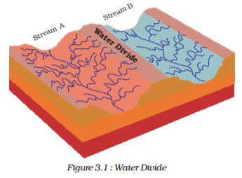
The area drained by a single river system is called a – - a)Water shed
- b)Drainage basin
- c)Water divide
- d)Drainage Line
Correct answer is option 'B'. Can you explain this answer?
The area drained by a single river system is called a –
a)
Water shed
b)
Drainage basin
c)
Water divide
d)
Drainage Line
|
|
Ravi Verma answered |
The term drainage describes the river system of an area. Look at the physical map. You will notice that small streams flowing from different directions come together to form the main river, which ultimately drains into a large water body such as a lake or a sea or an ocean. The area drained by a single river system is called a drainage basin. A closer observation on a map will indicate that any elevated area, such as a mountain or an upland, separates two drainage basins. Such an upland is known as a water divide (Figure 3.1).
Which type of lakes contain water only during the rainy season?- a)Oxbow lakes
- b)Lagoons
- c)Lakes in basins of inland drainage
- d)Glacial lakes
Correct answer is option 'C'. Can you explain this answer?
Which type of lakes contain water only during the rainy season?
a)
Oxbow lakes
b)
Lagoons
c)
Lakes in basins of inland drainage
d)
Glacial lakes
|
|
Pooja Shah answered |
India has many lakes. These differ from each other in size, and other characteristics. Most lakes are permanent; some contain water only during the rainy season, like the lakes in the basins of inland drainage of semi-arid region.
The total length of River Ganga drainage basin is- a)2500 km
- b)2900 km
- c)2700 km
- d)None of these
Correct answer is option 'A'. Can you explain this answer?
The total length of River Ganga drainage basin is
a)
2500 km
b)
2900 km
c)
2700 km
d)
None of these
|
|
Shail Kapoor answered |
Length of River Ganga Drainage Basin
The total length of River Ganga drainage basin is 2500 km.
Explanation
The River Ganga is one of the largest rivers in India and has a significant impact on the country's culture, economy, and environment. The river flows through several states in northern India, including Uttarakhand, Uttar Pradesh, Bihar, Jharkhand, and West Bengal. The Ganga basin is also one of the most densely populated regions in the world.
The River Ganga drainage basin is the area of land drained by the river and its tributaries. The length of the drainage basin is measured from the source of the river in the Himalayas to the point where it meets the Bay of Bengal. The total length of the River Ganga drainage basin is approximately 2,500 km.
The River Ganga is considered holy by Hindus and is a significant pilgrimage site. It is also an essential source of water for agriculture, industry, and domestic use. However, the river is facing several challenges, including pollution, climate change, and overuse. The Indian government has launched several initiatives to clean up the river and prevent further degradation.
Conclusion
In conclusion, the total length of the River Ganga drainage basin is 2,500 km. The river is an essential resource for India and its people, but it is also facing significant challenges. It is crucial to take steps to protect and preserve the river for future generations.
Where does the river Indus rise? - a)Tibet
- b)Himalayan
- c)Kailash
- d)All the above
Correct answer is option 'A'. Can you explain this answer?
Where does the river Indus rise?
a)
Tibet
b)
Himalayan
c)
Kailash
d)
All the above

|
Yash Choudhary answered |
The river Indus originates in Tibet; near Lake Mansarowar. It enters India in the Ladakh district of Jammu & Kashmir.
The river Narmada has its source at- a)Amarkantak
- b)Vindhya range
- c)Satpura range
- d)All the above
Correct answer is option 'A'. Can you explain this answer?
The river Narmada has its source at
a)
Amarkantak
b)
Vindhya range
c)
Satpura range
d)
All the above
|
|
Poulomi Chavan answered |
**The source of the river Narmada is Amarkantak.**
The river Narmada, one of the major rivers in India, originates from the Amarkantak plateau. It is located in the Maikal Mountains, which is part of the Vindhya Range. Amarkantak is a pilgrimage town situated at an altitude of around 1065 meters in the Anuppur district of Madhya Pradesh.
**Amarkantak**:
- Amarkantak is considered a sacred place by Hindus as it is believed to be the meeting point of the Vindhya Range and the Satpura Range, which are two important mountain ranges in central India.
- It is believed that the Narmada River emerges as a result of the union of two small streams, namely, the Sonbhadra and the Johila, at the origin point in Amarkantak.
- The Sonbhadra stream originates from the east while the Johila stream originates from the west. They converge at the Amarkantak plateau to form the Narmada River.
**Vindhya Range**:
- The Vindhya Range is a range of hills and mountains that runs parallel to the Narmada River in central India.
- It extends from eastern Gujarat through Madhya Pradesh and into southeastern Uttar Pradesh.
- The Vindhya Range acts as a watershed between the rivers flowing into the Arabian Sea and those flowing into the Bay of Bengal.
- It is a prominent feature in the landscape of central India and is known for its rich biodiversity and scenic beauty.
**Satpura Range**:
- The Satpura Range is another important mountain range in central India.
- It runs parallel to the Vindhya Range and forms the southern boundary of the Narmada River basin.
- The Satpura Range is known for its dense forests, wildlife sanctuaries, and hill stations.
- Several rivers, including the Tapti and the Narmada, originate from this range.
In conclusion, the river Narmada has its source at Amarkantak, which is located in the Maikal Mountains of the Vindhya Range. The belief that the Narmada River is formed by the union of the Sonbhadra and Johila streams at Amarkantak makes it a significant pilgrimage site for Hindus.
The Dibang and Lohit are the tributaries of river ____________- a)Narmada
- b)Brahmaputra
- c)Ganga
- d)Yamuna
Correct answer is option 'B'. Can you explain this answer?
The Dibang and Lohit are the tributaries of river ____________
a)
Narmada
b)
Brahmaputra
c)
Ganga
d)
Yamuna
|
|
Meenal Menon answered |
The correct answer is option 'B', Brahmaputra.
The Dibang and Lohit rivers are two major tributaries of the Brahmaputra River in India. They are both located in the state of Arunachal Pradesh, which is in the northeastern part of India. Let's explore more about these rivers and their significance.
1. The Brahmaputra River:
- The Brahmaputra is one of the major rivers in Asia and is known as the lifeline of northeastern India.
- It originates from the Angsi Glacier in the Himalayas and flows through Tibet, India, and Bangladesh.
- In India, it enters through the state of Arunachal Pradesh and flows through Assam before entering Bangladesh and eventually merging with the Ganges River.
- The Brahmaputra River is known for its massive volume of water and plays a crucial role in the region's economy and transportation.
2. The Dibang River:
- The Dibang River is the largest tributary of the Brahmaputra River.
- It originates from the northern slopes of the Great Himalayas in Arunachal Pradesh.
- The river flows through the Dibang Valley and eventually joins the Brahmaputra near the town of Sadiya in Assam.
- The Dibang River is known for its scenic beauty and is surrounded by dense forests and snow-clad mountains.
3. The Lohit River:
- The Lohit River is another important tributary of the Brahmaputra River.
- It originates in eastern Tibet and enters India through Arunachal Pradesh.
- The river flows through the Mishmi Hills and joins the Brahmaputra near the town of Tezu in Arunachal Pradesh.
- The Lohit River is known for its turbulent waters and is a popular destination for rafting and adventure sports.
4. Significance:
- The Dibang and Lohit rivers, along with other tributaries, contribute significantly to the water flow of the Brahmaputra River.
- These rivers play a vital role in the irrigation, agriculture, and fisheries of the region.
- The Brahmaputra River and its tributaries are also a source of transportation and are used for both commercial and leisure purposes.
- The rivers and their surrounding areas are ecologically diverse, supporting a wide range of flora and fauna.
In conclusion, the Dibang and Lohit rivers are important tributaries of the Brahmaputra River. They originate in Arunachal Pradesh and contribute to the overall water flow and ecological significance of the region.
Name the saltwater lake of Rajasthan.- a)Chilika
- b)Sambhar
- c)Pulicat
- d)Kallery
Correct answer is option 'B'. Can you explain this answer?
Name the saltwater lake of Rajasthan.
a)
Chilika
b)
Sambhar
c)
Pulicat
d)
Kallery
|
|
Maanvi Desai answered |
Saltwater Lake of Rajasthan: Sambhar
Sambhar is the largest saltwater lake in India, located in the state of Rajasthan. It is a part of the Sambhar Lake Town, which is situated around 80 km southwest of Jaipur. The lake is spread over an area of 190 to 230 square kilometers, depending on the water level.
Formation of Sambhar Lake
Sambhar Lake was formed approximately 5,000 years ago when a river named 'Saraswati' changed its course due to tectonic activities. The lake is fed by several small streams and rivers, but it has no outlet. The water in the lake evaporates, leaving behind a high concentration of salt, which is harvested by locals.
Ecology and Wildlife
Sambhar Lake is a significant wetland ecosystem of Rajasthan and is a critical habitat for many migratory birds. It is listed as a Ramsar site, which is a wetland of international importance. The lake is home to a wide variety of birds such as flamingoes, pelicans, storks, and several species of ducks. The lake is also an essential feeding and breeding ground for many resident birds such as Indian cormorants, spoonbills, and painted storks.
Tourism
Sambhar Lake is a popular tourist destination in Rajasthan. The lake is surrounded by hills, and the view of the sunset from the lake is breathtaking. Several resorts and hotels are situated around the lake, which offers a comfortable stay to tourists. The lake is also an excellent spot for bird watching, and many tourists visit the lake to witness the migratory birds during winter.
Conclusion
Sambhar Lake is a unique ecosystem of Rajasthan and has significant ecological and economic importance. It is a must-visit destination for tourists who are interested in bird watching and wish to experience the beauty of nature.
Which of the following statements about the river Narmada is not correct?- a)It flows through a rift valley
- b)It flows through a gorge near Jabalpur
- c)It plunges over steep rocks at a Dhaudhar fall
- d)Its tributaries are the Tungabhadra and Musi
Correct answer is option 'D'. Can you explain this answer?
Which of the following statements about the river Narmada is not correct?
a)
It flows through a rift valley
b)
It flows through a gorge near Jabalpur
c)
It plunges over steep rocks at a Dhaudhar fall
d)
Its tributaries are the Tungabhadra and Musi
|
|
Kunal Sengupta answered |
About the River Narmada
The River Narmada is one of the most important rivers in India. It rises in the Amarkantak hills in Madhya Pradesh and flows westward for nearly 1,300 km before it empties into the Arabian Sea.
Incorrect Statement
d) Its tributaries are the Tungabhadra and Musi
Explanation
The statement that the tributaries of the River Narmada are the Tungabhadra and Musi is incorrect. The correct tributaries of the River Narmada are:
- The Banjar River
- The Sher River
- The Hiran River
- The Tawa River
- The Ganjal River
- The Kaveri River
- The Burhner River
- The Shakkar River
- The Dudhi River
Therefore, option D is the correct answer to this question.
Which of the following is an artificial lake located in Andhra Pradesh?
- a)Kolleru
- b)Nagarjuna Sagar
- c)Krishnaraja Sagar
- d)Vembanad
Correct answer is option 'B'. Can you explain this answer?
Which of the following is an artificial lake located in Andhra Pradesh?
a)
Kolleru
b)
Nagarjuna Sagar
c)
Krishnaraja Sagar
d)
Vembanad
|
|
Vikas Choudhury answered |
Kolleru Lake is one of the largest freshwater lakes in India located in the state of Andhra Pradesh and forms the largest shallow freshwater[ lake in Asia, 15 kilometers away from the city of Eluru. Kolleru is located between Krishna and Godavari deltas. Kolleru spans into two districts - Krishna and West Godavari. The lake is fed directly by water from the seasonal Budameru and Tammileru streams and is connected to the Krishna and Godavari irrigation systems by over 67 major and minor irrigation canals. This lake is a major tourist attraction.
Which of the following is not a tributary of river Krishna?- a)Tungabhadra
- b)Malaprabha
- c)Amravati
- d)Ghataprabha
Correct answer is option 'C'. Can you explain this answer?
Which of the following is not a tributary of river Krishna?
a)
Tungabhadra
b)
Malaprabha
c)
Amravati
d)
Ghataprabha

|
Binitha Sanjith answered |
Amravati is a tributary of Kaveri.So answer is C
Which one of the following rivers have Nagarjun Sagar Dam, a river valley project? - a)Kaveri
- b)Krishna
- c)Damodar
- d)Mahi
Correct answer is option 'B'. Can you explain this answer?
Which one of the following rivers have Nagarjun Sagar Dam, a river valley project?
a)
Kaveri
b)
Krishna
c)
Damodar
d)
Mahi
|
|
Rahul Desai answered |
Nagarjuna Sagar Dam is a masonry dam across the Krishna river at Nagarjuna Sagar which straddles the border between Guntur district, Andhra Pradesh and Nalgonda district, Telangana.
Which of the following lake is a lagoon in the coastal region of Orissa?- a)Bhimtal
- b)Barapani
- c)Chilika
- d)Hirakud
Correct answer is option 'C'. Can you explain this answer?
Which of the following lake is a lagoon in the coastal region of Orissa?
a)
Bhimtal
b)
Barapani
c)
Chilika
d)
Hirakud
|
|
Ræjû Bhæï answered |
Chilika Lake is a brackish water lagoon, spread over the Puri, Khurda and Ganjam districts of Odisha state on the east coast of India, at the mouth of the Daya River, flowing into the Bay of Bengal, covering an area of over 1,100 km.
The Wular Lake is in ____________- a)Jammu and Kashmir
- b)Rajasthan
- c)Goa
- d)Jharkhand
Correct answer is option 'A'. Can you explain this answer?
The Wular Lake is in ____________
a)
Jammu and Kashmir
b)
Rajasthan
c)
Goa
d)
Jharkhand
|
|
Ananya Sharma answered |
The Wular Lake is located in the state of Jammu and Kashmir in India. It is the largest freshwater lake in India and is located in the northern part of the state, in the district of Bandipora. The correct answer to your question is a) Jammu and Kashmir.
Which of the following is the description of the term drainage basin?
- a)The river system of an area
- b)The area drained by a single river system
- c)An upland that separates two drainage basins
- d)None of the above
Correct answer is option 'B'. Can you explain this answer?
Which of the following is the description of the term drainage basin?
a)
The river system of an area
b)
The area drained by a single river system
c)
An upland that separates two drainage basins
d)
None of the above
|
|
Saikat Iyer answered |
Definition of Drainage
Drainage refers to the network of rivers, streams, and other water bodies that collect and carry water from a particular area.
Description of the Term Drainage
Option 'B' is the correct answer. It describes the river system of an area. Drainage refers to the collection and transportation of water from a particular area through a network of rivers, streams, and other water bodies. It includes the surface runoff, precipitation, and groundwater. The river system is an integral part of the drainage system as it collects and carries water from the upper areas to the lower areas. The river system comprises of the main river, its tributaries, and distributaries. It is responsible for the formation of river valleys, waterfalls, and gorges, and plays a significant role in shaping the landscape of an area.
Option 'A' is incorrect because it refers to the area drained by a single river system. Drainage is not limited to a single river system, but it includes all the water bodies that collect and carry water from a particular area.
Option 'C' is incorrect because it refers to an upland that separates two drainage basins. Although an upland can separate two drainage basins, it is not the definition of drainage.
Option 'D' is incorrect because one of the options is the correct description of the term drainage.
Where are most of the freshwater lakes located ? - a)Himalayan region
- b)Rajasthan
- c)Peninsular region
- d)All the above
Correct answer is option 'A'. Can you explain this answer?
Where are most of the freshwater lakes located ?
a)
Himalayan region
b)
Rajasthan
c)
Peninsular region
d)
All the above
|
|
Anisha Singh answered |
India's most freshwater lakes are found in the Himalayan region. Because they are of glacial origin which means that they were formed when glaciers dug out a basin which was later filled with snow melt.
Which one of the following freshwater lakes is the largest?- a)Wular
- b)Loktak
- c)Nainital
- d)Dal
Correct answer is option 'A'. Can you explain this answer?
Which one of the following freshwater lakes is the largest?
a)
Wular
b)
Loktak
c)
Nainital
d)
Dal
|
|
Varun Kapoor answered |
(i) Natural lakes: (a) Wular (b) Dal (c) Nainital (d) Bhimtal (f) Loktak (g) Barapani (h) Chilka (i) Sambhar (l) Pulicat.
Wular lake Jammu & Kashmir
Loktak Lake, Manipur 287 sq. km.
Which river system is known for forming a distributary called Bhagirathi-Hooghly?- a)The Indus River System
- b)The Ganga River System
- c)The Brahmaputra River System
- d)The Peninsular Rivers
Correct answer is option 'B'. Can you explain this answer?
Which river system is known for forming a distributary called Bhagirathi-Hooghly?
a)
The Indus River System
b)
The Ganga River System
c)
The Brahmaputra River System
d)
The Peninsular Rivers

|
Let's Tute answered |
The Ganga River System is renowned for forming a distributary known as Bhagirathi-Hooghly, which flows southwards through the deltaic plains to the Bay of Bengal, while the mainstream continues its journey into Bangladesh and joins the Brahmaputra downstream.
Which of the following types of lakes is formed due to river action?- a)Saltwater lakes
- b)Glacial lakes
- c)Oxbow lakes
- d)Lagoons
Correct answer is option 'C'. Can you explain this answer?
Which of the following types of lakes is formed due to river action?
a)
Saltwater lakes
b)
Glacial lakes
c)
Oxbow lakes
d)
Lagoons
|
|
Anjali Kapoor answered |
An oxbow lake forms when a river creates a meander, due to the river's eroding the bank. After a long period of time, the meander becomes very curved, and eventually the neck of the meander becomes narrower and the river cuts through the neck during a flood, cutting off the meander and forming an oxbow lake.
Name the origin place of River Indus ______.- a)Maikal hills
- b)Amarkantak
- c)Mansarovar
- d)None of these
Correct answer is option 'C'. Can you explain this answer?
Name the origin place of River Indus ______.
a)
Maikal hills
b)
Amarkantak
c)
Mansarovar
d)
None of these
|
|
Let's Tute answered |
Origin place of River Indus
The correct answer is option C: Mansarovar.
Explanation:
The River Indus, one of the longest rivers in Asia, originates from Mansarovar Lake in the Tibetan plateau in China. It flows through Tibet, India, and Pakistan, covering a total length of approximately 3,180 kilometers.
Here are some key points to support this answer:
- Mansarovar Lake: Located at an altitude of 4,590 meters in the Tibetan plateau, Mansarovar Lake is considered sacred by Hindus, Buddhists, and Jains. It is believed to be the source of four major rivers, including the Indus.
- Tibetan Plateau: The Tibetan plateau is a vast elevated region in Central Asia. It is often referred to as the "Roof of the World" and is the source of many major rivers in Asia, including the Indus.
- Indus River: After originating from Mansarovar Lake, the Indus River flows through Tibet before entering India. It then passes through the Ladakh region of Jammu and Kashmir, continues through Pakistan, and finally empties into the Arabian Sea.
Therefore, the correct origin place of the River Indus is Mansarovar, as mentioned in option C.
According to the Indus Water Treaty 1960, how much water carried by the Indus river system can be used by India?- a)10 per cent of the total water
- b)20 per cent of the total water
- c)30 per cent of the total water
- d)40 per cent of the total water
Correct answer is option 'B'. Can you explain this answer?
According to the Indus Water Treaty 1960, how much water carried by the Indus river system can be used by India?
a)
10 per cent of the total water
b)
20 per cent of the total water
c)
30 per cent of the total water
d)
40 per cent of the total water

|
Debanshi Chopra answered |
According to the Indus Water Treaty of 1960, 20% of the water carried by the Indus river system can be used by India.
The treaty was signed between India and Pakistan and allocated the use of six rivers - the Indus, Jhelum, Chenab, Ravi, Beas, and Sutlej to Pakistan, and three eastern rivers - the Sutlej, Beas, and Ravi - to India, for exclusive use. According to the treaty, India was given the rights to use 20% of the total water carried by the Indus river system for irrigation, domestic and non-consumptive use, while Pakistan has unrestricted use of the remaining 80%.
The treaty has been in effect for more than 60 years, but both countries have had disputes over the treaty's implementation. The treaty has been a bone of contention in the relations between India and Pakistan and is considered as one of the most complicated water sharing agreements in the world.
"On reaching the Namcha Barwa (7757 m) the river takes a 'U' turn and enters India in Arunachal Pradesh through a gorge". Identify the river - - a)Narmada
- b)Brahmaputra
- c)Sutlej
- d)Godavari
Correct answer is option 'B'. Can you explain this answer?
"On reaching the Namcha Barwa (7757 m) the river takes a 'U' turn and enters India in Arunachal Pradesh through a gorge". Identify the river -
a)
Narmada
b)
Brahmaputra
c)
Sutlej
d)
Godavari
|
|
Rajesh Khatri answered |
The Brahmaputra originates in the Mansarovar lake, also the source of the Indus and the Satluj. It is slightly longer than the Indus, but most of its course lies outside India. It flows eastward, parallel to the Himalayas. Reaching Namcha Barwa (7757 m), it takes a U-turn around it and enters India in Arunachal Pradesh and known as dihang. The undercutting done by this river is of the order of 5500 metres. In India, it flows through Arunachal Pradesh and Assam, and is joined by several tributaries.
Where does the Tapi river rise - - a)Amarkantak
- b)Indore
- c)Betul
- d)Bhopal
Correct answer is option 'C'. Can you explain this answer?
Where does the Tapi river rise -
a)
Amarkantak
b)
Indore
c)
Betul
d)
Bhopal
|
|
Nisha Chavan answered |
The Tapi River rises in Betul, Madhya Pradesh
The Tapi River is one of the major rivers in central India. It is also known as the Tapti River and flows through the states of Maharashtra, Madhya Pradesh, and Gujarat. The river has its origin in the Satpura Range in central India and traverses a total length of approximately 724 kilometers before merging with the Arabian Sea.
Origin of the Tapi River
The Tapi River originates from the eastern slopes of the Satpura Range. It rises in the Betul district of Madhya Pradesh, which is located in central India. The specific location where the river originates is a small village called Multai. Multai is situated in the Betul district, which is known for its dense forests, hills, and beautiful landscapes.
Flow and Course of the Tapi River
After its origin in Betul, the Tapi River flows in a westward direction. It then passes through the states of Maharashtra and Gujarat before finally draining into the Arabian Sea. The river traverses through various cities and towns, including Amravati, Akola, Buldhana, Jalgaon, and Surat. Along its course, the Tapi River is joined by several tributaries, including the Purna River and the Girna River.
Importance and Significance of the Tapi River
The Tapi River plays a crucial role in the agricultural, industrial, and ecological aspects of the regions it flows through. It serves as a source of water for irrigation, providing vital resources for agricultural activities. The river also supports the generation of hydroelectric power through the construction of dams and reservoirs.
The Tapi River and its surrounding areas are home to diverse flora and fauna, contributing to the ecological balance of the region. It also serves as a lifeline for several cities and towns, providing a means of transportation and livelihood for the local communities.
In conclusion, the Tapi River rises in Betul, Madhya Pradesh. It originates in the village of Multai and flows through Maharashtra and Gujarat before merging with the Arabian Sea. The river holds significant importance in terms of agriculture, industry, and ecology for the regions it passes through.
Which one of the following lakes is a saltwater lake?- a)Wular Lake
- b)Sambhar Lake
- c)Barapani Lake
- d)Dal Lake
Correct answer is option 'B'. Can you explain this answer?
Which one of the following lakes is a saltwater lake?
a)
Wular Lake
b)
Sambhar Lake
c)
Barapani Lake
d)
Dal Lake
|
|
Jaya Chopra answered |
Answer:
Introduction:
In this question, we are asked to identify which one of the following lakes is a saltwater lake. The options given are Wular Lake, Sambhar Lake, Barapani Lake, and Dal Lake. To answer this question, we need to understand the characteristics of each lake and determine which one fits the criteria of being a saltwater lake.
Explanation:
To identify the saltwater lake among the given options, let's analyze each lake and its characteristics:
1. Wular Lake:
Wular Lake is located in Jammu and Kashmir, India. It is the largest freshwater lake in India and is surrounded by mountains. As the question specifically asks for a saltwater lake, Wular Lake does not fit this criterion.
2. Sambhar Lake:
Sambhar Lake is located in the state of Rajasthan, India. It is the largest inland saltwater lake in India. The lake is known for its high salt concentration and is a major source of salt production in the region. Therefore, Sambhar Lake fits the criteria of being a saltwater lake.
3. Barapani Lake:
Barapani Lake, also known as Umiam Lake, is located in Meghalaya, India. It is a man-made reservoir and is primarily a freshwater lake. It is used for various recreational activities and water sports. Hence, Barapani Lake is not a saltwater lake.
4. Dal Lake:
Dal Lake is situated in Srinagar, Jammu, and Kashmir, India. It is a famous tourist attraction and is known for its scenic beauty. Dal Lake is a freshwater lake and does not meet the criteria of being a saltwater lake.
Conclusion:
Out of the given options, Sambhar Lake is the only saltwater lake. It is the largest inland saltwater lake in India and is located in Rajasthan. The other options, Wular Lake, Barapani Lake, and Dal Lake, are all freshwater lakes.
Name the drainage pattern resembling the branches of a tree.- a)Dendritic
- b)Radial
- c)Trellis
- d)Centrifugal
Correct answer is option 'A'. Can you explain this answer?
Name the drainage pattern resembling the branches of a tree.
a)
Dendritic
b)
Radial
c)
Trellis
d)
Centrifugal
|
|
Krisha Shah answered |
Dendritic drainage pattern resembles the branches of a tree. It is the most common and widely found pattern in nature. In this pattern, the river channels and tributaries resemble the branches of a tree, with the main river channel acting as the trunk and the smaller tributaries acting as the branches that merge into the main channel.
Explanation:
The dendritic drainage pattern develops in regions with a homogeneous rock structure and a relatively flat and uniform slope. It is formed when a river flows over a uniform and resistant bedrock or a layer of unconsolidated sediments. The river channels follow the paths of least resistance and erode the surrounding terrain in a dendritic pattern.
The formation of a dendritic pattern can be explained as follows:
1. Homogeneous rock structure: The underlying rock or soil in the area is uniform and does not have any major variations in its resistance to erosion. This allows the river to flow freely and not be diverted by any harder or softer rock formations.
2. Uniform slope: The area has a relatively flat and uniform slope, which means that the river does not encounter any significant changes in gradient. This smooth gradient allows the river to flow evenly and maintain a consistent direction.
3. Path of least resistance: The river follows the path of least resistance as it flows downhill. It erodes the surrounding terrain in a way that creates a network of branching channels. The erosion is concentrated along the weaker points in the landscape, such as joints or fractures in the rock.
4. Branching tributaries: As the river flows downstream, it is joined by smaller streams and tributaries. These tributaries form at right angles to the main channel and join it, creating a dendritic pattern resembling the branches of a tree.
The dendritic drainage pattern is efficient in draining water from an area because it allows for a large volume of water to be discharged into the main river channel. It is commonly found in regions with well-developed drainage systems, such as river valleys and floodplains.
"The river rises in the Amarkantak hills in Madhya Pradesh and flows towards the west in a rift valley formed due to faulting". Identify the river - - a)Ganga
- b)Brahmaputra
- c)Narmada
- d)Godavari
Correct answer is option 'C'. Can you explain this answer?
"The river rises in the Amarkantak hills in Madhya Pradesh and flows towards the west in a rift valley formed due to faulting". Identify the river -
a)
Ganga
b)
Brahmaputra
c)
Narmada
d)
Godavari
|
|
Aruna Singh answered |
The drainage basins of the peninsular rivers are comparatively small in size. The Narmada rises in the Amarkantak hills in Madhya Pradesh. It flows towards the west in a rift valley formed due to faulting.
Which of the following rivers rises from the slopes of the Western Ghats in the Nasik district of Maharashtra?- a)Mahanadi
- b)Narmada
- c)Godavari
- d)Koyna
Correct answer is option 'C'. Can you explain this answer?
Which of the following rivers rises from the slopes of the Western Ghats in the Nasik district of Maharashtra?
a)
Mahanadi
b)
Narmada
c)
Godavari
d)
Koyna
|
|
Aruna Singh answered |
Nasik district has a reputation of holiest pilgrimage district of Maharashtra state. Nasik district is highly diversified district in terms of physiography. It has a main river Godavari which is called as ‘Ganga’ of Maharashtra. Because of this main river along with river Girna and Mosam provide high resources of water for irrigation therefore we find this district with high and rich agricultural resources. Nasik district has made its name in the global export market because of grapes. It is necessary for us to understand a brief profile of this district which is now establishing itself into one of the leading agricultural and industrial district of Maharashtra state.
Which of the following affects the self-cleansing capacity of the river?- a)Aquatic organisms
- b)Drawing of water for irrigation
- c)Hydroelectricity generation
- d)Pollution
Correct answer is 'D'. Can you explain this answer?
Which of the following affects the self-cleansing capacity of the river?
a)
Aquatic organisms
b)
Drawing of water for irrigation
c)
Hydroelectricity generation
d)
Pollution
|
|
Mohit Chakraborty answered |
Introduction:
The self-cleansing capacity of a river refers to its ability to purify itself naturally by removing pollutants and maintaining a healthy ecosystem. Various factors can affect this capacity, including aquatic organisms, water withdrawal for irrigation, hydroelectricity generation, and pollution. Among these factors, pollution has the most significant impact on the self-cleansing capacity of a river.
Pollution:
Pollution from various sources such as industrial discharge, agricultural runoff, and domestic sewage can severely degrade the water quality of a river. When pollutants enter the river, they can disrupt the natural balance of the ecosystem and harm aquatic organisms. Pollutants can include harmful chemicals, heavy metals, excess nutrients like nitrogen and phosphorus, and organic matter.
Impact on Aquatic Organisms:
Pollution adversely affects aquatic organisms, which are an essential component of the river ecosystem. Excess nutrients in the water can lead to excessive algae growth, causing oxygen depletion through the process of eutrophication. This oxygen depletion can result in the death of fish and other organisms that rely on oxygen for survival. Additionally, toxic chemicals and heavy metals can accumulate in the tissues of aquatic organisms, leading to health problems and reduced population sizes.
Water Withdrawal for Irrigation:
While water withdrawal for irrigation can impact the overall water availability in a river, it does not directly affect the self-cleansing capacity of the river. However, excessive water withdrawal can lead to reduced flow rates, which can in turn affect the dilution and dispersion of pollutants. This can exacerbate the pollution levels in the river, further hindering its self-cleansing capacity.
Hydroelectricity Generation:
Similar to water withdrawal for irrigation, hydroelectricity generation does not directly affect the self-cleansing capacity of the river. However, the construction of dams for hydroelectricity generation can alter the natural flow patterns of the river and disrupt the habitat of aquatic organisms. This can indirectly impact the self-cleansing capacity by reducing biodiversity and altering ecological processes.
Conclusion:
While factors such as aquatic organisms, water withdrawal for irrigation, and hydroelectricity generation can have indirect impacts on the self-cleansing capacity of a river, pollution is the primary factor that directly affects the river's ability to purify itself. Therefore, the correct answer is 'D' - Pollution. Efforts should be made to reduce pollution and improve water quality to maintain the self-cleansing capacity of rivers and ensure the health of their ecosystems.
Choose the correctly matched pair.- a) The Ganga - Haridwar: Emerges from the mountains onto the plains
- b) The Brahmaputra - Yamunotri Glacier: Source of the river
- c) The Indus - Devaprayag: Confluence of Bhagirathi and Alaknanda
- d) The Narmada - Tibet: Originates here
Correct answer is option 'A'. Can you explain this answer?
a)
The Ganga - Haridwar: Emerges from the mountains onto the plains
b)
The Brahmaputra - Yamunotri Glacier: Source of the river
c)
The Indus - Devaprayag: Confluence of Bhagirathi and Alaknanda
d)
The Narmada - Tibet: Originates here

|
Imk Pathshala answered |
- Option A is correctly matched. The Ganga emerges from the mountains onto the plains at Haridwar.
- Option B is incorrect because the source of the Brahmaputra is near Mansarowar Lake in Tibet, not the Yamunotri Glacier.
- Option C is incorrect because Devaprayag is the confluence of Bhagirathi and Alaknanda, which form the Ganga, not the Indus.
- Option D is incorrect because the Narmada originates in the Amarkantak hills in Madhya Pradesh, not Tibet.
The length of Mahanadi is 860 km.- a)True
- b)False
Correct answer is option 'A'. Can you explain this answer?
The length of Mahanadi is 860 km.
a)
True
b)
False
|
|
Sai Singh answered |
Introduction to Mahanadi
The Mahanadi River is one of the major rivers in India, primarily flowing through the states of Chhattisgarh and Odisha. Its length is an important geographical fact that contributes to various aspects such as ecology, economy, and culture in the region.
Length of Mahanadi
- The Mahanadi River stretches approximately 860 kilometers in length.
- This makes it one of the longest rivers in India.
Geographical Significance
- Origin: The river originates from the Amarkantak Plateau in Madhya Pradesh.
- Course: It flows through Chhattisgarh and enters Odisha before draining into the Bay of Bengal.
- Basin Area: The Mahanadi River Basin covers an area of about 141,600 square kilometers, impacting agriculture and water supply in the region.
Economic Importance
- Irrigation: The Mahanadi is vital for irrigation, supporting agriculture in the fertile plains of Odisha.
- Hydroelectric Power: Several dams on the river, such as the Hirakud Dam, generate hydroelectric power, contributing to the energy supply for nearby regions.
Cultural Relevance
- The river holds significant cultural importance, featuring in various myths and local traditions.
- Festivals and rituals are often centered around the river, showcasing its role in the lives of local communities.
Conclusion
In conclusion, the statement that "the length of Mahanadi is 860 km" is indeed True. This river plays a crucial role in the geography, economy, and culture of the regions it traverses, making it an important natural resource in India.
Which of the following pair of rivers flow west and make esturies ? - a)Narmada and Tapi
- b)Narmada and Ganga
- c)Tapi and Brahmaputra
- d)Brahmaputra and Ganga
Correct answer is option 'A'. Can you explain this answer?
Which of the following pair of rivers flow west and make esturies ?
a)
Narmada and Tapi
b)
Narmada and Ganga
c)
Tapi and Brahmaputra
d)
Brahmaputra and Ganga
|
|
Nilesh Menon answered |
Explanation:
Estuaries:
An estuary is a partially enclosed coastal body of brackish water with one or more rivers or streams flowing into it and with a free connection to the open sea. Estuaries form a transition zone between river environments and ocean environments and are subject to both marine influences, such as tides, waves, and the influx of saline water; and riverine influences, such as flows of freshwater and sediment.
Narmada and Tapi Rivers:
The Narmada and Tapi rivers are two west-flowing rivers that make estuaries. Both rivers originate in the central Indian highlands and flow westwards into the Arabian Sea. The Narmada river flows through the states of Madhya Pradesh, Maharashtra and Gujarat and empties into the Gulf of Khambhat. The Tapi river flows through the states of Madhya Pradesh, Maharashtra and Gujarat and empties into the Gulf of Khambhat. The estuaries formed by these rivers are important ecosystems that support a variety of plant and animal life.
Other Options:
The Ganga and Brahmaputra rivers flow eastwards and do not make estuaries. The Tapi river and the Brahmaputra river flow eastwards and do not make estuaries. Hence, the correct option is (a) Narmada and Tapi.
The river Indus rises in _____, near Lake Mansarowar.- a)Tibet
- b)India
- c)Nepal
- d)Bhutan
Correct answer is option 'A'. Can you explain this answer?
The river Indus rises in _____, near Lake Mansarowar.
a)
Tibet
b)
India
c)
Nepal
d)
Bhutan
|
|
Safiya Choudhary answered |
Location of the Source
The river Indus rises in Tibet, near Lake Mansarowar. Lake Mansarowar is a freshwater lake located in the Tibet Autonomous Region of China. The river originates from the northern slopes of the Kailash Mountain range near Mansarowar Lake.
Significance of the Source
The source of the river Indus in Tibet is significant as it marks the beginning of one of the longest rivers in Asia. The Indus River plays a crucial role in the livelihoods of millions of people living in Pakistan and India, as it provides water for irrigation, drinking, and other agricultural activities.
Flow of the River
After rising in Tibet, the river Indus flows through India and Pakistan before emptying into the Arabian Sea. It passes through various regions, including the Himalayas, Punjab, and Sindh, impacting the landscape and communities along its course.
Historical Importance
The river Indus has great historical importance as it was the cradle of the ancient Indus Valley Civilization. The civilization flourished along the banks of the river around 3300-1300 BCE, making it one of the earliest urban civilizations in the world.
In conclusion, the source of the river Indus in Tibet near Lake Mansarowar holds immense geographical, cultural, and historical significance. Understanding the origin of this mighty river helps us appreciate its importance in shaping the landscape and supporting human civilization in the region.
Which of the following characteristics apply to the Himalayan rivers ?(i) They have water throughout the year.
(ii) They form well-developed deltas.
(iii) They originate from the Western Ghats.
(iv) They perform intensive erosional activity in their upper courses.
- a)(i) and (ii)
- b)(iii) and (iv)
- c)(i), (ii) and (iv)
- d)(i) and (iv)
Correct answer is option 'C'. Can you explain this answer?
(ii) They form well-developed deltas.
(iii) They originate from the Western Ghats.
(iv) They perform intensive erosional activity in their upper courses.
a)
(i) and (ii)
b)
(iii) and (iv)
c)
(i), (ii) and (iv)
d)
(i) and (iv)
|
|
Deepak Rane answered |
Characteristics of Himalayan Rivers
Himalayan rivers have distinct features that differentiate them from other river systems. Let’s explore the characteristics mentioned in the question.
Water Availability Throughout the Year
- Himalayan rivers, such as the Ganges, Yamuna, and Brahmaputra, originate from glaciers and receive significant meltwater during warmer months.
- This ensures that they have a perennial flow, maintaining water availability throughout the year.
Formation of Well-Developed Deltas
- While Himalayan rivers do flow into larger water bodies, they typically do not form well-developed deltas.
- Instead, they create alluvial plains due to sediment deposition, but the delta formation is more characteristic of rivers flowing from plains or plateaus.
Origin from the Western Ghats
- This statement is incorrect. Himalayan rivers originate from the Himalayas, not the Western Ghats.
- The Western Ghats are a separate mountain range located in western India, contributing to different river systems.
Intensive Erosional Activity in Upper Courses
- Himalayan rivers exhibit significant erosional activity in their upper courses due to their steep gradients.
- This erosion shapes the landscape, creating deep valleys and gorges, which are hallmarks of the river systems in this region.
Conclusion
Based on the analysis:
- (i) and (iv) are correct statements about Himalayan rivers.
- (ii) is incorrect as they do not form well-developed deltas.
- (iii) is incorrect as they do not originate from the Western Ghats.
Thus, the correct option is (c) (i), (ii) and (iv).
Which of the following rivers has a braided Channel ? - a)Krishna
- b)Godavari
- c)Mahanadi
- d)Brahmaputra
Correct answer is option 'D'. Can you explain this answer?
Which of the following rivers has a braided Channel ?
a)
Krishna
b)
Godavari
c)
Mahanadi
d)
Brahmaputra
|
|
Maya Choudhary answered |
Brahmaputra River has a Braided Channel
The Brahmaputra River is a trans-boundary river that flows through China, India, and Bangladesh. It is one of the largest and most important river systems in Asia, and it has a braided channel.
What is a Braided Channel?
A braided channel is a type of river channel that is characterized by multiple channels separated by islands or bars of sediment. These channels often shift and change over time, creating a complex network of waterways that can be difficult to navigate.
Why does the Brahmaputra River have a Braided Channel?
The Brahmaputra River has a braided channel because of its high sediment load and varying flow conditions. During the monsoon season, the river receives a large amount of water and sediment, which causes the river to shift and change its course. This creates multiple channels that weave in and out of each other, creating a braided appearance.
Impact of Braided Channel on the Environment
Braided channels can have a significant impact on the environment. They create a variety of habitats that support a diverse range of plant and animal species. However, they can also be susceptible to erosion and flooding, which can cause damage to nearby communities and infrastructure.
Conclusion
In summary, the Brahmaputra River has a braided channel due to its high sediment load and varying flow conditions. While this creates a unique environment that supports a range of species, it can also be a challenge for nearby communities and infrastructure.
Which one of the following describes the drainage patterns resembling the branches of a tree ? - a)Radial
- b)Dendritic
- c)Centrifugal
- d)Trellis
Correct answer is option 'B'. Can you explain this answer?
Which one of the following describes the drainage patterns resembling the branches of a tree ?
a)
Radial
b)
Dendritic
c)
Centrifugal
d)
Trellis
|
|
Aruna Singh answered |
Dendritic or tree-shaped drainage pattern is the most common and widespread pattern to be found on the earth’s surface. The pattern is called dendritic on the ground that the network of tributaries of various orders and magnitudes of the trunk or master stream resembles the branches and roots and rootlets of a tree.
Why have the river banks attracted settlers from ancient times?
a)Water is a basic natural resourceb)Rivers provide water for irrigationc)Rivers provide facilities for inland navigationd)All of theseCorrect answer is option 'D'. Can you explain this answer?
|
|
Poulomi Banerjee answered |
Rivers have been of fundamental importance throughout human history. Water from the rivers is a basic natural resource, essential for various human activities. The river banks have attracted settlers from ancient times. These settlements have also become big cities, that is why rivers are considered the lifelines of human civilization.
Which of the following lake is the largest freshwater lake in North - East India ?- a)Tsomarari Lake
- b)Dal Lake
- c)Loktak Lake
- d)Chilika lake
- e)None of these
Correct answer is option 'C'. Can you explain this answer?
Which of the following lake is the largest freshwater lake in North - East India ?
a)
Tsomarari Lake
b)
Dal Lake
c)
Loktak Lake
d)
Chilika lake
e)
None of these
|
|
Keerthana Sen answered |
Overview of Loktak Lake
Loktak Lake, located in Manipur, India, is recognized as the largest freshwater lake in North-East India. It is a significant natural resource and holds ecological, cultural, and economic importance.
Key Features of Loktak Lake
- Size and Area:
- Loktak Lake covers an area of approximately 230 square kilometers, making it the largest freshwater lake in North-East India.
- Floating Phumdis:
- The lake is famous for its unique floating islands called "phumdis," which are made of decomposed plant materials and support a diverse ecosystem.
- Biodiversity:
- Loktak Lake is home to various flora and fauna, including the endangered Sangai deer, which is found only in this region.
Comparison with Other Lakes
- Tsomorari Lake:
- Located in Ladakh, it is a high-altitude lake but is smaller in size compared to Loktak.
- Dal Lake:
- Situated in Kashmir, it is renowned for its beauty and houseboats but does not match the size of Loktak Lake.
- Chilika Lake:
- Chilika is the largest coastal lagoon in India and not a freshwater lake; hence it does not qualify for this comparison.
Conclusion
Given its size, ecological significance, and distinctive features, Loktak Lake is rightly acknowledged as the largest freshwater lake in North-East India, making option 'C' the correct answer.
Which one of the following rivers flows through a rift valley? - a)Ganga
- b)Tungbhadra
- c)Krishna
- d)Tapti
Correct answer is option 'D'. Can you explain this answer?
Which one of the following rivers flows through a rift valley?
a)
Ganga
b)
Tungbhadra
c)
Krishna
d)
Tapti
|
|
Rahul Mehta answered |
The Narmada, also called the Rewa, is a river in central India and the fifth longest river in the Indian subcontinent. It is the third longest river that flows entirely within India, after the Godavari, and the Krishna. It is one of only three major rivers in peninsular India that run from east to west (longest west flowing river), along with the Tapti River and the Mahi River. It is one of the rivers in India that flows in a rift valley, flowing west between the Satpura and Vindhya ranges. The other rivers which flow through rift valley include Damodar River in Chota Nagpur Plateau and Tapti. The Tapti River and Mahi River also flow through rift valleys, but between different ranges.
"The river rises in Tibet, near lake Manasarovar and flows into Arabian Sea". Identify the river- a)Indus
- b)Kaveri
- c)Ganga
- d)Mahanadi
Correct answer is option 'A'. Can you explain this answer?
"The river rises in Tibet, near lake Manasarovar and flows into Arabian Sea". Identify the river
a)
Indus
b)
Kaveri
c)
Ganga
d)
Mahanadi
|
|
Varun Kapoor answered |
Indus River originates near Manasarovar Lake from Mount Kailash of China. It flows through Leh in India and later through Pakistan before emptying into the Arabian Sea. Its major tributaries are divided into 2 groups. Panjnad includes the famous Ravi, Chenab, Jhelum, Beas and Sutlej.
Through which of the two states does the river Kaveri pass through?
- a)Karnataka and Tamil Nadu
- b)Karnataka and Maharastra
- c)Kerala and Goa
- d)Andhra Pradesh and Tamil Nadu
Correct answer is option 'A'. Can you explain this answer?
Through which of the two states does the river Kaveri pass through?
a)
Karnataka and Tamil Nadu
b)
Karnataka and Maharastra
c)
Kerala and Goa
d)
Andhra Pradesh and Tamil Nadu
|
|
Nidhi Reddy answered |
It rises on Brahmagiri Hill of the Western Ghats in southwestern Karnataka state, flows in a southeasterly direction for 475 miles (765 km) through the states of Karnataka and Tamil Nadu, and descends the Eastern Ghats in a series of great falls.
Practice Quiz or MCQ (Multiple Choice Questions) with solutions are available for Practice, which would help you prepare for chapter Physical Feature of India, Class 9, SST Geography. You can practice these practice quizzes as per your speed and improvise the topic. Q.Which of the following is the result of concern over rising pollution in our rivers?- a)Banning hydroelectric projects
- b)Various river action plans
- c)Rainwater harvestin
- d)None of the above
Correct answer is option 'B'. Can you explain this answer?
Practice Quiz or MCQ (Multiple Choice Questions) with solutions are available for Practice, which would help you prepare for chapter Physical Feature of India, Class 9, SST Geography. You can practice these practice quizzes as per your speed and improvise the topic.
Q.
Which of the following is the result of concern over rising pollution in our rivers?
a)
Banning hydroelectric projects
b)
Various river action plans
c)
Rainwater harvestin
d)
None of the above
|
|
Mohit Chakraborty answered |
Answer:
River Action Plans:
- River action plans are comprehensive strategies developed to tackle pollution and degradation of rivers. These plans involve a range of measures to prevent pollution, conserve water resources, and restore the health of rivers.
- The primary objective of river action plans is to improve the water quality of rivers and ensure their sustainable use for various purposes like drinking, irrigation, and industrial needs.
- These plans are implemented by government bodies at central, state, and local levels, in collaboration with various stakeholders including environmentalists, scientists, and local communities.
- River action plans often include components such as setting up sewage treatment plants, regulating industrial effluents, promoting organic farming practices, and creating awareness about the importance of river conservation.
- These plans also emphasize the need to involve local communities in river conservation efforts, as they play a crucial role in protecting and preserving rivers.
- River action plans are based on scientific research and data analysis, which helps in identifying the sources of pollution and designing appropriate measures to address them.
- These plans are dynamic and subject to periodic review and updates, considering the changing environmental conditions and emerging pollution challenges.
Importance of River Action Plans:
- River action plans are crucial for the sustainable management of rivers in the face of increasing pollution and degradation.
- They help in ensuring the availability of clean and safe water for various purposes, thereby protecting the health and well-being of communities dependent on rivers.
- River action plans also contribute to the conservation of aquatic ecosystems and the preservation of biodiversity.
- They play a significant role in achieving the goals of sustainable development, as clean and healthy rivers are essential for economic growth, social well-being, and environmental sustainability.
Conclusion:
- Rising pollution in rivers has raised concerns about the deteriorating water quality and ecological health of these vital natural resources.
- Various river action plans have been implemented to address these concerns and improve the condition of rivers.
- These plans involve a range of measures aimed at preventing pollution, conserving water resources, and restoring the health of rivers.
- River action plans are crucial for the sustainable management of rivers and ensuring the availability of clean and safe water for various purposes.
Introduction: Concerns over rising pollution in rivers have led to various initiatives and plans to address the issue. These initiatives aim to improve the quality of water in rivers and preserve their ecological balance. One of the key results of these concerns is the implementation of various river action plans.
River Action Plans:
- River action plans are comprehensive strategies developed to tackle pollution and degradation of rivers. These plans involve a range of measures to prevent pollution, conserve water resources, and restore the health of rivers.
- The primary objective of river action plans is to improve the water quality of rivers and ensure their sustainable use for various purposes like drinking, irrigation, and industrial needs.
- These plans are implemented by government bodies at central, state, and local levels, in collaboration with various stakeholders including environmentalists, scientists, and local communities.
- River action plans often include components such as setting up sewage treatment plants, regulating industrial effluents, promoting organic farming practices, and creating awareness about the importance of river conservation.
- These plans also emphasize the need to involve local communities in river conservation efforts, as they play a crucial role in protecting and preserving rivers.
- River action plans are based on scientific research and data analysis, which helps in identifying the sources of pollution and designing appropriate measures to address them.
- These plans are dynamic and subject to periodic review and updates, considering the changing environmental conditions and emerging pollution challenges.
Importance of River Action Plans:
- River action plans are crucial for the sustainable management of rivers in the face of increasing pollution and degradation.
- They help in ensuring the availability of clean and safe water for various purposes, thereby protecting the health and well-being of communities dependent on rivers.
- River action plans also contribute to the conservation of aquatic ecosystems and the preservation of biodiversity.
- They play a significant role in achieving the goals of sustainable development, as clean and healthy rivers are essential for economic growth, social well-being, and environmental sustainability.
Conclusion:
- Rising pollution in rivers has raised concerns about the deteriorating water quality and ecological health of these vital natural resources.
- Various river action plans have been implemented to address these concerns and improve the condition of rivers.
- These plans involve a range of measures aimed at preventing pollution, conserving water resources, and restoring the health of rivers.
- River action plans are crucial for the sustainable management of rivers and ensuring the availability of clean and safe water for various purposes.
Which of the following statements about water is true?- a)71 per cent of the world’s surface is covered with water, but 97 per cent of that is saltwater
- b)97 per cent of the water in the world is suitable for human consumption
- c)97 per cent of available water is freshwater
- d)None of the above
Correct answer is option 'A'. Can you explain this answer?
Which of the following statements about water is true?
a)
71 per cent of the world’s surface is covered with water, but 97 per cent of that is saltwater
b)
97 per cent of the water in the world is suitable for human consumption
c)
97 per cent of available water is freshwater
d)
None of the above

|
Nimit Sharma answered |
Option a is correct because in the earth most of the water is present in oceans and in water in oceans is salty .
Choose the correctly matched pair.- a)The Indus - Peninsular River
- b)The Ganges - Perennial River
- c)The Godavari - Seasonal River
- d)The Brahmaputra - Peninsular River
Correct answer is option 'B'. Can you explain this answer?
a)
The Indus - Peninsular River
b)
The Ganges - Perennial River
c)
The Godavari - Seasonal River
d)
The Brahmaputra - Peninsular River
|
|
Imk Pathshala answered |
- Option A: (a) The Indus - Peninsular River:
- Explanation: This is incorrect because the Indus is a Himalayan river, not a Peninsular river. It originates from the north of the mountain ranges and is perennial.
- Option B: (b) The Ganges - Perennial River - Correct: The Ganges is a Himalayan river, and it is perennial, meaning it has water throughout the year due to rain and melting snow from the mountains.
- Option C: (c) The Godavari - Seasonal River:
- Incorrect: This is incorrect because although the Godavari is a Peninsular river, it is not typically classified as a seasonal river. It generally has a significant flow throughout the year, although it is dependent on rainfall.
- Option D: (d) The Brahmaputra - Peninsular River:
- Incorrect: This is incorrect because the Brahmaputra is also a Himalayan river, not a Peninsular river. It originates from the north of the mountain ranges and is perennial. Therefore, the correctly matched pair is Option B: (b) The Ganges - Perennial River.
A system of flowing water from the higher level to the lower level is called - - a)Water divide
- b)Drainage
- c)Glaciers
- d)River
Correct answer is option 'B'. Can you explain this answer?
A system of flowing water from the higher level to the lower level is called -
a)
Water divide
b)
Drainage
c)
Glaciers
d)
River
|
|
Tanishq Iyer answered |
The System of Flowing Water from Higher Level to Lower Level
What is the System of Flowing Water from Higher Level to Lower Level?
The system of flowing water from the higher level to the lower level is called drainage. It refers to the process by which water moves through the land, from higher elevations to lower elevations, and ultimately to a body of water such as a river or ocean.
How does the System of Flowing Water from Higher Level to Lower Level work?
The system of flowing water from the higher level to the lower level works through the following processes:
1. Precipitation: Water falls from the sky in the form of rain, snow, or hail.
2. Infiltration: Some of the water seeps into the ground and becomes groundwater.
3. Runoff: The rest of the water flows over the surface of the ground, forming streams and rivers.
4. Drainage Basins: The land area that contributes water to a river system is called a drainage basin.
5. Tributaries: Smaller streams or rivers that flow into a larger river are called tributaries.
6. Watershed: The boundary that separates one drainage basin from another is called a watershed.
7. River Systems: The network of tributaries and main rivers that drain an area is called a river system.
What are the importance and uses of the System of Flowing Water from Higher Level to Lower Level?
The system of flowing water from the higher level to the lower level is essential for the survival of plants and animals. It also has the following uses:
1. Irrigation: Water from rivers and streams is used for irrigation of crops.
2. Hydroelectricity: Water is used to generate electricity through hydroelectric power plants.
3. Navigation: Rivers and streams are used for transportation of goods and people.
4. Recreation: Rivers and streams are used for recreational activities such as fishing, boating, and swimming.
In conclusion, the system of flowing water from the higher level to the lower level, also known as drainage, is an essential process for the survival of plants and animals. It is also crucial for human activities such as irrigation, hydroelectricity, navigation, and recreation.
Which river has the largest basin in India?- a)Indus
- b)Brahmaputra
- c)Ganges
- d)Yamuna
Correct answer is option 'C'. Can you explain this answer?
Which river has the largest basin in India?
a)
Indus
b)
Brahmaputra
c)
Ganges
d)
Yamuna
|
|
Imk Pathshala answered |
The Ganges river has the largest basin in India, encompassing a vast area and playing a crucial role in the country's drainage system.
Which of the following rivers rises in the highlands of Chhattisgarh?- a)Mahanadi
- b)Godavari
- c)Chambal
- d)Damodar
Correct answer is option 'A'. Can you explain this answer?
Which of the following rivers rises in the highlands of Chhattisgarh?
a)
Mahanadi
b)
Godavari
c)
Chambal
d)
Damodar
|
|
Avinash Patel answered |
River that rises in the highlands of Chhattisgarh:
- The correct answer is Mahanadi.
- The Mahanadi River is a major river in East Central India.
- It originates from the highlands of Chhattisgarh, specifically from the Dhamtari district near the village of Sihawa.
- The river then flows through the states of Chhattisgarh and Odisha.
- It is one of the longest rivers in India, with a total length of approximately 858 kilometers.
- The Mahanadi River is known for its fertile plains and is a vital source of water for irrigation and hydroelectric power generation in the region.
- It is also an important river for transportation and is used for various industrial purposes.
- The Mahanadi River finally empties into the Bay of Bengal, near the city of Paradip in Odisha.
- The river basin of the Mahanadi is home to diverse flora and fauna, including several species of migratory birds.
- It plays a significant role in the socio-economic development of the regions it passes through.
- Overall, the Mahanadi River is a lifeline for the people living in Chhattisgarh and Odisha, and it holds great ecological and economic importance.
Which of the following rivers is known as the 'Dakshin Ganga' ?
- a)Krishna
- b)Indus
- c)Godavari
- d)Mahanadi
Correct answer is option 'C'. Can you explain this answer?
Which of the following rivers is known as the 'Dakshin Ganga' ?
a)
Krishna
b)
Indus
c)
Godavari
d)
Mahanadi
|
|
Anjali Kapoor answered |
The Godavari flows from North to South in Dharmapuri, hence the river is locally called 'Dakshina Vahini' Kaleshwaram – Sri Kaleswara Mukhteswara Swamy Temple is situated here on the banks of Triveni sangamam of rivers Godavari and pranahita.
The Tungabhadra and the Koyna are tributaries of which of the following rivers?- a)Godavari
- b)Krishna
- c)Kaveri
- d)Narmada
Correct answer is option 'B'. Can you explain this answer?
The Tungabhadra and the Koyna are tributaries of which of the following rivers?
a)
Godavari
b)
Krishna
c)
Kaveri
d)
Narmada
|
|
Dhruba Menon answered |
The rivers Venna, Koyna, Vasna, Panchganga, Dudhganga, Ghataprabha, Malaprabha and Tungabhadra join Krishna from the right bank; while the Yerla River, Musi River, Maneru and Bhima rivers join the Krishna from the left bank.
Chapter doubts & questions for Drainage - Social Studies (SST) Class 9 2025 is part of Class 9 exam preparation. The chapters have been prepared according to the Class 9 exam syllabus. The Chapter doubts & questions, notes, tests & MCQs are made for Class 9 2025 Exam. Find important definitions, questions, notes, meanings, examples, exercises, MCQs and online tests here.
Chapter doubts & questions of Drainage - Social Studies (SST) Class 9 in English & Hindi are available as part of Class 9 exam.
Download more important topics, notes, lectures and mock test series for Class 9 Exam by signing up for free.
Social Studies (SST) Class 9
55 videos|525 docs|78 tests
|
|
© EduRev
|
Education Revolution
|


|


Signup to see your scores
go up within 7 days!
Access 1000+ FREE Docs, Videos and Tests
Takes less than 10 seconds to signup