


All Exams >
Humanities/Arts >
Geography CUET Preparation >
All Questions
All questions of Previous Year Question Paper for Humanities/Arts Exam
Arrange the following approaches in a sequence according to their periodical development.
A. Spatial organization
B. Regional analysis
C. Humanistic approach
D. Areal differentiation
Choose the correct answer from the options given below:- a)A, B, D, C
- b)B, C, A, D
- c)D, A, C, B
- d)B, D, A, C
Correct answer is option 'D'. Can you explain this answer?
Arrange the following approaches in a sequence according to their periodical development.
A. Spatial organization
B. Regional analysis
C. Humanistic approach
D. Areal differentiation
Choose the correct answer from the options given below:
A. Spatial organization
B. Regional analysis
C. Humanistic approach
D. Areal differentiation
Choose the correct answer from the options given below:
a)
A, B, D, C
b)
B, C, A, D
c)
D, A, C, B
d)
B, D, A, C

|
Learning Educators answered |
Broad Stages and Thrust of Human Geography

Directions: Read the following information and answer.Indira Gandhi Canal (Nahar) Command Area
Indira Gandhi Canal, previously known as Rajasthan canal, is one of the largest canal systems in India.
The canal originates at Harike barrage in Punjab and runs parallel to Pakistan border at an average distance of 40 km in Thar Desert (Marusthali) of Rajasthan.
The construction work of the canal system has been carried out through two stages. The command area of stage-I lies in Ganganagar, Hanumangarh and northern part of Bikaner districts. It has a cultural command area of 5.53 lakh hactares. The command area of stage - II is spread over Bikaner, Jaisalmer, Barmer, Jodhpur, Nagaur and Churu districts covering culturable command area of 14.10 lakh hectares.
The introduction of canal irrigation in this dry land has transformed its ecology, economy and society. It has influenced the environmental conditions of the region both positively as well as negatively, The availability of soil moisture for a longer period of time and various afforestation and pasture development programmes under CAD have resulted in greening the land. This also helped in reducing wind erosion and siltation of canal systems. But the intensive irrigation and excessive use of water has led to the emergence of twin environmental problems of waterlogging and soil salinity. Introduction of canal irrigation has brought about a perceptible transformation in the agricultural economy of the region.
Soil moisture has been a limiting factor in a success fill growing of crops in this area, Spread of canal irrigation has led to increase in cultivated area and intensity of cropping. This has also caused waterlogging and soil salinity, arid thus, in the long run, it hampers the sustainability of agriculture.Stage-l of Indira Gandhi Canal lies in which of the following command area?- a)Nagaur
- b)Ganganagar
- c)Barmer
- d)Jodhpur
Correct answer is option 'B'. Can you explain this answer?
Directions: Read the following information and answer.
Indira Gandhi Canal (Nahar) Command Area
Indira Gandhi Canal, previously known as Rajasthan canal, is one of the largest canal systems in India.
The canal originates at Harike barrage in Punjab and runs parallel to Pakistan border at an average distance of 40 km in Thar Desert (Marusthali) of Rajasthan.
The construction work of the canal system has been carried out through two stages. The command area of stage-I lies in Ganganagar, Hanumangarh and northern part of Bikaner districts. It has a cultural command area of 5.53 lakh hactares. The command area of stage - II is spread over Bikaner, Jaisalmer, Barmer, Jodhpur, Nagaur and Churu districts covering culturable command area of 14.10 lakh hectares.
The introduction of canal irrigation in this dry land has transformed its ecology, economy and society. It has influenced the environmental conditions of the region both positively as well as negatively, The availability of soil moisture for a longer period of time and various afforestation and pasture development programmes under CAD have resulted in greening the land. This also helped in reducing wind erosion and siltation of canal systems. But the intensive irrigation and excessive use of water has led to the emergence of twin environmental problems of waterlogging and soil salinity. Introduction of canal irrigation has brought about a perceptible transformation in the agricultural economy of the region.
Soil moisture has been a limiting factor in a success fill growing of crops in this area, Spread of canal irrigation has led to increase in cultivated area and intensity of cropping. This has also caused waterlogging and soil salinity, arid thus, in the long run, it hampers the sustainability of agriculture.
Stage-l of Indira Gandhi Canal lies in which of the following command area?
a)
Nagaur
b)
Ganganagar
c)
Barmer
d)
Jodhpur
|
|
Pj Commerce Academy answered |
Stage-I of Indira Gandhi Canal Command Area:
- The stage-I of Indira Gandhi Canal lies in the command area of Ganganagar, Hanumangarh, and the northern part of Bikaner districts.
- It has a cultural command area of 5.53 lakh hectares.
- Therefore, the correct option is B: Ganganagar.
- The stage-I of Indira Gandhi Canal lies in the command area of Ganganagar, Hanumangarh, and the northern part of Bikaner districts.
- It has a cultural command area of 5.53 lakh hectares.
- Therefore, the correct option is B: Ganganagar.
Arrange the development of following approaches in geography in chronological order.
A. Areal differentiation
B. Post modernism
C. Regional analysis
D. Behav ioural school
Choose the correct answer from the options given below:- a)C, A, B, D
- b)A, B, C, D
- c)C, A, D, B
- d)A, D, C, B
Correct answer is option 'C'. Can you explain this answer?
Arrange the development of following approaches in geography in chronological order.
A. Areal differentiation
B. Post modernism
C. Regional analysis
D. Behav ioural school
Choose the correct answer from the options given below:
A. Areal differentiation
B. Post modernism
C. Regional analysis
D. Behav ioural school
Choose the correct answer from the options given below:
a)
C, A, B, D
b)
A, B, C, D
c)
C, A, D, B
d)
A, D, C, B
|
|
Learning Educators answered |
The correct answer is C: C, A, D, B. The chronological order of the development of these approaches in geography is:
1. Regional analysis (C):
- Originated in the early 20th century.
- Focuses on the study of regions as distinct spatial units.
- Emphasizes the interrelations between different geographical elements within a region.
2. Areal differentiation (A):
- Developed in the mid-20th century.
- Focuses on the identification and explanation of spatial variations in the landscape.
- Seeks to understand the underlying factors and processes responsible for creating unique patterns in different areas.
3. Behavioural school (D):
- Emerged in the 1960s and 1970s.
- Focuses on human decision-making processes and their spatial outcomes.
- Emphasizes the importance of individual and group perceptions, values, and attitudes in shaping human-environment interactions.
4. Postmodernism (B):
- Developed in the 1980s and 1990s.
- Challenges the assumptions and methods of earlier geographical approaches.
- Stresses the importance of considering multiple perspectives, narratives, and interpretations in understanding complex geographical phenomena.
Directions: Read the following information and answer.Indira Gandhi Canal (Nahar) Command Area
Indira Gandhi Canal, previously known as Rajasthan canal, is one of the largest canal systems in India.
The canal originates at Harike barrage in Punjab and runs parallel to Pakistan border at an average distance of 40 km in Thar Desert (Marusthali) of Rajasthan.
The construction work of the canal system has been carried out through two stages. The command area of stage-I lies in Ganganagar, Hanumangarh and northern part of Bikaner districts. It has a cultural command area of 5.53 lakh hactares. The command area of stage - II is spread over Bikaner, Jaisalmer, Barmer, Jodhpur, Nagaur and Churu districts covering culturable command area of 14.10 lakh hectares.
The introduction of canal irrigation in this dry land has transformed its ecology, economy and society. It has influenced the environmental conditions of the region both positively as well as negatively, The availability of soil moisture for a longer period of time and various afforestation and pasture development programmes under CAD have resulted in greening the land. This also helped in reducing wind erosion and siltation of canal systems. But the intensive irrigation and excessive use of water has led to the emergence of twin environmental problems of waterlogging and soil salinity. Introduction of canal irrigation has brought about a perceptible transformation in the agricultural economy of the region.
Soil moisture has been a limiting factor in a success fill growing of crops in this area, Spread of canal irrigation has led to increase in cultivated area and intensity of cropping. This has also caused waterlogging and soil salinity, arid thus, in the long run, it hampers the sustainability of agriculture.Which one of the followings is the most important effect in Indira Gandhi Canal Command Area?- a)Agricultural development
- b)Eco-development
- c)Sustainable development
- d)Water transport development
Correct answer is option 'A'. Can you explain this answer?
Directions: Read the following information and answer.
Indira Gandhi Canal (Nahar) Command Area
Indira Gandhi Canal, previously known as Rajasthan canal, is one of the largest canal systems in India.
The canal originates at Harike barrage in Punjab and runs parallel to Pakistan border at an average distance of 40 km in Thar Desert (Marusthali) of Rajasthan.
The construction work of the canal system has been carried out through two stages. The command area of stage-I lies in Ganganagar, Hanumangarh and northern part of Bikaner districts. It has a cultural command area of 5.53 lakh hactares. The command area of stage - II is spread over Bikaner, Jaisalmer, Barmer, Jodhpur, Nagaur and Churu districts covering culturable command area of 14.10 lakh hectares.
The introduction of canal irrigation in this dry land has transformed its ecology, economy and society. It has influenced the environmental conditions of the region both positively as well as negatively, The availability of soil moisture for a longer period of time and various afforestation and pasture development programmes under CAD have resulted in greening the land. This also helped in reducing wind erosion and siltation of canal systems. But the intensive irrigation and excessive use of water has led to the emergence of twin environmental problems of waterlogging and soil salinity. Introduction of canal irrigation has brought about a perceptible transformation in the agricultural economy of the region.
Soil moisture has been a limiting factor in a success fill growing of crops in this area, Spread of canal irrigation has led to increase in cultivated area and intensity of cropping. This has also caused waterlogging and soil salinity, arid thus, in the long run, it hampers the sustainability of agriculture.
Indira Gandhi Canal, previously known as Rajasthan canal, is one of the largest canal systems in India.
The canal originates at Harike barrage in Punjab and runs parallel to Pakistan border at an average distance of 40 km in Thar Desert (Marusthali) of Rajasthan.
The construction work of the canal system has been carried out through two stages. The command area of stage-I lies in Ganganagar, Hanumangarh and northern part of Bikaner districts. It has a cultural command area of 5.53 lakh hactares. The command area of stage - II is spread over Bikaner, Jaisalmer, Barmer, Jodhpur, Nagaur and Churu districts covering culturable command area of 14.10 lakh hectares.
The introduction of canal irrigation in this dry land has transformed its ecology, economy and society. It has influenced the environmental conditions of the region both positively as well as negatively, The availability of soil moisture for a longer period of time and various afforestation and pasture development programmes under CAD have resulted in greening the land. This also helped in reducing wind erosion and siltation of canal systems. But the intensive irrigation and excessive use of water has led to the emergence of twin environmental problems of waterlogging and soil salinity. Introduction of canal irrigation has brought about a perceptible transformation in the agricultural economy of the region.
Soil moisture has been a limiting factor in a success fill growing of crops in this area, Spread of canal irrigation has led to increase in cultivated area and intensity of cropping. This has also caused waterlogging and soil salinity, arid thus, in the long run, it hampers the sustainability of agriculture.
Which one of the followings is the most important effect in Indira Gandhi Canal Command Area?
a)
Agricultural development
b)
Eco-development
c)
Sustainable development
d)
Water transport development
|
|
Pj Commerce Academy answered |
The most important effect in Indira Gandhi Canal Command Area is:
A: Agricultural development
The Indira Gandhi Canal has brought about significant changes in the agricultural economy of the region, including:
A: Agricultural development
The Indira Gandhi Canal has brought about significant changes in the agricultural economy of the region, including:
- Increased soil moisture: The availability of soil moisture for a longer period of time has allowed for the successful growing of crops in the area.
- Expansion of cultivated area: The introduction of canal irrigation has led to an increase in the cultivated area, allowing for more agricultural production.
- Higher cropping intensity: With increased soil moisture and expanded cultivated areas, the intensity of cropping has also increased.
- Afforestation and pasture development: Various afforestation and pasture development programs under the Command Area Development (CAD) have resulted in greening the land and reducing wind erosion and siltation of canal systems.
However, it's important to note that the intensive irrigation and excessive use of water have also led to environmental issues such as waterlogging and soil salinity, which can hamper the sustainability of agriculture in the long run.
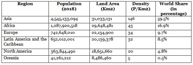
Arrange the following regions from low to high population density.
A. Oceania
B. Africa
C. North America
D. Europe
Choose the correct answer from the options given below:- a)A, C, D, B
- b)A, C, B, D
- c)C, A, D, B
- d)C, A, B, D
Correct answer is option 'A'. Can you explain this answer?
Arrange the following regions from low to high population density.
A. Oceania
B. Africa
C. North America
D. Europe
Choose the correct answer from the options given below:
A. Oceania
B. Africa
C. North America
D. Europe
Choose the correct answer from the options given below:
a)
A, C, D, B
b)
A, C, B, D
c)
C, A, D, B
d)
C, A, B, D
|
|
Rajesh Gupta answered |
Region wise Density of Population
Directions: Read the following information and answer.Indira Gandhi Canal (Nahar) Command Area
Indira Gandhi Canal, previously known as Rajasthan canal, is one of the largest canal systems in India.
The canal originates at Harike barrage in Punjab and runs parallel to Pakistan border at an average distance of 40 km in Thar Desert (Marusthali) of Rajasthan.
The construction work of the canal system has been carried out through two stages. The command area of stage-I lies in Ganganagar, Hanumangarh and northern part of Bikaner districts. It has a cultural command area of 5.53 lakh hactares. The command area of stage - II is spread over Bikaner, Jaisalmer, Barmer, Jodhpur, Nagaur and Churu districts covering culturable command area of 14.10 lakh hectares.
The introduction of canal irrigation in this dry land has transformed its ecology, economy and society. It has influenced the environmental conditions of the region both positively as well as negatively, The availability of soil moisture for a longer period of time and various afforestation and pasture development programmes under CAD have resulted in greening the land. This also helped in reducing wind erosion and siltation of canal systems. But the intensive irrigation and excessive use of water has led to the emergence of twin environmental problems of waterlogging and soil salinity. Introduction of canal irrigation has brought about a perceptible transformation in the agricultural economy of the region.
Soil moisture has been a limiting factor in a success fill growing of crops in this area, Spread of canal irrigation has led to increase in cultivated area and intensity of cropping. This has also caused waterlogging and soil salinity, arid thus, in the long run, it hampers the sustainability of agriculture.Find the dif ference between the com mand area of stage-I and stage-II choose the correct answer from the following.- a)8.97
- b)8.87
- c)8.67
- d)8.57
Correct answer is option 'D'. Can you explain this answer?
Directions: Read the following information and answer.
Indira Gandhi Canal (Nahar) Command Area
Indira Gandhi Canal, previously known as Rajasthan canal, is one of the largest canal systems in India.
The canal originates at Harike barrage in Punjab and runs parallel to Pakistan border at an average distance of 40 km in Thar Desert (Marusthali) of Rajasthan.
The construction work of the canal system has been carried out through two stages. The command area of stage-I lies in Ganganagar, Hanumangarh and northern part of Bikaner districts. It has a cultural command area of 5.53 lakh hactares. The command area of stage - II is spread over Bikaner, Jaisalmer, Barmer, Jodhpur, Nagaur and Churu districts covering culturable command area of 14.10 lakh hectares.
The introduction of canal irrigation in this dry land has transformed its ecology, economy and society. It has influenced the environmental conditions of the region both positively as well as negatively, The availability of soil moisture for a longer period of time and various afforestation and pasture development programmes under CAD have resulted in greening the land. This also helped in reducing wind erosion and siltation of canal systems. But the intensive irrigation and excessive use of water has led to the emergence of twin environmental problems of waterlogging and soil salinity. Introduction of canal irrigation has brought about a perceptible transformation in the agricultural economy of the region.
Soil moisture has been a limiting factor in a success fill growing of crops in this area, Spread of canal irrigation has led to increase in cultivated area and intensity of cropping. This has also caused waterlogging and soil salinity, arid thus, in the long run, it hampers the sustainability of agriculture.
Indira Gandhi Canal, previously known as Rajasthan canal, is one of the largest canal systems in India.
The canal originates at Harike barrage in Punjab and runs parallel to Pakistan border at an average distance of 40 km in Thar Desert (Marusthali) of Rajasthan.
The construction work of the canal system has been carried out through two stages. The command area of stage-I lies in Ganganagar, Hanumangarh and northern part of Bikaner districts. It has a cultural command area of 5.53 lakh hactares. The command area of stage - II is spread over Bikaner, Jaisalmer, Barmer, Jodhpur, Nagaur and Churu districts covering culturable command area of 14.10 lakh hectares.
The introduction of canal irrigation in this dry land has transformed its ecology, economy and society. It has influenced the environmental conditions of the region both positively as well as negatively, The availability of soil moisture for a longer period of time and various afforestation and pasture development programmes under CAD have resulted in greening the land. This also helped in reducing wind erosion and siltation of canal systems. But the intensive irrigation and excessive use of water has led to the emergence of twin environmental problems of waterlogging and soil salinity. Introduction of canal irrigation has brought about a perceptible transformation in the agricultural economy of the region.
Soil moisture has been a limiting factor in a success fill growing of crops in this area, Spread of canal irrigation has led to increase in cultivated area and intensity of cropping. This has also caused waterlogging and soil salinity, arid thus, in the long run, it hampers the sustainability of agriculture.
Find the dif ference between the com mand area of stage-I and stage-II choose the correct answer from the following.
a)
8.97
b)
8.87
c)
8.67
d)
8.57
|
|
Pj Commerce Academy answered |
The difference between the command area of stage-I and stage-II can be calculated as follows:
Stage-I Command Area:
- Culturable command area: 5.53 lakh hectares
Stage-II Command Area:
- Culturable command area: 14.10 lakh hectares
Difference between Stage-I and Stage-II Command Areas:
- 14.10 lakh hectares (Stage-II) - 5.53 lakh hectares (Stage-I) = 8.57 lakh hectares
So the correct answer is: D: 8.57
Directions: Read the following information and answer.Indira Gandhi Canal (Nahar) Command Area
Indira Gandhi Canal, previously known as Rajasthan canal, is one of the largest canal systems in India.
The canal originates at Harike barrage in Punjab and runs parallel to Pakistan border at an average distance of 40 km in Thar Desert (Marusthali) of Rajasthan.
The construction work of the canal system has been carried out through two stages. The command area of stage-I lies in Ganganagar, Hanumangarh and northern part of Bikaner districts. It has a cultural command area of 5.53 lakh hactares. The command area of stage - II is spread over Bikaner, Jaisalmer, Barmer, Jodhpur, Nagaur and Churu districts covering culturable command area of 14.10 lakh hectares.
The introduction of canal irrigation in this dry land has transformed its ecology, economy and society. It has influenced the environmental conditions of the region both positively as well as negatively, The availability of soil moisture for a longer period of time and various afforestation and pasture development programmes under CAD have resulted in greening the land. This also helped in reducing wind erosion and siltation of canal systems. But the intensive irrigation and excessive use of water has led to the emergence of twin environmental problems of waterlogging and soil salinity. Introduction of canal irrigation has brought about a perceptible transformation in the agricultural economy of the region.
Soil moisture has been a limiting factor in a success fill growing of crops in this area, Spread of canal irrigation has led to increase in cultivated area and intensity of cropping. This has also caused waterlogging and soil salinity, arid thus, in the long run, it hampers the sustainability of agriculture.Identify the correct statements.
A. Canal irrigation has brought a perc ept ible transformation in the agriculture.
B. Canal leads to afforestation.
C. It has also caused water logging and soil salinity.
D. Spread of canal led to decrease in cultivated area.
Choose the correct answer from the options given below:- a)A, C and D Only
- b)A, B and D Only
- c)A, B and C Only
- d)B, C and D Only
Correct answer is option 'C'. Can you explain this answer?
Directions: Read the following information and answer.
Indira Gandhi Canal (Nahar) Command Area
Indira Gandhi Canal, previously known as Rajasthan canal, is one of the largest canal systems in India.
The canal originates at Harike barrage in Punjab and runs parallel to Pakistan border at an average distance of 40 km in Thar Desert (Marusthali) of Rajasthan.
The construction work of the canal system has been carried out through two stages. The command area of stage-I lies in Ganganagar, Hanumangarh and northern part of Bikaner districts. It has a cultural command area of 5.53 lakh hactares. The command area of stage - II is spread over Bikaner, Jaisalmer, Barmer, Jodhpur, Nagaur and Churu districts covering culturable command area of 14.10 lakh hectares.
The introduction of canal irrigation in this dry land has transformed its ecology, economy and society. It has influenced the environmental conditions of the region both positively as well as negatively, The availability of soil moisture for a longer period of time and various afforestation and pasture development programmes under CAD have resulted in greening the land. This also helped in reducing wind erosion and siltation of canal systems. But the intensive irrigation and excessive use of water has led to the emergence of twin environmental problems of waterlogging and soil salinity. Introduction of canal irrigation has brought about a perceptible transformation in the agricultural economy of the region.
Soil moisture has been a limiting factor in a success fill growing of crops in this area, Spread of canal irrigation has led to increase in cultivated area and intensity of cropping. This has also caused waterlogging and soil salinity, arid thus, in the long run, it hampers the sustainability of agriculture.
Indira Gandhi Canal, previously known as Rajasthan canal, is one of the largest canal systems in India.
The canal originates at Harike barrage in Punjab and runs parallel to Pakistan border at an average distance of 40 km in Thar Desert (Marusthali) of Rajasthan.
The construction work of the canal system has been carried out through two stages. The command area of stage-I lies in Ganganagar, Hanumangarh and northern part of Bikaner districts. It has a cultural command area of 5.53 lakh hactares. The command area of stage - II is spread over Bikaner, Jaisalmer, Barmer, Jodhpur, Nagaur and Churu districts covering culturable command area of 14.10 lakh hectares.
The introduction of canal irrigation in this dry land has transformed its ecology, economy and society. It has influenced the environmental conditions of the region both positively as well as negatively, The availability of soil moisture for a longer period of time and various afforestation and pasture development programmes under CAD have resulted in greening the land. This also helped in reducing wind erosion and siltation of canal systems. But the intensive irrigation and excessive use of water has led to the emergence of twin environmental problems of waterlogging and soil salinity. Introduction of canal irrigation has brought about a perceptible transformation in the agricultural economy of the region.
Soil moisture has been a limiting factor in a success fill growing of crops in this area, Spread of canal irrigation has led to increase in cultivated area and intensity of cropping. This has also caused waterlogging and soil salinity, arid thus, in the long run, it hampers the sustainability of agriculture.
Identify the correct statements.
A. Canal irrigation has brought a perc ept ible transformation in the agriculture.
B. Canal leads to afforestation.
C. It has also caused water logging and soil salinity.
D. Spread of canal led to decrease in cultivated area.
Choose the correct answer from the options given below:
A. Canal irrigation has brought a perc ept ible transformation in the agriculture.
B. Canal leads to afforestation.
C. It has also caused water logging and soil salinity.
D. Spread of canal led to decrease in cultivated area.
Choose the correct answer from the options given below:
a)
A, C and D Only
b)
A, B and D Only
c)
A, B and C Only
d)
B, C and D Only
|
|
Pj Commerce Academy answered |
The correct answer is C: A, B, and C Only.
A. Canal irrigation has brought a perceptible transformation in the agriculture.
- The introduction of canal irrigation has transformed the ecology, economy, and society of the region.
- Soil moisture, which was previously a limiting factor for successful crop growth, has increased due to the spread of canal irrigation.
- This has led to an increase in cultivated area and intensity of cropping.
B. Canal leads to afforestation.
- The availability of soil moisture for a longer period of time has enabled various afforestation and pasture development programs under the Command Area Development (CAD).
- This has resulted in greening the land, reducing wind erosion, and preventing siltation of canal systems.
C. It has also caused waterlogging and soil salinity.
- Intensive irrigation and excessive use of water have led to the emergence of twin environmental problems: waterlogging and soil salinity.
- In the long run, these issues hamper the sustainability of agriculture in the region.
D. Spread of canal led to decrease in cultivated area.
- This statement is incorrect. The spread of canal irrigation has actually led to an increase in cultivated area, as mentioned in statement A.
Directions: Read the following passage very carefully and answer the questions on the basis of it: Buses merely skirt the periphery. Autorickshaws cannot go there. Dharavi is part of central Bombay where three wheelers are banned.
Only one main road traverses the slum, the miscalled ‘ninety-foot road’, which has been reduced to less than half of that for most of its length. Some of the side alleys and lanes are so narrow that not even a bicycle can pass. The whole neighbourhood consists of temporary buddings, two or three storeyed high with rusty iron stairways to the upper part, where a single room is rented by a whole family, sometimes accommodating twelve or more people; it is a land of tropical versions of the industrial dwelling of Victorian London’s East end.
But Dharavi is a keeper of more sombre secrets than the revulsion it inspires in the rich; a revulsion, moreover, that is, in direct proportion to the role it serves in the creation of the wealth of Bombay. In this place of shadowless, tressless sunlight, uncollected garbage, stagnant pools of foul water, where the only non-human creatures are the shining black crows and long grey rats, some of the most beautiful, valuable and useful articles in India are made.
From Dharavi come delicate ceramics and pottery, exquisite embroidery and Zari work, sophisticated leather goods, high-fashion garments, finely- wrought metal work, delicate jewellery settings, wood carvings and furniture that would find its way into the richest houses, both in India and abroad...
Dharavi was an arm of the sea, that was filled by waste, largely produced by the people have come to live there: Scheduled Castes and poor Muslims. It comprises rambling buildings of corrugated metal, 20 meter high in places, used for the treatment of hides and tanning.
There are pleasant parts, but rotting garbage is everywhere....”Q. Dharavi was an arm of the sea. it was filled by: _____.- a)Forests
- b)Cargo
- c)Waste
- d)Population
Correct answer is option 'C'. Can you explain this answer?
Directions: Read the following passage very carefully and answer the questions on the basis of it:
Buses merely skirt the periphery. Autorickshaws cannot go there. Dharavi is part of central Bombay where three wheelers are banned.
Only one main road traverses the slum, the miscalled ‘ninety-foot road’, which has been reduced to less than half of that for most of its length. Some of the side alleys and lanes are so narrow that not even a bicycle can pass. The whole neighbourhood consists of temporary buddings, two or three storeyed high with rusty iron stairways to the upper part, where a single room is rented by a whole family, sometimes accommodating twelve or more people; it is a land of tropical versions of the industrial dwelling of Victorian London’s East end.
But Dharavi is a keeper of more sombre secrets than the revulsion it inspires in the rich; a revulsion, moreover, that is, in direct proportion to the role it serves in the creation of the wealth of Bombay. In this place of shadowless, tressless sunlight, uncollected garbage, stagnant pools of foul water, where the only non-human creatures are the shining black crows and long grey rats, some of the most beautiful, valuable and useful articles in India are made.
From Dharavi come delicate ceramics and pottery, exquisite embroidery and Zari work, sophisticated leather goods, high-fashion garments, finely- wrought metal work, delicate jewellery settings, wood carvings and furniture that would find its way into the richest houses, both in India and abroad...
Dharavi was an arm of the sea, that was filled by waste, largely produced by the people have come to live there: Scheduled Castes and poor Muslims. It comprises rambling buildings of corrugated metal, 20 meter high in places, used for the treatment of hides and tanning.
There are pleasant parts, but rotting garbage is everywhere....”
Q. Dharavi was an arm of the sea. it was filled by: _____.
a)
Forests
b)
Cargo
c)
Waste
d)
Population
|
|
Prasenjit Rane answered |
Understanding the Context
The passage provides a vivid description of Dharavi, a slum in central Bombay, emphasizing its socio-economic conditions and the paradox of wealth creation amidst poverty. It mentions that Dharavi was once an arm of the sea, which has been filled by waste, predominantly generated by the local populace.
Analyzing the Options
To answer the question, we need to examine the provided options in relation to the context of Dharavi:
Conclusion
Given this analysis, the correct answer is option 'C', as it accurately reflects the passage's assertion that the area was filled with waste, highlighting the environmental challenges faced by the residents of Dharavi. This point underscores the juxtaposition of economic activity and the resultant neglect of living conditions.
The passage provides a vivid description of Dharavi, a slum in central Bombay, emphasizing its socio-economic conditions and the paradox of wealth creation amidst poverty. It mentions that Dharavi was once an arm of the sea, which has been filled by waste, predominantly generated by the local populace.
Analyzing the Options
To answer the question, we need to examine the provided options in relation to the context of Dharavi:
- a) Forests - This option does not align with the description of Dharavi being filled by something; it does not denote waste or a human-made environment.
- b) Cargo - While cargo might imply goods, it does not relate directly to waste or the transformation of land.
- c) Waste - This option is directly mentioned in the passage. Dharavi was filled by waste produced by the very people living there, emphasizing the impact of their economic activities on the environment.
- d) Population - Although the population is a significant aspect, the passage specifically mentions that the arm of the sea was filled by waste, not by the population itself.
Conclusion
Given this analysis, the correct answer is option 'C', as it accurately reflects the passage's assertion that the area was filled with waste, highlighting the environmental challenges faced by the residents of Dharavi. This point underscores the juxtaposition of economic activity and the resultant neglect of living conditions.
Arrange the f ollowing incidents in sequential order according to their developments.
A. Air' transport was nationalized.
B. Air transport was provided by four major companies.
C. Air transport in India was hunched between Allahabad and Naini.
D. Bharat Airways. Himalayan av iation Ltd. joined the services.
Choose the correct answer from the options given below:- a)D, A, C, B
- b)A, B, C, D
- c)C, B, D, A
- d)B, A, C, D
Correct answer is option 'C'. Can you explain this answer?
Arrange the f ollowing incidents in sequential order according to their developments.
A. Air' transport was nationalized.
B. Air transport was provided by four major companies.
C. Air transport in India was hunched between Allahabad and Naini.
D. Bharat Airways. Himalayan av iation Ltd. joined the services.
Choose the correct answer from the options given below:
A. Air' transport was nationalized.
B. Air transport was provided by four major companies.
C. Air transport in India was hunched between Allahabad and Naini.
D. Bharat Airways. Himalayan av iation Ltd. joined the services.
Choose the correct answer from the options given below:
a)
D, A, C, B
b)
A, B, C, D
c)
C, B, D, A
d)
B, A, C, D
|
|
Rajesh Gupta answered |
History of Indian Airlines: 1911 - Air transport in India was launched between Allahabad and Naini. 1947 - Air transport was provided by four major companies namely Indian National Airways, Tata Sons Limited, Air Services of India and Deccan Airways. 1951 - Four more companies joined the services, Bharat Airways, Himalayan Aviation Limited, Airways India and Kalinga Airlines. 1953 - Air transport was nationalised and two Corporations, Air India International and Indian Airlines were formed. Now Indian Airlines is known as ‘Indian’.
Nagla, Dhani, Para, Palli are local names of- a)Dispersed settlements
- b)Hamleted settlements
- c)Agglomerated settlements
- d)Nucleated settlements
Correct answer is option 'B'. Can you explain this answer?
Nagla, Dhani, Para, Palli are local names of
a)
Dispersed settlements
b)
Hamleted settlements
c)
Agglomerated settlements
d)
Nucleated settlements
|
|
Rohit Sharma answered |
Hamleted Settlements - Sometimes settlement is fragmented into several units physically separated from each other bearing a common name. These units are locally called panna, para, palli, nagla, dhani, etc. in various parts of the country. This segmentation of a large village is often motivated by social and ethnic factors. Such villages are more frequently found in the middle and lower Ganga plain, Chhattisgarh and lower valleys of the Himalayas.
Dharavi is known to manufacture certain specific products.- a)Ceramic, Jewellery and wood carv ing
- b)Information technology and services
- c)Books and newspapers
- d)Fans, electric bulbs and TVs
Correct answer is option 'A'. Can you explain this answer?
Dharavi is known to manufacture certain specific products.
a)
Ceramic, Jewellery and wood carv ing
b)
Information technology and services
c)
Books and newspapers
d)
Fans, electric bulbs and TVs
|
|
Priyanka Chavan answered |
Dharavi, a densely populated area in Mumbai, India, is known for its vibrant manufacturing sector. It specializes in the production of specific products, particularly in the areas of ceramics, jewellery, and wood carving.
1. Ceramic:
Dharavi has a thriving ceramic industry that produces a wide range of ceramic products. Skilled artisans in the area create beautiful pottery, decorative tiles, and other ceramic items. These products are often handmade and intricately designed, showcasing the craftsmanship of the local artisans. The ceramic industry in Dharavi not only serves the local market but also caters to national and international clients.
2. Jewellery:
Dharavi is also renowned for its jewellery manufacturing sector. Numerous small-scale workshops and units are involved in crafting exquisite jewellery pieces. Skilled artisans work with various materials such as gold, silver, and precious stones to create stunning necklaces, earrings, bangles, and other accessories. The jewellery produced in Dharavi is known for its intricate designs and fine craftsmanship.
3. Wood Carving:
Wood carving is another significant industry in Dharavi. Skilled craftsmen carve intricate designs on wood to create a variety of products such as furniture, decorative items, and sculptures. The wood carving industry in Dharavi is known for its attention to detail and artistic finesse. These beautifully carved wooden products find customers both locally and globally.
Dharavi's manufacturing sector is a major source of employment for the local population. The artisans and craftsmen in Dharavi demonstrate their skills and creativity through the production of these specific products. The products manufactured in Dharavi not only cater to the domestic market but also contribute to the export industry, earning foreign exchange for the country.
In conclusion, Dharavi's manufacturing sector specializes in ceramic, jewellery, and wood carving products. These industries not only provide livelihoods for the local population but also showcase the rich artistic traditions and craftsmanship of the area.
Sustainability of human development is best explained by which one of the following properties.- a)Increase in income of the country
- b)Building up financial capability in people
- c)Enhanced standard of liv ing
- d)Continuity in the av ailability of opportunities to each generation
Correct answer is option 'D'. Can you explain this answer?
Sustainability of human development is best explained by which one of the following properties.
a)
Increase in income of the country
b)
Building up financial capability in people
c)
Enhanced standard of liv ing
d)
Continuity in the av ailability of opportunities to each generation
|
|
Priyanka Chavan answered |
Sustainability of Human Development
Sustainability in human development refers to the ability of society to ensure that future generations can meet their own needs while improving the quality of life for all. The concept encompasses various dimensions, but the most crucial is the continuity in the availability of opportunities for each generation.
Key Reasons for Choosing Option D
- Intergenerational Equity: Sustainability emphasizes fairness between generations. Ensuring that future generations have access to the same or better opportunities is fundamental for a balanced and equitable society.
- Long-term Viability: While increasing income, building financial capability, and enhancing living standards are important, they may not be sustainable if resources are depleted or if opportunities are not preserved for the future. Option D ensures that progress is not a one-time achievement but a continuous process.
- Environmental and Social Responsibility: A sustainable approach considers not just economic factors but also environmental and social aspects. Providing opportunities for education, employment, and health for future generations ensures a holistic approach to development.
- Resilience to Change: Societies that focus on sustaining opportunities are better equipped to handle changes and challenges, such as economic downturns or climate change, leading to more resilient communities.
In conclusion, while all options contribute to human development, the sustainability aspect is best captured by the continuity of opportunities across generations, making option D the correct choice. This approach ensures that development is inclusive, equitable, and forward-looking.
Read the following statements regarding ports.
A. Oil ports deal with processing and shipping of oil.
B. Packet stations are concerned with passenger transport covering long distance.
C. At Entrepot ports goods are brought from different countries for export.
D. Nav al ports are of strategic importance.
Choose the correct answer from the options given below:- a)A, B and D only
- b)A, B and C only
- c)A, C and D only
- d)B, C and D only
Correct answer is option 'C'. Can you explain this answer?
Read the following statements regarding ports.
A. Oil ports deal with processing and shipping of oil.
B. Packet stations are concerned with passenger transport covering long distance.
C. At Entrepot ports goods are brought from different countries for export.
D. Nav al ports are of strategic importance.
Choose the correct answer from the options given below:
a)
A, B and D only
b)
A, B and C only
c)
A, C and D only
d)
B, C and D only
|
|
Rohit Sharma answered |
Oil Ports deal in the processing and shipping of oil. Packet Station is also known as ferry ports.These packet stations are exclusively concerned with the transportation of passengers and mail across water bodies covering short distances. Entrepot Ports are collection centres where the goods are brought from different countries for export. Naval Ports are ports which have only strategic importance. These ports serve warships and have repair workshops for them.
Who introduced the concept of Neo determinism or stop and go determinism in Geography?- a)Ratzel
- b)Griffith Taylor
- c)Paul Vidal de la blache
- d)Ellen C Semple
Correct answer is option 'B'. Can you explain this answer?
Who introduced the concept of Neo determinism or stop and go determinism in Geography?
a)
Ratzel
b)
Griffith Taylor
c)
Paul Vidal de la blache
d)
Ellen C Semple
|
|
Rajdeep Choudhury answered |
Introduction:
The concept of Neo determinism or stop and go determinism in Geography was introduced by Griffith Taylor.
Explanation:
Griffith Taylor was a renowned geographer who made significant contributions to the field of human geography. He introduced the concept of Neo determinism or stop and go determinism in his book "Environment and Nation: Geographical Factors in the Cultural and Political History of Nations" published in 1920.
Neo Determinism:
Neo determinism, also known as stop and go determinism, is a geographical theory that emphasizes the influence of both environmental and human factors on the development of societies. According to this theory, while the environment sets certain limitations and opportunities for human societies, it is the human agency that ultimately determines the course of development.
Influence of Environmental Factors:
Taylor acknowledged the role of environmental factors in shaping human societies. He believed that the physical characteristics of a region, such as climate, topography, and natural resources, can significantly impact the cultural, economic, and political development of a society. However, he argued that these environmental factors do not solely determine the destiny of a society.
Human Agency:
Taylor also emphasized the importance of human agency in shaping the course of development. He believed that human societies have the ability to adapt, innovate, and overcome environmental limitations. Taylor argued that societies can actively utilize their resources, technology, and knowledge to overcome environmental challenges and drive their development forward.
Criticism and Further Development:
While Taylor's concept of Neo determinism provided a more nuanced understanding of the relationship between environment and society, it also faced criticism. Some geographers argued that the concept downplayed the role of social, cultural, and economic factors in development. Over time, the concept of Neo determinism has been further developed and refined by other geographers, taking into account the complex interactions between environmental and human factors.
Conclusion:
Griffith Taylor introduced the concept of Neo determinism or stop and go determinism in Geography. This theory highlights the interaction between environmental factors and human agency in shaping the development of societies. While environmental factors provide limitations and opportunities, human societies have the ability to adapt and overcome these challenges through their actions and innovations.
Which one of the following state of India has the lowest rank in the human development index according to Indian National Human Development Report 2011?- a)Rajasthan
- b)Bihar
- c)Chhattisgarh
- d)Haryana
Correct answer is option 'C'. Can you explain this answer?
Which one of the following state of India has the lowest rank in the human development index according to Indian National Human Development Report 2011?
a)
Rajasthan
b)
Bihar
c)
Chhattisgarh
d)
Haryana
|
|
Amita Das answered |
Chhattisgarh with HDI v alue of 0.358 has the lowest rank.
Read the following statements care folly concerning Indian Railways.
A. Indian Railways is one of the longest in the world.
B. It is the largest gov ernment undertaking in the country.
C. Indian Railway is div ided into 20 zones.
D. Indian Railway was introduced in 1853.Choose the correct answer from the options given below:- a)A, C and D only
- b)B, C and D Only
- c)A, B and C Only
- d)A, B and D Only
Correct answer is option 'D'. Can you explain this answer?
Read the following statements care folly concerning Indian Railways.
A. Indian Railways is one of the longest in the world.
B. It is the largest gov ernment undertaking in the country.
C. Indian Railway is div ided into 20 zones.
D. Indian Railway was introduced in 1853.
A. Indian Railways is one of the longest in the world.
B. It is the largest gov ernment undertaking in the country.
C. Indian Railway is div ided into 20 zones.
D. Indian Railway was introduced in 1853.
Choose the correct answer from the options given below:
a)
A, C and D only
b)
B, C and D Only
c)
A, B and C Only
d)
A, B and D Only
|
|
Anjali Sharma answered |
Indian Railways, network is one of the longest in the world. It facilitates the mov ement of both freight and passengers and contributes to the growth of the economy. Indian Railways is the largest government undertaking in the country. The length of Indian Railways network was 67,956 km (Railway yearbook 2019-20). It’s very large size puts a lot of pressure on a centralised railway management system. Thus, in India, the railway system has been divided into 16 zones.
Determine the reason why developed economies are retreating from mining, refining and processing of minerals?- a)Output is low
- b)High labour cost
- c)lack of capital
- d)lack of technology
Correct answer is option 'B'. Can you explain this answer?
Determine the reason why developed economies are retreating from mining, refining and processing of minerals?
a)
Output is low
b)
High labour cost
c)
lack of capital
d)
lack of technology
|
|
Naina Sharma answered |
The developed economies are retreating from mining, processing and refining stages of production due to high labour costs, while the developing countries with large labour force and striving for higher standard of living are becoming more important.
Which one of the following characteristics is not a feature of intensive subsistence agriculture?- a)Per capita high labour productivity
- b)Small farm size
- c)Mostly agricultural activities done by manual labour
- d)To maintain soil fertility farm yard manure is being used
Correct answer is option 'A'. Can you explain this answer?
Which one of the following characteristics is not a feature of intensive subsistence agriculture?
a)
Per capita high labour productivity
b)
Small farm size
c)
Mostly agricultural activities done by manual labour
d)
To maintain soil fertility farm yard manure is being used
|
|
Anjali Sharma answered |
Intensive Subsistence Agriculture: This type of agriculture is largely found in densely populated regions of monsoon Asia. Basically, there are two types of intensive subsistence agriculture.
(i) Intensive subsistence agriculture dominated by wet paddy cultivation: This type of agriculture is characterised by dominance of the rice crop. Land holdings are very small due to the high density of population. Farmers work with the help of family labour leading to intensive use of land. Use of machinery is limited and most of the agricultural operations are done by manual labour. Farm yard manure is used to maintain the fertility of the soil. In this type of agriculture, the yield per unit area is high but per labour productivity is low.
(ii) Intensive subsidence agriculture dominated by crops other than paddy: Due to the difference in relief, climate, soil and some of the other geographical factors, it is not practical to grow paddy in many parts of monsoon Asia. Wheat, soyabean, barley and sorghum are grown in northern China, Manchuria, North Korea and North Japan. In India wheat is grown in western parts of the Indo-Gangetic plains and millets are grown in dry parts of western and southern India. Most of the characteristics of this type of agriculture are similar to those dominated by wet paddy except that irrigation is often used.
(ii) Intensive subsidence agriculture dominated by crops other than paddy: Due to the difference in relief, climate, soil and some of the other geographical factors, it is not practical to grow paddy in many parts of monsoon Asia. Wheat, soyabean, barley and sorghum are grown in northern China, Manchuria, North Korea and North Japan. In India wheat is grown in western parts of the Indo-Gangetic plains and millets are grown in dry parts of western and southern India. Most of the characteristics of this type of agriculture are similar to those dominated by wet paddy except that irrigation is often used.
Which one of the following is the push factor for migration?- a)Employment opportunity
- b)Education and health facility
- c)Political stability
- d)Poor living conditions
Correct answer is option 'D'. Can you explain this answer?
Which one of the following is the push factor for migration?
a)
Employment opportunity
b)
Education and health facility
c)
Political stability
d)
Poor living conditions
|
|
Jyoti Das answered |
Understanding Push Factors in Migration
Migration is influenced by various factors that can either encourage individuals to move (pull factors) or compel them to leave their current location (push factors). Among these, poor living conditions serve as a significant push factor.
What are Push Factors?
- Push factors are negative aspects or conditions that drive individuals to leave their home country or region.
- They include issues such as economic hardship, political instability, environmental challenges, and social unrest.
Why Poor Living Conditions?
- Poor living conditions encompass inadequate housing, lack of basic amenities, and insufficient access to clean water and sanitation.
- Individuals facing these dire circumstances often seek better environments where their quality of life can improve.
Examples of Poor Living Conditions:
- Economic Hardship: High levels of unemployment and poverty can lead to a struggle for basic necessities, prompting people to migrate in search of better opportunities.
- Health Risks: Limited access to healthcare services and the prevalence of diseases can push individuals to seek better health facilities in other regions.
- Safety Concerns: Areas that are plagued with violence, crime, or political unrest can force residents to flee for their safety.
Contrasting Pull Factors:
- In contrast, pull factors, such as employment opportunities, education, and political stability, attract individuals to new locations. These factors are generally positive and represent the benefits of moving.
Conclusion:
In summary, poor living conditions are a compelling push factor that drives migration. When individuals find their current environment untenable, they are more likely to seek a better quality of life elsewhere, making it a crucial aspect to consider in the study of migration trends.
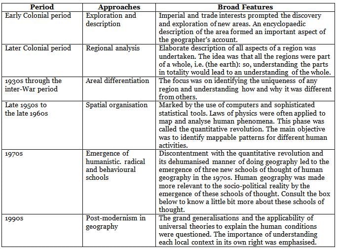
Arrange the following broad features of different approaches of Human Geography in order to it’s evolution from oldest to latest.
A. Imperial and trade interests prompted the discovery and exploration of new areas.
B. Discontentment with the quantitativ e rev olution
C. Identifying mappable patterns for different human activities
D. Focus on identifying the uniqueness of any region
E. Elaborate description of all aspects of a region were undertaken
Choose the correct answer from the option given below:- a)A, E, C, B, D
- b)A, E, D, C, B
- c)A, D, B, C, E
- d)A, D, B, E, C
Correct answer is option 'B'. Can you explain this answer?
Arrange the following broad features of different approaches of Human Geography in order to it’s evolution from oldest to latest.
A. Imperial and trade interests prompted the discovery and exploration of new areas.
B. Discontentment with the quantitativ e rev olution
C. Identifying mappable patterns for different human activities
D. Focus on identifying the uniqueness of any region
E. Elaborate description of all aspects of a region were undertaken
Choose the correct answer from the option given below:
a)
A, E, C, B, D
b)
A, E, D, C, B
c)
A, D, B, C, E
d)
A, D, B, E, C
|
|
Swara Patel answered |
Evolution of Human Geography Approaches
The evolution of Human Geography can be traced through various approaches that reflect changing perspectives and methodologies over time. The correct order, as identified in option B, is as follows:
A. Imperial and trade interests prompted the discovery and exploration of new areas.
- This marks the earliest phase of Human Geography, where exploration was driven by colonial ambitions and the quest for trade routes.
E. Elaborate description of all aspects of a region were undertaken.
- Following discovery, the focus shifted to detailed descriptions of regions, influenced by early geographers who aimed to document the physical and cultural characteristics of areas.
D. Focus on identifying the uniqueness of any region.
- The late 19th and early 20th centuries saw a growing interest in regional geography, emphasizing the distinctive features of specific areas, leading to comparative studies between different regions.
C. Identifying mappable patterns for different human activities.
- The mid-20th century brought about the quantitative revolution, where geographers began to employ statistical methods to analyze spatial patterns and human activities, marking a shift towards empirical research.
B. Discontentment with the quantitative revolution.
- In the latter part of the 20th century, a critique of the quantitative approach emerged, leading to a revival of qualitative methods, including humanistic and phenomenological perspectives that emphasized the lived experiences of people in different places.
This sequence illustrates the dynamic nature of Human Geography, evolving from explorative and descriptive methods to more analytical and critical approaches, reflecting broader societal changes and academic debates.
Which one of the following set of pairs are correctly matched
A. Shipbuilding industry - Lusaka
B. Aircraft industry - Edinburg
C. Automobile industry - Detroit
D. Iron and steel industry - Chicago-Gary
Choose the correct answer from the option given below:- a)A and B only
- b)A and C only
- c)A & D only
- d)C & D only
Correct answer is option 'D'. Can you explain this answer?
Which one of the following set of pairs are correctly matched
A. Shipbuilding industry - Lusaka
B. Aircraft industry - Edinburg
C. Automobile industry - Detroit
D. Iron and steel industry - Chicago-Gary
Choose the correct answer from the option given below:
A. Shipbuilding industry - Lusaka
B. Aircraft industry - Edinburg
C. Automobile industry - Detroit
D. Iron and steel industry - Chicago-Gary
Choose the correct answer from the option given below:
a)
A and B only
b)
A and C only
c)
A & D only
d)
C & D only
|
|
Amita Das answered |
The Iron and Steel industry is one of the most complex and capital-intensive industries and is concentrated in the advanced countries of North America, Europe and Asia. In U.S.A, most of the production comes from the north Appalachian region (Pittsburgh), Great Lake region (ChicagoGary, Erie, Cleveland, Lorain, Buffalo and Duluth) and the Atlantic Coast (Sparrows Point and Morisville). Automobile industry is the most prominent industry in Detroit.
Which among the following is an Entrepot port for Asia?- a)Mumbai
- b)Singapore
- c)Tokyo
- d)Karachi
Correct answer is option 'B'. Can you explain this answer?
Which among the following is an Entrepot port for Asia?
a)
Mumbai
b)
Singapore
c)
Tokyo
d)
Karachi
|
|
Athul Chawla answered |
Entrepot port for Asia - Singapore
Introduction:
An entrepot port is a trading hub where goods are imported, stored, and then re-exported to other regions. It acts as a transit point for international trade. Among the options given, Singapore is recognized as an entrepot port for Asia. Let's delve into the reasons behind this choice.
Strategic Geographical Location:
One of the primary factors that make Singapore an ideal entrepot port is its strategic geographical location. Situated at the southern tip of the Malay Peninsula, Singapore lies at the crossroads of major shipping routes in Asia. It serves as a gateway for maritime trade between the Pacific and Indian Oceans, making it an important transit point for goods coming from and going to various parts of Asia.
Efficient Infrastructure:
Singapore boasts a highly developed and efficient infrastructure, which further enhances its role as an entrepot port. It has state-of-the-art port facilities, including deep-water berths and modern container terminals. The Port of Singapore is one of the busiest and most advanced ports in the world, capable of handling large volumes of cargo. Its efficient logistics network ensures smooth movement of goods, facilitating quick transshipment and re-export.
Free Trade Policies:
To foster trade and investment, Singapore has implemented favorable free trade policies. It has an open economy with minimal trade barriers, low import duties, and a simplified customs clearance process. These policies attract businesses and encourage them to use Singapore as a transshipment center. Additionally, Singapore has signed numerous free trade agreements with countries around the world, further boosting its entrepot status.
Business-friendly Environment:
Singapore has established itself as a business-friendly environment with a stable political climate, strong rule of law, and efficient governance. It offers a conducive environment for international trade, attracting multinational corporations to set up their regional headquarters or distribution centers in the country. The presence of these companies contributes to the growth of Singapore's entrepot trade.
Conclusion:
In conclusion, Singapore is recognized as an entrepot port for Asia due to its strategic geographical location, efficient infrastructure, favorable free trade policies, and business-friendly environment. These factors have contributed to Singapore's status as a major trading hub, facilitating the movement of goods between various regions in Asia and beyond.
Which one of the following is not an approach to human development?- a)Basic needs approach
- b)Capability approach
- c)Need fulfilment approach
- d)Welfare approach
Correct answer is option 'C'. Can you explain this answer?
Which one of the following is not an approach to human development?
a)
Basic needs approach
b)
Capability approach
c)
Need fulfilment approach
d)
Welfare approach
|
|
Kiran Mehta answered |
Some of the important approaches are:
(a) The income approach;
(b) The welfare approach;
(c) Minimum needs approach; and
(d) Capabilities approach.
(a) The income approach;
(b) The welfare approach;
(c) Minimum needs approach; and
(d) Capabilities approach.
In the production of cotton. India stands at which rank in the world cotton production?- a)First
- b)Second
- c)Third
- d)Fourth
Correct answer is option 'B'. Can you explain this answer?
In the production of cotton. India stands at which rank in the world cotton production?
a)
First
b)
Second
c)
Third
d)
Fourth
|
|
Amita Das answered |
India ranks second in the world in the production of cotton after China. Cotton occupies about 4.7 per cent of total cropped area in the country.
“The physical extent of land on which crops are sown and harvested” is known by which one of the following land use categories?- a)Net Area Sown
- b)Current Fallow
- c)Fallow other than Current Fallow
- d)Barren and Wastelands
Correct answer is option 'A'. Can you explain this answer?
“The physical extent of land on which crops are sown and harvested” is known by which one of the following land use categories?
a)
Net Area Sown
b)
Current Fallow
c)
Fallow other than Current Fallow
d)
Barren and Wastelands
|
|
Arun Yadav answered |
Net Area Sown: The physical extent of land on which crops are sown and harv ested is known as net sown area.
Directions: Read the following passage very carefully and answer the questions on the basis of it: Buses merely skirt the periphery. Autorickshaws cannot go there. Dharavi is part of central Bombay where three wheelers are banned.
Only one main road traverses the slum, the miscalled ‘ninety-foot road’, which has been reduced to less than half of that for most of its length. Some of the side alleys and lanes are so narrow that not even a bicycle can pass. The whole neighbourhood consists of temporary buddings, two or three storeyed high with rusty iron stairways to the upper part, where a single room is rented by a whole family, sometimes accommodating twelve or more people; it is a land of tropical versions of the industrial dwelling of Victorian London’s East end.
But Dharavi is a keeper of more sombre secrets than the revulsion it inspires in the rich; a revulsion, moreover, that is, in direct proportion to the role it serves in the creation of the wealth of Bombay. In this place of shadowless, tressless sunlight, uncollected garbage, stagnant pools of foul water, where the only non-human creatures are the shining black crows and long grey rats, some of the most beautiful, valuable and useful articles in India are made.
From Dharavi come delicate ceramics and pottery, exquisite embroidery and Zari work, sophisticated leather goods, high-fashion garments, finely- wrought metal work, delicate jewellery settings, wood carvings and furniture that would find its way into the richest houses, both in India and abroad...
Dharavi was an arm of the sea, that was filled by waste, largely produced by the people have come to live there: Scheduled Castes and poor Muslims. It comprises rambling buildings of corrugated metal, 20 meter high in places, used for the treatment of hides and tanning.
There are pleasant parts, but rotting garbage is everywhere....”Q. Dharavi slum habitation is a part of _______.- a)Central Bombay
- b)New Mumbai
- c)South Bombay
- d)East Bombay
Correct answer is option 'A'. Can you explain this answer?
Directions: Read the following passage very carefully and answer the questions on the basis of it:
Buses merely skirt the periphery. Autorickshaws cannot go there. Dharavi is part of central Bombay where three wheelers are banned.
Only one main road traverses the slum, the miscalled ‘ninety-foot road’, which has been reduced to less than half of that for most of its length. Some of the side alleys and lanes are so narrow that not even a bicycle can pass. The whole neighbourhood consists of temporary buddings, two or three storeyed high with rusty iron stairways to the upper part, where a single room is rented by a whole family, sometimes accommodating twelve or more people; it is a land of tropical versions of the industrial dwelling of Victorian London’s East end.
But Dharavi is a keeper of more sombre secrets than the revulsion it inspires in the rich; a revulsion, moreover, that is, in direct proportion to the role it serves in the creation of the wealth of Bombay. In this place of shadowless, tressless sunlight, uncollected garbage, stagnant pools of foul water, where the only non-human creatures are the shining black crows and long grey rats, some of the most beautiful, valuable and useful articles in India are made.
From Dharavi come delicate ceramics and pottery, exquisite embroidery and Zari work, sophisticated leather goods, high-fashion garments, finely- wrought metal work, delicate jewellery settings, wood carvings and furniture that would find its way into the richest houses, both in India and abroad...
Dharavi was an arm of the sea, that was filled by waste, largely produced by the people have come to live there: Scheduled Castes and poor Muslims. It comprises rambling buildings of corrugated metal, 20 meter high in places, used for the treatment of hides and tanning.
There are pleasant parts, but rotting garbage is everywhere....”
Only one main road traverses the slum, the miscalled ‘ninety-foot road’, which has been reduced to less than half of that for most of its length. Some of the side alleys and lanes are so narrow that not even a bicycle can pass. The whole neighbourhood consists of temporary buddings, two or three storeyed high with rusty iron stairways to the upper part, where a single room is rented by a whole family, sometimes accommodating twelve or more people; it is a land of tropical versions of the industrial dwelling of Victorian London’s East end.
But Dharavi is a keeper of more sombre secrets than the revulsion it inspires in the rich; a revulsion, moreover, that is, in direct proportion to the role it serves in the creation of the wealth of Bombay. In this place of shadowless, tressless sunlight, uncollected garbage, stagnant pools of foul water, where the only non-human creatures are the shining black crows and long grey rats, some of the most beautiful, valuable and useful articles in India are made.
From Dharavi come delicate ceramics and pottery, exquisite embroidery and Zari work, sophisticated leather goods, high-fashion garments, finely- wrought metal work, delicate jewellery settings, wood carvings and furniture that would find its way into the richest houses, both in India and abroad...
Dharavi was an arm of the sea, that was filled by waste, largely produced by the people have come to live there: Scheduled Castes and poor Muslims. It comprises rambling buildings of corrugated metal, 20 meter high in places, used for the treatment of hides and tanning.
There are pleasant parts, but rotting garbage is everywhere....”
Q. Dharavi slum habitation is a part of _______.
a)
Central Bombay
b)
New Mumbai
c)
South Bombay
d)
East Bombay
|
|
Prasenjit Rane answered |
Location of Dharavi
Dharavi is identified as being part of central Bombay, a crucial detail that highlights its geographic significance within the city.
Key Points
- Central Bombay: The passage explicitly states that Dharavi is located in central Bombay, indicating its central role in the urban landscape.
- Surrounding Areas: The mention of buses skirting the periphery and the ban on autorickshaws further emphasizes that Dharavi is nestled within a densely populated and urbanized area.
- Urban Challenges: Descriptions of the narrow alleys, temporary buildings, and the overall living conditions illustrate the challenges faced by its inhabitants, reinforcing its identification as a slum within a major urban center.
Contextual Significance
- Economic Role: Despite its designation as a slum, Dharavi plays a vital role in the economy of Bombay, contributing significantly to the wealth of the city through its production of valuable goods.
- Demographic Composition: The passage notes that the population largely consists of Scheduled Castes and poor Muslims, providing insight into the socio-economic fabric of the area.
Conclusion
In summary, the correct identification of Dharavi as part of central Bombay is not only a geographical fact but also a reflection of the socio-economic dynamics at play in this densely populated urban area. The context provided in the passage highlights both the challenges and the contributions of Dharavi to the overall wealth and character of Bombay.
Read the following care folly with reference to Human Development in India:
A. Kerala is at the top in human development index.
B. States showing higher total literacy rates hav e huge gaps between male-female literacy.
C. Odisha is am ong the top fiv e states in human development category.
D. India has been among the medium HD I category.
Choose the correct answer from the options given below:- a)A and B Only
- b)A and C Only
- c)A and D Only
- d)B and C Only
Correct answer is option 'C'. Can you explain this answer?
Read the following care folly with reference to Human Development in India:
A. Kerala is at the top in human development index.
B. States showing higher total literacy rates hav e huge gaps between male-female literacy.
C. Odisha is am ong the top fiv e states in human development category.
D. India has been among the medium HD I category.
Choose the correct answer from the options given below:
a)
A and B Only
b)
A and C Only
c)
A and D Only
d)
B and C Only
|
|
Anjali Pillai answered |
Introduction
The given care folly is about human development in India. It provides information about different states and their ranking in the Human Development Index (HDI), as well as the literacy rates and HDI category of India as a whole. Let's analyze each statement and determine the correct answer.
A. Kerala is at the top in human development index.
- Kerala is a state in southern India known for its high levels of human development.
- It has consistently ranked at the top in terms of HDI among all Indian states.
- The state has achieved significant progress in areas such as education, healthcare, and standard of living, contributing to its high HDI ranking.
B. States showing higher total literacy rates have huge gaps between male-female literacy.
- This statement suggests that states with higher overall literacy rates tend to have significant disparities between male and female literacy rates.
- In India, there is a long-standing gender gap in literacy rates, with the male literacy rate being higher than the female literacy rate.
- While some states have made efforts to bridge this gap, there are still significant disparities in many regions, resulting in an overall lower female literacy rate compared to males.
C. Odisha is among the top five states in the human development category.
- Odisha is a state in eastern India known for its diverse culture and rich heritage.
- While it has made progress in certain aspects of human development, it does not rank among the top five states in terms of HDI.
- The state faces challenges in areas like education, healthcare, and poverty reduction, which impact its overall human development.
D. India has been among the medium HDI category.
- The Human Development Index categorizes countries into four categories: very high, high, medium, and low.
- India falls into the medium HDI category, indicating that it has made progress in various dimensions of human development but still has room for improvement.
- The country has made significant strides in areas such as poverty reduction, education, and healthcare, but challenges like income inequality and regional disparities persist.
Conclusion
Based on the analysis of the given statements, the correct answer is option 'C' (A and D Only). Kerala being at the top in HDI and Odisha being among the top five states in human development are incorrect statements. However, India being in the medium HDI category and states with higher overall literacy rates having significant gaps between male and female literacy are accurate statements.
‘Neeru-Meeru’ a watershed development and management programme is associated with which of the following?- a)Rajasthan
- b)Andhra Pradesh
- c)Tamil Nadu
- d)Haryana
Correct answer is option 'B'. Can you explain this answer?
‘Neeru-Meeru’ a watershed development and management programme is associated with which of the following?
a)
Rajasthan
b)
Andhra Pradesh
c)
Tamil Nadu
d)
Haryana
|
|
Rajesh Gupta answered |
Neeru-Meeru (Water and You) programme (in Andhra Pradesh) and Arvary Pani Sansad (in Alwar, Rajasthan) have taken up constructions of various water-harvesting structures such as percolation tanks, dug out ponds (Johad), check dams, etc., through people's participation.
The Swachh Bharat Mission (SBM) launched by the Government of India is a part of- a)Rural renewable mission
- b)Rural Souchalaya mission
- c)Urban Souchalaya mission
- d)Both (b) and (c)
Correct answer is option 'D'. Can you explain this answer?
The Swachh Bharat Mission (SBM) launched by the Government of India is a part of
a)
Rural renewable mission
b)
Rural Souchalaya mission
c)
Urban Souchalaya mission
d)
Both (b) and (c)
|
|
Ruchi Joshi answered |
Explanation:
The Swachh Bharat Mission (SBM) launched by the Government of India is a part of both Rural and Urban Souchalaya missions.
Rural Souchalaya Mission:
- The rural component of the Swachh Bharat Mission focuses on improving sanitation facilities in rural areas.
- It aims to eliminate open defecation and promote the construction of household toilets.
- The mission also emphasizes the importance of behavioral change and hygiene practices in rural communities.
Urban Souchalaya Mission:
- The urban component of the Swachh Bharat Mission targets improving sanitation in urban areas.
- It focuses on the construction of public and community toilets, solid waste management, and promoting cleanliness in urban spaces.
- The mission aims to make cities and towns free from open defecation and ensure proper sanitation facilities for all residents.
Both (b) and (c):
- The Swachh Bharat Mission addresses the need for improved sanitation in both rural and urban areas of India.
- By targeting both rural and urban settings, the mission aims to achieve the overall goal of a cleaner and healthier environment for all citizens.
- Through various initiatives and campaigns, the SBM has made significant progress in improving sanitation infrastructure and promoting hygiene practices across the country.
Arrange the approaches to study human geography in chronological order
A. Emergence of humanistic school
B. Exploration and description
C. Areal differentiation
D. Regional analysis
Choose the correct answer from the options given below:- a)B, A, D, C
- b)A, C, B, D
- c)A, C, D, B
- d)B, D, C, A
Correct answer is option 'D'. Can you explain this answer?
Arrange the approaches to study human geography in chronological order
A. Emergence of humanistic school
B. Exploration and description
C. Areal differentiation
D. Regional analysis
Choose the correct answer from the options given below:
A. Emergence of humanistic school
B. Exploration and description
C. Areal differentiation
D. Regional analysis
Choose the correct answer from the options given below:
a)
B, A, D, C
b)
A, C, B, D
c)
A, C, D, B
d)
B, D, C, A
|
|
Anuj Patel answered |
The correct answer is option 'D': B, D, C, A.
1. Exploration and description:
- This approach to studying human geography was the earliest one, dating back to the ancient civilizations. Scholars and explorers traveled to different regions, observed the physical and cultural characteristics of those areas, and documented their findings. It involved collecting data through fieldwork, mapping, and describing the natural and human features of different places.
2. Regional analysis:
- The regional analysis approach emerged in the late 19th and early 20th centuries. Geographers started to focus on studying regions as distinct units with their own characteristics, rather than just describing individual places. They analyzed the spatial patterns and relationships within regions, examining the physical, social, economic, and cultural aspects. This approach aimed to understand the unique qualities of different regions and how they interacted with each other.
3. Areal differentiation:
- Areal differentiation is a concept that emerged in the mid-20th century. It focuses on understanding the spatial variations in human geography. Geographers started to explore the differences and similarities between regions, looking at factors such as population density, economic activities, cultural practices, and environmental conditions. This approach aims to identify patterns, trends, and relationships across different areas.
4. Emergence of humanistic school:
- The humanistic school of thought in human geography emerged in the late 20th century. It shifted the focus from the physical and economic aspects to human experiences, perceptions, and meanings attached to places. Geographers studying human geography from a humanistic perspective analyze how individuals and communities interact with their environment, how they perceive and give meaning to places, and how their experiences shape their identities and behaviors. This approach emphasizes the importance of subjective experiences, cultural values, and individual agency in shaping human geography.
In summary, the chronological order of the approaches to study human geography is: Exploration and description, Regional analysis, Areal differentiation, and Emergence of humanistic school.
The important underground railways, ‘Channel Tunnel’ joins which two cities of Europe?- a)Rome - Berlin
- b)Geneva - Amsterdam
- c)London - Paris
- d)Moscow - Stockholm
Correct answer is option 'C'. Can you explain this answer?
The important underground railways, ‘Channel Tunnel’ joins which two cities of Europe?
a)
Rome - Berlin
b)
Geneva - Amsterdam
c)
London - Paris
d)
Moscow - Stockholm
|
|
Amita Das answered |
Channel Tunnel, operated by Euro Tunnel Group through England, connects London with Paris.
Read the following statements about tourism carefully
A. Tourism cultural segregation
B. Tourism helps to earn foreign exchange
C. Tourism promotes the growth of infrastructure
D. Tourism promotes level economy
Choose the correct answer from the options given below:- a)A, B and C only
- b)B, C and D only
- c)A, B and D only
- d)A, C and D only
Correct answer is option 'B'. Can you explain this answer?
Read the following statements about tourism carefully
A. Tourism cultural segregation
B. Tourism helps to earn foreign exchange
C. Tourism promotes the growth of infrastructure
D. Tourism promotes level economy
Choose the correct answer from the options given below:
A. Tourism cultural segregation
B. Tourism helps to earn foreign exchange
C. Tourism promotes the growth of infrastructure
D. Tourism promotes level economy
Choose the correct answer from the options given below:
a)
A, B and C only
b)
B, C and D only
c)
A, B and D only
d)
A, C and D only
|
|
Aditya Choudhary answered |
Understanding the Correct Answer: B, C and D
Tourism plays a multifaceted role in economic and social development. Let's examine each statement to clarify why option B (B, C, and D) is correct.
Tourism Helps to Earn Foreign Exchange
- Tourism is a significant source of foreign exchange for many countries.
- Tourists spend money on accommodation, food, activities, and souvenirs, effectively injecting foreign currency into the local economy.
- This influx helps stabilize the economy and contribute to national revenue.
Tourism Promotes the Growth of Infrastructure
- The demand for tourist services drives improvements in infrastructure.
- Investments are made in transportation (roads, airports), utilities (water, electricity), and public services (hospitals, schools).
- Enhanced infrastructure benefits both tourists and local residents, fostering overall community development.
Tourism Promotes Level Economy
- Tourism encourages economic diversification by creating jobs in various sectors such as hospitality, transport, and entertainment.
- It provides opportunities for small businesses and can help balance economic disparities in urban and rural areas.
- By fostering job creation, tourism can stimulate economic growth and elevate living standards.
Why Not Option A: Tourism Cultural Segregation
- While tourism can lead to cultural segregation, this aspect is largely negative and does not contribute to positive economic or social development.
- It can create divisions between tourists and locals rather than fostering integration and understanding.
In conclusion, option B (B, C, and D) is correct because it highlights the positive contributions of tourism to the economy and infrastructure, while acknowledging that cultural segregation is not a beneficial outcome.
Which one of the following states has the highest ground water utilisation?- a)Kerala
- b)Odisha
- c)Punjab
- d)Bihar
Correct answer is option 'C'. Can you explain this answer?
Which one of the following states has the highest ground water utilisation?
a)
Kerala
b)
Odisha
c)
Punjab
d)
Bihar
|
|
Rohit Sharma answered |
The groundwater utilisation is v ery high in the states of Punjab, Haryana, Rajasthan, and Tamil Nadu.
The building structures of Dharav i is the kind of tropical version of the.- a)Central Bombay
- b)Central Australia
- c)Victorian London’s East End
- d)East End of Bombay
Correct answer is option 'C'. Can you explain this answer?
The building structures of Dharav i is the kind of tropical version of the.
a)
Central Bombay
b)
Central Australia
c)
Victorian London’s East End
d)
East End of Bombay
|
|
Amita Das answered |
Dharavi, a neighborhood in Mumbai, India, is often compared to the East End of Victorian London due to the following similarities:
1. High Population Density:
- Both areas have been known for their high population density, with people living in crowded and cramped spaces.
2. Slums and Poor Living Conditions:
- Dharavi is one of the largest slums in Asia, and the East End of Victorian London was also known for its slums and tenements.
- Both areas have faced issues related to sanitation, hygiene, and access to clean water.
3. Industrial and Economic Activities:
- Both Dharavi and the East End of Victorian London have been hubs for various industries and economic activities.
- Dharavi is known for its small-scale industries, including pottery, textiles, and recycling, while the East End of Victorian London was a center for manufacturing and the docks.
4. Social Issues:
- Both areas have been associated with social issues such as poverty, crime, and disease, which were prevalent in these densely populated and economically challenged neighborhoods.
5. Cultural Diversity:
- Dharavi and the East End of Victorian London both have a history of being home to diverse communities, with people from different backgrounds and cultures living together.
In conclusion, the building structures and overall environment of Dharavi can be seen as a tropical version of the East End of Victorian London due to the similarities in population density, living conditions, economic activities, social issues, and cultural diversity.
Which one of the following is the length of Panama Canal?- a)160 Km
- b)72 Km
- c)117 Km
- d)195 Km
Correct answer is option 'B'. Can you explain this answer?
Which one of the following is the length of Panama Canal?
a)
160 Km
b)
72 Km
c)
117 Km
d)
195 Km
|
|
Rohit Sharma answered |
The Panama Canal: This canal connects the Atlantic Ocean in the east to the Pacific Ocean in the west. It has been constructed across the Panama Isthmus between Panama City and Colon by the U.S. government which purchased 8 km of area on either side and named it the Canal Zone. The Canal is about 72 km. long and involves a very deep cutting for a length of 12 km.
It has a sixlock system and ships cross the different levels (26 m up and down) through these locks before entering the Gulf of Panama.
It has a sixlock system and ships cross the different levels (26 m up and down) through these locks before entering the Gulf of Panama.
Which one of the following cities became the mega city by 1950?- a)Paris
- b)New York
- c)Delhi
- d)Shenzhen
Correct answer is option 'B'. Can you explain this answer?
Which one of the following cities became the mega city by 1950?
a)
Paris
b)
New York
c)
Delhi
d)
Shenzhen
|
|
Kiran Mehta answered |
New York was the first to attain the status of a mega city by 1950 with a total population of about 12.5 million.
Population increased by diff erence between births and deaths in a particular region between two points of time is known as- a)Growth of population size
- b)Growth rate of population
- c)Natural Growth of population
- d)Natural Growth rate of population
Correct answer is option 'C'. Can you explain this answer?
Population increased by diff erence between births and deaths in a particular region between two points of time is known as
a)
Growth of population size
b)
Growth rate of population
c)
Natural Growth of population
d)
Natural Growth rate of population
|
|
Anjali Sharma answered |
Natural Growth of Population: This is the population increased by difference between births and deaths in a particular region between two points of time.
Who among the following is t he author of “The Population Bomb”?- a)Peter Hagget
- b)Ehrlich
- c)A. N. Strahler
- d)Thomas Malthus
Correct answer is option 'B'. Can you explain this answer?
Who among the following is t he author of “The Population Bomb”?
a)
Peter Hagget
b)
Ehrlich
c)
A. N. Strahler
d)
Thomas Malthus
|
|
Amita Das answered |
The notion of sustainable dev elopment emerged in the wake of general rise in the awareness of environmental issues in the late 1960s in Western World. It reflected the concern of people about undesirable effects of industrial development on the environment. The publication of 'The Population Bomb' by Ehrlich in 1968 and 'The Limits to Growth' by Meadows and others in 1972 further raised the level of fear among environmentalists in particular and people in general.
Out of the given options choose the most appropriate one to define ‘Density of Population’.- a)Num ber of live births in a year per thousand of population.
- b)Change in number of persons of a territory dining a specific period of time.
- c)Ratio between the number of women and men in the population.
- d)Number of persons living in per square km of an area.
Correct answer is option 'D'. Can you explain this answer?
Out of the given options choose the most appropriate one to define ‘Density of Population’.
a)
Num ber of live births in a year per thousand of population.
b)
Change in number of persons of a territory dining a specific period of time.
c)
Ratio between the number of women and men in the population.
d)
Number of persons living in per square km of an area.
|
|
Rajesh Gupta answered |
The density of population is usually measured in persons per sq. km.
Terminal stations of Trans-Canadian Railways are.- a)Halifax to calgory
- b)Halifax to Vancouver
- c)W innipeg to calgery
- d)Monteral to Vancouv er
Correct answer is option 'B'. Can you explain this answer?
Terminal stations of Trans-Canadian Railways are.
a)
Halifax to calgory
b)
Halifax to Vancouver
c)
W innipeg to calgery
d)
Monteral to Vancouv er
|
|
Mira Gupta answered |
Terminal stations of Trans-Canadian Railways
The correct answer is option 'B', which states that the terminal stations of Trans-Canadian Railways are Halifax to Vancouver. Let's explore this answer in detail:
Trans-Canadian Railways
The Trans-Canadian Railways is a renowned railway network that spans across Canada, connecting various cities and provinces. It is one of the most iconic rail routes in the world, offering breathtaking views of Canada's diverse landscapes.
Halifax to Vancouver
The Trans-Canadian Railways traverse from Halifax, located on the eastern coast of Canada, to Vancouver, situated on the western coast. This journey covers a vast distance, spanning approximately 4,466 kilometers (2,775 miles) across the country.
Key Points:
- The journey commences from Halifax, the capital city of the province of Nova Scotia. Halifax is a major port city and a cultural hub on the Atlantic coast.
- From Halifax, the train travels westward, passing through several provinces, including New Brunswick, Quebec, Ontario, Manitoba, Saskatchewan, Alberta, and finally reaching British Columbia.
- The journey concludes in Vancouver, which is located on the Pacific coast. Vancouver is known for its stunning natural beauty, vibrant city life, and diverse cultural scene.
Alternative Options:
- Option 'A' states that the terminal stations are Halifax to Calgary. While Calgary is indeed a prominent city in Canada, it is not one of the terminal stations of the Trans-Canadian Railways. The correct terminal city in this route is Vancouver.
- Option 'C' mentions Winnipeg to Calgary as the terminal stations. Although Winnipeg and Calgary are significant Canadian cities, they are not the terminal stations of the Trans-Canadian Railways.
- Option 'D' states that the terminal stations are Montreal to Vancouver. While both Montreal and Vancouver are important cities in Canada, Montreal is not one of the terminal stations of the Trans-Canadian Railways. The correct terminal city in this route is Halifax.
Therefore, the correct answer is option 'B' - Halifax to Vancouver. This route showcases the vastness and beauty of Canada, offering travelers a unique and memorable experience.
Which one of the following states has the lowest female literacy rate according to 2011 census?- a)Uttar Pradesh
- b)Rajasthan
- c)Kerala
- d)Haryana
Correct answer is option 'B'. Can you explain this answer?
Which one of the following states has the lowest female literacy rate according to 2011 census?
a)
Uttar Pradesh
b)
Rajasthan
c)
Kerala
d)
Haryana
|
|
Devanshi Choudhary answered |
Introduction:
According to the 2011 census, the state with the lowest female literacy rate is Rajasthan. In this response, we will explore the reasons behind Rajasthan having the lowest female literacy rate among the given options.
Reasons for Rajasthan having the lowest female literacy rate:
1. Socio-cultural factors:
- Rajasthan is a state with deeply rooted patriarchy and conservative social norms. Women's education is often not prioritized, and girls are expected to focus on household chores and marriage rather than pursuing education.
- The prevalent practice of child marriage in Rajasthan contributes to lower female literacy rates. Early marriage disrupts girls' education, as they are forced to drop out of school and assume household responsibilities at a young age.
2. Poverty and economic factors:
- Rajasthan is one of the economically backward states in India, with a significant proportion of the population living in poverty. Poverty often leads to a lack of resources for education, particularly for girls.
- Economic constraints may force families to prioritize education for boys over girls, as they are considered the primary breadwinners. This perpetuates the gender disparity in literacy rates.
3. Infrastructure and accessibility:
- Rajasthan has vast rural areas with limited access to educational institutions. Lack of schools and transportation facilities makes it difficult for girls, especially in rural regions, to access education.
- The distance between schools and villages, combined with safety concerns, restricts parents from sending their daughters to school. This further hampers female literacy rates.
4. Gender disparity and discrimination:
- Gender discrimination and bias against girls in Rajasthan are prevalent in various aspects of society, including education. Families may prioritize the education of male children, believing that investing in girls' education is unnecessary or less valuable.
- Discrimination against girls in schools, such as gender-based violence and biased treatment by teachers, can also discourage families from sending their daughters to school.
Conclusion:
Rajasthan has the lowest female literacy rate among the given options due to socio-cultural factors, poverty, limited infrastructure, and gender discrimination. Addressing these issues requires concerted efforts from the government, civil society organizations, and communities to promote girls' education and gender equality. Implementing policies that ensure access to quality education, raising awareness about the importance of girls' education, and challenging gender biases are crucial steps towards improving the female literacy rate in Rajasthan.
The nucleus of the Gujarat Industrial region is:- a)Vadodara - Jamnagar
- b)Bharuch - Kojali
- c)Ahmedabad - Vadodara
- d)Valsad - Jamnagar
Correct answer is option 'C'. Can you explain this answer?
The nucleus of the Gujarat Industrial region is:
a)
Vadodara - Jamnagar
b)
Bharuch - Kojali
c)
Ahmedabad - Vadodara
d)
Valsad - Jamnagar
|
|
Kiran Mehta answered |
Gujarat Industrial Region - The nucleus of this region lies between Ahmedabad and Vadodara but this region extends upto Valsad and Surat in the south and to Jamnagar in the west.
Identify which i s not a feature of nucleated settlements.
A. Com munities are closely knit.
B. People share common occupations.
C. Settlements size is relativ ely large.
D. Economic activ ities are very specialized.Choose the correct answer from the options given below:- a)A and B Only
- b)A and C Only
- c)B and D Only
- d)C and D Only
Correct answer is option 'D'. Can you explain this answer?
Identify which i s not a feature of nucleated settlements.
A. Com munities are closely knit.
B. People share common occupations.
C. Settlements size is relativ ely large.
D. Economic activ ities are very specialized.
A. Com munities are closely knit.
B. People share common occupations.
C. Settlements size is relativ ely large.
D. Economic activ ities are very specialized.
Choose the correct answer from the options given below:
a)
A and B Only
b)
A and C Only
c)
B and D Only
d)
C and D Only
|
|
Anjali Sharma answered |
Compact or Nucleated settlements: These settlements are those in which large number of houses are built very close to each other. Such settlements develop along river valleys and in fertile plains. Communities are closely knit and share common occupations.
Arrange the following agglomerated cities according to their population in descending order.
A. Delhi
B. Greater Mumbai
C. Chennai
D. KolkataChoose the correct answer from the options given below:- a)D, B, A, C
- b)C, B, A, D
- c)B, A, D, C
- d)A, C, D, B
Correct answer is option 'C'. Can you explain this answer?
Arrange the following agglomerated cities according to their population in descending order.
A. Delhi
B. Greater Mumbai
C. Chennai
D. Kolkata
A. Delhi
B. Greater Mumbai
C. Chennai
D. Kolkata
Choose the correct answer from the options given below:
a)
D, B, A, C
b)
C, B, A, D
c)
B, A, D, C
d)
A, C, D, B
|
|
Rajesh Gupta answered |
Greater Mumbai (18,414,288), Delhi (16,314,838), Kolkata (14,112,536), Chennai (8,696,010)
Directions: Read the following information and answer.Indira Gandhi Canal (Nahar) Command Area
Indira Gandhi Canal, previously known as Rajasthan canal, is one of the largest canal systems in India.
The canal originates at Harike barrage in Punjab and runs parallel to Pakistan border at an average distance of 40 km in Thar Desert (Marusthali) of Rajasthan.
The construction work of the canal system has been carried out through two stages. The command area of stage-I lies in Ganganagar, Hanumangarh and northern part of Bikaner districts. It has a cultural command area of 5.53 lakh hactares. The command area of stage - II is spread over Bikaner, Jaisalmer, Barmer, Jodhpur, Nagaur and Churu districts covering culturable command area of 14.10 lakh hectares.
The introduction of canal irrigation in this dry land has transformed its ecology, economy and society. It has influenced the environmental conditions of the region both positively as well as negatively, The availability of soil moisture for a longer period of time and various afforestation and pasture development programmes under CAD have resulted in greening the land. This also helped in reducing wind erosion and siltation of canal systems. But the intensive irrigation and excessive use of water has led to the emergence of twin environmental problems of waterlogging and soil salinity. Introduction of canal irrigation has brought about a perceptible transformation in the agricultural economy of the region.
Soil moisture has been a limiting factor in a success fill growing of crops in this area, Spread of canal irrigation has led to increase in cultivated area and intensity of cropping. This has also caused waterlogging and soil salinity, arid thus, in the long run, it hampers the sustainability of agriculture.The canal runs parallel to which neighbouring country?- a)Bhutan
- b)Bangladesh
- c)Nepal
- d)Pakistan
Correct answer is option 'D'. Can you explain this answer?
Directions: Read the following information and answer.
Indira Gandhi Canal (Nahar) Command Area
Indira Gandhi Canal, previously known as Rajasthan canal, is one of the largest canal systems in India.
The canal originates at Harike barrage in Punjab and runs parallel to Pakistan border at an average distance of 40 km in Thar Desert (Marusthali) of Rajasthan.
The construction work of the canal system has been carried out through two stages. The command area of stage-I lies in Ganganagar, Hanumangarh and northern part of Bikaner districts. It has a cultural command area of 5.53 lakh hactares. The command area of stage - II is spread over Bikaner, Jaisalmer, Barmer, Jodhpur, Nagaur and Churu districts covering culturable command area of 14.10 lakh hectares.
The introduction of canal irrigation in this dry land has transformed its ecology, economy and society. It has influenced the environmental conditions of the region both positively as well as negatively, The availability of soil moisture for a longer period of time and various afforestation and pasture development programmes under CAD have resulted in greening the land. This also helped in reducing wind erosion and siltation of canal systems. But the intensive irrigation and excessive use of water has led to the emergence of twin environmental problems of waterlogging and soil salinity. Introduction of canal irrigation has brought about a perceptible transformation in the agricultural economy of the region.
Soil moisture has been a limiting factor in a success fill growing of crops in this area, Spread of canal irrigation has led to increase in cultivated area and intensity of cropping. This has also caused waterlogging and soil salinity, arid thus, in the long run, it hampers the sustainability of agriculture.
Indira Gandhi Canal, previously known as Rajasthan canal, is one of the largest canal systems in India.
The canal originates at Harike barrage in Punjab and runs parallel to Pakistan border at an average distance of 40 km in Thar Desert (Marusthali) of Rajasthan.
The construction work of the canal system has been carried out through two stages. The command area of stage-I lies in Ganganagar, Hanumangarh and northern part of Bikaner districts. It has a cultural command area of 5.53 lakh hactares. The command area of stage - II is spread over Bikaner, Jaisalmer, Barmer, Jodhpur, Nagaur and Churu districts covering culturable command area of 14.10 lakh hectares.
The introduction of canal irrigation in this dry land has transformed its ecology, economy and society. It has influenced the environmental conditions of the region both positively as well as negatively, The availability of soil moisture for a longer period of time and various afforestation and pasture development programmes under CAD have resulted in greening the land. This also helped in reducing wind erosion and siltation of canal systems. But the intensive irrigation and excessive use of water has led to the emergence of twin environmental problems of waterlogging and soil salinity. Introduction of canal irrigation has brought about a perceptible transformation in the agricultural economy of the region.
Soil moisture has been a limiting factor in a success fill growing of crops in this area, Spread of canal irrigation has led to increase in cultivated area and intensity of cropping. This has also caused waterlogging and soil salinity, arid thus, in the long run, it hampers the sustainability of agriculture.
The canal runs parallel to which neighbouring country?
a)
Bhutan
b)
Bangladesh
c)
Nepal
d)
Pakistan
|
|
Pj Commerce Academy answered |
The canal runs parallel to the neighboring country of Pakistan.
- Indira Gandhi Canal, also known as Rajasthan Canal, is one of the largest canal systems in India.
- It originates at Harike barrage in Punjab.
- The canal runs parallel to the Pakistan border at an average distance of 40 km in the Thar Desert (Marusthali) of Rajasthan.
- The construction of the canal system has been carried out in two stages, with the command area of stage-I lying in Ganganagar, Hanumangarh, and northern part of Bikaner districts, and stage-II spreading over Bikaner, Jaisalmer, Barmer, Jodhpur, Nagaur, and Churu districts.
- The introduction of canal irrigation in this dry land has transformed its ecology, economy, and society, but has also led to environmental problems like waterlogging and soil salinity.
Which of the following is a mining town?- a)Durgapur
- b)Bhilai
- c)Jharia
- d)Jabalpur
Correct answer is option 'C'. Can you explain this answer?
Which of the following is a mining town?
a)
Durgapur
b)
Bhilai
c)
Jharia
d)
Jabalpur
|
|
Sarthak Banerjee answered |
Jharia is the correct answer as it is a mining town in India. It is located in the Dhanbad district of Jharkhand state.
1. Jharia - A Mining Town:
Jharia is known for its rich coal reserves and is one of the largest coal mining areas in India. It has been a major center for coal mining since the late 19th century. The town is surrounded by numerous coal mines and is home to several coal mines, both underground and open cast.
2. Importance of Jharia:
Jharia's coal reserves are of significant importance to the Indian economy as coal is a major source of energy in the country. The town has witnessed extensive mining activities over the years, leading to the extraction of large quantities of coal. The coal from Jharia is primarily used for power generation and industrial purposes.
3. Impact of Mining Activities:
The mining activities in Jharia have had a profound impact on the town and its residents. The continuous extraction of coal has resulted in the formation of underground coal fires, which have been burning for decades. These fires have led to the subsidence of land, causing damage to infrastructure and displacement of people.
4. Environmental Challenges:
The coal fires in Jharia have also caused severe environmental challenges. The smoke and toxic gases emitted from the burning coal have led to air pollution, posing health risks to the residents. Efforts have been made to extinguish the fires and rehabilitate the affected population, but the process has been slow and challenging.
5. Economic Importance:
Despite the challenges, the coal mining industry in Jharia plays a crucial role in the local economy. It provides employment opportunities to a significant number of people in the region. The coal extracted from Jharia is transported to various industries and power plants, supporting industrial growth and power generation.
In conclusion, Jharia is a mining town known for its coal reserves and extensive coal mining activities. It has played a significant role in the Indian economy, but also faces environmental and social challenges due to the underground coal fires.
Which of the following report defines sustainable development as a “Development that meets the needs of the present without compromising the ability of future generation to meet their own need”?- a)“The population Bomb” by Ehrlich
- b)“The limits to Growth” by Meadows
- c)Brundtland report “Our common future”
- d)Capability Approach by Am artya sen
Correct answer is option 'C'. Can you explain this answer?
Which of the following report defines sustainable development as a “Development that meets the needs of the present without compromising the ability of future generation to meet their own need”?
a)
“The population Bomb” by Ehrlich
b)
“The limits to Growth” by Meadows
c)
Brundtland report “Our common future”
d)
Capability Approach by Am artya sen
|
|
Pragati Bajaj answered |
The Brundtland Report, also known as Our Common Future, defines sustainable development as a development that meets the needs of the present without compromising the ability of future generations to meet their own needs.
A geothermal energy plant has been commissioned at which of the following places?- a)Okhla in Delhi
- b)Tarapur in Maharashtra
- c)Manikaran in Himachal Pradesh
- d)Narora in Uttar Pradesh
Correct answer is option 'C'. Can you explain this answer?
A geothermal energy plant has been commissioned at which of the following places?
a)
Okhla in Delhi
b)
Tarapur in Maharashtra
c)
Manikaran in Himachal Pradesh
d)
Narora in Uttar Pradesh
|
|
Samridhi Chavan answered |
Manikaran in Himachal Pradesh
The correct answer is option 'C', Manikaran in Himachal Pradesh. Manikaran is a small town located in the Parvati Valley of Himachal Pradesh in northern India. It is known for its hot springs and is considered a sacred pilgrimage site by both Hindus and Sikhs.
Geothermal energy is a form of renewable energy that utilizes the heat stored within the Earth's crust to generate electricity or heat. Geothermal power plants are built in areas where there is significant geothermal activity, such as hot springs, geysers, or volcanic regions.
Here is an explanation of why a geothermal energy plant has been commissioned at Manikaran:
1. Abundance of Hot Springs:
- Manikaran is known for its abundant hot springs, which are naturally occurring geothermal features.
- These hot springs are created when groundwater comes into contact with heated rocks deep within the Earth's crust.
- The hot springs in Manikaran have temperatures ranging from 50 to 80 degrees Celsius, making them suitable for harnessing geothermal energy.
2. Geothermal Potential:
- The presence of hot springs indicates the presence of geothermal energy sources beneath the surface.
- Geologists and experts in the field of geothermal energy have identified Manikaran as a location with significant geothermal potential.
- The temperature and flow rate of the hot springs in Manikaran make it feasible to extract geothermal energy for various uses.
3. Commissioning of a Geothermal Energy Plant:
- Recognizing the geothermal potential of Manikaran, a geothermal energy plant has been commissioned in the area.
- The plant is designed to harness the heat from the hot springs and convert it into usable energy.
- The energy generated can be used for electricity generation, heating, and other applications.
- The commissioning of a geothermal energy plant in Manikaran is a step towards utilizing a clean and renewable energy source to meet the energy needs of the region.
In conclusion, a geothermal energy plant has been commissioned at Manikaran in Himachal Pradesh due to the abundance of hot springs and the geothermal potential of the area. This plant will harness the heat from the hot springs to generate clean and renewable energy for various purposes.
Directions: Read the following passage very carefully and answer the questions on the basis of it:Iron and steel Industry The Iron and steel industry forms the base of all other industries and, therefore, it is called a basic industry. It is basic because it provides raw material for other industries such as machine tools used for further production. It may also be called a heavy industry because it uses large quantities of bulky raw materials and its products are also heavy.
Iron is extracted from iron ore by smelting in a blast furnace with carbon (coke) and limestone. The molten iron is cooled and moulded to form pig iron which is used for converting into steel by adding strengthening materials like manganese. The large integrated steel industry is traditionally located close to the sources of raw materials - iron ore, coal, manganese and limestone - or at places where these could be easily brought, e.g. near ports. But in mini steel mills access to market is more important than inputs. These are less expensive to build and operate and can be located near markets because of the abundance of scrap metal, which is the main input. Traditionally, most of the steel was produced at large integrated plants, but mini mills are limited to just one-step process – steel making-and are gaining ground.
Distribution: The industry is one of the most complex and capital-intensive industries and is concentrated in the advanced countries of North America, Europe and Asia. In U.S.A, most of the production comes from the north Appalachian region (Pittsburgh), Great Lake region (Chicago-Gary, Erie, Cleveland, Lorain, Buffalo and Duluth) and the Atlantic Coast (Sparrows point and Morisville). The industry has also moved towards the
southern state of Alabama. Pittsburg area is now losing ground. It has now become the “rust bowl” of U.S.A. In Europe, U.K., Germany, France, Belgium, Luxembourg, the Netherlands and Russia are the leading producer’s.
The important steel centres are Scun Thorpe, Port Talbot, Birmingham and Sheffield in the U.K; Duisburg, Dortmund, Dusseldorf and Essen in Germany; Le Creusot arid st. Ettienne in France; and Moscow, St.
Petersburgh, Lipetsk, Tula, in Russia and Krivoi Rog and Donetsk in Ukraine. In Asia, the important centres include Nagasaki and Tokyo-Yokohama in Japan; Shanghai, Tienstin and Wuhan in China; and Jamshedpur, Kulti-Bumpur, Durgapur, Rourkela, Bhilai, Bokaro, Salem, Visakhapatnam and Bhadravati in India.Q. Identify the incorrect statement about iron and steel industry,- a)It is basic industry because it prov ides raw material for other industries
- b)It uses large quantities of bulky raw m aterials
- c)Iron is extracted from iron ore by sm elting
- d)The industry requires less capital inv estment
Correct answer is option 'D'. Can you explain this answer?
Directions: Read the following passage very carefully and answer the questions on the basis of it:
Iron and steel Industry The Iron and steel industry forms the base of all other industries and, therefore, it is called a basic industry. It is basic because it provides raw material for other industries such as machine tools used for further production. It may also be called a heavy industry because it uses large quantities of bulky raw materials and its products are also heavy.
Iron is extracted from iron ore by smelting in a blast furnace with carbon (coke) and limestone. The molten iron is cooled and moulded to form pig iron which is used for converting into steel by adding strengthening materials like manganese. The large integrated steel industry is traditionally located close to the sources of raw materials - iron ore, coal, manganese and limestone - or at places where these could be easily brought, e.g. near ports. But in mini steel mills access to market is more important than inputs. These are less expensive to build and operate and can be located near markets because of the abundance of scrap metal, which is the main input. Traditionally, most of the steel was produced at large integrated plants, but mini mills are limited to just one-step process – steel making-and are gaining ground.
Distribution: The industry is one of the most complex and capital-intensive industries and is concentrated in the advanced countries of North America, Europe and Asia. In U.S.A, most of the production comes from the north Appalachian region (Pittsburgh), Great Lake region (Chicago-Gary, Erie, Cleveland, Lorain, Buffalo and Duluth) and the Atlantic Coast (Sparrows point and Morisville). The industry has also moved towards the
southern state of Alabama. Pittsburg area is now losing ground. It has now become the “rust bowl” of U.S.A. In Europe, U.K., Germany, France, Belgium, Luxembourg, the Netherlands and Russia are the leading producer’s.
The important steel centres are Scun Thorpe, Port Talbot, Birmingham and Sheffield in the U.K; Duisburg, Dortmund, Dusseldorf and Essen in Germany; Le Creusot arid st. Ettienne in France; and Moscow, St.
Petersburgh, Lipetsk, Tula, in Russia and Krivoi Rog and Donetsk in Ukraine. In Asia, the important centres include Nagasaki and Tokyo-Yokohama in Japan; Shanghai, Tienstin and Wuhan in China; and Jamshedpur, Kulti-Bumpur, Durgapur, Rourkela, Bhilai, Bokaro, Salem, Visakhapatnam and Bhadravati in India.
Q. Identify the incorrect statement about iron and steel industry,
a)
It is basic industry because it prov ides raw material for other industries
b)
It uses large quantities of bulky raw m aterials
c)
Iron is extracted from iron ore by sm elting
d)
The industry requires less capital inv estment
|
|
Arjun Chaudhary answered |
Incorrect Statement about Iron and Steel Industry:
Incorrect Statement:
- The industry requires less capital investment
Explanation:
- The statement that the iron and steel industry requires less capital investment is incorrect.
- The iron and steel industry is one of the most complex and capital-intensive industries.
- It requires significant investment in machinery, infrastructure, and technology to extract iron, smelt it into steel, and produce various steel products.
- The industry also involves high costs related to transportation, labor, and energy.
- Due to its capital-intensive nature, the iron and steel industry often requires substantial financial resources to establish and operate efficiently.
- Therefore, it is essential for investors in this industry to have a significant amount of capital to support their operations and ensure competitiveness in the market.
Chapter doubts & questions for Previous Year Question Paper - Geography CUET Preparation 2025 is part of Humanities/Arts exam preparation. The chapters have been prepared according to the Humanities/Arts exam syllabus. The Chapter doubts & questions, notes, tests & MCQs are made for Humanities/Arts 2025 Exam. Find important definitions, questions, notes, meanings, examples, exercises, MCQs and online tests here.
Chapter doubts & questions of Previous Year Question Paper - Geography CUET Preparation in English & Hindi are available as part of Humanities/Arts exam.
Download more important topics, notes, lectures and mock test series for Humanities/Arts Exam by signing up for free.
Geography CUET Preparation
57 videos|33 docs|60 tests
|
|
© EduRev
|
Education Revolution
|


|


Signup to see your scores
go up within 7 days!
Access 1000+ FREE Docs, Videos and Tests
Takes less than 10 seconds to signup