


All Exams >
UPSC >
Geography (Prelims) by Valor Academy >
All Questions
All questions of Topic-wise Tests for UPSC CSE Exam
In which one of the following districts of Uttaranchal did Malpa Landslide disaster take place?- a)Bageshwar
- b)Pithoragarh
- c)Champawat
- d)Almora
Correct answer is option 'B'. Can you explain this answer?
In which one of the following districts of Uttaranchal did Malpa Landslide disaster take place?
a)
Bageshwar
b)
Pithoragarh
c)
Champawat
d)
Almora
|
|
Aruna Lakshakar answered |
The Malpa landslide was one of the worstlandslides in India. On 18 August 1998 at 3.00 a.m., massive landslideswiped away the entire village of Malpain the Pithoragarh district of Uttarakhand, then in Uttar Pradesh in Kali Valley of Higher Kumaon division of the Himalayas.

The best way to improve crop production in India is to increase the crop intensity ie byincreasing gross sown area.Which is not the hindering factor involved in improving the crop intensity?- a)Infertile soil.
- b)Deficiency in moisture, especially in rain fed region.
- c)Insufficient usage of manures and fertilizers.
- d)Large tracts of black soil.
Correct answer is option 'D'. Can you explain this answer?
The best way to improve crop production in India is to increase the crop intensity ie byincreasing gross sown area.
Which is not the hindering factor involved in improving the crop intensity?
a)
Infertile soil.
b)
Deficiency in moisture, especially in rain fed region.
c)
Insufficient usage of manures and fertilizers.
d)
Large tracts of black soil.

|
Amrita Mukherjee answered |
In fact black soil is an added advantage in improving the crop intensity as it requires very lessirrigated or rainfall water as it has a very good capability to retain moisture.The usage of manures and fertilizers per hectare is quite low in India compared to othercountries like China, Japan etc.
Which one of the following rivers has the largest river basin in India?- a)The Indus
- b)The Ganga
- c)The Brahmaputra
- d)The Krishna
Correct answer is option 'B'. Can you explain this answer?
Which one of the following rivers has the largest river basin in India?
a)
The Indus
b)
The Ganga
c)
The Brahmaputra
d)
The Krishna

|
Anmol Jain answered |
Answer: b
The Ganga river system is the largest in India having a number of perennial and non-perennial rivers originating in the Himalayas in the north and the Peninsula in the south, respectively.
Which of the following groups of countries is arranged in descending order of area?- a)Russia, Canada, China, U.S.A.
- b)Russia, U.S.A. Canada, China
- c)Russia, Canada, U.S.A., China
- d)Russia, China, U.S.A., Canada
Correct answer is option 'A'. Can you explain this answer?
Which of the following groups of countries is arranged in descending order of area?
a)
Russia, Canada, China, U.S.A.
b)
Russia, U.S.A. Canada, China
c)
Russia, Canada, U.S.A., China
d)
Russia, China, U.S.A., Canada

|
Shwetha Ranjit answered |
The correct answer is A. Russia ( approx. 17.098 million sq.km), Canada ( approx 9.98 million sq km), China (approx 9.59 millionsq km) and USA (approx 9.53 million sq km). The overseas territories of USA are generally not included while calculating area. That said if those territories are not factored out, USA becomes third.

Many places in India are famous for particular minerals. Which of these pairs are correctly matched?1. Zawar : Uranium2. Khetri : Copper3. Balaghat : Manganese4. Jaduguda : ZincSelect the correct answer using the codes given below.- a)1 and 2 only
- b)1 and 3 only
- c)1 and 4 only
- d)2 and 3 only
Correct answer is option 'D'. Can you explain this answer?
Many places in India are famous for particular minerals. Which of these pairs are correctly matched?
1. Zawar : Uranium
2. Khetri : Copper
3. Balaghat : Manganese
4. Jaduguda : Zinc
Select the correct answer using the codes given below.
a)
1 and 2 only
b)
1 and 3 only
c)
1 and 4 only
d)
2 and 3 only

|
Ankita Jawale answered |
Khatri nagar which is located 10 km far from khatri known as 'Tamba project (copper project ) khatri nagar was built by Hindustan copper Limited which is a public sector under the "Government of India" and user his jurisdiction. India contributes 2 % in worlds copper production.
Balaghat distric of M.P is famous for production of manganese . About 80% of the manganese production in India comes from Balaghat. zawar is famous for zinc mines created by Hindustan Zinc Limited.
Balaghat distric of M.P is famous for production of manganese . About 80% of the manganese production in India comes from Balaghat. zawar is famous for zinc mines created by Hindustan Zinc Limited.
What are the factors that have favoured the Wheat production in North West India?
1) Western disturbances.
2) Fertile alluvial soil brought down mainly by Indus and Ganga river system.
3) Semi arid region.Choose the correct code from the following.- a)1, 2 only.
- b)2, 3 only.
- c)1, 3 only.
- d)All the above.
Correct answer is option 'A'. Can you explain this answer?
What are the factors that have favoured the Wheat production in North West India?
1) Western disturbances.
2) Fertile alluvial soil brought down mainly by Indus and Ganga river system.
3) Semi arid region.
1) Western disturbances.
2) Fertile alluvial soil brought down mainly by Indus and Ganga river system.
3) Semi arid region.
Choose the correct code from the following.
a)
1, 2 only.
b)
2, 3 only.
c)
1, 3 only.
d)
All the above.
|
|
Pushpa Sahu answered |
C
Consider the following statements:(i) Block Mountains are created when large areas are broken and displaced vertically.(ii) The Vosges Mountain in Europe is an example of HorstWhich of the above statements is/are correct?- a)Only (i) is correct
- b). Only (ii) is correct
- c)Both are correct
- d)None is correct
Correct answer is option 'C'. Can you explain this answer?
Consider the following statements:
(i) Block Mountains are created when large areas are broken and displaced vertically.
(ii) The Vosges Mountain in Europe is an example of Horst
Which of the above statements is/are correct?
a)
Only (i) is correct
b)
. Only (ii) is correct
c)
Both are correct
d)
None is correct

|
Shadan Ali answered |
A
Consider the following statements
i) South America is the third largest continent in the world
ii) It is triangular in shape
iii) South America along with Mexico, Central America and West Indies is collectively called Latin America.Which of the above are incorrect?- a)i only
- b)ii and iii
- c)I and iii
- d)iii
Correct answer is option 'A'. Can you explain this answer?
Consider the following statements
i) South America is the third largest continent in the world
ii) It is triangular in shape
iii) South America along with Mexico, Central America and West Indies is collectively called Latin America.
i) South America is the third largest continent in the world
ii) It is triangular in shape
iii) South America along with Mexico, Central America and West Indies is collectively called Latin America.
Which of the above are incorrect?
a)
i only
b)
ii and iii
c)
I and iii
d)
iii
|
|
Rohit Jain answered |
North America is the third-largest continent by area, following Asia and Africa, and the fourth by population after Asia, Africa, and Europe.
The continent is compact and roughly triangular in shape, being broad in the north and tapering to a point—Cape Horn, Chile—in the south.
Latin America consists of Mexico, the Caribbean and most of Central and South America. In these countries, residents speak mostly Spanish and Portuguese. These two languages are classified as Romance languages, which are derived from Latin. So hence the name Latin America.
Hence, the answer would be Option A.
The direction of wind around a low pressure in northern hemisphere is:
- a)Clockwise
- b)Perpendicular to isobars
- c)Anti-clock wise
- d)Parallel to isobars
Correct answer is option 'C'. Can you explain this answer?
The direction of wind around a low pressure in northern hemisphere is:
a)
Clockwise
b)
Perpendicular to isobars
c)
Anti-clock wise
d)
Parallel to isobars
|
|
Shreya Mehta answered |
Low pressure systems are characterized by rising air that cools and condenses to form clouds and precipitation. As air rises in a low pressure system, it creates a region of lower pressure at the surface. Air flows from areas of higher pressure to areas of lower pressure, so in the Northern Hemisphere, air flows towards a low pressure system in a counterclockwise direction.
Explanation:
Coriolis Effect:
The Coriolis Effect is an important factor in the movement of air around low pressure systems. The Coriolis Effect is a result of the Earth's rotation on its axis, which causes objects in the Northern Hemisphere to be deflected to the right of their intended path. This means that air flowing towards a low pressure system in the Northern Hemisphere will be deflected to the right, causing it to flow in a counterclockwise direction around the low pressure system.
Rising Air:
As air rises in a low pressure system, it creates a region of lower pressure at the surface. Air flows from areas of higher pressure to areas of lower pressure, so in the Northern Hemisphere, air flows towards a low pressure system. This air is deflected to the right by the Coriolis Effect, causing it to flow in a counterclockwise direction around the low pressure system.
Conclusion:
In conclusion, the direction of wind around a low pressure system in the Northern Hemisphere is counterclockwise. This is due to the Coriolis Effect, which causes air to be deflected to the right in the Northern Hemisphere. As air flows towards a low pressure system, it is deflected to the right, causing it to flow in a counterclockwise direction around the low pressure system.
Some areas in India receive very high annual rainfall of more than 200 cm. These include:1. Major parts of Assam.2. West coast from Thiruvananthapuram to Mumbai.3. Ladakh region of Jammu Kashmir.Select the correct answer using the codes given below.- a)2 and 3 only
- b)1 and 3 only
- c)1 and 2 only
- d)1, 2 and 3
Correct answer is option 'C'. Can you explain this answer?
Some areas in India receive very high annual rainfall of more than 200 cm. These include:
1. Major parts of Assam.
2. West coast from Thiruvananthapuram to Mumbai.
3. Ladakh region of Jammu Kashmir.
Select the correct answer using the codes given below.
a)
2 and 3 only
b)
1 and 3 only
c)
1 and 2 only
d)
1, 2 and 3
|
|
Saranya Gupta answered |
Areas in India with high annual rainfall
1. Major parts of Assam - Assam is a state located in the northeast region of India. The state is known for its high rainfall and humid climate. The Brahmaputra valley in Assam receives heavy rainfall, which is essential for the growth of tea, the state's primary crop.
2. West coast from Thiruvananthapuram to Mumbai - The west coast of India receives rainfall from the southwest monsoon. The region from Thiruvananthapuram in Kerala to Mumbai in Maharashtra receives heavy rainfall, with some areas recording more than 200 cm of rainfall annually. This region is known for its lush green forests and beautiful waterfalls.
3. Ladakh region of Jammu Kashmir - Ladakh is a high-altitude region located in the northernmost part of India. The region is known for its cold desert climate, but some areas in Ladakh receive rainfall due to the Indian monsoon. The Zanskar valley in Ladakh receives rainfall, which is essential for agriculture and livestock rearing.
Therefore, the correct answer is option 'C' - 1 and 2 only, as only Assam and the west coast from Thiruvananthapuram to Mumbai receive more than 200 cm of rainfall annually.
Enrich plantation is something in which a single commercially valuable species is extensively planted in a region and other local species are eliminated.
Consider the statements regarding Enrich plantation.
1) Teak monoculture has damaged the natural forest majorly in Northeast India which was earlier introduced by British.
2) Chir, Pine plantations in the Himalayas have replaced the Himalayan Oak and Rhododendron forests.Choose the correct statements from the code below.- a)1 only.
- b)2 only.
- c)Both.
- d)None of the above.
Correct answer is option 'B'. Can you explain this answer?
Enrich plantation is something in which a single commercially valuable species is extensively planted in a region and other local species are eliminated.
Consider the statements regarding Enrich plantation.
1) Teak monoculture has damaged the natural forest majorly in Northeast India which was earlier introduced by British.
2) Chir, Pine plantations in the Himalayas have replaced the Himalayan Oak and Rhododendron forests.
Choose the correct statements from the code below.
a)
1 only.
b)
2 only.
c)
Both.
d)
None of the above.
|
|
Zara Khan answered |
During the hot weather period i.e from March to May the Eastern and North-eastern states of the subcontinent like West Bengal, Bihar, Assam, Odisha (parts) and Bangladesh experience a dramatic appearance of a special type of violent thunderstorm known as Nor’wester. In Bengal it is known as ‘Kal Baisakhi’ Apart from its destructive effects like sudden rise in wind speed, lightning, thunder and hail the rainfall associated with the storm although small in amount, is extremely helpful for the pre-Kharif crops like jute, paddy, summer till and a large number of vegetables and fruits and the sudden drop in temperature gives relief after unbearable midday heat.
Days and nights are equal throughout the globe when the sun is above: - a)Poles
- b)Equator
- c)Tropic of Cancer
- d)Tropic of Capricorn
Correct answer is option 'B'. Can you explain this answer?
Days and nights are equal throughout the globe when the sun is above:
a)
Poles
b)
Equator
c)
Tropic of Cancer
d)
Tropic of Capricorn
|
|
Saanvi Reddy answered |
Explanation: An equinox is an astronomical event in which the plane of Earth's equator passes through the center of the Sun, which occurs twice each year, around 20 March and 23 September. On an equinox, day and night are of approximately equal duration all over the planet
Excluding the moon, the celestial object that generally appears bright in the sky is- a)Jupiter
- b)Polestar
- c)Sirius
- d)Venus
Correct answer is option 'D'. Can you explain this answer?
Excluding the moon, the celestial object that generally appears bright in the sky is
a)
Jupiter
b)
Polestar
c)
Sirius
d)
Venus
|
|
Anjali Kapoor answered |
Venus is the third-brightest object in the sky, after the sun and moon. That's partly because sunlight is easily reflected by acidic clouds in the atmosphere of Venus.
A piece of land surrounded by water from all sides in an ocean, sea, lake or river, is called- a)Estuary
- b)An island
- c)Peninsula
- d)None of these
Correct answer is option 'B'. Can you explain this answer?
A piece of land surrounded by water from all sides in an ocean, sea, lake or river, is called
a)
Estuary
b)
An island
c)
Peninsula
d)
None of these
|
|
Alok Verma answered |
A piece of land that is completely surrounded by water on all sides is known as an island.
A peninsula is a piece of land that is bordered by water on three sides but connected to the mainland. Peninsulas are formed through a gradual rise in water level, surrounding land at low elevation.
A peninsula is a piece of land that is bordered by water on three sides but connected to the mainland. Peninsulas are formed through a gradual rise in water level, surrounding land at low elevation.
An estuary is a partially enclosed coastal body of brackish water with one or more rivers or streams flowing into it, and with a free connection to the open sea.
A meridian is- a)The circle of the earth passing through the poles and a point on the Earth's surface
- b)The distance between the Earth and the Moon
- c)The axis around circle of the earth away from the equator towards the poles
- d)The latitudinal circle of the earth away from the equator towards the poles
Correct answer is option 'A'. Can you explain this answer?
A meridian is
a)
The circle of the earth passing through the poles and a point on the Earth's surface
b)
The distance between the Earth and the Moon
c)
The axis around circle of the earth away from the equator towards the poles
d)
The latitudinal circle of the earth away from the equator towards the poles
|
|
Nikita Singh answered |
A (geographic) meridian (or line of longitude) is the half of an imaginary great circle on the Earth's surface, a coordinate line terminated by the North Pole and the South Pole, connecting points of equal longitude, as measured in angular degrees east or west of the Prime Meridian.
Arable land in the irrigated zones of India is turning saline due to which of the following reasons?- a)Addition of gypsum
- b)Over irrigation
- c)Over grazing
- d)Use of fertilizers
Correct answer is option 'B'. Can you explain this answer?
Arable land in the irrigated zones of India is turning saline due to which of the following reasons?
a)
Addition of gypsum
b)
Over irrigation
c)
Over grazing
d)
Use of fertilizers
|
|
Amit Kumar answered |
The correct option is B.
A fairly large area of arable land in the irrigated zones of India is becoming saline because of over- irrigation. The salt lodged in the lower profiles of the soil comes up to the surface and destroys its fertility. Chemical fertilisers in the absence of organic manures are also harmful to the soil.
The direction of wind around a low pressure in northern hemisphere is:- a)clockwise
- b)perpendicular to isobars
- c)anti-clock wise
- d)parallel to isobars
Correct answer is option 'C'. Can you explain this answer?
The direction of wind around a low pressure in northern hemisphere is:
a)
clockwise
b)
perpendicular to isobars
c)
anti-clock wise
d)
parallel to isobars
|
|
Alok Verma answered |
If a low-pressure area forms in the atmosphere, air flows towards this region, but will be deflected perpendicular to its velocity by the Coriolis force. Instead of flowing straight towards the low pressure area, the air ends up circulating around it.
This pattern of air flow is called a cyclone. In the Northern Hemisphere the direction of rotation around a low pressure area is counter-clockwise or anti-clockwise.
Forest soil is:- a)Rich in potash
- b)Deficient in potash
- c)Rich in salt
- d)Rich in organic matter
Correct answer is option 'D'. Can you explain this answer?
Forest soil is:
a)
Rich in potash
b)
Deficient in potash
c)
Rich in salt
d)
Rich in organic matter
|
|
Surbhi answered |
Forest soils developed under temprate climate,usually having higher organic matter bcz they have lower temperature which slow down the decomposition rate...however,these soils are highly weathered due to seasonal temperature and precipitation rate alo g the year...
Which one of the following is not a fact regarding South India?- a)Diurnal range of temperature is less here.
- b)Annual range of temperature is less here.
- c)Temperatures here are high throughout the year.
- d)Extreme climatic conditions are found here.
Correct answer is option 'D'. Can you explain this answer?
Which one of the following is not a fact regarding South India?
a)
Diurnal range of temperature is less here.
b)
Annual range of temperature is less here.
c)
Temperatures here are high throughout the year.
d)
Extreme climatic conditions are found here.
|
|
Arshiya Yadav answered |
Answer: d
Extreme climatic conditions are found here.
The mountain range that separates Europe from Asia is- a)The Andes
- b)The Himalayas
- c)The Urals
- d)The Hindukush Range
Correct answer is option 'C'. Can you explain this answer?
The mountain range that separates Europe from Asia is
a)
The Andes
b)
The Himalayas
c)
The Urals
d)
The Hindukush Range
|
|
Pranjal Kumar answered |
The Urals: The Mountain Range Separating Europe from Asia
Introduction:
The Urals is a mountain range that stretches about 2,500 km from the Arctic Ocean to the Ural River, forming a natural boundary between Europe and Asia. It is considered the most significant geographical feature that separates the two continents.
Geographical Location:
The Urals are located in Russia, running from the north-west to the south-east, spanning across the regions of Perm Krai, Sverdlovsk Oblast, Chelyabinsk Oblast, and Bashkortostan. The mountain range is located between 55° and 68° North latitude and 52° and 82° East longitude.
Height and Formation:
The highest peak of the Urals is Mount Narodnaya, which stands at an elevation of 1,894 meters. The mountain range was formed around 300 million years ago as a result of tectonic movements between the Siberian and Kazakhstani plates.
Importance:
The Urals play a significant role in the economy of Russia, as they are rich in natural resources such as oil, natural gas, coal, and minerals. The mountain range also serves as a natural barrier that separates the densely populated European part of Russia from the sparsely populated Asian part.
Conclusion:
The Urals mountain range is an essential geographical feature that separates Europe from Asia. It stands as a natural boundary between the two continents and has played a significant role in the history and economy of Russia.
Consider the statements regarding a particular valley which was in the news recently.1) It is a part of Gangotri National Park.2) It is a cold desert and looks like a replica of Tibetan plateau.3) It is home for Snow Leopard.Which is that valley?a)Nelong valley.b)Kashmir valley.c)Alaknanda valley.d)Bhagirathi valley.Correct answer is option 'A'. Can you explain this answer?
|
|
Sanaya Ahuja answered |
I. Mumbai receives more rainfall than Pune because it is located at the windward side of Western Ghats
The statement is correct. Mumbai is located on the windward side of the Western Ghats, which means it is exposed to the moist winds coming from the Arabian Sea. As these winds hit the Western Ghats, they are forced to rise and cool, leading to condensation and rainfall. This phenomenon is known as orographic rainfall. Due to its location, Mumbai receives more rainfall compared to Pune, which is located on the leeward side of the Western Ghats and experiences relatively less rainfall.
II. Vidarbha region experiences semi-arid climate as it is located in a rain shadow region
The statement is correct. The Vidarbha region is located in the eastern part of Maharashtra and is surrounded by the Satpura Range and the Western Ghats. These mountain ranges act as barriers to the moisture-laden winds coming from the Arabian Sea, resulting in the region falling in the rain shadow area. As a result, Vidarbha experiences a semi-arid climate with relatively less rainfall compared to other parts of Maharashtra.
III. In India, monsoon reaches the Kashmir valley at the last
The statement is correct. The monsoon winds enter India through the southwest coast of Kerala and gradually progress northwards. The Himalayan mountain range acts as a barrier, preventing the monsoon winds from reaching the northern parts of India initially. As a result, the Kashmir valley in the northernmost region of India receives monsoon rainfall at a later stage compared to other parts of the country. This delayed arrival of the monsoon in Kashmir is due to the geographical barrier created by the Himalayas.
Overall, all three statements are correct. Mumbai receives more rainfall than Pune due to its location on the windward side of the Western Ghats. Vidarbha experiences a semi-arid climate as it is located in a rain shadow region. And the monsoon reaches the Kashmir valley at the last due to the barrier created by the Himalayan mountain range. Therefore, the correct answer is option 'A'.
Temperature increases in ________- a)Stratosphere
- b)Thermosphere
- c)Both (a) & (b)
- d)None of these
Correct answer is option 'C'. Can you explain this answer?
Temperature increases in ________
a)
Stratosphere
b)
Thermosphere
c)
Both (a) & (b)
d)
None of these
|
|
Sandip Jadhav answered |
In stratosphere the ozone layer is present which absorbs UV radiations coming from sun, results in increase of temperature up to 4 degree Celsius.
In case of thermosphere (ionosphere) gas molecules are present which absorbs X Ray's and UV rays causing temp. rise upto 1480 degree Celsius.
In case of thermosphere (ionosphere) gas molecules are present which absorbs X Ray's and UV rays causing temp. rise upto 1480 degree Celsius.
Consider the following statements regarding the atomic minerals.
1. Uranium occurs both in the earth’s crust as well as sea water.
2. India has one of the richest reserves of thorium in the world.
3. US has the highest reserves of uranium in the world.Which of the above statements are correct ?- a)1 only.
- b)1, 2 only.
- c)2, 3 only.
- d)All the above.
Correct answer is option 'B'. Can you explain this answer?
Consider the following statements regarding the atomic minerals.
1. Uranium occurs both in the earth’s crust as well as sea water.
2. India has one of the richest reserves of thorium in the world.
3. US has the highest reserves of uranium in the world.
1. Uranium occurs both in the earth’s crust as well as sea water.
2. India has one of the richest reserves of thorium in the world.
3. US has the highest reserves of uranium in the world.
Which of the above statements are correct ?
a)
1 only.
b)
1, 2 only.
c)
2, 3 only.
d)
All the above.
|
|
Ankit Mathur answered |
Bbb
Which one of following regions does the Bushmen tribe belong to?- a)Kalahari Desert
- b)Siberia
- c)Arabian Desert
- d)Canadian Tundra
Correct answer is option 'A'. Can you explain this answer?
Which one of following regions does the Bushmen tribe belong to?
a)
Kalahari Desert
b)
Siberia
c)
Arabian Desert
d)
Canadian Tundra
|
|
Alok Verma answered |
Thousands of Bushmen lived in the vast expanse of the Kalahari Desert for many millennia. But today most have been moved, many argue forcibly, to government-built resettlement camps far from the reserve. There are an estimated 100,000 Bushmen across southern Africa, mainly in Botswana, Namibia, South Africa and Zambia.
Himalayan yew is a plant found in Himachal Pradesh and Arunachal Pradesh, was in news
recently.
Consider the following statements regarding the plant.
1) It is a medicinal plant.
2) A chemical compound called ‘ taxol ‘ obtained from the plant is used as an effective anti-TB drug.Choose the incorrect statements from code below.- a)1 only.
- b)2 only.
- c)Both are true.
- d)None of the above.
Correct answer is option 'B'. Can you explain this answer?
Himalayan yew is a plant found in Himachal Pradesh and Arunachal Pradesh, was in news
recently.
Consider the following statements regarding the plant.
1) It is a medicinal plant.
2) A chemical compound called ‘ taxol ‘ obtained from the plant is used as an effective anti-TB drug.
recently.
Consider the following statements regarding the plant.
1) It is a medicinal plant.
2) A chemical compound called ‘ taxol ‘ obtained from the plant is used as an effective anti-TB drug.
Choose the incorrect statements from code below.
a)
1 only.
b)
2 only.
c)
Both are true.
d)
None of the above.
|
|
Garima Tiwari answered |
A chemical compound called ‘ taxol ‘ obtained from the plant is used as an effective anti-cancerdrug.
In which state is the Tabo Monastery located?- a) Arunachal Pradesh
- b)Himachal Pradesh
- c)Sikkim
- d)Uttarakhand
Correct answer is option 'B'. Can you explain this answer?
In which state is the Tabo Monastery located?
a)
Arunachal Pradesh
b)
Himachal Pradesh
c)
Sikkim
d)
Uttarakhand
|
|
Rishabh Singh answered |
B is the correct option.Often referred as Ajanta of the Himalayas, Tabo Monastery is situated at the height of 10,007 feet in Lahaul and Spiti district of Himachal Pradesh in north India. It is one of the oldest Buddhist pilgrimage centres in the Trans-Himalayas region.
In India, which one of the following States has the largest inland saline wetland?- a)Gujarat
- b)Haryana
- c)Madhya Pradesh
- d)Rajasthan
Correct answer is option 'D'. Can you explain this answer?
In India, which one of the following States has the largest inland saline wetland?
a)
Gujarat
b)
Haryana
c)
Madhya Pradesh
d)
Rajasthan
|
|
Mehul Shah answered |
The correct answer is option 'D', Rajasthan.
Rajasthan is the state in India that has the largest inland saline wetland, known as the Sambhar Salt Lake. Let's delve into the details of this wetland and understand why it holds such significance.
**Sambhar Salt Lake:**
The Sambhar Salt Lake is located in the Thar Desert region of Rajasthan. It is the largest inland saline wetland in India and serves as a crucial habitat for various species of birds, especially migratory birds. The wetland covers an area of approximately 190-230 square kilometers, depending on the season.
**Importance of Sambhar Salt Lake:**
1. Biodiversity Hotspot: Sambhar Salt Lake is designated as a Ramsar site, indicating its international importance as a wetland ecosystem. It is home to a rich and diverse range of flora and fauna, including several threatened and endangered species.
2. Migratory Birds: The lake attracts a large number of migratory birds during winter, including flamingos, pelicans, storks, and various species of ducks. It provides them with a suitable habitat and abundant food resources.
3. Salt Production: The Sambhar Salt Lake is a major source of salt production in India. The lake's water is highly saline, making it ideal for salt extraction. Salt production activities in the region have been carried out for centuries and contribute significantly to the local economy.
4. Tourism: The scenic beauty and ecological significance of the Sambhar Salt Lake make it a popular tourist destination. Visitors can witness the mesmerizing sight of thousands of migratory birds flocking to the lake and explore the unique ecosystem it supports.
**Conclusion:**
Rajasthan, with its vast expanse of the Sambhar Salt Lake, holds the distinction of having the largest inland saline wetland in India. The lake's ecological importance, salt production activities, and tourist appeal make it a significant natural asset for the state.
The earth reaches its perihelion in:- a)October
- b)September
- c)July
- d)January
Correct answer is option 'D'. Can you explain this answer?
The earth reaches its perihelion in:
a)
October
b)
September
c)
July
d)
January
|
|
Sanchita Bose answered |
Explanation: When the earth is closest to the sun (perihelion), around 3rd January each year
With reference to International Date Line (IDL), consider the following statements:
1. A traveller crossing the International Date Line from east to west gains a day and while crossing the dateline from west to east he loses a day.
2. The International Date Line I the mid-Pacific curves from the normal 180-degree meridian at the Bering Strait, Fiji, Tonga and other islands to prevent confusion of the day and date in some of the groups that are cut through by the meridian.
Which of the statements given above is/are correct?
- a) 1 only
- b) Neither 1 nor 2
- c) 2 only
- d)Both 1 and 2
Correct answer is option 'D'. Can you explain this answer?
With reference to International Date Line (IDL), consider the following statements:
1. A traveller crossing the International Date Line from east to west gains a day and while crossing the dateline from west to east he loses a day.
2. The International Date Line I the mid-Pacific curves from the normal 180-degree meridian at the Bering Strait, Fiji, Tonga and other islands to prevent confusion of the day and date in some of the groups that are cut through by the meridian.
Which of the statements given above is/are correct?
a)
1 only
b)
Neither 1 nor 2
c)
2 only
d)
Both 1 and 2
|
|
Sonal Basak answered |
- Crossing the International Date Line from east to west, you gain a day. From west to east, you lose a day. This is due to the way time zones are structured globally.
- The International Date Line isn't a straight line. It deviates around the Bering Strait, Fiji, Tonga, and other islands to avoid splitting countries or islands into different days, minimizing confusion.
- Both statements are accurate, confirming why the correct answer is D: Both 1 and 2.
- The International Date Line isn't a straight line. It deviates around the Bering Strait, Fiji, Tonga, and other islands to avoid splitting countries or islands into different days, minimizing confusion.
- Both statements are accurate, confirming why the correct answer is D: Both 1 and 2.
Correct answer is D.
Which of the following is/are not characteristics of El nino?- a)Increased surface pressure over the Indian Ocean, Australia and Indonesia
- b)Rise in warm air near Peru
- c)Fall in air pressure over eastern and central Pacific ocean and Tahiti.
- d)Below-average sea surface temperatures across the east-central Equatorial Pacific
Correct answer is option 'D'. Can you explain this answer?
Which of the following is/are not characteristics of El nino?
a)
Increased surface pressure over the Indian Ocean, Australia and Indonesia
b)
Rise in warm air near Peru
c)
Fall in air pressure over eastern and central Pacific ocean and Tahiti.
d)
Below-average sea surface temperatures across the east-central Equatorial Pacific
|
|
Puja Sengupta answered |
Explanation: Below-average sea surface temperatures across the east-central Equatorial Pacific is a characteristic of La Nina which is anti El-Nino.
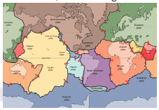
The largest of all plates is _____ plate.- a)Eurasian
- b)North American
- c)Pacific
- d)None of these
Correct answer is option 'C'. Can you explain this answer?
The largest of all plates is _____ plate.
a)
Eurasian
b)
North American
c)
Pacific
d)
None of these
|
|
Vaibhav Chauhan answered |
Explanation: The Pacific Plate is an oceanic tectonic plate that lies beneath the Pacific Ocean. At 103 million square kilometers, it is the largest tectonic plate.
The deepest part of Ocean is:- a)Mariana Trench
- b)Isle Trench
- c)Sunda Trench
- d)Puerto Rico Trench
Correct answer is option 'A'. Can you explain this answer?
The deepest part of Ocean is:
a)
Mariana Trench
b)
Isle Trench
c)
Sunda Trench
d)
Puerto Rico Trench
|
|
Surbhi answered |
The marina trench is located in the western pacific ocean about 200 kms east of the marina islands and have the deepest natural trench in the world...

Consider the following statements about forests soils :
1. They are rich in humus
2. They are deficient in phosphorous and potash
Which of the statements given above is/are correct ?
- a)1 only
- b)2 only
- c)Neither 1 nor 2
- d)Both 1 and 2
Correct answer is option 'D'. Can you explain this answer?
Consider the following statements about forests soils :
1. They are rich in humus
2. They are deficient in phosphorous and potash
Which of the statements given above is/are correct ?
a)
1 only
b)
2 only
c)
Neither 1 nor 2
d)
Both 1 and 2
|
|
Akash Majumdar answered |
Explanation:
1. Rich in humus:
- Forest soils are typically rich in organic matter, including humus, which is formed from the decomposition of plant and animal materials.
- Humus helps to improve soil structure, fertility, and moisture retention, making forest soils ideal for supporting diverse plant and animal life.
2. Deficient in phosphorous and potash:
- While forest soils are generally nutrient-rich due to the presence of organic matter, they can be deficient in certain essential nutrients like phosphorous and potash.
- Phosphorous and potash are important for plant growth and development, and their deficiency can limit the productivity of forest ecosystems.
Conclusion:
Both statements are correct. Forest soils are rich in humus but may be deficient in phosphorous and potash, highlighting the importance of nutrient management in forest ecosystems.
Which among the following is known as ” Doctor Wind”?- a)Loo
- b)Chinook
- c)Harmattan
- d)None of the above
Correct answer is option 'C'. Can you explain this answer?
Which among the following is known as ” Doctor Wind”?
a)
Loo
b)
Chinook
c)
Harmattan
d)
None of the above
|
|
Aravind Basu answered |
Answer: c
Explanation: The Harmattan is a dry and dusty northeasterly trade wind which blows from the Sahara Desert over the West African subcontinent into the Gulf of Guinea between the end of November and the middle of March (winter)
Which is/are the country/s in the world to use Gross National Happiness to measure the progress of the country?Consider the countries.
1) India.
2) Bangladesh.
3) Sweden.
4) Bhutan.Choose the country/s from the code below.- a)1, 4 only.
- b)2, 4 only.
- c)3 only.
- d)4 only.
Correct answer is option 'D'. Can you explain this answer?
Which is/are the country/s in the world to use Gross National Happiness to measure the progress of the country?
Consider the countries.
1) India.
2) Bangladesh.
3) Sweden.
4) Bhutan.
1) India.
2) Bangladesh.
3) Sweden.
4) Bhutan.
Choose the country/s from the code below.
a)
1, 4 only.
b)
2, 4 only.
c)
3 only.
d)
4 only.
|
|
Ankit Mathur answered |
4
Which one of the following pairs (Dam / Lake River) is not correctly matched?
- a)Govind Sagar - Satluj
- b)Wular Lake - Jhelum
- c)Ukai Reservoir - Tapi
- d)Kolleru Lake - Krishna
Correct answer is option 'D'. Can you explain this answer?
Which one of the following pairs (Dam / Lake River) is not correctly matched?
a)
Govind Sagar - Satluj
b)
Wular Lake - Jhelum
c)
Ukai Reservoir - Tapi
d)
Kolleru Lake - Krishna
|
|
Meera Menon answered |
Explanation:
The correct answer is option D, Wular Lake - Jhelum.
Wular Lake
Wular Lake is a large freshwater lake located in the Indian state of Jammu and Kashmir. It is one of the largest freshwater lakes in Asia and is situated between the cities of Srinagar and Bandipora. The lake is fed by the Jhelum River and other smaller rivers and streams.
Jhelum River
The Jhelum River is a major river in the Indian subcontinent, flowing through the Indian-administered territory of Jammu and Kashmir. It originates from the Verinag Spring in the Kashmir Valley and flows through the cities of Srinagar and Baramulla before entering Pakistan. In Pakistan, it merges with the Chenab River to form the Indus River.
Explanation of the Incorrect Pair
The pair Wular Lake - Jhelum is not correctly matched because Wular Lake is actually fed by the Jhelum River and not the other way around. The Jhelum River is the upstream source of water for Wular Lake, and the lake serves as a reservoir for the river.
Correctly Matched Pairs
a) Govind Sagar - Satluj: This pair is correctly matched. Govind Sagar is a reservoir located on the Satluj River in Himachal Pradesh, India. The reservoir was created by the Bhakra Dam, which is built on the Satluj River.
b) Kolleru Lake - Krishna: This pair is correctly matched. Kolleru Lake is a freshwater lake located in the Indian state of Andhra Pradesh. It is situated between the Krishna and Godavari River basins and is fed by the Krishna River.
c) Ukai Reservoir - Tapi: This pair is correctly matched. Ukai Reservoir is located on the Tapi River in the Indian state of Gujarat. It is one of the largest reservoirs in Gujarat and is used for irrigation, power generation, and drinking water supply.
Conclusion
In conclusion, the pair Wular Lake - Jhelum is not correctly matched because Wular Lake is fed by the Jhelum River and not the other way around. The other pairs - Govind Sagar - Satluj, Kolleru Lake - Krishna, and Ukai Reservoir - Tapi - are correctly matched.
Coal bed methane is released during coal mining and is generally recommended to extract it rather
than letting it evaporate into the atmosphere when untapped because
1. CBM if is not extracted can cause fire hazards while mining deep areas.
2. CBM if allowed to escape into atmosphere, will get converted into carbon monoxide which is a potent green house gas.Which of the statements is/are the correct reason/s?- a)1 only.
- b)2 only.
- c)Neither 1 nor 2.
- d)Both 1 and 2.
Correct answer is option 'B'. Can you explain this answer?
Coal bed methane is released during coal mining and is generally recommended to extract it rather
than letting it evaporate into the atmosphere when untapped because
1. CBM if is not extracted can cause fire hazards while mining deep areas.
2. CBM if allowed to escape into atmosphere, will get converted into carbon monoxide which is a potent green house gas.
than letting it evaporate into the atmosphere when untapped because
1. CBM if is not extracted can cause fire hazards while mining deep areas.
2. CBM if allowed to escape into atmosphere, will get converted into carbon monoxide which is a potent green house gas.
Which of the statements is/are the correct reason/s?
a)
1 only.
b)
2 only.
c)
Neither 1 nor 2.
d)
Both 1 and 2.

|
Suraj Lolage answered |
Option -B
Atoll refers to- a)A narrow strip of land separating two seas
- b)A hill top
- c)A strait joining two-seas
- d)A horse-shoe or ring-shaped coral reef
Correct answer is option 'D'. Can you explain this answer?
Atoll refers to
a)
A narrow strip of land separating two seas
b)
A hill top
c)
A strait joining two-seas
d)
A horse-shoe or ring-shaped coral reef
|
|
Rishabh Sen answered |
Explanation: An atoll is a ring-shaped coral reef, island, or series of islets. An atoll surrounds a body of water called a lagoon. Sometimes, atolls and lagoons protect a central island. Channels between islets connect a lagoon to the Open Ocean or sea.
In which one of the following States has India’s largest private sector sea port been commissioned recently?- a)Andhra Pradesh
- b)Karnataka
- c)Kerala
- d)Tamil Nadu
Correct answer is option 'A'. Can you explain this answer?
In which one of the following States has India’s largest private sector sea port been commissioned recently?
a)
Andhra Pradesh
b)
Karnataka
c)
Kerala
d)
Tamil Nadu
|
|
Sanvi Kapoor answered |
The correct option is A.
Andhra Pradesh State has India's largest private sector sea port which is been commissioned recently.
Andhra Pradesh State has India's largest private sector sea port which is been commissioned recently.
Ragi, a millet is currently encouraged to include in the diet to supplement nutrients to counter the malnutrition that is haunting the country.Consider the following statements Ragi.1) Ragi is rich in iron, calcium, roughage and is mainly grown in dry regions.2) Among minor producers Sikkim, Arunachal Pradesh, Uttarakhand are included.3) It is grown as a major crop in Bengaluru-Mysuru table land from where the country’s majority of Ragi production comes fromChoose the correct statements from the code below.a)1, 2 only.b)2, 3 only.c)1, 3 only.d)All the above.Correct answer is option 'D'. Can you explain this answer?
|
|
Neha Joshi answered |
In most countries, only national or federal government can constitute national parks, but inIndia, state governments have the power to constitute national parks. In fact, national parks can only be constituted or abolished through state legislation, whereas wild sanctuaries are created through an order of a competent authority, who can be the chief conservator of forests or a minister of a state. Thus, it is evident that national parks have greater degree of permanency than a wildlife sanctuary
What does 'Roaring forties' refer to?
- a)The tract of stormy westerly winds between latitudes 20-30o
- b)Whirl winds caused in Atlantic Ocean
- c)The region between latitudes 40º and 50ºS where the prevailing westerly winds blow over the open oceans with great regularity and strength
- d)None of these
Correct answer is option 'C'. Can you explain this answer?
What does 'Roaring forties' refer to?
a)
The tract of stormy westerly winds between latitudes 20-30o
b)
Whirl winds caused in Atlantic Ocean
c)
The region between latitudes 40º and 50ºS where the prevailing westerly winds blow over the open oceans with great regularity and strength
d)
None of these
|
|
Sagar Nair answered |
Explanation: The Roaring Forties are strong westerly winds found in the Southern Hemisphere, generally between the latitudes of 40 and 50 degrees.
Consider the following towns:
1. Karachi
2. Dhaka
3. Mandalay
4. Jodhpur
Which of the following is the correct order of the towns from north to south ?
- a)4 1 2 3
- b)4 3 2 1
- c)1 2 3 4
- d)4 2 3 1
Correct answer is option 'A'. Can you explain this answer?
Consider the following towns:
1. Karachi
2. Dhaka
3. Mandalay
4. Jodhpur
Which of the following is the correct order of the towns from north to south ?
a)
4 1 2 3
b)
4 3 2 1
c)
1 2 3 4
d)
4 2 3 1
|
|
Saanvi Mehta answered |
To accurately determine the order from north to south, we should verify the latitudes once more:
- Mandalay, Myanmar: Latitude approximately 21.98° N
- Dhaka, Bangladesh: Latitude approximately 23.81° N
- Karachi, Pakistan: Latitude approximately 24.86° N
- Jodhpur, India: Latitude approximately 26.29° N
Correct order from north to south:
- Jodhpur (26.29° N) - The northernmost town.
- Karachi (24.86° N) - Further south than Jodhpur but north of Dhaka.
- Dhaka (23.81° N) - Further south than Karachi.
- Mandalay (21.98° N) - The southernmost town.
So, the correct order from north to south is:
- Jodhpur
- Karachi
- Dhaka
- Mandalay
Which one of the following latitudinal extent is relevant for the extent of India’s area?- a)8°41'N - 35°7'N
- b)8°4'N - 35°6'N
- c)8°4'N - 37°6'N
- d)6°45'N - 37°6'N
Correct answer is option 'D'. Can you explain this answer?
Which one of the following latitudinal extent is relevant for the extent of India’s area?
a)
8°41'N - 35°7'N
b)
8°4'N - 35°6'N
c)
8°4'N - 37°6'N
d)
6°45'N - 37°6'N
|
|
Ravi Sharma answered |
The main land of India extends from 8° 4' 28" N to 37° 6' 53" N latitudes and from 68° 7' 53" E to 97° 24' 47" E longitudes. The latitudinal and longitudinal extent of India is approximately the same i.e. 30 degrees
Which one of the following rivers is not included in ‘Panchnad’?- a)The Ravi
- b)The Indus
- c)The Chenab
- d)The Jhelum
Correct answer is option 'B'. Can you explain this answer?
Which one of the following rivers is not included in ‘Panchnad’?
a)
The Ravi
b)
The Indus
c)
The Chenab
d)
The Jhelum
|
|
Surbhi Basu answered |
Answer: b
The Indus River flows southward and receives ‘Panjnad’ a little above Mithankot. The Panjnad is the name given to the five rivers of Punjab, namely the Satluj, the Beas, the Ravi, the Chenab and the Jhelum. It finally discharges into the Arabian Sea, east of Karachi.
Salinity is expressed as the amount of salt in grams dissolved in sea water per- a)10 gm
- b)1,000 gm
- c)100 gm
- d)10,000 gm
Correct answer is option 'B'. Can you explain this answer?
Salinity is expressed as the amount of salt in grams dissolved in sea water per
a)
10 gm
b)
1,000 gm
c)
100 gm
d)
10,000 gm
|
|
Vaibhav Chauhan answered |
Explanation: Salinity is the term used to define the total content of dissolved salts in sea water (Table 13.4). It is calculated as the amount of salt (in gm) dissolved in 1,000 gm (1 kg) of seawater. It is usually expressed as parts per thousand (o/oo) or ppt.
The International Date-line passes through the:- a)Bering Strait
- b)Florida Strait
- c)Gibraltar Strait
- d)Malacca Strait
Correct answer is option 'A'. Can you explain this answer?
The International Date-line passes through the:
a)
Bering Strait
b)
Florida Strait
c)
Gibraltar Strait
d)
Malacca Strait
|
|
S R Khan answered |
The International Date Line passes through the Bering Strait between the Diomede Island.
Chapter doubts & questions for Topic-wise Tests - Geography (Prelims) by Valor Academy 2025 is part of UPSC CSE exam preparation. The chapters have been prepared according to the UPSC CSE exam syllabus. The Chapter doubts & questions, notes, tests & MCQs are made for UPSC CSE 2025 Exam. Find important definitions, questions, notes, meanings, examples, exercises, MCQs and online tests here.
Chapter doubts & questions of Topic-wise Tests - Geography (Prelims) by Valor Academy in English & Hindi are available as part of UPSC CSE exam.
Download more important topics, notes, lectures and mock test series for UPSC CSE Exam by signing up for free.
Geography (Prelims) by Valor Academy
47 videos|185 docs|161 tests
|
|
© EduRev
|
Education Revolution
|


|


Signup to see your scores
go up within 7 days!
Access 1000+ FREE Docs, Videos and Tests
Takes less than 10 seconds to signup