


All Exams >
Humanities/Arts >
Geography Class 11 >
All Questions
All questions of Climate for Humanities/Arts Exam
Which place in India receives lowest rainfall?- a)Leh
- b)Jaisalmer
- c)Bikaner
- d)Jodhpur
Correct answer is option 'A'. Can you explain this answer?
Which place in India receives lowest rainfall?
a)
Leh
b)
Jaisalmer
c)
Bikaner
d)
Jodhpur
|
|
Athul Ghosh answered |
Leh is a cold area. Only snowfall occurs here.

What is the cause of climatic difference in Agra and Darjeeling?- a)Latitude
- b)Altitude
- c)Distance from the sea
- d)The Himalayan Mountains
Correct answer is option 'B'. Can you explain this answer?
What is the cause of climatic difference in Agra and Darjeeling?
a)
Latitude
b)
Altitude
c)
Distance from the sea
d)
The Himalayan Mountains
|
|
Aniket Banerjee answered |
Agra and Darjeeling are located on the same latitude, but temperature of January in Agra is 16°C whereas it is only 4°C in Darjeeling. It is due to the altitude difference. Temperature decreases with height. Due to thin air, places in the mountains are cooler than places on the plains.
Deccan plateau comes under area of- a)inadequate rainfall.
- b)high rainfall.
- c)medium rainfall.
- d)low rainfall.
Correct answer is option 'D'. Can you explain this answer?
Deccan plateau comes under area of
a)
inadequate rainfall.
b)
high rainfall.
c)
medium rainfall.
d)
low rainfall.
|
|
Meera Singh answered |
There is heavy rainfall on the western coast of India but very little in the Deccan because the Deccan plateau is situated in the rain shadow of the Western Ghats. The Deccan Plateau to the east of the Western Ghats receives significantly less rainfall than the coasts. As the summer (wet) monsoons approach the West Coast of India, they rise up the western Ghats (mountains) and the air cools. This cool air is less able to hold moisture and it is released as rainfall.
October is hot due to- a)the absence of rain.
- b)combination of high temperature and high humidity.
- c)dry hot weather.
- d)low pressure.
Correct answer is option 'B'. Can you explain this answer?
October is hot due to
a)
the absence of rain.
b)
combination of high temperature and high humidity.
c)
dry hot weather.
d)
low pressure.
|
|
Harsh Roy answered |
October is hot due to combination of high temperature and high humidity.
The dreaded evening thunderstorms in West Bengal are locally known as- a)Loo.
- b)Kalbaisakhi.
- c)Chheerha.
- d)Mango Shower.
Correct answer is option 'B'. Can you explain this answer?
The dreaded evening thunderstorms in West Bengal are locally known as
a)
Loo.
b)
Kalbaisakhi.
c)
Chheerha.
d)
Mango Shower.
|
|
Arjun Chaudhary answered |
The dreaded evening thunderstorms in Bengal are known as ‘Kalbaisakhi’, a calamity of the month of Baisakh.
Which one of the following states suffers from loo?- a)Tamil Nadu
- b)Assam
- c)Gujarat
- d)None of these
Correct answer is option 'C'. Can you explain this answer?
Which one of the following states suffers from loo?
a)
Tamil Nadu
b)
Assam
c)
Gujarat
d)
None of these
|
|
Abhigyan Gupta answered |
Gujrat, winds blow in summers with sand in Thar desert are called loo.
Direction: Read the case study given below and answer any three of the questions that follow.The average annual rainfall in India is about 125 cm, but it has great spatial variations.Areas of High Rainfall: The highest rainfall occurs along the west coast, on the Western Ghats, as well as in the sub-Himalayan areas is the northeast and the hills of Meghalaya. Here the rainfall exceeds 200 cm. In some parts of Khasi and Jaintia hills, the rainfall exceeds 1,000 cm. In the Brahmaputra valley and the adjoining hills, the rainfall is less than 200 cm.Areas of Medium Rainfall: Rainfall between 100-200 cm is received in the southern parts of Gujarat, East Tamil Nadu, north eastern Peninsula covering Odisha, Jharkhand, Bihar, eastern Madhya Pradesh, northern Ganga plain along the subHimalayas and the Cachar Valley and Manipur.Areas of Low Rainfall: Western Uttar Pradesh, Delhi, Haryana, Punjab, Jammu and Kashmir, eastern Rajasthan, Gujarat and Deccan Plateau receive rainfall between 50-100 cm.Areas of Inadequate Rainfall: Parts of the Peninsula, especially in Andhra Pradesh, Karnataka and Maharashtra, Ladakh and most of western Rajasthan receive rainfall below 50 cm. Snowfall is restricted to the Himalayan region.Q. How much rainfall does the Brahmaputra valley receive?- a)More than 200 cm
- b)Less than 200 cm
- c)More than 300 cm
- d)Less than 300 cm
Correct answer is option 'B'. Can you explain this answer?
Direction: Read the case study given below and answer any three of the questions that follow.
The average annual rainfall in India is about 125 cm, but it has great spatial variations.
Areas of High Rainfall: The highest rainfall occurs along the west coast, on the Western Ghats, as well as in the sub-Himalayan areas is the northeast and the hills of Meghalaya. Here the rainfall exceeds 200 cm. In some parts of Khasi and Jaintia hills, the rainfall exceeds 1,000 cm. In the Brahmaputra valley and the adjoining hills, the rainfall is less than 200 cm.
Areas of Medium Rainfall: Rainfall between 100-200 cm is received in the southern parts of Gujarat, East Tamil Nadu, north eastern Peninsula covering Odisha, Jharkhand, Bihar, eastern Madhya Pradesh, northern Ganga plain along the subHimalayas and the Cachar Valley and Manipur.
Areas of Low Rainfall: Western Uttar Pradesh, Delhi, Haryana, Punjab, Jammu and Kashmir, eastern Rajasthan, Gujarat and Deccan Plateau receive rainfall between 50-100 cm.
Areas of Inadequate Rainfall: Parts of the Peninsula, especially in Andhra Pradesh, Karnataka and Maharashtra, Ladakh and most of western Rajasthan receive rainfall below 50 cm. Snowfall is restricted to the Himalayan region.
Q. How much rainfall does the Brahmaputra valley receive?
a)
More than 200 cm
b)
Less than 200 cm
c)
More than 300 cm
d)
Less than 300 cm
|
|
Kiran Mehta answered |
The Brahmaputra basin receives an average of just over 1,100 mm (Less than 200 cm) of rain annually. Of the annual total, 70% is received during the monsoon season (June– September) and 20% in the pre-monsoon season.
According to Koppen's scheme of climatic regions the monsoon with short dry season is represented by- a)As.
- b)Cwg.
- c)Amw.
- d)Aw.
Correct answer is option 'C'. Can you explain this answer?
According to Koppen's scheme of climatic regions the monsoon with short dry season is represented by
a)
As.
b)
Cwg.
c)
Amw.
d)
Aw.
|
|
Avi Kapoor answered |
According to Koppen's scheme of climatic regions the monsoon with short dry season is represented by Amw.
Direction: Read the case study given below and answer any three of the questions that follow.The months of October and November are known for retreating monsoons. By the end of September, the southwest monsoon becomes weak as the low-pressure trough of the Ganga plain starts moving southward in response to the southward march of the sun. The monsoon retreats from the western Rajasthan by the first week of September. It withdraws from Rajasthan, Gujarat, Western Ganga plain and the Central Highlands by the end of the month. By the beginning of October, the low pressure covers northern parts of the Bay of Bengal and by early November, it moves over Karnataka and Tamil Nadu. By the middle of December, the centre of low pressure is completely removed from the Peninsula. The retreating southwest monsoon season is marked by clear skies and rise in temperature. The land is still moist. Owing to the conditions of high temperature and humidity, the weather becomes rather oppressive. This is commonly known as the ‘October heat’. In the second half of October, the mercury begins to fall rapidly, particularly in northern India. The weather in the retreating monsoon is dry in north India but it is associated with rain in the eastern part of the Peninsula. Here, October and November are the rainiest months of the year. The widespread rain in this season is associated with the passage of cyclonic depressions which originate over the Andaman Sea and manage to cross the eastern coast of the southern Peninsula. These tropical cyclones are very destructive. The thickly populated deltas of the Godavari, Krishna and Kaveri are their preferred targets. Every year cyclones bring disaster here. A few cyclonic storms also strike the coast of West Bengal, Bangladesh and Myanmar. A bulk of the rainfall of the Coromandel coast is derived from these depressions and cyclones. Such cyclonic storms are less frequent in the Arabian Sea.Q. The months of October and November are known for __________ monsoons.- a)southwest
- b)retreating
- c)cyclonic
- d)northwest
Correct answer is option 'B'. Can you explain this answer?
Direction: Read the case study given below and answer any three of the questions that follow.
The months of October and November are known for retreating monsoons. By the end of September, the southwest monsoon becomes weak as the low-pressure trough of the Ganga plain starts moving southward in response to the southward march of the sun. The monsoon retreats from the western Rajasthan by the first week of September. It withdraws from Rajasthan, Gujarat, Western Ganga plain and the Central Highlands by the end of the month. By the beginning of October, the low pressure covers northern parts of the Bay of Bengal and by early November, it moves over Karnataka and Tamil Nadu. By the middle of December, the centre of low pressure is completely removed from the Peninsula. The retreating southwest monsoon season is marked by clear skies and rise in temperature. The land is still moist. Owing to the conditions of high temperature and humidity, the weather becomes rather oppressive. This is commonly known as the ‘October heat’. In the second half of October, the mercury begins to fall rapidly, particularly in northern India. The weather in the retreating monsoon is dry in north India but it is associated with rain in the eastern part of the Peninsula. Here, October and November are the rainiest months of the year. The widespread rain in this season is associated with the passage of cyclonic depressions which originate over the Andaman Sea and manage to cross the eastern coast of the southern Peninsula. These tropical cyclones are very destructive. The thickly populated deltas of the Godavari, Krishna and Kaveri are their preferred targets. Every year cyclones bring disaster here. A few cyclonic storms also strike the coast of West Bengal, Bangladesh and Myanmar. A bulk of the rainfall of the Coromandel coast is derived from these depressions and cyclones. Such cyclonic storms are less frequent in the Arabian Sea.
Q. The months of October and November are known for __________ monsoons.
a)
southwest
b)
retreating
c)
cyclonic
d)
northwest
|
|
Arun Yadav answered |
The months of October and November are known for Retreating monsoon season.
Dry winter is experienced in the- a)Ganga plain.
- b)Eastern Ghats.
- c)Western Ghats.
- d)Deccan Plateau.
Correct answer is option 'A'. Can you explain this answer?
Dry winter is experienced in the
a)
Ganga plain.
b)
Eastern Ghats.
c)
Western Ghats.
d)
Deccan Plateau.
|
|
Rishabh Sengupta answered |
In winters, the northwestern parts of the subcontinent attracts wind from the Meditteranean region in the form of westerly disturbances. After September, retreating monsoons move out of the Ganga plains towards the low pressure zone of Bay of Bengal. They gather moisture from the bay and are drawn towards another low-pressure zone in the southern peninsula.
Where do you experience a dry winter?- a)The Ganga plain
- b)North-eastern India
- c)Kashmir
- d)Coromandal coast
Correct answer is option 'A'. Can you explain this answer?
Where do you experience a dry winter?
a)
The Ganga plain
b)
North-eastern India
c)
Kashmir
d)
Coromandal coast
|
|
Varun Chauhan answered |
There is no or very little precipitation during winters.
Which type of climate is found in Coromandel coast?- a)Amw
- b)Bwhw
- c)Cwg
- d)As
Correct answer is option 'D'. Can you explain this answer?
Which type of climate is found in Coromandel coast?
a)
Amw
b)
Bwhw
c)
Cwg
d)
As
|
|
Krish Sharma answered |
Coromandel coast of Tamil Nadu is chracterised by As type of climate. This climatic region has Monsoon with dry summer.
Direction: Read the case study given below and answer any three of the questions that follow.The temperature of the world is significantly increasing. Carbon dioxide produced by human activities is a major source of concern. This gas, released to the atmosphere in large quantities by burning of fossil fuel, is increasing gradually. Other gases like methane, chlorofluorocarbons, and nitrous oxide which are present in much smaller concentrations in the atmosphere, together with carbon dioxide are known as greenhouse gases. These gases are better absorbers of long wave radiations than carbon dioxide, and so, are more effective at enhancing the greenhouse effect. These gases have been contributing to global warming. It is said that due to global warming the polar ice caps and mountain glaciers would melt and the amount of water in the oceans would increase. The mean annual surface temperature of the earth in the past 150 years has increased. It is projected that by the year 2,100, global temperature will increase by about 2°C. This rise in temperature will cause many other changes: one of these is arise in sea level, as a result of melting of glaciers and sea-ice due to warming. According to the current prediction, on an average, the sea level will rise 48 cm by the end of twenty first century. This would increase the incidence of annual flooding. Climatic change would promote insect-borne diseases like malaria, and lead to shift in climatic boundaries, making some regions wetter and others drier. Agricultural pattern would shift and human population as well as the ecosystem would experience change.Q. What would lead to shifts in agricultural patterns and the ecosystem?- a)Climatic drift
- b)Climatic change
- c)Climate variation
- d)None of the above
Correct answer is option 'B'. Can you explain this answer?
Direction: Read the case study given below and answer any three of the questions that follow.
The temperature of the world is significantly increasing. Carbon dioxide produced by human activities is a major source of concern. This gas, released to the atmosphere in large quantities by burning of fossil fuel, is increasing gradually. Other gases like methane, chlorofluorocarbons, and nitrous oxide which are present in much smaller concentrations in the atmosphere, together with carbon dioxide are known as greenhouse gases. These gases are better absorbers of long wave radiations than carbon dioxide, and so, are more effective at enhancing the greenhouse effect. These gases have been contributing to global warming. It is said that due to global warming the polar ice caps and mountain glaciers would melt and the amount of water in the oceans would increase. The mean annual surface temperature of the earth in the past 150 years has increased. It is projected that by the year 2,100, global temperature will increase by about 2°C. This rise in temperature will cause many other changes: one of these is arise in sea level, as a result of melting of glaciers and sea-ice due to warming. According to the current prediction, on an average, the sea level will rise 48 cm by the end of twenty first century. This would increase the incidence of annual flooding. Climatic change would promote insect-borne diseases like malaria, and lead to shift in climatic boundaries, making some regions wetter and others drier. Agricultural pattern would shift and human population as well as the ecosystem would experience change.
Q. What would lead to shifts in agricultural patterns and the ecosystem?
a)
Climatic drift
b)
Climatic change
c)
Climate variation
d)
None of the above
|
|
Arun Yadav answered |
Agriculture contributes towards climate change through anthropogenic greenhouse gas emissions and by the conversion of non-agricultural land such as forests into agricultural land. In 2010, agriculture, forestry and land-use change were estimated to contribute 20–25% of global annual emissions.
Direction: Read the case study given below and answer any three of the questions that follow.The average annual rainfall in India is about 125 cm, but it has great spatial variations.Areas of High Rainfall: The highest rainfall occurs along the west coast, on the Western Ghats, as well as in the sub-Himalayan areas is the northeast and the hills of Meghalaya. Here the rainfall exceeds 200 cm. In some parts of Khasi and Jaintia hills, the rainfall exceeds 1,000 cm. In the Brahmaputra valley and the adjoining hills, the rainfall is less than 200 cm.Areas of Medium Rainfall: Rainfall between 100-200 cm is received in the southern parts of Gujarat, East Tamil Nadu, north eastern Peninsula covering Odisha, Jharkhand, Bihar, eastern Madhya Pradesh, northern Ganga plain along the subHimalayas and the Cachar Valley and Manipur.Areas of Low Rainfall: Western Uttar Pradesh, Delhi, Haryana, Punjab, Jammu and Kashmir, eastern Rajasthan, Gujarat and Deccan Plateau receive rainfall between 50-100 cm.Areas of Inadequate Rainfall: Parts of the Peninsula, especially in Andhra Pradesh, Karnataka and Maharashtra, Ladakh and most of western Rajasthan receive rainfall below 50 cm. Snowfall is restricted to the Himalayan region.Q. What is the average rainfall received in India?- a)121 cm
- b)125 cm
- c)130 cm
- d)135 cm
Correct answer is option 'B'. Can you explain this answer?
Direction: Read the case study given below and answer any three of the questions that follow.
The average annual rainfall in India is about 125 cm, but it has great spatial variations.
Areas of High Rainfall: The highest rainfall occurs along the west coast, on the Western Ghats, as well as in the sub-Himalayan areas is the northeast and the hills of Meghalaya. Here the rainfall exceeds 200 cm. In some parts of Khasi and Jaintia hills, the rainfall exceeds 1,000 cm. In the Brahmaputra valley and the adjoining hills, the rainfall is less than 200 cm.
Areas of Medium Rainfall: Rainfall between 100-200 cm is received in the southern parts of Gujarat, East Tamil Nadu, north eastern Peninsula covering Odisha, Jharkhand, Bihar, eastern Madhya Pradesh, northern Ganga plain along the subHimalayas and the Cachar Valley and Manipur.
Areas of Low Rainfall: Western Uttar Pradesh, Delhi, Haryana, Punjab, Jammu and Kashmir, eastern Rajasthan, Gujarat and Deccan Plateau receive rainfall between 50-100 cm.
Areas of Inadequate Rainfall: Parts of the Peninsula, especially in Andhra Pradesh, Karnataka and Maharashtra, Ladakh and most of western Rajasthan receive rainfall below 50 cm. Snowfall is restricted to the Himalayan region.
Q. What is the average rainfall received in India?
a)
121 cm
b)
125 cm
c)
130 cm
d)
135 cm
|
|
Kiran Mehta answered |
The average rainfall in India is 125 cm.
Direction: Read the case study given below and answer any three of the questions that follow.The average annual rainfall in India is about 125 cm, but it has great spatial variations.Areas of High Rainfall: The highest rainfall occurs along the west coast, on the Western Ghats, as well as in the sub-Himalayan areas is the northeast and the hills of Meghalaya. Here the rainfall exceeds 200 cm. In some parts of Khasi and Jaintia hills, the rainfall exceeds 1,000 cm. In the Brahmaputra valley and the adjoining hills, the rainfall is less than 200 cm.Areas of Medium Rainfall: Rainfall between 100-200 cm is received in the southern parts of Gujarat, East Tamil Nadu, north eastern Peninsula covering Odisha, Jharkhand, Bihar, eastern Madhya Pradesh, northern Ganga plain along the subHimalayas and the Cachar Valley and Manipur.Areas of Low Rainfall: Western Uttar Pradesh, Delhi, Haryana, Punjab, Jammu and Kashmir, eastern Rajasthan, Gujarat and Deccan Plateau receive rainfall between 50-100 cm.Areas of Inadequate Rainfall: Parts of the Peninsula, especially in Andhra Pradesh, Karnataka and Maharashtra, Ladakh and most of western Rajasthan receive rainfall below 50 cm. Snowfall is restricted to the Himalayan region.Q. In some parts of Khasi and Jaintia hills, the rainfall exceeds:- a)1,000 cm
- b)2,000 cm
- c)3,000 cm
- d)4,000 cm
Correct answer is option 'A'. Can you explain this answer?
Direction: Read the case study given below and answer any three of the questions that follow.
The average annual rainfall in India is about 125 cm, but it has great spatial variations.
Areas of High Rainfall: The highest rainfall occurs along the west coast, on the Western Ghats, as well as in the sub-Himalayan areas is the northeast and the hills of Meghalaya. Here the rainfall exceeds 200 cm. In some parts of Khasi and Jaintia hills, the rainfall exceeds 1,000 cm. In the Brahmaputra valley and the adjoining hills, the rainfall is less than 200 cm.
Areas of Medium Rainfall: Rainfall between 100-200 cm is received in the southern parts of Gujarat, East Tamil Nadu, north eastern Peninsula covering Odisha, Jharkhand, Bihar, eastern Madhya Pradesh, northern Ganga plain along the subHimalayas and the Cachar Valley and Manipur.
Areas of Low Rainfall: Western Uttar Pradesh, Delhi, Haryana, Punjab, Jammu and Kashmir, eastern Rajasthan, Gujarat and Deccan Plateau receive rainfall between 50-100 cm.
Areas of Inadequate Rainfall: Parts of the Peninsula, especially in Andhra Pradesh, Karnataka and Maharashtra, Ladakh and most of western Rajasthan receive rainfall below 50 cm. Snowfall is restricted to the Himalayan region.
Q. In some parts of Khasi and Jaintia hills, the rainfall exceeds:
a)
1,000 cm
b)
2,000 cm
c)
3,000 cm
d)
4,000 cm
|
|
Arun Yadav answered |
The highest rainfall occurs along the west coast, on the Western Ghats, as well as in the sub-Himalayan areas is the northeast and the hills of Meghalaya. Here the rainfall exceeds 200 cm. In some parts of Khasi and Jaintia hills, the rainfall exceeds 1,000 cm.
Direction: Study the given graph of annual rain distribution in Tamil Nadu (2017) carefully and answer any three of the questions that follow :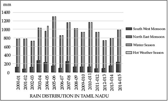 Q. Which year received the maximum rain from North East Monsoon?
- a)2003-04
- b)2005-06
- c)2007-08
- d)2010-11
Correct answer is option 'B'. Can you explain this answer?
Direction: Study the given graph of annual rain distribution in Tamil Nadu (2017) carefully and answer any three of the questions that follow :
Q. Which year received the maximum rain from North East Monsoon?
a)
2003-04
b)
2005-06
c)
2007-08
d)
2010-11
|
|
Kiran Mehta answered |
In 2005-06 we received the maximum rain from North East Monsoon.
Direction: Read the case study given below and answer any three of the questions that follow.The temperature of the world is significantly increasing. Carbon dioxide produced by human activities is a major source of concern. This gas, released to the atmosphere in large quantities by burning of fossil fuel, is increasing gradually. Other gases like methane, chlorofluorocarbons, and nitrous oxide which are present in much smaller concentrations in the atmosphere, together with carbon dioxide are known as greenhouse gases. These gases are better absorbers of long wave radiations than carbon dioxide, and so, are more effective at enhancing the greenhouse effect. These gases have been contributing to global warming. It is said that due to global warming the polar ice caps and mountain glaciers would melt and the amount of water in the oceans would increase. The mean annual surface temperature of the earth in the past 150 years has increased. It is projected that by the year 2,100, global temperature will increase by about 2°C. This rise in temperature will cause many other changes: one of these is arise in sea level, as a result of melting of glaciers and sea-ice due to warming. According to the current prediction, on an average, the sea level will rise 48 cm by the end of twenty first century. This would increase the incidence of annual flooding. Climatic change would promote insect-borne diseases like malaria, and lead to shift in climatic boundaries, making some regions wetter and others drier. Agricultural pattern would shift and human population as well as the ecosystem would experience change.Q. Methane, chlorofluorocarbons and nitrous oxide along with carbon dioxide is known as:- a)greenhouse gases
- b)combustion gases
- c)liquid gases
- d)solid gases
Correct answer is option 'A'. Can you explain this answer?
Direction: Read the case study given below and answer any three of the questions that follow.
The temperature of the world is significantly increasing. Carbon dioxide produced by human activities is a major source of concern. This gas, released to the atmosphere in large quantities by burning of fossil fuel, is increasing gradually. Other gases like methane, chlorofluorocarbons, and nitrous oxide which are present in much smaller concentrations in the atmosphere, together with carbon dioxide are known as greenhouse gases. These gases are better absorbers of long wave radiations than carbon dioxide, and so, are more effective at enhancing the greenhouse effect. These gases have been contributing to global warming. It is said that due to global warming the polar ice caps and mountain glaciers would melt and the amount of water in the oceans would increase. The mean annual surface temperature of the earth in the past 150 years has increased. It is projected that by the year 2,100, global temperature will increase by about 2°C. This rise in temperature will cause many other changes: one of these is arise in sea level, as a result of melting of glaciers and sea-ice due to warming. According to the current prediction, on an average, the sea level will rise 48 cm by the end of twenty first century. This would increase the incidence of annual flooding. Climatic change would promote insect-borne diseases like malaria, and lead to shift in climatic boundaries, making some regions wetter and others drier. Agricultural pattern would shift and human population as well as the ecosystem would experience change.
Q. Methane, chlorofluorocarbons and nitrous oxide along with carbon dioxide is known as:
a)
greenhouse gases
b)
combustion gases
c)
liquid gases
d)
solid gases
|
|
Arun Yadav answered |
Greenhouse gases (GHG) include carbon dioxide, water vapor, methane, ozone, nitrous oxide and fluorinated gases. These molecules in our atmosphere are called greenhouse gases because they absorb heat. Thus, greenhouse gases trap heat within the surface-troposphere system. This is called the greenhouse effect.
Direction: Read the case study given below and answer any three of the questions that follow.The average annual rainfall in India is about 125 cm, but it has great spatial variations.Areas of High Rainfall: The highest rainfall occurs along the west coast, on the Western Ghats, as well as in the sub-Himalayan areas is the northeast and the hills of Meghalaya. Here the rainfall exceeds 200 cm. In some parts of Khasi and Jaintia hills, the rainfall exceeds 1,000 cm. In the Brahmaputra valley and the adjoining hills, the rainfall is less than 200 cm.Areas of Medium Rainfall: Rainfall between 100-200 cm is received in the southern parts of Gujarat, East Tamil Nadu, north eastern Peninsula covering Odisha, Jharkhand, Bihar, eastern Madhya Pradesh, northern Ganga plain along the subHimalayas and the Cachar Valley and Manipur.Areas of Low Rainfall: Western Uttar Pradesh, Delhi, Haryana, Punjab, Jammu and Kashmir, eastern Rajasthan, Gujarat and Deccan Plateau receive rainfall between 50-100 cm.Areas of Inadequate Rainfall: Parts of the Peninsula, especially in Andhra Pradesh, Karnataka and Maharashtra, Ladakh and most of western Rajasthan receive rainfall below 50 cm. Snowfall is restricted to the Himalayan region.Q. How much rainfall does Punjab, Haryana and Delhi receive?- a)Between 40 – 80 cm
- b)Between 80- 100 cm
- c)Between 50-100 cm
- d)Between 100-150 cm
Correct answer is option 'C'. Can you explain this answer?
Direction: Read the case study given below and answer any three of the questions that follow.
The average annual rainfall in India is about 125 cm, but it has great spatial variations.
Areas of High Rainfall: The highest rainfall occurs along the west coast, on the Western Ghats, as well as in the sub-Himalayan areas is the northeast and the hills of Meghalaya. Here the rainfall exceeds 200 cm. In some parts of Khasi and Jaintia hills, the rainfall exceeds 1,000 cm. In the Brahmaputra valley and the adjoining hills, the rainfall is less than 200 cm.
Areas of Medium Rainfall: Rainfall between 100-200 cm is received in the southern parts of Gujarat, East Tamil Nadu, north eastern Peninsula covering Odisha, Jharkhand, Bihar, eastern Madhya Pradesh, northern Ganga plain along the subHimalayas and the Cachar Valley and Manipur.
Areas of Low Rainfall: Western Uttar Pradesh, Delhi, Haryana, Punjab, Jammu and Kashmir, eastern Rajasthan, Gujarat and Deccan Plateau receive rainfall between 50-100 cm.
Areas of Inadequate Rainfall: Parts of the Peninsula, especially in Andhra Pradesh, Karnataka and Maharashtra, Ladakh and most of western Rajasthan receive rainfall below 50 cm. Snowfall is restricted to the Himalayan region.
Q. How much rainfall does Punjab, Haryana and Delhi receive?
a)
Between 40 – 80 cm
b)
Between 80- 100 cm
c)
Between 50-100 cm
d)
Between 100-150 cm
|
|
Kiran Mehta answered |
Between 50-100 cm rainfall received by Punjab, Haryana and Delhi.
Direction: Read the case study given below and answer any three of the questions that follow.The months of October and November are known for retreating monsoons. By the end of September, the southwest monsoon becomes weak as the low-pressure trough of the Ganga plain starts moving southward in response to the southward march of the sun. The monsoon retreats from the western Rajasthan by the first week of September. It withdraws from Rajasthan, Gujarat, Western Ganga plain and the Central Highlands by the end of the month. By the beginning of October, the low pressure covers northern parts of the Bay of Bengal and by early November, it moves over Karnataka and Tamil Nadu. By the middle of December, the centre of low pressure is completely removed from the Peninsula. The retreating southwest monsoon season is marked by clear skies and rise in temperature. The land is still moist. Owing to the conditions of high temperature and humidity, the weather becomes rather oppressive. This is commonly known as the ‘October heat’. In the second half of October, the mercury begins to fall rapidly, particularly in northern India. The weather in the retreating monsoon is dry in north India but it is associated with rain in the eastern part of the Peninsula. Here, October and November are the rainiest months of the year. The widespread rain in this season is associated with the passage of cyclonic depressions which originate over the Andaman Sea and manage to cross the eastern coast of the southern Peninsula. These tropical cyclones are very destructive. The thickly populated deltas of the Godavari, Krishna and Kaveri are their preferred targets. Every year cyclones bring disaster here. A few cyclonic storms also strike the coast of West Bengal, Bangladesh and Myanmar. A bulk of the rainfall of the Coromandel coast is derived from these depressions and cyclones. Such cyclonic storms are less frequent in the Arabian Sea.Q. When do the Southwest monsoon start becoming weak?- a)End of September
- b)Starting of September
- c)End of October
- d)Starting of October
Correct answer is option 'A'. Can you explain this answer?
Direction: Read the case study given below and answer any three of the questions that follow.
The months of October and November are known for retreating monsoons. By the end of September, the southwest monsoon becomes weak as the low-pressure trough of the Ganga plain starts moving southward in response to the southward march of the sun. The monsoon retreats from the western Rajasthan by the first week of September. It withdraws from Rajasthan, Gujarat, Western Ganga plain and the Central Highlands by the end of the month. By the beginning of October, the low pressure covers northern parts of the Bay of Bengal and by early November, it moves over Karnataka and Tamil Nadu. By the middle of December, the centre of low pressure is completely removed from the Peninsula. The retreating southwest monsoon season is marked by clear skies and rise in temperature. The land is still moist. Owing to the conditions of high temperature and humidity, the weather becomes rather oppressive. This is commonly known as the ‘October heat’. In the second half of October, the mercury begins to fall rapidly, particularly in northern India. The weather in the retreating monsoon is dry in north India but it is associated with rain in the eastern part of the Peninsula. Here, October and November are the rainiest months of the year. The widespread rain in this season is associated with the passage of cyclonic depressions which originate over the Andaman Sea and manage to cross the eastern coast of the southern Peninsula. These tropical cyclones are very destructive. The thickly populated deltas of the Godavari, Krishna and Kaveri are their preferred targets. Every year cyclones bring disaster here. A few cyclonic storms also strike the coast of West Bengal, Bangladesh and Myanmar. A bulk of the rainfall of the Coromandel coast is derived from these depressions and cyclones. Such cyclonic storms are less frequent in the Arabian Sea.
Q. When do the Southwest monsoon start becoming weak?
a)
End of September
b)
Starting of September
c)
End of October
d)
Starting of October
|
|
Rajesh Gupta answered |
- End of September monsoon starts becoming weak.
- The southwest monsoon affects the country from late June to October (occurrence may also vary each year).
- Low season in the Philippines occurs during the habagat season because of frequent rainfall and high humidity.
- A series of flash floods and landslides are regular incidents during this season.
Direction: Study the given graph of annual rain distribution in Tamil Nadu (2017) carefully and answer any three of the questions that follow : Q. Which year received the minimum rain from the North East Monsoon?
- a)2000-01, 2014-15
- b)2002-03, 2012-13
- c)2005-06, 2002-03
- d)2007-08, 2005-06
Correct answer is option 'B'. Can you explain this answer?
Direction: Study the given graph of annual rain distribution in Tamil Nadu (2017) carefully and answer any three of the questions that follow :
Q. Which year received the minimum rain from the North East Monsoon?
a)
2000-01, 2014-15
b)
2002-03, 2012-13
c)
2005-06, 2002-03
d)
2007-08, 2005-06
|
|
Arun Yadav answered |
In 2002-03, 2012-13 we received the minimum rain from the North East Monsoon.
Direction: Read the case study given below and answer any three of the questions that follow.The temperature of the world is significantly increasing. Carbon dioxide produced by human activities is a major source of concern. This gas, released to the atmosphere in large quantities by burning of fossil fuel, is increasing gradually. Other gases like methane, chlorofluorocarbons, and nitrous oxide which are present in much smaller concentrations in the atmosphere, together with carbon dioxide are known as greenhouse gases. These gases are better absorbers of long wave radiations than carbon dioxide, and so, are more effective at enhancing the greenhouse effect. These gases have been contributing to global warming. It is said that due to global warming the polar ice caps and mountain glaciers would melt and the amount of water in the oceans would increase. The mean annual surface temperature of the earth in the past 150 years has increased. It is projected that by the year 2,100, global temperature will increase by about 2°C. This rise in temperature will cause many other changes: one of these is arise in sea level, as a result of melting of glaciers and sea-ice due to warming. According to the current prediction, on an average, the sea level will rise 48 cm by the end of twenty first century. This would increase the incidence of annual flooding. Climatic change would promote insect-borne diseases like malaria, and lead to shift in climatic boundaries, making some regions wetter and others drier. Agricultural pattern would shift and human population as well as the ecosystem would experience change.Q. Which gas is a better absorber of long wave radiations?- a)Carbon dioxide
- b)Methane
- c)Oxygen
- d)Helium
Correct answer is option 'B'. Can you explain this answer?
Direction: Read the case study given below and answer any three of the questions that follow.
The temperature of the world is significantly increasing. Carbon dioxide produced by human activities is a major source of concern. This gas, released to the atmosphere in large quantities by burning of fossil fuel, is increasing gradually. Other gases like methane, chlorofluorocarbons, and nitrous oxide which are present in much smaller concentrations in the atmosphere, together with carbon dioxide are known as greenhouse gases. These gases are better absorbers of long wave radiations than carbon dioxide, and so, are more effective at enhancing the greenhouse effect. These gases have been contributing to global warming. It is said that due to global warming the polar ice caps and mountain glaciers would melt and the amount of water in the oceans would increase. The mean annual surface temperature of the earth in the past 150 years has increased. It is projected that by the year 2,100, global temperature will increase by about 2°C. This rise in temperature will cause many other changes: one of these is arise in sea level, as a result of melting of glaciers and sea-ice due to warming. According to the current prediction, on an average, the sea level will rise 48 cm by the end of twenty first century. This would increase the incidence of annual flooding. Climatic change would promote insect-borne diseases like malaria, and lead to shift in climatic boundaries, making some regions wetter and others drier. Agricultural pattern would shift and human population as well as the ecosystem would experience change.
Q. Which gas is a better absorber of long wave radiations?
a)
Carbon dioxide
b)
Methane
c)
Oxygen
d)
Helium
|
|
Arun Yadav answered |
The atmosphere allows the heat from the Sun (short-wave radiation) to pass through to heat the Earth's surface. The Earth's surface then gives off heat (long-wave radiation). This heat is trapped by greenhouse gases (eg methane, carbon dioxide and nitrous oxide), which radiate the heat back towards Earth.
Direction: Read the case study given below and answer any three of the questions that follow.The months of October and November are known for retreating monsoons. By the end of September, the southwest monsoon becomes weak as the low-pressure trough of the Ganga plain starts moving southward in response to the southward march of the sun. The monsoon retreats from the western Rajasthan by the first week of September. It withdraws from Rajasthan, Gujarat, Western Ganga plain and the Central Highlands by the end of the month. By the beginning of October, the low pressure covers northern parts of the Bay of Bengal and by early November, it moves over Karnataka and Tamil Nadu. By the middle of December, the centre of low pressure is completely removed from the Peninsula. The retreating southwest monsoon season is marked by clear skies and rise in temperature. The land is still moist. Owing to the conditions of high temperature and humidity, the weather becomes rather oppressive. This is commonly known as the ‘October heat’. In the second half of October, the mercury begins to fall rapidly, particularly in northern India. The weather in the retreating monsoon is dry in north India but it is associated with rain in the eastern part of the Peninsula. Here, October and November are the rainiest months of the year. The widespread rain in this season is associated with the passage of cyclonic depressions which originate over the Andaman Sea and manage to cross the eastern coast of the southern Peninsula. These tropical cyclones are very destructive. The thickly populated deltas of the Godavari, Krishna and Kaveri are their preferred targets. Every year cyclones bring disaster here. A few cyclonic storms also strike the coast of West Bengal, Bangladesh and Myanmar. A bulk of the rainfall of the Coromandel coast is derived from these depressions and cyclones. Such cyclonic storms are less frequent in the Arabian Sea.Q. The retreating ___________ monsoon season is marked by clear skies and rise in temperature.- a)northeast
- b)southwest
- c)western
- d)None of the above
Correct answer is option 'A'. Can you explain this answer?
Direction: Read the case study given below and answer any three of the questions that follow.
The months of October and November are known for retreating monsoons. By the end of September, the southwest monsoon becomes weak as the low-pressure trough of the Ganga plain starts moving southward in response to the southward march of the sun. The monsoon retreats from the western Rajasthan by the first week of September. It withdraws from Rajasthan, Gujarat, Western Ganga plain and the Central Highlands by the end of the month. By the beginning of October, the low pressure covers northern parts of the Bay of Bengal and by early November, it moves over Karnataka and Tamil Nadu. By the middle of December, the centre of low pressure is completely removed from the Peninsula. The retreating southwest monsoon season is marked by clear skies and rise in temperature. The land is still moist. Owing to the conditions of high temperature and humidity, the weather becomes rather oppressive. This is commonly known as the ‘October heat’. In the second half of October, the mercury begins to fall rapidly, particularly in northern India. The weather in the retreating monsoon is dry in north India but it is associated with rain in the eastern part of the Peninsula. Here, October and November are the rainiest months of the year. The widespread rain in this season is associated with the passage of cyclonic depressions which originate over the Andaman Sea and manage to cross the eastern coast of the southern Peninsula. These tropical cyclones are very destructive. The thickly populated deltas of the Godavari, Krishna and Kaveri are their preferred targets. Every year cyclones bring disaster here. A few cyclonic storms also strike the coast of West Bengal, Bangladesh and Myanmar. A bulk of the rainfall of the Coromandel coast is derived from these depressions and cyclones. Such cyclonic storms are less frequent in the Arabian Sea.
Q. The retreating ___________ monsoon season is marked by clear skies and rise in temperature.
a)
northeast
b)
southwest
c)
western
d)
None of the above
|
|
Rajesh Gupta answered |
Monsoon retreat is marked by clear sky. North-east monsoon winds bring rainfall over the coastal region of Tamil Nadu while the retreating monsoon is marked by clear skies and rise in temperature.
Direction: Study the given graph of annual rain distribution in Tamil Nadu (2017) carefully and answer any three of the questions that follow : Q. The rainfall in the given graph is measured in:
- a)Centimetres
- b)Millimetres
- c)Kilometres
- d)None of the above
Correct answer is option 'B'. Can you explain this answer?
Direction: Study the given graph of annual rain distribution in Tamil Nadu (2017) carefully and answer any three of the questions that follow :
Q. The rainfall in the given graph is measured in:
a)
Centimetres
b)
Millimetres
c)
Kilometres
d)
None of the above
|
|
Rajesh Gupta answered |
The standard instrument for the measurement of rainfall is the 203mm (Millimetres) (8 inch) rain gauge. This is essentially a circular funnel with a diameter of 203mm which collects the rain into a graduated and calibrated cylinder. The measuring cylinder can record up to 25mm of precipitation.
Direction: Study the given graph of annual rain distribution in Tamil Nadu (2017) carefully and answer any three of the questions that follow : Q. Which year received 800 mm of rainfall from both Southwest and Northeast Monsoons?
- a)2000-01
- b)2001-02
- c)2012-13
- d)2013-14
Correct answer is option 'B'. Can you explain this answer?
Direction: Study the given graph of annual rain distribution in Tamil Nadu (2017) carefully and answer any three of the questions that follow :
Q. Which year received 800 mm of rainfall from both Southwest and Northeast Monsoons?
a)
2000-01
b)
2001-02
c)
2012-13
d)
2013-14
|
|
Kiran Mehta answered |
In 2001-02 we received 800 mm of rainfall from both Southwest and Northeast Monsoons.
Direction: Read the case study given below and answer any three of the questions that follow.The temperature of the world is significantly increasing. Carbon dioxide produced by human activities is a major source of concern. This gas, released to the atmosphere in large quantities by burning of fossil fuel, is increasing gradually. Other gases like methane, chlorofluorocarbons, and nitrous oxide which are present in much smaller concentrations in the atmosphere, together with carbon dioxide are known as greenhouse gases. These gases are better absorbers of long wave radiations than carbon dioxide, and so, are more effective at enhancing the greenhouse effect. These gases have been contributing to global warming. It is said that due to global warming the polar ice caps and mountain glaciers would melt and the amount of water in the oceans would increase. The mean annual surface temperature of the earth in the past 150 years has increased. It is projected that by the year 2,100, global temperature will increase by about 2°C. This rise in temperature will cause many other changes: one of these is arise in sea level, as a result of melting of glaciers and sea-ice due to warming. According to the current prediction, on an average, the sea level will rise 48 cm by the end of twenty first century. This would increase the incidence of annual flooding. Climatic change would promote insect-borne diseases like malaria, and lead to shift in climatic boundaries, making some regions wetter and others drier. Agricultural pattern would shift and human population as well as the ecosystem would experience change.Q. According to the current prediction, on an average, the sea level will rise __________ cm by the end of twenty-first century.- a)46
- b)48
- c)50
- d)52
Correct answer is option 'B'. Can you explain this answer?
Direction: Read the case study given below and answer any three of the questions that follow.
The temperature of the world is significantly increasing. Carbon dioxide produced by human activities is a major source of concern. This gas, released to the atmosphere in large quantities by burning of fossil fuel, is increasing gradually. Other gases like methane, chlorofluorocarbons, and nitrous oxide which are present in much smaller concentrations in the atmosphere, together with carbon dioxide are known as greenhouse gases. These gases are better absorbers of long wave radiations than carbon dioxide, and so, are more effective at enhancing the greenhouse effect. These gases have been contributing to global warming. It is said that due to global warming the polar ice caps and mountain glaciers would melt and the amount of water in the oceans would increase. The mean annual surface temperature of the earth in the past 150 years has increased. It is projected that by the year 2,100, global temperature will increase by about 2°C. This rise in temperature will cause many other changes: one of these is arise in sea level, as a result of melting of glaciers and sea-ice due to warming. According to the current prediction, on an average, the sea level will rise 48 cm by the end of twenty first century. This would increase the incidence of annual flooding. Climatic change would promote insect-borne diseases like malaria, and lead to shift in climatic boundaries, making some regions wetter and others drier. Agricultural pattern would shift and human population as well as the ecosystem would experience change.
Q. According to the current prediction, on an average, the sea level will rise __________ cm by the end of twenty-first century.
a)
46
b)
48
c)
50
d)
52
|
|
Arun Yadav answered |
According to the current prediction, on an average, the sea level will rise 48 cm by the end of twenty-first century.
Chapter doubts & questions for Climate - Geography Class 11 2025 is part of Humanities/Arts exam preparation. The chapters have been prepared according to the Humanities/Arts exam syllabus. The Chapter doubts & questions, notes, tests & MCQs are made for Humanities/Arts 2025 Exam. Find important definitions, questions, notes, meanings, examples, exercises, MCQs and online tests here.
Chapter doubts & questions of Climate - Geography Class 11 in English & Hindi are available as part of Humanities/Arts exam.
Download more important topics, notes, lectures and mock test series for Humanities/Arts Exam by signing up for free.
Geography Class 11
70 videos|289 docs|44 tests
|
|
© EduRev
|
Education Revolution
|


|


Signup on EduRev and stay on top of your study goals
10M+ students crushing their study goals daily