Areal Differentiation | Geography Optional for UPSC PDF Download

Introduction
Areal Differentiation is the study of variations in human and physical phenomena across different regions and their relationships with other spatially close and causally linked phenomena. It focuses on understanding how various factors, such as climate, vegetation, and population patterns, differ across different areas and how these differences are related to one another.
- For instance, human and physical phenomena can be observed in areas like the National Capital Region (NCR), which has fluctuating boundaries and evolving population patterns. Spatial proximity is an essential aspect of Areal Differentiation, as it requires that the regions being compared are close enough for a meaningful analysis. For example, agricultural zones like wheat and rice-growing areas cannot be compared with industrial zones due to their distinct characteristics.
- Areal Differentiation, also known as chorology and chorography, investigates the variations in different areas or regions, considering that nature is not uniform everywhere. Factors such as climate, vegetation, and other phenomena vary in their characteristics, intensity, and magnitude across different regions.
- The concept of Areal Differentiation was first introduced by Hartshorne in his seminal work The Nature of Geography published in 1939. This approach provides a scientific and rational definition of geography as a discipline that focuses on the accurate description, analysis, and understanding of the variable characteristics of Earth's surface in general and specific regions in particular.
- In essence, Areal Differentiation helps determine whether the differences or similarities between regions should be considered in a study. This approach is often referred to as idiographic because it focuses on the uniqueness and particular aspects of each region. The idiographic approach is centered on identifying and analyzing differences between various regions, contributing to a deeper understanding of the diverse characteristics of Earth's surface.
Applications of Areal Differentiation
- Urban Planning: City planners use Areal Differentiation to understand the unique characteristics of different neighborhoods. For example, a coastal area might need different infrastructure compared to an inland region due to factors like flooding risk and tourism.
- Environmental Management: Areal Differentiation helps in managing natural resources by recognizing that different areas have varied ecosystems. Forest management practices, for instance, would differ between tropical and temperate forests due to differences in biodiversity and climate.
- Agriculture: Farmers and agricultural scientists use this concept to understand which crops are best suited for specific regions. For example, rice farming is more suitable in regions with ample water supply and specific climatic conditions, while wheat can thrive in drier, cooler areas.
- Disaster Management: Understanding the differences between regions helps in preparing for natural disasters. Coastal areas need to have plans for hurricanes and floods, while inland areas might focus on drought and wildfire preparedness.
- Tourism: Tourism boards use Areal Differentiation to promote regions based on their unique attractions. For instance, a region known for its historical sites will attract different tourists compared to a region famous for its natural parks.
Historical Background
- Perspectives in Human Geography explores the philosophical basis for the development of Geography. Areal Differentiation, the oldest tradition in Western Geographical inquiry, was initially introduced by Hecataeus of Miletus in the 6th Century BC and later developed into the concept of Chorology by Strabo in his 17 books on Geography. Strabo defined a geographer as someone who "describes the parts of Earth", with the emphasis on "described" and "parts", which relate to Regional Geography.

- Following Strabo, Immanuel Kant provided a philosophical foundation for chorology, making him the philosophical father of Geography. The evolution of this concept can be traced from Hecataeus to Strabo, Kant, Hettner, and finally to Hartshorne. Hettner established Chorology as a Regional Science, and his concept served as an inspiration and guiding principle for Hartshorne.
Revival of Areal Differentiation
- In the early 1940s, the concept of Areal Differentiation and various idiographic approaches faced significant criticism by proponents of the Quantitative Revolution (QR). The QR approach aimed to make geography more systematic by incorporating methodologies from science and mathematics to develop models. However, this required focusing on similarities between regions rather than their differences.
- Critics of QR argued that this approach hindered the development of theories and laws, which are essential for making predictions and planning. In the 1940s, Schaeffer ignited a debate against Areal Differentiation, asserting that it obstructed the growth of geography as a systematic science. He argued that focusing on the unique characteristics of different regions (an idiographic approach) would not lead to the formation of theories and laws. Instead, he believed that studying the similarities between regions (a nomothetic approach) was necessary for geography to become a systematic subject.
- Schaeffer identified Kant as the father of Exceptionalism and referred to Areal Differentiation as the exception, as it concentrated on the distinct features of various regions. However, in the 1980s, Areal Differentiation experienced a revival and reemerged as a powerful tool and central perspective within human geography. This resurgence highlighted the importance of understanding the unique characteristics of different regions, alongside their similarities, to develop a more comprehensive understanding of geographical phenomena.
Main Reason for Revival of Areal Differentiation
The study of Areal Differentiation focuses on the variations in physical and human phenomena across different geographical areas. There has been a resurgence in interest in this field, and the main reasons for this revival include:- Humanistic Geography: The revival of Areal Differentiation is linked to the rise of Humanistic Geography, which emphasizes how human awareness, actions, thoughts, and creativity shape the landscape and influence social and cultural processes.
- Humanistic Method: The application of the Humanistic Method, especially the iconographic technique, plays a role in interpreting the symbolic meaning of landscapes and understanding their impact on broader social and cultural dynamics.
- Natural Factors: There is an understanding that changes in natural factors like climate and topography can significantly influence human aspects such as racial distributions and cultural practices.
- People as Drivers of Change: The increasing recognition of people as active drivers of change supports the exploration of Areal Differentiation, highlighting the role of human agency in shaping regions.
- Uneven Development: The study of uneven development and changing patterns of labour contributes to the analysis of regional inequalities within and between countries, emphasizing the need to understand differences in development.
- Backward Regions: Identifying backward regions and investigating the differences within these areas help in understanding the factors contributing to their underdevelopment and exploring potential solutions.
- Resources and Human Resources: Analyzing differences in resources and human resources aids in planning and development efforts, ensuring that regions can effectively utilize their available assets.
- Economic Activity and Well-being: Examining spatial differences in economic activity and well-being, such as variations in the Human Development Index (HDI) and the availability of natural resources like iron, provides insights into regional disparities.
- Planning for Disparities: Areal Differentiation is used in planning for regions or countries with disparities, such as the BIMARU states (Bihar, Madhya Pradesh, Rajasthan, and Uttar Pradesh), which face economic challenges compared to more developed southern states.
- Government Initiatives: Various government initiatives like the Desert Area Development Program, Backward Area Development Program, and Border Area Development Program examine the unique characteristics and differences of specific regions, contributing to targeted development efforts.
- Contextual Theory: The impact of contextual theory in social sciences, which views a region as a space where human actions and social structures interact, is relevant. Areas like the National Capital Region (NCR), Western Rajasthan, and Southern Regions are significant for societal interactions, such as differing family structures in rural and urban settings.
In summary, Areal Differentiation is crucial for understanding and planning for geographical variations, as it directly deals with the study of sameness and differences across regions. This renewed interest in the field has led to a greater focus on the role of humans as active agents of change and a more nuanced understanding of the complex interactions between physical and human phenomena.
Methodology of Areal Differentiation
Areal differentiation is a method used to study and compare different regions based on their unique characteristics. This process is carried out in three main steps:- Regionalization: This is the primary tool of areal differentiation and involves the application of qualitative and quantitative methods to identify and categorize regions. For example, when studying the climatic regions of India, various factors such as rainfall, temperature, and precipitation are considered, and specific calculations and formulas are used to generalize these factors.
- Regional Synthesis: This step focuses on understanding the integrated nature of different elements and phenomena within a region, as well as identifying causal links between them. For instance, the high population growth in India's National Capital Region (NCR) can be attributed to factors like economic development, industrialization, and favorable climatic conditions. Conversely, Western Rajasthan witnesses lower population density due to extreme temperatures and scarce rainfall.
- Comparative Analysis: The final step involves studying and comparing different regions that are either adjacent or related to each other to develop a comprehensive understanding of their characteristics. For example, the rainfall patterns in the Western Ghats and Meghalaya regions of India can be compared to better understand the differences and similarities between these regions.
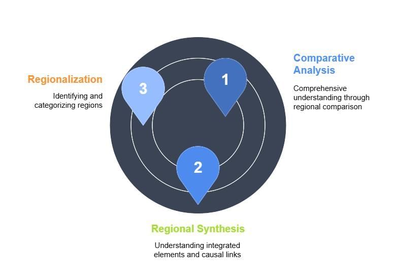
In summary, areal differentiation is a systematic approach to studying and understanding the unique characteristics of different regions. This method involves regionalization, regional synthesis, and comparative analysis, which together help create a detailed and coherent picture of various regions and their interrelations.
Criticism of Areal Differentiation
Areal Differentiation is a concept that attempts to assign distinct boundaries to various regions, but it faces criticism for several reasons. One major problem is that these boundaries are often dynamic and not static, as they are transitional zones subject to constant change. For example, climate zones and urban areas, like the expanding National Capital Region (NCR), cannot have fixed boundaries. Additionally, the territoriality of social groups is dynamic and cannot be reduced to a single, temporally fixed set of spatial units.
- Schaeffer criticized Areal Differentiation, calling it exceptionalism in World Geography and naming Kant as the Father of Exceptionalism. He argued that the approach made geography a more complicated and complex science, and instead favored a systems approach like generalizations and the nomothetic approach.
- Haggett, another critic of Areal Differentiation, focused on Areal Integration. The approach has been criticized as being incapable of contributing effectively to generalizations. Schaeffer suggested that geography should be a law-seeking subject, similar to physical sciences, and that mere description could not lead to the discipline's development. Following World War II, Areal Differentiation was largely rejected, giving way to the growth of Nomothetic Geography.
- Another issue with Areal Differentiation is that regions and their features are not isolated entities. They are the result of interactions with neighboring regions, leading to further classifications, such as studying Delhi and its adjoining regions together. The approach also presupposes determinism, as seen in the theories of Blache and the evolution of Possibilism.
- Critics argue that Areal Differentiation is overly descriptive, lacks clear demarcation, and focuses on regional totality rather than individual elements. It is also limited in its ability to classify regions further, leading to the development of a new theory called Regional Synthesis.
Current Status and Relevance of Areal Differentiation
The concept of Areal Differentiation has regained its significance in the field of Geography in recent times. This is because it plays a crucial role in various aspects such as:- Regional Planning and Resource Planning
- Development of backward and tribal areas
- Addressing Naxalism and its underlying causes (physical and non-physical factors)
- Agricultural zoning
- Management of epidemic disasters, such as the Zika Virus
In India, the government is currently focusing on developing 100 smart cities. However, the same development model cannot be applied to all these cities as each city has its own unique characteristics and needs. For example:
Varanasi: A Religious City
- Development of Ganga Ghats
- Promotion of Classical Music
- Support for the Varanasi Sari Industry
- Maintenance of Temple and Street Cleanliness
- Improved Communication, Connectivity, and Security for Foreign Tourists

Kanpur: An Industrial Hub
- Development of Textile and Leather Industries
- High-Quality Transport Facilities for Efficient Goods Movement
- Water Conservation Measures for Textile and Leather Industries
- Water Treatment Plants to Prevent Pollution from Textile and Leather Industries
By using Areal Differentiation, regional planning can be tailored to meet the specific needs of each area, helping to reduce social inequalities and promote balanced development.
Conclusion
Areal differentiation is a vital concept in geography that helps us understand the unique characteristics of different regions and how they interact with one another. By studying the variations in human and natural phenomena across areas, geographers can gain insights into the complex relationships between climate, vegetation, population patterns, and other factors. This understanding is crucial for effective regional planning, resource allocation, and addressing social inequalities. Despite some criticisms, areal differentiation remains relevant in today's world as we strive for balanced development and sustainable management of our regions.Frequently Asked Questions (FAQs) of Areal Differentiation
What is Areal Differentiation, and why is it important in the study of geography?
Areal Differentiation is the study of variations in human and physical phenomena across different regions and their relationships with other spatially close and causally linked phenomena. It is important in geography as it helps in understanding how various factors, such as climate, vegetation, and population patterns, differ across different areas and how these differences are related to one another.
Who first introduced the concept of Areal Differentiation?
The concept of Areal Differentiation was first introduced by Hartshorne in his seminal work "The Nature of Geography" published in 1939.
What are the three main steps involved in the methodology of Areal Differentiation?
The three main steps involved in the methodology of Areal Differentiation are: (1) Regionalization, which focuses on identifying and categorizing regions; (2) Regional Synthesis, which involves understanding the integrated nature of different elements and phenomena within a region, as well as identifying causal links between them; and (3) Comparative Analysis, which involves studying and comparing different regions that are either adjacent or related to each other.
What are some criticisms of Areal Differentiation?
Critics argue that Areal Differentiation is overly descriptive, lacks clear demarcation, and focuses on regional totality rather than individual elements. It is also limited in its ability to classify regions further, leading to the development of a new theory called Regional Synthesis. Additionally, Areal Differentiation has been criticized for its dynamic and transitional nature, which makes it difficult to assign fixed boundaries to various regions.
How is Areal Differentiation relevant in today's world?
Areal Differentiation is relevant in today's world as it plays a crucial role in various aspects such as regional planning, resource planning, development of backward and tribal areas, addressing Naxalism and its underlying causes, agricultural zoning, and management of epidemic disasters. By applying the concept of Areal Differentiation, regional planning can be customized to address the specific needs of each area, thereby reducing social disparities and fostering balanced development.
|
303 videos|635 docs|252 tests
|
FAQs on Areal Differentiation - Geography Optional for UPSC
| 1. What is the main reason for the revival of areal differentiation? |  |
| 2. What is the methodology of areal differentiation? | |
| 3. What is the current status and relevance of areal differentiation? | |
| 4. How does areal differentiation contribute to the study of regional development? | |
| 5. Can areal differentiation be applied to global-scale analysis? | |


Sample Paper
,Areal Differentiation | Geography Optional for UPSC
,Summary
,shortcuts and tricks
,Extra Questions
,Areal Differentiation | Geography Optional for UPSC
,Important questions
,past year papers
,practice quizzes
,Areal Differentiation | Geography Optional for UPSC
,Viva Questions
,Semester Notes
,video lectures
,Exam
,Free
,ppt
,mock tests for examination
,Previous Year Questions with Solutions
,MCQs
,study material
,Objective type Questions
;


Areal Differentiation Free PDF Download
Importance of Areal Differentiation
Areal Differentiation Notes
Areal Differentiation UPSC Questions
Study Areal Differentiation on the App
|
© EduRev
|
Education Revolution
|


|


